Spirit retrospective, - a few details from my current project |

Spirit retrospective, - a few details from my current project |
 Jan 20 2012, 09:13 PM Jan 20 2012, 09:13 PM
Post
#1
|
||
|
Solar System Cartographer  Group: Members Posts: 10229 Joined: 5-April 05 From: Canada Member No.: 227 |
I'm working on Spirit at the moment. I will post a few examples of things as I go.
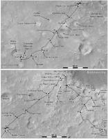
Right now the important job is updating the contemporary route map by locating the stops on HiRISE images. The existing maps at JPL, for the early part of the mission, were plotted on MOC images with inferior resolution and lighting, so I find many locations were about 15 or 20 m out. So at every site I am making circular panoramas (examples later) for comparison with HiRISE. Here's a first example, a map of the route during the Primary Mission. I have added a few extra placenames from the MER Analyst's Notebook at PDS. Phil
-------------------- ... because the Solar System ain't gonna map itself.
Also to be found posting similar content on https://mastodon.social/@PhilStooke Maps for download (free PDF: https://upload.wikimedia.org/wikipedia/comm...Cartography.pdf NOTE: everything created by me which I post on UMSF is considered to be in the public domain (NOT CC, public domain) |
|
 |
 
|
|
 |
|
May 27 2012, 05:55 PM
Post
#2
|
||
|
Solar System Cartographer Group: Members Posts: 10229 Joined: 5-April 05 From: Canada Member No.: 227 |
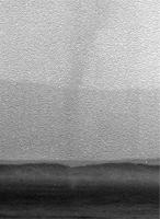
One other goodie. On sol 620 Spirit was on the summit of Husband Hill, taking a big panorama. This subframe is looking due east with three horizons visible - the near rim of Thira crater, the far rim of Thira, and in the distance the rim of Gusev itself. And in front of Thira is a towering dust devil. We normally see these DD images with the sky brightened enough to reveal the DD on the ground, overexposing anything in the sky. Here (from the 16 bit data) is the full vertical extent (cropped by the top of the frame). I found it while making a full mosaic of the rim of Gusev.
Phil
-------------------- ... because the Solar System ain't gonna map itself.
Also to be found posting similar content on https://mastodon.social/@PhilStooke Maps for download (free PDF: https://upload.wikimedia.org/wikipedia/comm...Cartography.pdf NOTE: everything created by me which I post on UMSF is considered to be in the public domain (NOT CC, public domain) |
|
|
|
|
|
 Phil Stooke Spirit retrospective Jan 20 2012, 09:13 PM
 john_s Gorgeous! Are these for a book?
John Jan 20 2012, 09:35 PM jasedm I like that a lot Phil - very nice.
There seems ... Jan 20 2012, 10:22 PM nprev VERY nice work, Phil!!!! Jan 20 2012, 11:00 PM Phil Stooke Hi John - it's for this book:
http://www.unma... Jan 20 2012, 11:26 PM
john_s Gorgeous! Are these for a book?
John Jan 20 2012, 09:35 PM jasedm I like that a lot Phil - very nice.
There seems ... Jan 20 2012, 10:22 PM nprev VERY nice work, Phil!!!! Jan 20 2012, 11:00 PM Phil Stooke Hi John - it's for this book:
http://www.unma... Jan 20 2012, 11:26 PM
 MizarKey I wonder if they regret not going around Bonnevill... Jan 21 2012, 06:47 AM djellison How would driving to the heatshield have avoided t... Jan 21 2012, 07:27 AM ElkGroveDan QUOTE (djellison @ Jan 20 2012, 11:27 PM)... Jan 21 2012, 02:53 PM centsworth_II And don't forget that Spirit made some fantast... Jan 21 2012, 04:27 PM PDP8E (1) Having Spirit driving to its crumbled heat-shi... Jan 21 2012, 04:52 PM djellison QUOTE (PDP8E @ Jan 21 2012, 08:52 AM) (2)... Jan 21 2012, 05:07 PM atomoid imho, the wreck of Oppy's heatshield was one o... Feb 4 2012, 12:14 AM climber Rob Manning recentely wrote about this here (i thi... Feb 4 2012, 08:44 AM centsworth_II QUOTE (climber @ Feb 4 2012, 03:44 AM) Ro... Feb 4 2012, 03:29 PM Phil Stooke Here's another example of recent work. Hank... Feb 6 2012, 05:43 PM Phil Stooke ... and a comparison of project mapping and my new... Feb 6 2012, 05:55 PM Phil Stooke Another little detail from long ago and far away..... Mar 4 2012, 03:05 PM elakdawalla Speaking of Spirit retrospective, we (that is, the... Mar 5 2012, 05:24 AM Phil Stooke Right now those reports are spread out among lots ... Mar 5 2012, 03:31 PM Phil Stooke Time for another blast from ye olde past: Spirit ... Apr 16 2012, 07:22 PM Phil Stooke A final blast from ye olde past at Spirit's si... May 27 2012, 05:35 PM Phil Stooke That last image was from a new study of the rim of... Jun 3 2012, 03:36 PM ngunn Very nice Phil!
As it happens I've re... Jun 3 2012, 04:34 PM Phil Stooke I don't remember that. If it was seen before ... Jun 3 2012, 08:11 PM Phil Stooke Sightlines plotted on a merge of THEMIS IR data (w... Jun 3 2012, 08:52 PM ngunn It looks like it's on that line you've dra... Jun 3 2012, 09:14 PM ngunn Phil, can you put a scale on that image? Jun 3 2012, 09:47 PM fredk There was some related discussion in this thread m... Jun 3 2012, 09:59 PM Phil Stooke "Phil, can you put a scale on that image?... Jun 3 2012, 11:06 PM ngunn Thanks Phil and fredk. Unfortunately the links in ... Jun 4 2012, 08:51 AM Phil Stooke Yes, it's sad to go back and see all the thing... Jun 4 2012, 02:17 PM djellison Imagehost, XS and others have all gone away or hav... Jun 4 2012, 03:54 PM fredk If anyone's curious, here are a couple of the ... Jun 9 2012, 03:21 PM ngunn Well rescued! There's all the infor... Jun 9 2012, 04:01 PM fredk So as far as seeing outside of Gusev, I've mar... Jun 9 2012, 07:17 PM ngunn QUOTE (fredk @ Jun 9 2012, 08:17 PM) We c... Jun 9 2012, 09:31 PM fredk QUOTE (ngunn @ Jun 9 2012, 10:31 PM) Ther... Jun 9 2012, 09:39 PM Phil Stooke Will do when I get to the office on Monday.
Phil Jun 9 2012, 07:35 PM Phil Stooke One other thing which I have not done yet... these... Jun 10 2012, 01:03 PM Phil Stooke OK, here is a cropped version of my full horizon p... Jun 11 2012, 02:25 PM jasedm That's awesome!! Jun 11 2012, 04:47 PM Phil Stooke Ugliest pan ever!
Phil Jun 11 2012, 05:20 PM MoreInput QUOTE (Phil Stooke @ Jun 11 2012, 07:20 P... Jun 11 2012, 08:01 PM machi Cool, ugly panorama!
So many peaks everywh... Jun 11 2012, 08:55 PM cbcnasa Amazing even if it is ugly Jun 11 2012, 11:18 PM Astro0 Just a little side note...
Today would have marke... Jun 12 2012, 05:11 AM fredk QUOTE (Deimos @ Jul 6 2012, 03:07 PM) We ... Jul 9 2012, 10:55 PM Phil Stooke It's not my thread! It belongs to all of ... Jul 9 2012, 11:45 PM CosmicRocker Yes, very nice work, Fred. Thanks. Jul 11 2012, 04:33 AM Phil Stooke Here's a text file containing descriptions of ... Mar 8 2013, 10:34 PM vikingmars Thanks a lot Phil : yes very useful. I'll comp... Mar 22 2013, 12:37 PM Phil Stooke Looking back at our dear departed Spirit one more ... Jun 24 2013, 07:40 PM vikingmars QUOTE (Phil Stooke @ Jun 24 2013, 09:40 P... Jun 25 2013, 06:19 PM ElkGroveDan Amazing Phil. Never would have thought you could ... Jun 24 2013, 10:47 PM PDP8E Phil, that is incredible!, thanks Jun 25 2013, 03:58 AM RoverDriver wow, just wow. I can't imagine what Phil woul... Jun 25 2013, 11:33 PM djellison I have concerns over what he might attempt with re... Jun 26 2013, 12:01 AM brellis Gorgeous, Phil - it needs to be on the cover of a ... Jun 26 2013, 12:03 AM Phil Stooke You write it, I'll provide the cover art!
... Jun 26 2013, 12:04 AM JohnVV A synthetically bumped up copy of Phobos Jun 27 2013, 05:13 AM Bill Harris More and more detail!! I tried to find ... Jun 27 2013, 08:16 AM Phil Stooke This is the same viewing angle but different light... Jun 27 2013, 03:33 PM RoverDriver QUOTE (Phil Stooke @ Jun 27 2013, 07:33 A... Jun 27 2013, 05:06 PM Ant103 This is just GREAT Phil, I love this kind of work Jun 27 2013, 03:37 PM Phil Stooke And I love your work!
Phil Jun 27 2013, 04:21 PM Bill Harris That is what I ran into-- "same viewing angle... Jun 27 2013, 05:09 PM Phil Stooke "I wonder if HiRISE was ever pointed at anyth... Jun 27 2013, 06:00 PM Phil Stooke And - this is Mars Express - it's from a seque... Jun 27 2013, 06:09 PM Ant103 About PDS imagery, I think I forget to show you th... Jul 5 2013, 12:14 PM vikingmars QUOTE (Ant103 @ Jul 5 2013, 02:14 PM) Abo... Jul 14 2013, 08:54 PM Phil Stooke Spectacular! I love those oblique lighting ima... Jul 5 2013, 01:25 PM
MizarKey I wonder if they regret not going around Bonnevill... Jan 21 2012, 06:47 AM djellison How would driving to the heatshield have avoided t... Jan 21 2012, 07:27 AM ElkGroveDan QUOTE (djellison @ Jan 20 2012, 11:27 PM)... Jan 21 2012, 02:53 PM centsworth_II And don't forget that Spirit made some fantast... Jan 21 2012, 04:27 PM PDP8E (1) Having Spirit driving to its crumbled heat-shi... Jan 21 2012, 04:52 PM djellison QUOTE (PDP8E @ Jan 21 2012, 08:52 AM) (2)... Jan 21 2012, 05:07 PM atomoid imho, the wreck of Oppy's heatshield was one o... Feb 4 2012, 12:14 AM climber Rob Manning recentely wrote about this here (i thi... Feb 4 2012, 08:44 AM centsworth_II QUOTE (climber @ Feb 4 2012, 03:44 AM) Ro... Feb 4 2012, 03:29 PM Phil Stooke Here's another example of recent work. Hank... Feb 6 2012, 05:43 PM Phil Stooke ... and a comparison of project mapping and my new... Feb 6 2012, 05:55 PM Phil Stooke Another little detail from long ago and far away..... Mar 4 2012, 03:05 PM elakdawalla Speaking of Spirit retrospective, we (that is, the... Mar 5 2012, 05:24 AM Phil Stooke Right now those reports are spread out among lots ... Mar 5 2012, 03:31 PM Phil Stooke Time for another blast from ye olde past: Spirit ... Apr 16 2012, 07:22 PM Phil Stooke A final blast from ye olde past at Spirit's si... May 27 2012, 05:35 PM Phil Stooke That last image was from a new study of the rim of... Jun 3 2012, 03:36 PM ngunn Very nice Phil!
As it happens I've re... Jun 3 2012, 04:34 PM Phil Stooke I don't remember that. If it was seen before ... Jun 3 2012, 08:11 PM Phil Stooke Sightlines plotted on a merge of THEMIS IR data (w... Jun 3 2012, 08:52 PM ngunn It looks like it's on that line you've dra... Jun 3 2012, 09:14 PM ngunn Phil, can you put a scale on that image? Jun 3 2012, 09:47 PM fredk There was some related discussion in this thread m... Jun 3 2012, 09:59 PM Phil Stooke "Phil, can you put a scale on that image?... Jun 3 2012, 11:06 PM ngunn Thanks Phil and fredk. Unfortunately the links in ... Jun 4 2012, 08:51 AM Phil Stooke Yes, it's sad to go back and see all the thing... Jun 4 2012, 02:17 PM djellison Imagehost, XS and others have all gone away or hav... Jun 4 2012, 03:54 PM fredk If anyone's curious, here are a couple of the ... Jun 9 2012, 03:21 PM ngunn Well rescued! There's all the infor... Jun 9 2012, 04:01 PM fredk So as far as seeing outside of Gusev, I've mar... Jun 9 2012, 07:17 PM ngunn QUOTE (fredk @ Jun 9 2012, 08:17 PM) We c... Jun 9 2012, 09:31 PM fredk QUOTE (ngunn @ Jun 9 2012, 10:31 PM) Ther... Jun 9 2012, 09:39 PM Phil Stooke Will do when I get to the office on Monday.
Phil Jun 9 2012, 07:35 PM Phil Stooke One other thing which I have not done yet... these... Jun 10 2012, 01:03 PM Phil Stooke OK, here is a cropped version of my full horizon p... Jun 11 2012, 02:25 PM jasedm That's awesome!! Jun 11 2012, 04:47 PM Phil Stooke Ugliest pan ever!
Phil Jun 11 2012, 05:20 PM MoreInput QUOTE (Phil Stooke @ Jun 11 2012, 07:20 P... Jun 11 2012, 08:01 PM machi Cool, ugly panorama!
So many peaks everywh... Jun 11 2012, 08:55 PM cbcnasa Amazing even if it is ugly Jun 11 2012, 11:18 PM Astro0 Just a little side note...
Today would have marke... Jun 12 2012, 05:11 AM fredk QUOTE (Deimos @ Jul 6 2012, 03:07 PM) We ... Jul 9 2012, 10:55 PM Phil Stooke It's not my thread! It belongs to all of ... Jul 9 2012, 11:45 PM CosmicRocker Yes, very nice work, Fred. Thanks. Jul 11 2012, 04:33 AM Phil Stooke Here's a text file containing descriptions of ... Mar 8 2013, 10:34 PM vikingmars Thanks a lot Phil : yes very useful. I'll comp... Mar 22 2013, 12:37 PM Phil Stooke Looking back at our dear departed Spirit one more ... Jun 24 2013, 07:40 PM vikingmars QUOTE (Phil Stooke @ Jun 24 2013, 09:40 P... Jun 25 2013, 06:19 PM ElkGroveDan Amazing Phil. Never would have thought you could ... Jun 24 2013, 10:47 PM PDP8E Phil, that is incredible!, thanks Jun 25 2013, 03:58 AM RoverDriver wow, just wow. I can't imagine what Phil woul... Jun 25 2013, 11:33 PM djellison I have concerns over what he might attempt with re... Jun 26 2013, 12:01 AM brellis Gorgeous, Phil - it needs to be on the cover of a ... Jun 26 2013, 12:03 AM Phil Stooke You write it, I'll provide the cover art!
... Jun 26 2013, 12:04 AM JohnVV A synthetically bumped up copy of Phobos Jun 27 2013, 05:13 AM Bill Harris More and more detail!! I tried to find ... Jun 27 2013, 08:16 AM Phil Stooke This is the same viewing angle but different light... Jun 27 2013, 03:33 PM RoverDriver QUOTE (Phil Stooke @ Jun 27 2013, 07:33 A... Jun 27 2013, 05:06 PM Ant103 This is just GREAT Phil, I love this kind of work Jun 27 2013, 03:37 PM Phil Stooke And I love your work!
Phil Jun 27 2013, 04:21 PM Bill Harris That is what I ran into-- "same viewing angle... Jun 27 2013, 05:09 PM Phil Stooke "I wonder if HiRISE was ever pointed at anyth... Jun 27 2013, 06:00 PM Phil Stooke And - this is Mars Express - it's from a seque... Jun 27 2013, 06:09 PM Ant103 About PDS imagery, I think I forget to show you th... Jul 5 2013, 12:14 PM vikingmars QUOTE (Ant103 @ Jul 5 2013, 02:14 PM) Abo... Jul 14 2013, 08:54 PM Phil Stooke Spectacular! I love those oblique lighting ima... Jul 5 2013, 01:25 PM |

|
Lo-Fi Version | Time is now: 26th September 2024 - 08:49 AM |
|
RULES AND GUIDELINES Please read the Forum Rules and Guidelines before posting. IMAGE COPYRIGHT |
OPINIONS AND MODERATION Opinions expressed on UnmannedSpaceflight.com are those of the individual posters and do not necessarily reflect the opinions of UnmannedSpaceflight.com or The Planetary Society. The all-volunteer UnmannedSpaceflight.com moderation team is wholly independent of The Planetary Society. The Planetary Society has no influence over decisions made by the UnmannedSpaceflight.com moderators. |
SUPPORT THE FORUM Unmannedspaceflight.com is funded by the Planetary Society. Please consider supporting our work and many other projects by donating to the Society or becoming a member. |
|