MSL landing site: Gale Crater |

MSL landing site: Gale Crater |
 Jun 23 2011, 05:13 AM Jun 23 2011, 05:13 AM
Post
#101
|
|
 Administrator  Group: Admin Posts: 5172 Joined: 4-August 05 From: Pasadena, CA, USA, Earth Member No.: 454 |
-------------------- My website - My Patreon - @elakdawalla on Twitter - Please support unmannedspaceflight.com by donating here.
|
 |
 
|
 |
|
Jul 17 2012, 02:12 PM
Post
#102
|
||
|
Solar System Cartographer Group: Members Posts: 10197 Joined: 5-April 05 From: Canada Member No.: 227 |
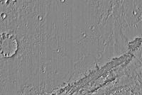
This is a full resolution - but quite compressed - CTX mosaic of the ellipse area.
Phil
-------------------- ... because the Solar System ain't gonna map itself.
Also to be found posting similar content on https://mastodon.social/@PhilStooke Maps for download (free PD: https://upload.wikimedia.org/wikipedia/comm...Cartography.pdf NOTE: everything created by me which I post on UMSF is considered to be in the public domain (NOT CC, public domain) |
|
|
|
|
|
|
Jul 17 2012, 07:56 PM
Post
#103
|
||
 Senior Member Group: Members Posts: 1465 Joined: 9-February 04 From: Columbus OH USA Member No.: 13 |
QUOTE (Phil Stooke @ Jul 17 2012, 10:12 AM)  This is a full resolution - but quite compressed - CTX mosaic of the ellipse area. Phil
Is an image available at full CTX resolution but of the entire Gale Crater? How about HiRISE resolution of the ellipse or larger area? I'm thinking of something suitable for printing very large. -------------------- |
|
|
|
|
|
|
Jul 17 2012, 09:17 PM
Post
#104
|
|
|
Member Group: Admin Posts: 976 Joined: 29-September 06 From: Pasadena, CA - USA Member No.: 1200 |
QUOTE (jmknapp @ Jul 17 2012, 12:56 PM) Is an image available at full CTX resolution but of the entire Gale Crater? How about HiRISE resolution of the ellipse or larger area? I'm thinking of something suitable for printing very large. These are all the HiRISE images that I have analyzed for traversability. If you go to the HiRISE server that lists all the DTMs http://hirise.lpl.arizona.edu/dtm/ you can download the DTMs and orthophotos for both "eyes". I stitched them together pretty easily just applying a horizontal and vertical offset. My 1mpp mosaic is about 30000x46250 pixels. Managing the mosaic at .25mpp proved to be a bit cumbersome. ESP_011562_1755 ESP_012551_1750 ESP_018854_1755 ESP_019698_1750 ESP_023957_1755 ESP_024102_1755 ESP_024102_175N ESP_024234_1755 PSP_001488_1750 PSP_009294_1750 PSP_009505_1755 PSP_009716_1755 PSP_010573_1755 There are some additional HiRISE mono images but I don't have a full list but I can find out if anyone is interested. Paolo -------------------- Disclaimer: all opinions, ideas and information included here are my own,and should not be intended to represent opinion or policy of my employer.
|
|
|
|
|
Jul 18 2012, 11:43 AM
Post
#105
|
|
|
Senior Member Group: Members Posts: 1465 Joined: 9-February 04 From: Columbus OH USA Member No.: 13 |
QUOTE (RoverDriver @ Jul 17 2012, 05:17 PM) These are all the HiRISE images that I have analyzed for traversability. Thanks. One thing: QUOTE ESP_024102_175N That's a typo I guess? Also, I'm curious to know about the software you use for stitching these huge images together. Seems like Photoshop CS5 chokes on the largest ones, at least on my machine. -------------------- |
|
|
|
|
Jul 18 2012, 04:54 PM
Post
#106
|
|
|
Member Group: Admin Posts: 976 Joined: 29-September 06 From: Pasadena, CA - USA Member No.: 1200 |
QUOTE (jmknapp @ Jul 18 2012, 04:43 AM) Thanks. One thing: That's a typo I guess? No, it is not a typo. That image has been split in two parts when generating the DEM. For whatever reason they could not generate a single set of orthophotos to compute range data. I decided to call the upper part with the suffix N for North. If you are downloading and analyzing the images you can safely remove this from your list. QUOTE Also, I'm curious to know about the software you use for stitching these huge images together. Seems like Photoshop CS5 chokes on the largest ones, at least on my machine. I rolled my own. All code for traversability analysis (about 15,000 lines of code) has been developed in house. The stitching was tricky because some of the resulting mosaics had files larger than 4GB. I haven't tried, but maybe the netpbm tools, imagemagick or ImageJ can handle this task. Paolo -------------------- Disclaimer: all opinions, ideas and information included here are my own,and should not be intended to represent opinion or policy of my employer.
|
|
|
|
 elakdawalla MSL landing site: Gale Crater Jun 23 2011, 05:13 AM
 PDP8E nirgal,
Your 23rd century image skills are very i... Aug 4 2011, 06:57 PM mhoward Really great stuff, Nirgal. Currently on my deskto... Aug 5 2011, 12:14 AM machi Nirgal, your images are really majestic! Aug 5 2011, 12:36 AM Oersted Anything similar to this near Gale?
http://www.nas... Aug 12 2011, 10:25 AM Paolo I don't think so. In any case it would be very... Aug 12 2011, 11:24 AM
PDP8E nirgal,
Your 23rd century image skills are very i... Aug 4 2011, 06:57 PM mhoward Really great stuff, Nirgal. Currently on my deskto... Aug 5 2011, 12:14 AM machi Nirgal, your images are really majestic! Aug 5 2011, 12:36 AM Oersted Anything similar to this near Gale?
http://www.nas... Aug 12 2011, 10:25 AM Paolo I don't think so. In any case it would be very... Aug 12 2011, 11:24 AM
 atomoid QUOTE (Paolo @ Aug 12 2011, 03:24 AM) htt... Aug 17 2011, 11:55 PM AdamH Hey folks,
Here are a couple of Youtube videos of... Sep 23 2011, 02:00 AM Oersted QUOTE (AdamH @ Sep 23 2011, 04:00 AM) Nex... Sep 26 2011, 09:00 PM AdamH QUOTE (Oersted @ Sep 26 2011, 10:00 PM) G... Sep 26 2011, 09:10 PM Oersted OMG, I still have a hard time getting my head arou... Sep 27 2011, 12:55 PM AdamH QUOTE (Oersted @ Sep 27 2011, 01:55 PM) O... Sep 27 2011, 01:34 PM Oersted Animated mystery man, woohoo!
Thanks, this re... Sep 28 2011, 07:19 AM AdamH Here's a Gale Crater flyaround tool I'd ap... Oct 4 2011, 01:42 PM Nirgal Thanks for this really cool software that enables ... Oct 4 2011, 08:38 PM AdamH I've removed the above GaleCrater flyaround; i... Dec 6 2011, 05:54 PM atomoid QUOTE (AdamH @ Dec 6 2011, 09:54 AM) ...e... Jan 20 2012, 06:22 PM pospa Gale crater central mound got a (informal) name - ... Mar 29 2012, 12:28 PM Oersted Thanks for the link, great read. Mar 29 2012, 10:37 PM belleraphon1 Great series of talks from last months Abscicon re... May 16 2012, 11:58 PM Phil Stooke Recently the informal name "Mount Sharp... May 18 2012, 11:41 PM elakdawalla Huh. The usage of "Mount Sharp" is alrea... May 19 2012, 12:07 AM JRehling On a linguistic note, Aeolis strikingly resembles ... May 23 2012, 07:43 PM Phil Stooke I think they will go with the official name, but m... May 19 2012, 12:24 AM nprev Odd that USGS & IAU would decide to affix a fo... May 19 2012, 02:31 AM Phil Stooke No, Aeolis is the region Gale is in. Gale itself ... May 19 2012, 02:58 AM nprev Got it; thanks, Phil!
Think Emily's right... May 19 2012, 06:06 AM djellison Got to say - this is a very silly move by the IAU. May 19 2012, 06:18 AM Stu Sounds like someone in the IAU has thrown his or h... May 19 2012, 07:14 AM djellison It's disrespectful to the team that's put ... May 19 2012, 08:06 AM Phil Stooke Sharp gets a crater nearby. By convention large M... May 19 2012, 10:51 AM mcaplinger It's worth pointing out that unlike decisions ... May 19 2012, 11:09 PM djellison The IAU could have just done nothing. What they... May 19 2012, 11:11 PM mcaplinger QUOTE (djellison @ May 19 2012, 03:11 PM)... May 19 2012, 11:15 PM PDP8E There are a seven named peaks in Gusev in the vici... May 19 2012, 11:37 PM djellison QUOTE (PDP8E @ May 19 2012, 04:37 PM) The... May 20 2012, 12:24 AM mcaplinger QUOTE (PDP8E @ May 19 2012, 03:37 PM) The... May 20 2012, 12:39 AM PDP8E ... there are 10 named hills in Gusev...add to the... May 20 2012, 01:08 AM mcaplinger QUOTE (PDP8E @ May 19 2012, 06:08 PM) ...... May 20 2012, 02:03 AM mhoward For what it's worth, I think Aeolis Mons makes... May 20 2012, 04:40 AM stevesliva QUOTE (mcaplinger @ May 19 2012, 07:39 PM... May 20 2012, 07:00 AM nprev Thanks for the reference image, Mike.
Gotta admit... May 20 2012, 07:23 AM Stu (sigh)
The timing of this was either simply unfor... May 20 2012, 09:51 AM Phil Stooke I don't think this type of speculation helps U... May 20 2012, 01:33 PM Stu Hmm, maybe that's a good idea; I was getting a... May 20 2012, 04:16 PM BrianL QUOTE (Stu @ May 20 2012, 11:16 AM) Shame... May 20 2012, 05:09 PM Phil Stooke The recent telecon on the resized landing ellipse ... Jun 12 2012, 06:41 PM jmknapp QUOTE (RoverDriver @ Jul 18 2012, 12:54 P... Jul 19 2012, 09:32 AM RoverDriver QUOTE (jmknapp @ Jul 19 2012, 01:32 AM) B... Jul 19 2012, 01:32 PM jmknapp QUOTE (RoverDriver @ Jul 19 2012, 09:32 A... Jul 20 2012, 11:45 AM RoverDriver QUOTE (jmknapp @ Jul 20 2012, 03:45 AM) T... Jul 20 2012, 02:46 PM jmknapp QUOTE (RoverDriver @ Jul 20 2012, 10:46 A... Jul 23 2012, 12:35 AM RoverDriver QUOTE (jmknapp @ Jul 22 2012, 05:35 PM) T... Jul 23 2012, 04:04 AM jmknapp QUOTE (RoverDriver @ Jul 23 2012, 12:04 A... Jul 23 2012, 09:53 AM akuo Has there been any study of the traversability of ... Jul 17 2012, 07:22 PM RoverDriver QUOTE (akuo @ Jul 17 2012, 12:22 PM) Has ... Jul 17 2012, 09:22 PM Phil Stooke Yes, lots, including recent operations with a test... Jul 17 2012, 07:27 PM brellis Dang I'm already eating so many pistachios in ... Jul 17 2012, 07:39 PM Phil Stooke Leave a few for us!
Phil Jul 17 2012, 07:43 PM Phil Stooke Not yet! (yes, the images exist, but no, not ... Jul 17 2012, 08:22 PM Stu Phil,
Hope you don't mind, I took your great ... Jul 17 2012, 08:27 PM Phil Stooke That's what it's for!
There's a l... Jul 17 2012, 08:56 PM kwan3217 Several minutes of google did not reveal the coord... Jul 17 2012, 10:15 PM Astro0 Really?
Read the MSL Landing Press Kit.
or here ... Jul 17 2012, 10:41 PM Syrinx Re: The pic Stu posted with the target ellipse.
W... Jul 17 2012, 11:46 PM djellison QUOTE (Syrinx @ Jul 17 2012, 03:46 PM) Wi... Jul 18 2012, 12:14 AM Phil Stooke North is always up in anything I do, unless I forg... Jul 18 2012, 12:00 AM RoverDriver QUOTE (Phil Stooke @ Jul 17 2012, 05:00 P... Jul 18 2012, 01:16 AM fredk QUOTE (RoverDriver @ Jul 18 2012, 01:16 A... Jul 18 2012, 04:00 AM Phil Stooke I should be more specific and say that north is cl... Jul 18 2012, 02:42 AM Stu QUOTE (RoverDriver @ Jul 18 2012, 02:16 A... Jul 18 2012, 07:37 AM RoverDriver QUOTE (Stu @ Jul 18 2012, 12:37 AM) Hmm. ... Jul 18 2012, 05:06 PM Phil Stooke Stu - if you rotated mine to fit the NASA one (ins... Jul 18 2012, 12:32 PM Stu Thanks Phil. Is it really that far out that I need... Jul 18 2012, 12:46 PM Phil Stooke No, it's not far out. Don't bother - your... Jul 18 2012, 12:50 PM Stu Ohhhhhh......
Now I've *got* to do it, ... Jul 18 2012, 01:11 PM Astro0 If for nothing else, Gale Crater is going to be a ... Jul 20 2012, 10:15 AM jamescanvin Re: Handling HiRISE images. When I've worked t... Jul 20 2012, 01:00 PM Mars Attack Great pics Astro! Does anyone know just how... Jul 20 2012, 02:13 PM Phil Stooke "Matt Golombek was pretty clear that MSL will... Jul 20 2012, 04:11 PM vjkane QUOTE (Phil Stooke @ Jul 20 2012, 08:11 A... Jul 20 2012, 10:26 PM Phil Stooke A very good point, and I think there are other fan... Jul 20 2012, 11:01 PM RoverDriver QUOTE (Phil Stooke @ Jul 20 2012, 04:01 P... Jul 20 2012, 11:06 PM vjkane QUOTE (RoverDriver @ Jul 20 2012, 03:06 P... Jul 20 2012, 11:12 PM RoverDriver QUOTE (vjkane @ Jul 20 2012, 04:12 PM) Th... Jul 21 2012, 12:58 AM Phil Stooke We can play endless games about extended missions,... Jul 20 2012, 11:34 PM Astro0 QUOTE Which one are you missing?
Paolo
The bit I... Jul 21 2012, 06:00 AM RoverDriver QUOTE (Astro0 @ Jul 20 2012, 11:00 PM) Th... Jul 21 2012, 06:22 AM Astro0 QUOTE (RoverDriver @ Jul 21 2012, 04:22 P... Jul 21 2012, 10:45 AM RoverDriver QUOTE (Astro0 @ Jul 21 2012, 03:45 AM) Un... Jul 21 2012, 02:58 PM djellison Tanya's mosaic is CTX, not HiRISE. Jul 23 2012, 01:16 PM RoverDriver The mosaic that I work on is at 1mpp, 30000x46256 ... Jul 23 2012, 02:53 PM jmknapp QUOTE (RoverDriver @ Jul 23 2012, 10:53 A... Jul 23 2012, 04:17 PM RoverDriver QUOTE (jmknapp @ Jul 23 2012, 08:17 AM) H... Jul 23 2012, 11:01 PM nprev Paolo, please don't stress. If there's any... Jul 23 2012, 11:27 PM RoverDriver Joe (jmknapp) sent me a PM whose reply might be of... Jul 24 2012, 01:29 AM
atomoid QUOTE (Paolo @ Aug 12 2011, 03:24 AM) htt... Aug 17 2011, 11:55 PM AdamH Hey folks,
Here are a couple of Youtube videos of... Sep 23 2011, 02:00 AM Oersted QUOTE (AdamH @ Sep 23 2011, 04:00 AM) Nex... Sep 26 2011, 09:00 PM AdamH QUOTE (Oersted @ Sep 26 2011, 10:00 PM) G... Sep 26 2011, 09:10 PM Oersted OMG, I still have a hard time getting my head arou... Sep 27 2011, 12:55 PM AdamH QUOTE (Oersted @ Sep 27 2011, 01:55 PM) O... Sep 27 2011, 01:34 PM Oersted Animated mystery man, woohoo!
Thanks, this re... Sep 28 2011, 07:19 AM AdamH Here's a Gale Crater flyaround tool I'd ap... Oct 4 2011, 01:42 PM Nirgal Thanks for this really cool software that enables ... Oct 4 2011, 08:38 PM AdamH I've removed the above GaleCrater flyaround; i... Dec 6 2011, 05:54 PM atomoid QUOTE (AdamH @ Dec 6 2011, 09:54 AM) ...e... Jan 20 2012, 06:22 PM pospa Gale crater central mound got a (informal) name - ... Mar 29 2012, 12:28 PM Oersted Thanks for the link, great read. Mar 29 2012, 10:37 PM belleraphon1 Great series of talks from last months Abscicon re... May 16 2012, 11:58 PM Phil Stooke Recently the informal name "Mount Sharp... May 18 2012, 11:41 PM elakdawalla Huh. The usage of "Mount Sharp" is alrea... May 19 2012, 12:07 AM JRehling On a linguistic note, Aeolis strikingly resembles ... May 23 2012, 07:43 PM Phil Stooke I think they will go with the official name, but m... May 19 2012, 12:24 AM nprev Odd that USGS & IAU would decide to affix a fo... May 19 2012, 02:31 AM Phil Stooke No, Aeolis is the region Gale is in. Gale itself ... May 19 2012, 02:58 AM nprev Got it; thanks, Phil!
Think Emily's right... May 19 2012, 06:06 AM djellison Got to say - this is a very silly move by the IAU. May 19 2012, 06:18 AM Stu Sounds like someone in the IAU has thrown his or h... May 19 2012, 07:14 AM djellison It's disrespectful to the team that's put ... May 19 2012, 08:06 AM Phil Stooke Sharp gets a crater nearby. By convention large M... May 19 2012, 10:51 AM mcaplinger It's worth pointing out that unlike decisions ... May 19 2012, 11:09 PM djellison The IAU could have just done nothing. What they... May 19 2012, 11:11 PM mcaplinger QUOTE (djellison @ May 19 2012, 03:11 PM)... May 19 2012, 11:15 PM PDP8E There are a seven named peaks in Gusev in the vici... May 19 2012, 11:37 PM djellison QUOTE (PDP8E @ May 19 2012, 04:37 PM) The... May 20 2012, 12:24 AM mcaplinger QUOTE (PDP8E @ May 19 2012, 03:37 PM) The... May 20 2012, 12:39 AM PDP8E ... there are 10 named hills in Gusev...add to the... May 20 2012, 01:08 AM mcaplinger QUOTE (PDP8E @ May 19 2012, 06:08 PM) ...... May 20 2012, 02:03 AM mhoward For what it's worth, I think Aeolis Mons makes... May 20 2012, 04:40 AM stevesliva QUOTE (mcaplinger @ May 19 2012, 07:39 PM... May 20 2012, 07:00 AM nprev Thanks for the reference image, Mike.
Gotta admit... May 20 2012, 07:23 AM Stu (sigh)
The timing of this was either simply unfor... May 20 2012, 09:51 AM Phil Stooke I don't think this type of speculation helps U... May 20 2012, 01:33 PM Stu Hmm, maybe that's a good idea; I was getting a... May 20 2012, 04:16 PM BrianL QUOTE (Stu @ May 20 2012, 11:16 AM) Shame... May 20 2012, 05:09 PM Phil Stooke The recent telecon on the resized landing ellipse ... Jun 12 2012, 06:41 PM jmknapp QUOTE (RoverDriver @ Jul 18 2012, 12:54 P... Jul 19 2012, 09:32 AM RoverDriver QUOTE (jmknapp @ Jul 19 2012, 01:32 AM) B... Jul 19 2012, 01:32 PM jmknapp QUOTE (RoverDriver @ Jul 19 2012, 09:32 A... Jul 20 2012, 11:45 AM RoverDriver QUOTE (jmknapp @ Jul 20 2012, 03:45 AM) T... Jul 20 2012, 02:46 PM jmknapp QUOTE (RoverDriver @ Jul 20 2012, 10:46 A... Jul 23 2012, 12:35 AM RoverDriver QUOTE (jmknapp @ Jul 22 2012, 05:35 PM) T... Jul 23 2012, 04:04 AM jmknapp QUOTE (RoverDriver @ Jul 23 2012, 12:04 A... Jul 23 2012, 09:53 AM akuo Has there been any study of the traversability of ... Jul 17 2012, 07:22 PM RoverDriver QUOTE (akuo @ Jul 17 2012, 12:22 PM) Has ... Jul 17 2012, 09:22 PM Phil Stooke Yes, lots, including recent operations with a test... Jul 17 2012, 07:27 PM brellis Dang I'm already eating so many pistachios in ... Jul 17 2012, 07:39 PM Phil Stooke Leave a few for us!
Phil Jul 17 2012, 07:43 PM Phil Stooke Not yet! (yes, the images exist, but no, not ... Jul 17 2012, 08:22 PM Stu Phil,
Hope you don't mind, I took your great ... Jul 17 2012, 08:27 PM Phil Stooke That's what it's for!
There's a l... Jul 17 2012, 08:56 PM kwan3217 Several minutes of google did not reveal the coord... Jul 17 2012, 10:15 PM Astro0 Really?
Read the MSL Landing Press Kit.
or here ... Jul 17 2012, 10:41 PM Syrinx Re: The pic Stu posted with the target ellipse.
W... Jul 17 2012, 11:46 PM djellison QUOTE (Syrinx @ Jul 17 2012, 03:46 PM) Wi... Jul 18 2012, 12:14 AM Phil Stooke North is always up in anything I do, unless I forg... Jul 18 2012, 12:00 AM RoverDriver QUOTE (Phil Stooke @ Jul 17 2012, 05:00 P... Jul 18 2012, 01:16 AM fredk QUOTE (RoverDriver @ Jul 18 2012, 01:16 A... Jul 18 2012, 04:00 AM Phil Stooke I should be more specific and say that north is cl... Jul 18 2012, 02:42 AM Stu QUOTE (RoverDriver @ Jul 18 2012, 02:16 A... Jul 18 2012, 07:37 AM RoverDriver QUOTE (Stu @ Jul 18 2012, 12:37 AM) Hmm. ... Jul 18 2012, 05:06 PM Phil Stooke Stu - if you rotated mine to fit the NASA one (ins... Jul 18 2012, 12:32 PM Stu Thanks Phil. Is it really that far out that I need... Jul 18 2012, 12:46 PM Phil Stooke No, it's not far out. Don't bother - your... Jul 18 2012, 12:50 PM Stu Ohhhhhh......
Now I've *got* to do it, ... Jul 18 2012, 01:11 PM Astro0 If for nothing else, Gale Crater is going to be a ... Jul 20 2012, 10:15 AM jamescanvin Re: Handling HiRISE images. When I've worked t... Jul 20 2012, 01:00 PM Mars Attack Great pics Astro! Does anyone know just how... Jul 20 2012, 02:13 PM Phil Stooke "Matt Golombek was pretty clear that MSL will... Jul 20 2012, 04:11 PM vjkane QUOTE (Phil Stooke @ Jul 20 2012, 08:11 A... Jul 20 2012, 10:26 PM Phil Stooke A very good point, and I think there are other fan... Jul 20 2012, 11:01 PM RoverDriver QUOTE (Phil Stooke @ Jul 20 2012, 04:01 P... Jul 20 2012, 11:06 PM vjkane QUOTE (RoverDriver @ Jul 20 2012, 03:06 P... Jul 20 2012, 11:12 PM RoverDriver QUOTE (vjkane @ Jul 20 2012, 04:12 PM) Th... Jul 21 2012, 12:58 AM Phil Stooke We can play endless games about extended missions,... Jul 20 2012, 11:34 PM Astro0 QUOTE Which one are you missing?
Paolo
The bit I... Jul 21 2012, 06:00 AM RoverDriver QUOTE (Astro0 @ Jul 20 2012, 11:00 PM) Th... Jul 21 2012, 06:22 AM Astro0 QUOTE (RoverDriver @ Jul 21 2012, 04:22 P... Jul 21 2012, 10:45 AM RoverDriver QUOTE (Astro0 @ Jul 21 2012, 03:45 AM) Un... Jul 21 2012, 02:58 PM djellison Tanya's mosaic is CTX, not HiRISE. Jul 23 2012, 01:16 PM RoverDriver The mosaic that I work on is at 1mpp, 30000x46256 ... Jul 23 2012, 02:53 PM jmknapp QUOTE (RoverDriver @ Jul 23 2012, 10:53 A... Jul 23 2012, 04:17 PM RoverDriver QUOTE (jmknapp @ Jul 23 2012, 08:17 AM) H... Jul 23 2012, 11:01 PM nprev Paolo, please don't stress. If there's any... Jul 23 2012, 11:27 PM RoverDriver Joe (jmknapp) sent me a PM whose reply might be of... Jul 24 2012, 01:29 AM |

|
Lo-Fi Version | Time is now: 24th June 2024 - 07:06 PM |
|
RULES AND GUIDELINES Please read the Forum Rules and Guidelines before posting. IMAGE COPYRIGHT |
OPINIONS AND MODERATION Opinions expressed on UnmannedSpaceflight.com are those of the individual posters and do not necessarily reflect the opinions of UnmannedSpaceflight.com or The Planetary Society. The all-volunteer UnmannedSpaceflight.com moderation team is wholly independent of The Planetary Society. The Planetary Society has no influence over decisions made by the UnmannedSpaceflight.com moderators. |
SUPPORT THE FORUM Unmannedspaceflight.com is funded by the Planetary Society. Please consider supporting our work and many other projects by donating to the Society or becoming a member. |
|