LAMO, aka Low Altitude Mapping Orbit |

LAMO, aka Low Altitude Mapping Orbit |
 Nov 11 2011, 10:23 PM Nov 11 2011, 10:23 PM
Post
#1
|
||
 Senior Member  Group: Members Posts: 2492 Joined: 15-January 05 From: center Italy Member No.: 150 |
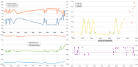
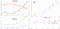
I think is time to start this new topic, now that Dawn is more than half-way in the transition from HAMO to LAMO (as showed in the plot below).
Attached thumbnail(s)
-------------------- I always think before posting! - Marco -
|
|
 |
 
|
|
 |
|
Jul 26 2012, 03:41 PM
Post
#2
|
|
|
Solar System Cartographer Group: Members Posts: 10192 Joined: 5-April 05 From: Canada Member No.: 227 |
I'm looking forward to seeing some whole-frame images during the departure, a different view than we had during the approach.
Phil -------------------- ... because the Solar System ain't gonna map itself.
Also to be found posting similar content on https://mastodon.social/@PhilStooke Maps for download (free PD: https://upload.wikimedia.org/wikipedia/comm...Cartography.pdf NOTE: everything created by me which I post on UMSF is considered to be in the public domain (NOT CC, public domain) |
|
|
|
|
Jul 26 2012, 08:32 PM
Post
#3
|
|||||
|
Senior Member Group: Members Posts: 2492 Joined: 15-January 05 From: center Italy Member No.: 150 |
Based on simulated viewer and yesterday's Marc report, engines were ON for more than 24 hours and, as showed in the following plots, Dawn orbit is rapidly changing:
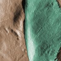
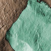
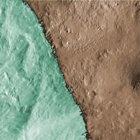
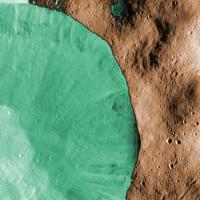
Last apoapsis was 776.5 km above Vesta surface, about 63 km above HAMO2 in last days... Total energy is clearly increasing too, however departure phase will last more than a month. Meanwhile, starting from Phil idea, I made these compositions of last 3 posted images in the "revealing shadows" series:
(first one is in Oppia quadrangle and latter two inside Marcia quadrangle). Consider that, for shadowed region, besides the different hue I used negative image in order to have an illumination roughly coherent with illuminated part. -------------------- I always think before posting! - Marco -
|
||||
|
|
|
||||
|
Jul 29 2012, 03:46 PM
Post
#4
|
|||
|
Senior Member Group: Members Posts: 2492 Joined: 15-January 05 From: center Italy Member No.: 150 |
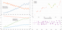
Further update on escape maneuver:
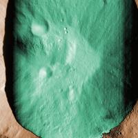
Dawn is rapidly receding from HAMO orbit thanks to uninterrupted engine thrust; based on simulator figures, during last orbit there was an increase of apoapsis/periapsis heights of 57.9/59.3 km (a rising rate greather than 80 km/day); total energy/mass increased by 2.1 kJ/Kg in 4 days. Added: same processing for the 5th image of "revealing shadows" series, in the Floronia quadrangle:
-------------------- I always think before posting! - Marco -
|
||
|
|
|
||
|
Aug 1 2012, 11:05 PM
Post
#5
|
||
|
Senior Member Group: Members Posts: 2492 Joined: 15-January 05 From: center Italy Member No.: 150 |
Further update:
The first engine stop, on July 31, lasted less than 15 hours and, after this, energy increase was very regular. -------------------- I always think before posting! - Marco -
|
|
|
|
|
|
|
Aug 5 2012, 06:08 AM
Post
#6
|
||||
|
Senior Member Group: Members Posts: 2492 Joined: 15-January 05 From: center Italy Member No.: 150 |
The second engine stop, on Aug 2-4, was longer (between 30 and 45 hours) and, probably, was used to map the northern emisphere; in fact Dawn flied twice above North Pole at an estimated height of 1450 km (considering Vesta shape). Herebelow last two "revealing shadow" processed images, from Caparronia and Floronia quadrangles, respectively:
-------------------- I always think before posting! - Marco -
|
|||
|
|
|
|||
 dilo LAMO Nov 11 2011, 10:23 PM
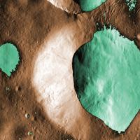
 machi Very interesting color image of the "Snowman... Aug 11 2012, 03:03 PM Phil Stooke http://pds-smallbodies.astro.umd.edu/data_...ase_s... Aug 14 2012, 12:03 AM lyford More reaction wheel problems:
http://www.nasa.... Aug 15 2012, 01:08 AM TheAnt Yes I got that from this news source.
Now that th... Aug 24 2012, 12:09 PM stevesliva Are there only two wheels? Aug 24 2012, 08:32 PM djellison Two fully functioning left of the 4 functioning at... Aug 24 2012, 10:09 PM
machi Very interesting color image of the "Snowman... Aug 11 2012, 03:03 PM Phil Stooke http://pds-smallbodies.astro.umd.edu/data_...ase_s... Aug 14 2012, 12:03 AM lyford More reaction wheel problems:
http://www.nasa.... Aug 15 2012, 01:08 AM TheAnt Yes I got that from this news source.
Now that th... Aug 24 2012, 12:09 PM stevesliva Are there only two wheels? Aug 24 2012, 08:32 PM djellison Two fully functioning left of the 4 functioning at... Aug 24 2012, 10:09 PM stevesliva There are some new captioned releases here:
http:/... Jan 5 2013, 07:32 AM
stevesliva There are some new captioned releases here:
http:/... Jan 5 2013, 07:32 AM |

|
Lo-Fi Version | Time is now: 14th June 2024 - 02:23 AM |
|
RULES AND GUIDELINES Please read the Forum Rules and Guidelines before posting. IMAGE COPYRIGHT |
OPINIONS AND MODERATION Opinions expressed on UnmannedSpaceflight.com are those of the individual posters and do not necessarily reflect the opinions of UnmannedSpaceflight.com or The Planetary Society. The all-volunteer UnmannedSpaceflight.com moderation team is wholly independent of The Planetary Society. The Planetary Society has no influence over decisions made by the UnmannedSpaceflight.com moderators. |
SUPPORT THE FORUM Unmannedspaceflight.com is funded by the Planetary Society. Please consider supporting our work and many other projects by donating to the Society or becoming a member. |
|