MSL Route Map |

MSL Route Map |
 Aug 29 2012, 08:52 PM Aug 29 2012, 08:52 PM
Post
#1
|
|||
|
Solar System Cartographer  Group: Members Posts: 10229 Joined: 5-April 05 From: Canada Member No.: 227 |
Thread created for posting MSL route maps and map updates.
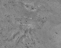
Comments / suggestions adding value to the route maps are allowed, but discussions regarding the route itself and "future" paths are not. Use the currently active thread for the latter. Eduardo Tesheiner Moderator ----- Here's an updated map of activities near the landing site and the start of a map of the route to Glenelg. I may get one more step added to this before I have to take a break Aug. 31 to Sept 16, and I will resume it after that. Details will be revised as necessary as we go. Phil
-------------------- ... because the Solar System ain't gonna map itself.
Also to be found posting similar content on https://mastodon.social/@PhilStooke Maps for download (free PDF: https://upload.wikimedia.org/wikipedia/comm...Cartography.pdf NOTE: everything created by me which I post on UMSF is considered to be in the public domain (NOT CC, public domain) |
||
 |
 
|
||
 |
|
Sep 17 2012, 08:42 PM
Post
#2
|
||
|
Solar System Cartographer Group: Members Posts: 10229 Joined: 5-April 05 From: Canada Member No.: 227 |
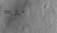
Route map update...
I am fairly happy with all locations except the last one, which is very preliminary - originally I had it further south but I like Markril's estimate. All features of the map may be updated retroactively from time to time. Phil
EDIT: Looks like the last drive should be a bit shorter, and the one before a bit longer... I will be adding a scaled grid to this later. -------------------- ... because the Solar System ain't gonna map itself.
Also to be found posting similar content on https://mastodon.social/@PhilStooke Maps for download (free PDF: https://upload.wikimedia.org/wikipedia/comm...Cartography.pdf NOTE: everything created by me which I post on UMSF is considered to be in the public domain (NOT CC, public domain) |
|
|
|
|
|
|
Sep 18 2012, 12:00 PM
Post
#3
|
|||
 Senior Member Group: Members Posts: 1465 Joined: 9-February 04 From: Columbus OH USA Member No.: 13 |
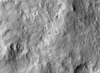
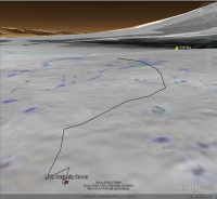
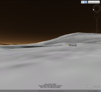
QUOTE (Phil Stooke @ Sep 17 2012, 04:42 PM)  Route map update... I put that track into Google Earth--here's the overall view of the track as seen from a point about 25 meters above the landing spot:
Even from that vantage, Glenelg is slightly below the horizon. The ground image is the slope map. The track appears to go through some rougher terrain, so maybe it went around that a bit? Green is 12.5°-25° slope (no traverse on sand, some slip on bedrock). Here's the ground-level view from the terminal point:
The pushpin for Glenelg is just peeking over the rise, so maybe it's not quite visible yet? GE elevation is based on MOLA and the "ground level" observation point in this case is from a height of 1.75 meters. Beeline range to Glenelg is about 190 meters, 170 meters to the landing site. KMZ file:  t40.kmz ( 1.46K )
Number of downloads: 2048
t40.kmz ( 1.46K )
Number of downloads: 2048-------------------- |
||
|
|
|
||
 Phil Stooke MSL Route Map Aug 29 2012, 08:52 PM
 Phil Stooke I would just like to add - don't necessarily t... Aug 30 2012, 08:52 PM nprev Copy that, Phil!
Course tracing plots from... Aug 30 2012, 08:59 PM elakdawalla While I will not be able to reliably update a rout... Aug 30 2012, 10:36 PM Pando Emily, how about using Google Mars KML? It can be ... Aug 30 2012, 10:55 PM
Phil Stooke I would just like to add - don't necessarily t... Aug 30 2012, 08:52 PM nprev Copy that, Phil!
Course tracing plots from... Aug 30 2012, 08:59 PM elakdawalla While I will not be able to reliably update a rout... Aug 30 2012, 10:36 PM Pando Emily, how about using Google Mars KML? It can be ... Aug 30 2012, 10:55 PM
 Tesheiner QUOTE (Pando @ Aug 31 2012, 12:55 AM) Emi... Aug 31 2012, 06:53 AM elakdawalla That makes sense. How did you do that? Is your rou... Aug 31 2012, 03:10 PM Tesheiner Well, it's more than that.
But, yes, one of... Aug 31 2012, 05:05 PM Tesheiner Still testing... now with sol 24.
Aug 31 2012, 06:36 PM Doc QUOTE (Tesheiner @ Aug 31 2012, 09:36 PM)... Aug 31 2012, 08:46 PM sattrackpro QUOTE (Tesheiner @ Aug 31 2012, 10:36 AM)... Sep 10 2012, 11:01 PM Cruzeiro do Sul Hy Tesheiner. I used to follow your updates of Opp... Aug 31 2012, 08:23 PM Tesheiner QUOTE (Cruzeiro do Sul @ Aug 31 2012, 10... Sep 1 2012, 07:12 AM Cruzeiro do Sul Ok, thanks! I wonder if you would need some au... Sep 1 2012, 02:48 PM Tesheiner I was a little bit lost after the two latest drive... Sep 6 2012, 08:07 PM Doc QUOTE (Tesheiner @ Sep 6 2012, 11:07 PM) ... Sep 6 2012, 11:00 PM verfkwast 5 Sol 26 pictures in Google Earth Mars.......
All ... Sep 7 2012, 03:46 PM Ondaweb VW, Thanks for that KML. Nothing I've seen be... Sep 7 2012, 04:13 PM Tesheiner Wow! I really, really, like it.
And welcome to... Sep 7 2012, 06:16 PM Doc Here here! Excellent work verfkwast. Sep 7 2012, 06:18 PM CosmicRocker I like it. Sep 8 2012, 04:31 AM verfkwast .
Update Googlle earth Rover overlays
MSL Componen... Sep 8 2012, 04:34 PM verfkwast .
for who wants more ...
Here's the 1st Full C... Sep 10 2012, 12:32 AM gregson Downloaded. The pixel size is about 10m. Sep 10 2012, 08:26 PM Tesheiner Here's my attempt at locating MSL on sol 38.
Sep 15 2012, 08:54 AM markril I'll take a stab at Sol 41 based on the latest... Sep 17 2012, 04:03 PM akuo Thanks guys for the mapping effort. As I said in t... Sep 18 2012, 05:43 AM Phil Stooke Revised route map for sol 41 - I had to revise the... Sep 18 2012, 02:11 PM markril Here's an estimate for Sol 42. It's easie... Sep 18 2012, 05:57 PM stewjack QUOTE (markril @ Sep 18 2012, 12:57 PM) I... Sep 18 2012, 10:52 PM Phil Stooke I got the same location!
Phil
Sep 18 2012, 06:18 PM Hanno Could you add a scale bar to the route map? That w... Sep 18 2012, 08:09 PM Doc Not to worry Hanno, Phil has promised that. BTW we... Sep 18 2012, 08:27 PM Phil Stooke I'll get to it, but it helps to recall from th... Sep 18 2012, 08:44 PM dvandorn I know I have been assuming standard map orientati... Sep 18 2012, 08:51 PM Tesheiner Here's my version of route map for Google Eart... Sep 18 2012, 10:25 PM Phil Stooke I'm using a map-projected image as well, but a... Sep 18 2012, 10:32 PM markril FWIW, I've been using the orthoimages from thi... Sep 18 2012, 11:22 PM jmknapp Could rover shadows be used to get a rough fix? Fo... Sep 19 2012, 12:29 AM elakdawalla QUOTE (jmknapp @ Sep 18 2012, 05:29 PM) C... Sep 19 2012, 03:50 AM jmknapp I saw Bill Nye's presentation at PlanetFest wh... Sep 19 2012, 10:23 AM stewjack QUOTE (markril @ Sep 18 2012, 06:22 PM) P... Sep 19 2012, 01:43 AM Reckless So not cartesians cartographers
Roy Sep 19 2012, 12:39 PM Phil Stooke My background image is PSP_010639_1755, map projec... Sep 19 2012, 01:47 PM RoverDriver Phil, I'm no expert in image projections but I... Sep 19 2012, 02:43 PM Phil Stooke This is the standard format for the basemap I will... Sep 19 2012, 02:32 PM Phil Stooke Thanks, Paolo. I have the orthos, but did not use... Sep 19 2012, 03:15 PM Phil Stooke Sol 43 update.
Phil
Sep 19 2012, 05:30 PM walfy Had to give this crazy idea a try, using Phil... Sep 20 2012, 09:11 AM ronald This is awesome! Would be nice to have this ... Sep 20 2012, 11:53 AM Phil Stooke Nice! I'm enjoying the experimentation th... Sep 20 2012, 12:53 PM Phil Stooke Here's my corrected route map.
Phil
Sep 20 2012, 01:36 PM verfkwast Halfway ...
.
Sol 43 Route Map + surroundings G... Sep 23 2012, 01:48 AM verfkwast Thanks Phill Sep 24 2012, 01:04 PM Phil Stooke Sol 48 route map update.
Phil
Sep 24 2012, 04:42 PM verfkwast Sol 48 Update ...
.
Google Earth Sol 48 Route Ma... Sep 24 2012, 07:15 PM ngunn Want the bigger context but don't have Google ... Sep 24 2012, 07:49 PM Phil Stooke Only approximate so far - I may be revising this.
... Sep 25 2012, 03:51 PM Phil Stooke As it turned out the last map didn't need much... Sep 26 2012, 04:24 PM Phil Stooke Nothing on sol 51 yet, but as we have some new fea... Sep 27 2012, 07:24 PM verfkwast New V2.0 ...
Full Gale Crater basemap for Google ... Sep 27 2012, 08:06 PM Phil Stooke update for sol 52, a fairly well constrained posit... Sep 28 2012, 06:05 PM Phil Stooke Updated map for sol 54. I'm hoping to get an ... Oct 1 2012, 01:39 PM Phil Stooke Sol 55 update. The path between sol 54 and sol 55... Oct 1 2012, 06:40 PM Ant103 An estimation of the total distance made by the ro... Oct 2 2012, 03:28 PM Tom Tamlyn QUOTE (Ant103 @ Oct 2 2012, 11:28 AM) An ... Oct 5 2012, 05:28 AM Phil Stooke if you compare my current map with the version wit... Oct 2 2012, 03:49 PM Phil Stooke Sol 56, small update. We will probably be here fo... Oct 2 2012, 07:30 PM Phil Stooke A corrected copy of the map - I was off in my posi... Oct 4 2012, 09:49 PM Michael Zeiler I was hoping to find a hypsographic map of the lan... Oct 5 2012, 03:01 AM DFinfrock QUOTE (Michael Zeiler @ Oct 5 2012, 03:01... Oct 5 2012, 05:09 AM Tesheiner QUOTE (Michael Zeiler @ Oct 5 2012, 05:01... Oct 5 2012, 07:57 AM Tom Tamlyn That's lovely. Anything further you make along... Oct 5 2012, 03:35 AM Paolo the caption of one of images released for yesterda... Oct 5 2012, 06:38 AM Phil Stooke Michael,
I love your map... but there's somet... Oct 5 2012, 02:37 PM Michael Zeiler Thanks Phil, I think there is a registration issue... Oct 5 2012, 03:18 PM Michael Zeiler Whoops! I looked again at the background and t... Oct 5 2012, 03:40 PM RoverDriver QUOTE (Michael Zeiler @ Oct 5 2012, 07:18... Oct 5 2012, 07:17 PM Phil Stooke A very preliminary version of a route map for the ... Oct 8 2012, 05:49 PM Phil Stooke A lesson in route mapping!
In this post:
htt... Oct 18 2012, 10:46 PM kenny Way to go, Phil... Oct 19 2012, 08:25 AM verfkwast 4 who wanna get more detail into GE:
.
Zoom into t... Oct 26 2012, 12:56 AM Phil Stooke Map of the Rocknest area, now updated with the rec... Oct 30 2012, 01:17 PM Phil Stooke At last an updated route map! (the version wi... Nov 19 2012, 02:38 PM Phil Stooke And a final look at Rocknest. Treat the scales as... Nov 19 2012, 02:58 PM Phil Stooke Not much of a move but I decided to update the ful... Nov 28 2012, 09:59 PM elakdawalla John Grotzinger kindly shared with me this map tha... Dec 4 2012, 08:50 PM Phil Stooke Thank you Emily! And John!
Phil Dec 4 2012, 10:00 PM MarsInMyLifetime In the JPL Photojournal gallery I finally paid att... Dec 5 2012, 09:55 PM stewjack QUOTE (MarsInMyLifetime @ Dec 5 2012, 05... Dec 6 2012, 12:48 AM Phil Stooke Update for sol 120 - a good location but only an a... Dec 7 2012, 05:15 PM Phil Stooke Updated route map. I have corrected the first gue... Dec 10 2012, 02:44 PM Phil Stooke This is a different version of the map with a scal... Dec 10 2012, 02:59 PM Phil Stooke And another update:
sol 123, descending towards t... Dec 10 2012, 05:51 PM Phil Stooke Sol 124 update.
Phil
Dec 11 2012, 05:56 PM Phil Stooke And... sol 125 update. The route from 124 to 125 ... Dec 12 2012, 05:52 PM brellis hmm, left turn mid-drive - avoiding or pursuing? Dec 13 2012, 12:59 AM elakdawalla Just taking advantage of a natural ramp to drop do... Dec 13 2012, 01:24 AM
Tesheiner QUOTE (Pando @ Aug 31 2012, 12:55 AM) Emi... Aug 31 2012, 06:53 AM elakdawalla That makes sense. How did you do that? Is your rou... Aug 31 2012, 03:10 PM Tesheiner Well, it's more than that.
But, yes, one of... Aug 31 2012, 05:05 PM Tesheiner Still testing... now with sol 24.
Aug 31 2012, 06:36 PM Doc QUOTE (Tesheiner @ Aug 31 2012, 09:36 PM)... Aug 31 2012, 08:46 PM sattrackpro QUOTE (Tesheiner @ Aug 31 2012, 10:36 AM)... Sep 10 2012, 11:01 PM Cruzeiro do Sul Hy Tesheiner. I used to follow your updates of Opp... Aug 31 2012, 08:23 PM Tesheiner QUOTE (Cruzeiro do Sul @ Aug 31 2012, 10... Sep 1 2012, 07:12 AM Cruzeiro do Sul Ok, thanks! I wonder if you would need some au... Sep 1 2012, 02:48 PM Tesheiner I was a little bit lost after the two latest drive... Sep 6 2012, 08:07 PM Doc QUOTE (Tesheiner @ Sep 6 2012, 11:07 PM) ... Sep 6 2012, 11:00 PM verfkwast 5 Sol 26 pictures in Google Earth Mars.......
All ... Sep 7 2012, 03:46 PM Ondaweb VW, Thanks for that KML. Nothing I've seen be... Sep 7 2012, 04:13 PM Tesheiner Wow! I really, really, like it.
And welcome to... Sep 7 2012, 06:16 PM Doc Here here! Excellent work verfkwast. Sep 7 2012, 06:18 PM CosmicRocker I like it. Sep 8 2012, 04:31 AM verfkwast .
Update Googlle earth Rover overlays
MSL Componen... Sep 8 2012, 04:34 PM verfkwast .
for who wants more ...
Here's the 1st Full C... Sep 10 2012, 12:32 AM gregson Downloaded. The pixel size is about 10m. Sep 10 2012, 08:26 PM Tesheiner Here's my attempt at locating MSL on sol 38.
Sep 15 2012, 08:54 AM markril I'll take a stab at Sol 41 based on the latest... Sep 17 2012, 04:03 PM akuo Thanks guys for the mapping effort. As I said in t... Sep 18 2012, 05:43 AM Phil Stooke Revised route map for sol 41 - I had to revise the... Sep 18 2012, 02:11 PM markril Here's an estimate for Sol 42. It's easie... Sep 18 2012, 05:57 PM stewjack QUOTE (markril @ Sep 18 2012, 12:57 PM) I... Sep 18 2012, 10:52 PM Phil Stooke I got the same location!
Phil
Sep 18 2012, 06:18 PM Hanno Could you add a scale bar to the route map? That w... Sep 18 2012, 08:09 PM Doc Not to worry Hanno, Phil has promised that. BTW we... Sep 18 2012, 08:27 PM Phil Stooke I'll get to it, but it helps to recall from th... Sep 18 2012, 08:44 PM dvandorn I know I have been assuming standard map orientati... Sep 18 2012, 08:51 PM Tesheiner Here's my version of route map for Google Eart... Sep 18 2012, 10:25 PM Phil Stooke I'm using a map-projected image as well, but a... Sep 18 2012, 10:32 PM markril FWIW, I've been using the orthoimages from thi... Sep 18 2012, 11:22 PM jmknapp Could rover shadows be used to get a rough fix? Fo... Sep 19 2012, 12:29 AM elakdawalla QUOTE (jmknapp @ Sep 18 2012, 05:29 PM) C... Sep 19 2012, 03:50 AM jmknapp I saw Bill Nye's presentation at PlanetFest wh... Sep 19 2012, 10:23 AM stewjack QUOTE (markril @ Sep 18 2012, 06:22 PM) P... Sep 19 2012, 01:43 AM Reckless So not cartesians cartographers
Roy Sep 19 2012, 12:39 PM Phil Stooke My background image is PSP_010639_1755, map projec... Sep 19 2012, 01:47 PM RoverDriver Phil, I'm no expert in image projections but I... Sep 19 2012, 02:43 PM Phil Stooke This is the standard format for the basemap I will... Sep 19 2012, 02:32 PM Phil Stooke Thanks, Paolo. I have the orthos, but did not use... Sep 19 2012, 03:15 PM Phil Stooke Sol 43 update.
Phil
Sep 19 2012, 05:30 PM walfy Had to give this crazy idea a try, using Phil... Sep 20 2012, 09:11 AM ronald This is awesome! Would be nice to have this ... Sep 20 2012, 11:53 AM Phil Stooke Nice! I'm enjoying the experimentation th... Sep 20 2012, 12:53 PM Phil Stooke Here's my corrected route map.
Phil
Sep 20 2012, 01:36 PM verfkwast Halfway ...
.
Sol 43 Route Map + surroundings G... Sep 23 2012, 01:48 AM verfkwast Thanks Phill Sep 24 2012, 01:04 PM Phil Stooke Sol 48 route map update.
Phil
Sep 24 2012, 04:42 PM verfkwast Sol 48 Update ...
.
Google Earth Sol 48 Route Ma... Sep 24 2012, 07:15 PM ngunn Want the bigger context but don't have Google ... Sep 24 2012, 07:49 PM Phil Stooke Only approximate so far - I may be revising this.
... Sep 25 2012, 03:51 PM Phil Stooke As it turned out the last map didn't need much... Sep 26 2012, 04:24 PM Phil Stooke Nothing on sol 51 yet, but as we have some new fea... Sep 27 2012, 07:24 PM verfkwast New V2.0 ...
Full Gale Crater basemap for Google ... Sep 27 2012, 08:06 PM Phil Stooke update for sol 52, a fairly well constrained posit... Sep 28 2012, 06:05 PM Phil Stooke Updated map for sol 54. I'm hoping to get an ... Oct 1 2012, 01:39 PM Phil Stooke Sol 55 update. The path between sol 54 and sol 55... Oct 1 2012, 06:40 PM Ant103 An estimation of the total distance made by the ro... Oct 2 2012, 03:28 PM Tom Tamlyn QUOTE (Ant103 @ Oct 2 2012, 11:28 AM) An ... Oct 5 2012, 05:28 AM Phil Stooke if you compare my current map with the version wit... Oct 2 2012, 03:49 PM Phil Stooke Sol 56, small update. We will probably be here fo... Oct 2 2012, 07:30 PM Phil Stooke A corrected copy of the map - I was off in my posi... Oct 4 2012, 09:49 PM Michael Zeiler I was hoping to find a hypsographic map of the lan... Oct 5 2012, 03:01 AM DFinfrock QUOTE (Michael Zeiler @ Oct 5 2012, 03:01... Oct 5 2012, 05:09 AM Tesheiner QUOTE (Michael Zeiler @ Oct 5 2012, 05:01... Oct 5 2012, 07:57 AM Tom Tamlyn That's lovely. Anything further you make along... Oct 5 2012, 03:35 AM Paolo the caption of one of images released for yesterda... Oct 5 2012, 06:38 AM Phil Stooke Michael,
I love your map... but there's somet... Oct 5 2012, 02:37 PM Michael Zeiler Thanks Phil, I think there is a registration issue... Oct 5 2012, 03:18 PM Michael Zeiler Whoops! I looked again at the background and t... Oct 5 2012, 03:40 PM RoverDriver QUOTE (Michael Zeiler @ Oct 5 2012, 07:18... Oct 5 2012, 07:17 PM Phil Stooke A very preliminary version of a route map for the ... Oct 8 2012, 05:49 PM Phil Stooke A lesson in route mapping!
In this post:
htt... Oct 18 2012, 10:46 PM kenny Way to go, Phil... Oct 19 2012, 08:25 AM verfkwast 4 who wanna get more detail into GE:
.
Zoom into t... Oct 26 2012, 12:56 AM Phil Stooke Map of the Rocknest area, now updated with the rec... Oct 30 2012, 01:17 PM Phil Stooke At last an updated route map! (the version wi... Nov 19 2012, 02:38 PM Phil Stooke And a final look at Rocknest. Treat the scales as... Nov 19 2012, 02:58 PM Phil Stooke Not much of a move but I decided to update the ful... Nov 28 2012, 09:59 PM elakdawalla John Grotzinger kindly shared with me this map tha... Dec 4 2012, 08:50 PM Phil Stooke Thank you Emily! And John!
Phil Dec 4 2012, 10:00 PM MarsInMyLifetime In the JPL Photojournal gallery I finally paid att... Dec 5 2012, 09:55 PM stewjack QUOTE (MarsInMyLifetime @ Dec 5 2012, 05... Dec 6 2012, 12:48 AM Phil Stooke Update for sol 120 - a good location but only an a... Dec 7 2012, 05:15 PM Phil Stooke Updated route map. I have corrected the first gue... Dec 10 2012, 02:44 PM Phil Stooke This is a different version of the map with a scal... Dec 10 2012, 02:59 PM Phil Stooke And another update:
sol 123, descending towards t... Dec 10 2012, 05:51 PM Phil Stooke Sol 124 update.
Phil
Dec 11 2012, 05:56 PM Phil Stooke And... sol 125 update. The route from 124 to 125 ... Dec 12 2012, 05:52 PM brellis hmm, left turn mid-drive - avoiding or pursuing? Dec 13 2012, 12:59 AM elakdawalla Just taking advantage of a natural ramp to drop do... Dec 13 2012, 01:24 AM |

|
Lo-Fi Version | Time is now: 26th September 2024 - 06:52 PM |
|
RULES AND GUIDELINES Please read the Forum Rules and Guidelines before posting. IMAGE COPYRIGHT |
OPINIONS AND MODERATION Opinions expressed on UnmannedSpaceflight.com are those of the individual posters and do not necessarily reflect the opinions of UnmannedSpaceflight.com or The Planetary Society. The all-volunteer UnmannedSpaceflight.com moderation team is wholly independent of The Planetary Society. The Planetary Society has no influence over decisions made by the UnmannedSpaceflight.com moderators. |
SUPPORT THE FORUM Unmannedspaceflight.com is funded by the Planetary Society. Please consider supporting our work and many other projects by donating to the Society or becoming a member. |
|