MSL Images & Cameras, technical discussions of images, image processing and cameras |

MSL Images & Cameras, technical discussions of images, image processing and cameras |
 Aug 16 2012, 11:05 PM Aug 16 2012, 11:05 PM
Post
#1
|
||
 Senior Member  Group: Members Posts: 2228 Joined: 1-December 04 From: Marble Falls, Texas, USA Member No.: 116 |
I'm still trying to figure out a number of things about the new images we are trying to work with. Assuming others are likewise trying to learn, I thought I would open this thread to create a place for such discussions.
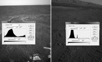
I'd like to start out with a comment about raw image contrast. There have been several postings in the main threads about whether or not the MSL raw images have been stretched like those from the MER missions. I am certainly no expert on this, but it looks to me as if the MSL images have not been stretched at all. I haven't tried to analyze all of the image types, but the hazcams and navcams have pixel brightness histograms that are very different from their MER counterparts. This attached image compares MER and MSL navcams along with their luminosity histograms.
The MSL images clearly are not using the entire, available range of brightness values, whereas the MER raws do. For this reason, the MSL raw images can usually be nicely enhanced by simply stretching the distribution of brightness across the full 256 value range. -------------------- ...Tom
I'm not a Space Fan, I'm a Space Exploration Enthusiast. |
|
 |
 
|
|
 |
|
Sep 18 2012, 10:43 PM
Post
#2
|
|
 Member Group: Members Posts: 222 Joined: 7-August 12 From: Garberville, CA Member No.: 6500 |
Hopefully what we're seeing has been temporarily utilized for a specific purpose, but if not...
QUOTE (Ant103 @ Sep 18 2012, 08:41 AM)  What has been lost, has been lost..... Aaarg so true.... over or under saturation cannot be recovered, period. But it's the disruption of the gray level relationships that's most lamentable to me because that's where much of the textural subtleties and thus potentially valuable scientific comparatives reside. I'm not a trained geologist, but even from an armchair perspective, for a particular rock or patch of soil, slight differences in the average nominal gray levels is often the key to identifying similar or disparate specimens and helps in theorizing their inherent characteristics and relationships. And of course the extreme halo effect overall will make seamless looking mosaics a nightmare. If the reasoning behind this is for the usability of the general public as suggested, perhaps some tweaking is part of the plan and we're seeing the first "extreme" test, after which I would hope that "toning down and tuning in" the level adjustment would be the next move. Hopefully there will be someone in the know here soon enough who can explain the rationale or temporal nature of what we're seeing a bit more. -------------------- "We shall not cease from exploration, and the end of all our exploring will be to arrive where we started and know the place for the first time." -T.S. Eliot
|
|
|
|
|
Sep 18 2012, 11:33 PM
Post
#3
|
|
 Senior Member Group: Members Posts: 4250 Joined: 17-January 05 Member No.: 152 |
FWIW, my guess is that jpl received masses of emails from the general public saying "these images are too dark". That's why the change. But now that the MSL engineering images look very similar to MER (I'm guessing it's the same algorithm), I doubt very much we'll see further "iterations". It's the masses screaming "too dark" they're reacting too; I'd be surprized if they bent over to tweak the stretching because a few of us complained about clipped whites. Remember that we were also loosing information in the old MSL images, them being effectively around 7 bits instead of 8.
QUOTE (EdTruthan @ Sep 18 2012, 10:43 PM) over or under saturation cannot be recovered, period ...until the images appear on PDS! It won't be that long...
|
|
|
|
 CosmicRocker MSL Images & Cameras Aug 16 2012, 11:05 PM
 djellison Blue filters on a bayer filter can often be nIR tr... Sep 16 2012, 07:04 AM Ant103 Oh nooo, what have they done ?
Auto-white balanc... Sep 18 2012, 01:57 PM
djellison Blue filters on a bayer filter can often be nIR tr... Sep 16 2012, 07:04 AM Ant103 Oh nooo, what have they done ?
Auto-white balanc... Sep 18 2012, 01:57 PM
 MahFL I don't know if it's me or what but the MS... Sep 18 2012, 02:02 PM dvandorn As one of the first people to mention that the nav... Sep 18 2012, 02:30 PM fredk QUOTE (dvandorn @ Sep 18 2012, 02:30 PM) ... Sep 18 2012, 03:14 PM mhoward Well, the Navcam image quality on the web improved... Sep 18 2012, 02:49 PM Ant103 Well yes, dark sand and over exposed rocks ?
http:... Sep 18 2012, 03:09 PM ronald QUOTE (Ant103 @ Sep 18 2012, 05:09 PM) I ... Sep 20 2012, 07:05 AM Ant103 No Fredk. What has been lost, has been lost. If yo... Sep 18 2012, 03:41 PM Doc I think you're right Ant. I study with B/W son... Sep 18 2012, 05:05 PM djellison QUOTE (Ant103 @ Sep 18 2012, 08:41 AM) bu... Sep 18 2012, 07:31 PM fredk You can reproduce the overall look of the old imag... Sep 18 2012, 06:14 PM Ant103 So, I could think that "people" have som... Sep 18 2012, 08:23 PM markril I'll just comment that I like the change (impr... Sep 19 2012, 01:19 AM Ant103 About 3 months if I'm correct ? Scuse me but, ... Sep 19 2012, 01:48 AM xflare QUOTE (Ant103 @ Sep 19 2012, 02:48 AM) Th... Sep 20 2012, 08:54 AM ronald Couldn't find an answer so far - can please so... Sep 20 2012, 07:48 PM mcaplinger QUOTE (ronald @ Sep 20 2012, 12:48 PM) ca... Sep 20 2012, 08:57 PM ronald Thank you for the link. Two more:
The combined Ca... Sep 21 2012, 06:09 AM vikingmars QUOTE (ronald @ Sep 21 2012, 08:09 AM) Th... Sep 23 2012, 11:50 AM djellison QUOTE (vikingmars @ Sep 23 2012, 03:50 AM... Sep 23 2012, 09:08 PM markril QUOTE (djellison @ Sep 23 2012, 02:08 PM)... Sep 23 2012, 09:31 PM vikingmars QUOTE (markril @ Sep 23 2012, 11:31 PM) I... Sep 24 2012, 10:19 AM Paul Fjeld QUOTE (vikingmars @ Sep 24 2012, 05:19 AM... Sep 24 2012, 03:09 PM udolein How can I demosaic the bayer filter treated Curios... Sep 22 2012, 01:17 PM Nix You can download GIMP (GIMP.org) and the plugin G... Sep 22 2012, 01:47 PM udolein Thanks-a-lot. Works !
Regards
Udo Sep 22 2012, 03:43 PM jmknapp How would the night sky look at Gale Crater? Would... Sep 22 2012, 08:10 PM Joffan QUOTE (jmknapp @ Sep 22 2012, 02:10 PM) I... Sep 22 2012, 08:42 PM ngunn I'll go with 'magnificent'. Dust isn... Sep 22 2012, 08:20 PM fredk There was lots of night imaging from Spirit of cou... Sep 22 2012, 09:40 PM markril QUOTE (fredk @ Sep 22 2012, 01:40 PM) As ... Sep 23 2012, 02:02 PM fredk The problem is precision. I'd be surprized if... Sep 23 2012, 04:51 PM jmknapp QUOTE (fredk @ Sep 23 2012, 12:51 PM) I... Sep 23 2012, 05:58 PM djellison Let's see if Mars behaves the same as that win... Sep 23 2012, 10:44 PM fredk The lighting's very different between those so... Sep 24 2012, 02:35 PM vikingmars QUOTE (fredk @ Sep 24 2012, 04:35 PM)
Th... Sep 24 2012, 03:46 PM djellison Note - you're not using calibrated data - you... Sep 24 2012, 04:52 PM jmknapp The date on that magnet study was June 2011, which... Sep 24 2012, 05:31 PM mcaplinger QUOTE (jmknapp @ Sep 24 2012, 10:31 AM) w... Sep 24 2012, 05:59 PM djellison Note that the thesis concludes that " in less... Sep 24 2012, 06:11 PM vikingmars QUOTE (djellison @ Sep 24 2012, 08:11 PM)... Sep 24 2012, 10:32 PM ronatu QUOTE (djellison @ Sep 24 2012, 02:11 PM)... Sep 24 2012, 11:53 PM iMPREPREX There appears to be dust on the right MastCam acco... Sep 26 2012, 06:50 AM Explorer1 Do you mean the little fleck on the middle top of ... Sep 26 2012, 07:31 AM xflare QUOTE (Explorer1 @ Sep 26 2012, 08:31 AM)... Sep 26 2012, 08:49 AM mhoward I haven't noticed any decrease in quality of t... Sep 26 2012, 12:03 PM vikingmars 100% agree with you ! They are great workable ... Sep 26 2012, 12:25 PM mcaplinger QUOTE (Explorer1 @ Sep 26 2012, 12:31 AM)... Sep 26 2012, 01:20 PM iMPREPREX QUOTE (mcaplinger @ Sep 26 2012, 08:20 AM... Sep 26 2012, 08:09 PM Deimos Remember that the Mastcam images are downlinked to... Sep 26 2012, 01:05 PM pospa Please don't lapidate me and excuse for mayb... Sep 26 2012, 02:44 PM fredk We talked about nighttime observing with MSL just ... Sep 26 2012, 02:54 PM pospa Thanks, fredk. I'm at UMSF almost daily but th... Sep 26 2012, 04:07 PM Greenish I don't post much but am a daily reader of thi... Oct 10 2012, 05:12 PM mcaplinger 1 doesn't apply, there have been lots of narro... Oct 10 2012, 05:55 PM ronald I did made some tests but the false colored (using... Oct 10 2012, 07:05 PM Greenish Thanks for the replies. I had overlooked the gray... Oct 10 2012, 10:17 PM mcaplinger QUOTE (Greenish @ Oct 10 2012, 03:17 PM) ... Oct 11 2012, 03:46 AM Greenish Thanks again, mcaplinger, for the clarification an... Oct 11 2012, 02:42 PM mcaplinger I've seen quite a bit of difference in how peo... Oct 14 2012, 03:25 PM ronald QUOTE (mcaplinger @ Oct 14 2012, 05:25 PM... Oct 14 2012, 06:09 PM ugordan QUOTE (ronald @ Oct 14 2012, 08:09 PM) So... Oct 14 2012, 06:53 PM Eyesonmars QUOTE (ugordan @ Oct 14 2012, 07:53 PM) N... Oct 14 2012, 09:23 PM AndyG QUOTE (Eyesonmars @ Oct 14 2012, 10:23 PM... Oct 14 2012, 11:24 PM ronald QUOTE (AndyG @ Oct 15 2012, 01:24 AM) My ... Oct 15 2012, 08:56 AM mcaplinger QUOTE (ronald @ Oct 14 2012, 11:09 AM) I ... Oct 14 2012, 07:15 PM ronald QUOTE (mcaplinger @ Oct 14 2012, 09:15 PM... Oct 14 2012, 07:56 PM mcaplinger QUOTE (ronald @ Oct 14 2012, 12:56 PM) So... Oct 14 2012, 08:32 PM DDAVIS Unfortunately this article is behind a paywall, bu... Oct 14 2012, 09:05 PM vikingmars QUOTE (DDAVIS @ Oct 14 2012, 11:05 PM) - ... Oct 14 2012, 11:11 PM Zeke4ther That definitely looks better. The black strut loo... Oct 14 2012, 05:25 PM Deimos I tend to be more on the side of expecting the sky... Oct 14 2012, 10:40 PM ngunn QUOTE (Deimos @ Oct 14 2012, 11:40 PM) On... Oct 14 2012, 11:00 PM stevesliva QUOTE (Deimos @ Oct 14 2012, 06:40 PM) Th... Oct 14 2012, 11:39 PM mcaplinger QUOTE (Deimos @ Oct 14 2012, 03:40 PM) Un... Oct 15 2012, 04:45 AM Deimos Smith & Lemmon 1999 (MPF special issue) talks ... Oct 15 2012, 08:32 AM mcaplinger QUOTE (Deimos @ Oct 15 2012, 01:32 AM) Sm... Oct 15 2012, 04:55 PM vikingmars QUOTE (Deimos @ Oct 15 2012, 12:40 AM) I ... Oct 16 2012, 08:26 AM EdTruthan Sorry for the long post but if this works as a fai... Oct 15 2012, 07:26 PM mcaplinger QUOTE (EdTruthan @ Oct 15 2012, 12:26 PM)... Oct 15 2012, 08:34 PM EdTruthan QUOTE (mcaplinger @ Oct 15 2012, 01:34 PM... Oct 16 2012, 02:38 AM ngunn It looks (on my monitor, to my eyes, adjusted to c... Oct 15 2012, 08:46 PM ronald With Deimos arguments above (40:60 - sky:sun) we a... Oct 15 2012, 08:49 PM atomoid the calibration target is looking pretty dusty alr... Oct 16 2012, 12:08 AM mcaplinger QUOTE (atomoid @ Oct 15 2012, 05:08 PM) t... Oct 16 2012, 12:22 AM ronald I'm still somewhat puzzled with the brightness... Oct 18 2012, 10:42 AM Ant103 Ronald, you just can't made deduction starting... Oct 18 2012, 11:07 AM mcaplinger QUOTE (Ant103 @ Oct 18 2012, 04:07 AM) So... Oct 18 2012, 04:12 PM ronald Absolutely right regarding percieved brightness an... Oct 18 2012, 05:21 PM atomoid Ronald's links reveal the shadows depict the s... Oct 19 2012, 12:24 AM fredk QUOTE (mcaplinger @ Oct 18 2012, 04:12 PM... Oct 18 2012, 05:56 PM mcaplinger QUOTE (fredk @ Oct 18 2012, 10:56 AM) Wha... Oct 19 2012, 05:57 AM ronald I can
Even on the now stretched image above t... Oct 18 2012, 01:05 PM ugordan Mastcam images should be your reference point, not... Oct 18 2012, 02:49 PM
MahFL I don't know if it's me or what but the MS... Sep 18 2012, 02:02 PM dvandorn As one of the first people to mention that the nav... Sep 18 2012, 02:30 PM fredk QUOTE (dvandorn @ Sep 18 2012, 02:30 PM) ... Sep 18 2012, 03:14 PM mhoward Well, the Navcam image quality on the web improved... Sep 18 2012, 02:49 PM Ant103 Well yes, dark sand and over exposed rocks ?
http:... Sep 18 2012, 03:09 PM ronald QUOTE (Ant103 @ Sep 18 2012, 05:09 PM) I ... Sep 20 2012, 07:05 AM Ant103 No Fredk. What has been lost, has been lost. If yo... Sep 18 2012, 03:41 PM Doc I think you're right Ant. I study with B/W son... Sep 18 2012, 05:05 PM djellison QUOTE (Ant103 @ Sep 18 2012, 08:41 AM) bu... Sep 18 2012, 07:31 PM fredk You can reproduce the overall look of the old imag... Sep 18 2012, 06:14 PM Ant103 So, I could think that "people" have som... Sep 18 2012, 08:23 PM markril I'll just comment that I like the change (impr... Sep 19 2012, 01:19 AM Ant103 About 3 months if I'm correct ? Scuse me but, ... Sep 19 2012, 01:48 AM xflare QUOTE (Ant103 @ Sep 19 2012, 02:48 AM) Th... Sep 20 2012, 08:54 AM ronald Couldn't find an answer so far - can please so... Sep 20 2012, 07:48 PM mcaplinger QUOTE (ronald @ Sep 20 2012, 12:48 PM) ca... Sep 20 2012, 08:57 PM ronald Thank you for the link. Two more:
The combined Ca... Sep 21 2012, 06:09 AM vikingmars QUOTE (ronald @ Sep 21 2012, 08:09 AM) Th... Sep 23 2012, 11:50 AM djellison QUOTE (vikingmars @ Sep 23 2012, 03:50 AM... Sep 23 2012, 09:08 PM markril QUOTE (djellison @ Sep 23 2012, 02:08 PM)... Sep 23 2012, 09:31 PM vikingmars QUOTE (markril @ Sep 23 2012, 11:31 PM) I... Sep 24 2012, 10:19 AM Paul Fjeld QUOTE (vikingmars @ Sep 24 2012, 05:19 AM... Sep 24 2012, 03:09 PM udolein How can I demosaic the bayer filter treated Curios... Sep 22 2012, 01:17 PM Nix You can download GIMP (GIMP.org) and the plugin G... Sep 22 2012, 01:47 PM udolein Thanks-a-lot. Works !
Regards
Udo Sep 22 2012, 03:43 PM jmknapp How would the night sky look at Gale Crater? Would... Sep 22 2012, 08:10 PM Joffan QUOTE (jmknapp @ Sep 22 2012, 02:10 PM) I... Sep 22 2012, 08:42 PM ngunn I'll go with 'magnificent'. Dust isn... Sep 22 2012, 08:20 PM fredk There was lots of night imaging from Spirit of cou... Sep 22 2012, 09:40 PM markril QUOTE (fredk @ Sep 22 2012, 01:40 PM) As ... Sep 23 2012, 02:02 PM fredk The problem is precision. I'd be surprized if... Sep 23 2012, 04:51 PM jmknapp QUOTE (fredk @ Sep 23 2012, 12:51 PM) I... Sep 23 2012, 05:58 PM djellison Let's see if Mars behaves the same as that win... Sep 23 2012, 10:44 PM fredk The lighting's very different between those so... Sep 24 2012, 02:35 PM vikingmars QUOTE (fredk @ Sep 24 2012, 04:35 PM)
Th... Sep 24 2012, 03:46 PM djellison Note - you're not using calibrated data - you... Sep 24 2012, 04:52 PM jmknapp The date on that magnet study was June 2011, which... Sep 24 2012, 05:31 PM mcaplinger QUOTE (jmknapp @ Sep 24 2012, 10:31 AM) w... Sep 24 2012, 05:59 PM djellison Note that the thesis concludes that " in less... Sep 24 2012, 06:11 PM vikingmars QUOTE (djellison @ Sep 24 2012, 08:11 PM)... Sep 24 2012, 10:32 PM ronatu QUOTE (djellison @ Sep 24 2012, 02:11 PM)... Sep 24 2012, 11:53 PM iMPREPREX There appears to be dust on the right MastCam acco... Sep 26 2012, 06:50 AM Explorer1 Do you mean the little fleck on the middle top of ... Sep 26 2012, 07:31 AM xflare QUOTE (Explorer1 @ Sep 26 2012, 08:31 AM)... Sep 26 2012, 08:49 AM mhoward I haven't noticed any decrease in quality of t... Sep 26 2012, 12:03 PM vikingmars 100% agree with you ! They are great workable ... Sep 26 2012, 12:25 PM mcaplinger QUOTE (Explorer1 @ Sep 26 2012, 12:31 AM)... Sep 26 2012, 01:20 PM iMPREPREX QUOTE (mcaplinger @ Sep 26 2012, 08:20 AM... Sep 26 2012, 08:09 PM Deimos Remember that the Mastcam images are downlinked to... Sep 26 2012, 01:05 PM pospa Please don't lapidate me and excuse for mayb... Sep 26 2012, 02:44 PM fredk We talked about nighttime observing with MSL just ... Sep 26 2012, 02:54 PM pospa Thanks, fredk. I'm at UMSF almost daily but th... Sep 26 2012, 04:07 PM Greenish I don't post much but am a daily reader of thi... Oct 10 2012, 05:12 PM mcaplinger 1 doesn't apply, there have been lots of narro... Oct 10 2012, 05:55 PM ronald I did made some tests but the false colored (using... Oct 10 2012, 07:05 PM Greenish Thanks for the replies. I had overlooked the gray... Oct 10 2012, 10:17 PM mcaplinger QUOTE (Greenish @ Oct 10 2012, 03:17 PM) ... Oct 11 2012, 03:46 AM Greenish Thanks again, mcaplinger, for the clarification an... Oct 11 2012, 02:42 PM mcaplinger I've seen quite a bit of difference in how peo... Oct 14 2012, 03:25 PM ronald QUOTE (mcaplinger @ Oct 14 2012, 05:25 PM... Oct 14 2012, 06:09 PM ugordan QUOTE (ronald @ Oct 14 2012, 08:09 PM) So... Oct 14 2012, 06:53 PM Eyesonmars QUOTE (ugordan @ Oct 14 2012, 07:53 PM) N... Oct 14 2012, 09:23 PM AndyG QUOTE (Eyesonmars @ Oct 14 2012, 10:23 PM... Oct 14 2012, 11:24 PM ronald QUOTE (AndyG @ Oct 15 2012, 01:24 AM) My ... Oct 15 2012, 08:56 AM mcaplinger QUOTE (ronald @ Oct 14 2012, 11:09 AM) I ... Oct 14 2012, 07:15 PM ronald QUOTE (mcaplinger @ Oct 14 2012, 09:15 PM... Oct 14 2012, 07:56 PM mcaplinger QUOTE (ronald @ Oct 14 2012, 12:56 PM) So... Oct 14 2012, 08:32 PM DDAVIS Unfortunately this article is behind a paywall, bu... Oct 14 2012, 09:05 PM vikingmars QUOTE (DDAVIS @ Oct 14 2012, 11:05 PM) - ... Oct 14 2012, 11:11 PM Zeke4ther That definitely looks better. The black strut loo... Oct 14 2012, 05:25 PM Deimos I tend to be more on the side of expecting the sky... Oct 14 2012, 10:40 PM ngunn QUOTE (Deimos @ Oct 14 2012, 11:40 PM) On... Oct 14 2012, 11:00 PM stevesliva QUOTE (Deimos @ Oct 14 2012, 06:40 PM) Th... Oct 14 2012, 11:39 PM mcaplinger QUOTE (Deimos @ Oct 14 2012, 03:40 PM) Un... Oct 15 2012, 04:45 AM Deimos Smith & Lemmon 1999 (MPF special issue) talks ... Oct 15 2012, 08:32 AM mcaplinger QUOTE (Deimos @ Oct 15 2012, 01:32 AM) Sm... Oct 15 2012, 04:55 PM vikingmars QUOTE (Deimos @ Oct 15 2012, 12:40 AM) I ... Oct 16 2012, 08:26 AM EdTruthan Sorry for the long post but if this works as a fai... Oct 15 2012, 07:26 PM mcaplinger QUOTE (EdTruthan @ Oct 15 2012, 12:26 PM)... Oct 15 2012, 08:34 PM EdTruthan QUOTE (mcaplinger @ Oct 15 2012, 01:34 PM... Oct 16 2012, 02:38 AM ngunn It looks (on my monitor, to my eyes, adjusted to c... Oct 15 2012, 08:46 PM ronald With Deimos arguments above (40:60 - sky:sun) we a... Oct 15 2012, 08:49 PM atomoid the calibration target is looking pretty dusty alr... Oct 16 2012, 12:08 AM mcaplinger QUOTE (atomoid @ Oct 15 2012, 05:08 PM) t... Oct 16 2012, 12:22 AM ronald I'm still somewhat puzzled with the brightness... Oct 18 2012, 10:42 AM Ant103 Ronald, you just can't made deduction starting... Oct 18 2012, 11:07 AM mcaplinger QUOTE (Ant103 @ Oct 18 2012, 04:07 AM) So... Oct 18 2012, 04:12 PM ronald Absolutely right regarding percieved brightness an... Oct 18 2012, 05:21 PM atomoid Ronald's links reveal the shadows depict the s... Oct 19 2012, 12:24 AM fredk QUOTE (mcaplinger @ Oct 18 2012, 04:12 PM... Oct 18 2012, 05:56 PM mcaplinger QUOTE (fredk @ Oct 18 2012, 10:56 AM) Wha... Oct 19 2012, 05:57 AM ronald I can
Even on the now stretched image above t... Oct 18 2012, 01:05 PM ugordan Mastcam images should be your reference point, not... Oct 18 2012, 02:49 PM |

|
Lo-Fi Version | Time is now: 4th June 2024 - 10:49 PM |
|
RULES AND GUIDELINES Please read the Forum Rules and Guidelines before posting. IMAGE COPYRIGHT |
OPINIONS AND MODERATION Opinions expressed on UnmannedSpaceflight.com are those of the individual posters and do not necessarily reflect the opinions of UnmannedSpaceflight.com or The Planetary Society. The all-volunteer UnmannedSpaceflight.com moderation team is wholly independent of The Planetary Society. The Planetary Society has no influence over decisions made by the UnmannedSpaceflight.com moderators. |
SUPPORT THE FORUM Unmannedspaceflight.com is funded by the Planetary Society. Please consider supporting our work and many other projects by donating to the Society or becoming a member. |
|