Geomorphology of Gale Crater, Rock on! |

Geomorphology of Gale Crater, Rock on! |
 Sep 26 2012, 10:22 PM Sep 26 2012, 10:22 PM
Post
#1
|
|
|
Senior Member  Group: Members Posts: 3516 Joined: 4-November 05 From: North Wales Member No.: 542 |
I'd like a discussion thread about the geology detatched from the time limits of current MSL threads. We had a 'Geomorphology of Cape York' thread that attracted a lot of interesting posts. How about 'Geomorphology of Gale Crater'? I have one or two ideas but many more questions, and I'd like to post them in a longer-running thread away from the day to day imaging discussion. Any other takers?
For starters, does anybody have a contour map of this place like the one at Meridiani with 5m intervals? ADMIN: You have your wishes fulfilled on UMSF (sometimes) 
|
 |
 
|
 |
|
Oct 8 2012, 04:16 PM
Post
#2
|
||
|
Junior Member Group: Members Posts: 59 Joined: 18-July 07 From: London, UK Member No.: 2873 |
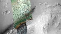
After a few requests, I've made some base maps of Gale and the Bradbury Landing site at a few different zoom levels.
They're all linked over here, with a bit of an accompanying explanation. A scaled down example of what's there:
Hopefully they might be of some use in discussions like those above. Pete |
|
|
|
|
|
 ngunn Geomorphology of Gale Crater Sep 26 2012, 10:22 PM
 Eyesonmars I'm a little confused about the layers on Mt. ... Sep 27 2012, 12:42 AM Ondaweb QUOTE (ngunn @ Sep 26 2012, 05:22 PM) How... Sep 27 2012, 01:25 AM Phil Stooke Sediment settling out of a fluid onto a flat surfa... Sep 27 2012, 01:25 AM dvandorn One rim of Gale Crater is quite a bit higher above... Sep 27 2012, 03:16 AM Explorer1 Could we figure out a ballpark estimate for the si... Sep 27 2012, 03:20 AM serpens Great idea ngunn.
To appreciate the variations in... Sep 27 2012, 04:34 AM ngunn (Thanks admin )
I have been wondering about the ... Sep 27 2012, 07:39 AM jmknapp The operative sentence from the Anderson/Bell pape... Sep 27 2012, 10:11 AM ngunn Also in that paper (pp107-8) is discussion of the ... Sep 27 2012, 06:03 PM Chmee Great idea for this thread.
Since there is no obvi... Sep 27 2012, 08:25 PM
Eyesonmars I'm a little confused about the layers on Mt. ... Sep 27 2012, 12:42 AM Ondaweb QUOTE (ngunn @ Sep 26 2012, 05:22 PM) How... Sep 27 2012, 01:25 AM Phil Stooke Sediment settling out of a fluid onto a flat surfa... Sep 27 2012, 01:25 AM dvandorn One rim of Gale Crater is quite a bit higher above... Sep 27 2012, 03:16 AM Explorer1 Could we figure out a ballpark estimate for the si... Sep 27 2012, 03:20 AM serpens Great idea ngunn.
To appreciate the variations in... Sep 27 2012, 04:34 AM ngunn (Thanks admin )
I have been wondering about the ... Sep 27 2012, 07:39 AM jmknapp The operative sentence from the Anderson/Bell pape... Sep 27 2012, 10:11 AM ngunn Also in that paper (pp107-8) is discussion of the ... Sep 27 2012, 06:03 PM Chmee Great idea for this thread.
Since there is no obvi... Sep 27 2012, 08:25 PM
 djellison QUOTE (Chmee @ Sep 27 2012, 01:25 PM) Sin... Sep 27 2012, 08:30 PM ngunn Add to that the possibility of quite a lot of ice ... Sep 27 2012, 08:45 PM Eyesonmars Also note that Curiosity is sitting on or very nea... Sep 27 2012, 09:16 PM serpens QUOTE (Eyesonmars @ Sep 27 2012, 10:16 PM... Sep 28 2012, 05:10 AM Eyesonmars QUOTE (serpens @ Sep 28 2012, 05:10 AM) N... Sep 28 2012, 01:18 PM atomoid QUOTE (Eyesonmars @ Sep 27 2012, 02:16 PM... Sep 29 2012, 01:34 AM dvandorn QUOTE (atomoid @ Sep 28 2012, 08:34 PM) i... Sep 29 2012, 02:36 AM fthurber QUOTE (dvandorn @ Sep 28 2012, 10:36 PM) ... Oct 1 2012, 01:47 AM Don1 Anybody like the idea of a mud volcano for Mt Shar... Sep 28 2012, 05:48 AM xflare What kind of theories and ideas are floating aroun... Sep 28 2012, 08:41 AM ngunn See the discussion I referred to in post 10 for st... Sep 28 2012, 10:46 AM Art Martin I'm having a hard time reconciling from the ne... Sep 28 2012, 08:01 PM ngunn QUOTE (Art Martin @ Sep 28 2012, 09:01 PM... Sep 28 2012, 08:05 PM Phil Stooke Art, Mt Sharp runs all around the south horizon fr... Sep 28 2012, 08:08 PM elakdawalla I made this two days ago -- it's an un-polar p... Sep 28 2012, 08:08 PM ngunn QUOTE (elakdawalla @ Sep 28 2012, 09:08 P... Sep 28 2012, 09:40 PM Art Martin Thanks, so much clearer now. I just had no idea o... Sep 28 2012, 08:41 PM elakdawalla That is precisely what I was using it for. Don... Sep 28 2012, 10:17 PM fthurber QUOTE (elakdawalla @ Sep 28 2012, 06:17 P... Sep 28 2012, 10:57 PM elakdawalla Here you go. Attached version is 3600 pixels wide ... Sep 29 2012, 12:15 AM drz1111 A question about redox and sedimentary paleoenviro... Oct 1 2012, 05:59 PM elakdawalla Re: Hottah, that's a good question, and there ... Oct 1 2012, 07:03 PM Eyesonmars The area Curiosity has been traversing has quite a... Oct 1 2012, 08:50 PM drz1111 QUOTE (elakdawalla @ Oct 1 2012, 03:03 PM... Oct 1 2012, 09:11 PM ngunn Eyesonmars: Interesting question. Here's an of... Oct 1 2012, 09:31 PM Eyesonmars QUOTE (ngunn @ Oct 1 2012, 09:31 PM) Like... Oct 2 2012, 07:41 PM ngunn I've just come across this detailed thermal in... Oct 4 2012, 08:39 PM djellison Yes - the full size is here : http://www.nasa.gov/... Oct 4 2012, 09:34 PM ngunn Brilliant! Thanks Doug. While you're on th... Oct 4 2012, 09:56 PM djellison Contour - no - but there is this - http://photojou... Oct 4 2012, 10:10 PM ngunn That's good, and there's also this:
http:/... Oct 4 2012, 10:30 PM Eyesonmars True. But even at 100 meters/pixel you can just ma... Oct 4 2012, 11:12 PM elakdawalla Peter Grindrod has a good blog entry on this topic... Oct 4 2012, 11:17 PM ngunn Just what I was looking for, thanks Emily. Oct 5 2012, 08:48 AM ngunn I am particularly intrigued by the enclosed depres... Oct 6 2012, 09:30 AM Eyesonmars QUOTE (ngunn @ Oct 6 2012, 10:30 AM) I am... Oct 6 2012, 07:26 PM ngunn It's fun to look at those craterlets and imagi... Oct 6 2012, 08:53 PM Eyesonmars I agree. It is great fun to try to imagine process... Oct 6 2012, 09:08 PM serpens QUOTE (Eyesonmars @ Oct 6 2012, 09:08 PM)... Oct 7 2012, 03:22 AM ngunn QUOTE (serpens @ Oct 7 2012, 04:22 AM) Th... Oct 7 2012, 07:40 AM Eyesonmars Also - as you queried - Where is the water flowing... Oct 6 2012, 09:30 PM ngunn QUOTE (Eyesonmars @ Oct 6 2012, 10:30 PM)... Oct 6 2012, 10:12 PM Ondaweb QUOTE (Eyesonmars @ Oct 6 2012, 04:30 PM)... Oct 7 2012, 09:30 PM Fran Ontanaya Mmh, is the assumed order of events: 1) the last s... Oct 7 2012, 08:59 AM serpens The filled then excavated crater hypothesis seems ... Oct 7 2012, 02:00 PM ngunn There are contours derived from CTX by Peter Grind... Oct 7 2012, 09:51 PM ngunn Extremely helpful and much, much appreciated. Oct 8 2012, 07:10 PM Ondaweb Thanks Pete, very helpful indeed. One of the thin... Oct 9 2012, 01:23 AM jmknapp A paper from the MSL team to be delivered at the G... Oct 16 2012, 02:30 AM Stellingwerff Hi Joe,
I think you are slightly too high up the ... Oct 16 2012, 05:34 AM CosmicRocker QUOTE (jmknapp @ Oct 15 2012, 08:30 PM) A... Oct 16 2012, 06:16 AM jmknapp Ludo, thanks for that--looks like a good inference... Oct 16 2012, 11:24 AM Zelenyikot Greetings from Russia
I want to share my obser... Nov 5 2012, 05:24 AM acastillo Hi, my first post.
The problem with a volcanic in... Nov 5 2012, 06:06 PM dvandorn QUOTE (Phil Stooke @ Nov 28 2012, 03:37 P... Nov 28 2012, 04:35 PM elakdawalla One feature very common to Gale crater, both its f... Nov 28 2012, 04:48 PM ddan QUOTE (elakdawalla @ Nov 28 2012, 11:48 A... Nov 28 2012, 05:12 PM mcaplinger QUOTE (ddan @ Nov 28 2012, 10:12 AM) One ... Nov 28 2012, 06:25 PM SteveM The uniformitarian in me gets nervous when I read ... Nov 28 2012, 08:08 PM serpens QUOTE (SteveM @ Nov 28 2012, 09:08 PM) Th... Nov 29 2012, 09:13 PM Chmee QUOTE (mcaplinger @ Nov 28 2012, 01:25 PM... Nov 29 2012, 06:45 PM Phil Stooke At some point if the debris breaks down into suffi... Nov 28 2012, 05:41 PM ngunn It's a great phrase isn't it? Get's yo... Nov 28 2012, 08:27 PM Actionman QUOTE (ngunn @ Nov 28 2012, 03:27 PM) Wit... Nov 29 2012, 01:10 PM Zelenyikot My thought involves this element. It looks as a wa... Nov 29 2012, 02:52 AM djellison Are you suggesting that Mt Sharp is just a pile of... Nov 29 2012, 03:02 PM Actionman yes, maybe
glacial cone/funnel
Some evidence woul... Nov 29 2012, 05:41 PM Phil Stooke There is plenty of evidence for glaciers elsewhere... Nov 29 2012, 05:50 PM Actionman It's a cinch we're not going to be finding... Nov 30 2012, 12:20 AM djellison QUOTE (Actionman @ Nov 29 2012, 04:20 PM)... Nov 30 2012, 12:36 AM centsworth_II QUOTE (Actionman @ Nov 29 2012, 07:20 PM)... Nov 30 2012, 02:34 AM elakdawalla QUOTE (Actionman @ Nov 29 2012, 04:20 PM)... Nov 30 2012, 05:50 AM Actionman I'm sorry elakda for making it sound too you l... Nov 30 2012, 12:13 PM centsworth_II QUOTE (Actionman @ Nov 30 2012, 07:13 AM)... Nov 30 2012, 01:45 PM djellison QUOTE (Actionman @ Nov 30 2012, 04:13 AM)... Nov 30 2012, 04:36 PM ngunn I think the term you want is 'basement rock... Nov 30 2012, 12:43 PM Stellingwerff QUOTE We see chucks of basalt everywhere BUT what ... Nov 30 2012, 01:04 PM Actionman And thank you Ludo.
Make it so Nov 30 2012, 01:14 PM Ant103 Can I ask something ? Not very important, but for ... Nov 30 2012, 05:46 PM djellison QUOTE (Ant103 @ Nov 30 2012, 09:46 AM) Ca... Nov 30 2012, 06:01 PM ElkGroveDan Not a good idea. The science of geology is what i... Nov 30 2012, 05:54 PM Actionman In this GIF from the above Mr. Anderson and James ... Nov 30 2012, 05:54 PM djellison QUOTE (Actionman @ Nov 30 2012, 09:54 AM)... Nov 30 2012, 06:16 PM Ant103 Okay, I understand totaly I was just asking. It... Nov 30 2012, 06:06 PM Actionman Basal and basalt are important distinctions both o... Nov 30 2012, 06:38 PM djellison You can not scatter 'basal' on the surface... Nov 30 2012, 06:44 PM ngunn With the Anderson and Bell diagram easily to hand ... Nov 30 2012, 07:09 PM djellison We're (I think) in the area where the HP, HTIF... Nov 30 2012, 07:14 PM
djellison QUOTE (Chmee @ Sep 27 2012, 01:25 PM) Sin... Sep 27 2012, 08:30 PM ngunn Add to that the possibility of quite a lot of ice ... Sep 27 2012, 08:45 PM Eyesonmars Also note that Curiosity is sitting on or very nea... Sep 27 2012, 09:16 PM serpens QUOTE (Eyesonmars @ Sep 27 2012, 10:16 PM... Sep 28 2012, 05:10 AM Eyesonmars QUOTE (serpens @ Sep 28 2012, 05:10 AM) N... Sep 28 2012, 01:18 PM atomoid QUOTE (Eyesonmars @ Sep 27 2012, 02:16 PM... Sep 29 2012, 01:34 AM dvandorn QUOTE (atomoid @ Sep 28 2012, 08:34 PM) i... Sep 29 2012, 02:36 AM fthurber QUOTE (dvandorn @ Sep 28 2012, 10:36 PM) ... Oct 1 2012, 01:47 AM Don1 Anybody like the idea of a mud volcano for Mt Shar... Sep 28 2012, 05:48 AM xflare What kind of theories and ideas are floating aroun... Sep 28 2012, 08:41 AM ngunn See the discussion I referred to in post 10 for st... Sep 28 2012, 10:46 AM Art Martin I'm having a hard time reconciling from the ne... Sep 28 2012, 08:01 PM ngunn QUOTE (Art Martin @ Sep 28 2012, 09:01 PM... Sep 28 2012, 08:05 PM Phil Stooke Art, Mt Sharp runs all around the south horizon fr... Sep 28 2012, 08:08 PM elakdawalla I made this two days ago -- it's an un-polar p... Sep 28 2012, 08:08 PM ngunn QUOTE (elakdawalla @ Sep 28 2012, 09:08 P... Sep 28 2012, 09:40 PM Art Martin Thanks, so much clearer now. I just had no idea o... Sep 28 2012, 08:41 PM elakdawalla That is precisely what I was using it for. Don... Sep 28 2012, 10:17 PM fthurber QUOTE (elakdawalla @ Sep 28 2012, 06:17 P... Sep 28 2012, 10:57 PM elakdawalla Here you go. Attached version is 3600 pixels wide ... Sep 29 2012, 12:15 AM drz1111 A question about redox and sedimentary paleoenviro... Oct 1 2012, 05:59 PM elakdawalla Re: Hottah, that's a good question, and there ... Oct 1 2012, 07:03 PM Eyesonmars The area Curiosity has been traversing has quite a... Oct 1 2012, 08:50 PM drz1111 QUOTE (elakdawalla @ Oct 1 2012, 03:03 PM... Oct 1 2012, 09:11 PM ngunn Eyesonmars: Interesting question. Here's an of... Oct 1 2012, 09:31 PM Eyesonmars QUOTE (ngunn @ Oct 1 2012, 09:31 PM) Like... Oct 2 2012, 07:41 PM ngunn I've just come across this detailed thermal in... Oct 4 2012, 08:39 PM djellison Yes - the full size is here : http://www.nasa.gov/... Oct 4 2012, 09:34 PM ngunn Brilliant! Thanks Doug. While you're on th... Oct 4 2012, 09:56 PM djellison Contour - no - but there is this - http://photojou... Oct 4 2012, 10:10 PM ngunn That's good, and there's also this:
http:/... Oct 4 2012, 10:30 PM Eyesonmars True. But even at 100 meters/pixel you can just ma... Oct 4 2012, 11:12 PM elakdawalla Peter Grindrod has a good blog entry on this topic... Oct 4 2012, 11:17 PM ngunn Just what I was looking for, thanks Emily. Oct 5 2012, 08:48 AM ngunn I am particularly intrigued by the enclosed depres... Oct 6 2012, 09:30 AM Eyesonmars QUOTE (ngunn @ Oct 6 2012, 10:30 AM) I am... Oct 6 2012, 07:26 PM ngunn It's fun to look at those craterlets and imagi... Oct 6 2012, 08:53 PM Eyesonmars I agree. It is great fun to try to imagine process... Oct 6 2012, 09:08 PM serpens QUOTE (Eyesonmars @ Oct 6 2012, 09:08 PM)... Oct 7 2012, 03:22 AM ngunn QUOTE (serpens @ Oct 7 2012, 04:22 AM) Th... Oct 7 2012, 07:40 AM Eyesonmars Also - as you queried - Where is the water flowing... Oct 6 2012, 09:30 PM ngunn QUOTE (Eyesonmars @ Oct 6 2012, 10:30 PM)... Oct 6 2012, 10:12 PM Ondaweb QUOTE (Eyesonmars @ Oct 6 2012, 04:30 PM)... Oct 7 2012, 09:30 PM Fran Ontanaya Mmh, is the assumed order of events: 1) the last s... Oct 7 2012, 08:59 AM serpens The filled then excavated crater hypothesis seems ... Oct 7 2012, 02:00 PM ngunn There are contours derived from CTX by Peter Grind... Oct 7 2012, 09:51 PM ngunn Extremely helpful and much, much appreciated. Oct 8 2012, 07:10 PM Ondaweb Thanks Pete, very helpful indeed. One of the thin... Oct 9 2012, 01:23 AM jmknapp A paper from the MSL team to be delivered at the G... Oct 16 2012, 02:30 AM Stellingwerff Hi Joe,
I think you are slightly too high up the ... Oct 16 2012, 05:34 AM CosmicRocker QUOTE (jmknapp @ Oct 15 2012, 08:30 PM) A... Oct 16 2012, 06:16 AM jmknapp Ludo, thanks for that--looks like a good inference... Oct 16 2012, 11:24 AM Zelenyikot Greetings from Russia
I want to share my obser... Nov 5 2012, 05:24 AM acastillo Hi, my first post.
The problem with a volcanic in... Nov 5 2012, 06:06 PM dvandorn QUOTE (Phil Stooke @ Nov 28 2012, 03:37 P... Nov 28 2012, 04:35 PM elakdawalla One feature very common to Gale crater, both its f... Nov 28 2012, 04:48 PM ddan QUOTE (elakdawalla @ Nov 28 2012, 11:48 A... Nov 28 2012, 05:12 PM mcaplinger QUOTE (ddan @ Nov 28 2012, 10:12 AM) One ... Nov 28 2012, 06:25 PM SteveM The uniformitarian in me gets nervous when I read ... Nov 28 2012, 08:08 PM serpens QUOTE (SteveM @ Nov 28 2012, 09:08 PM) Th... Nov 29 2012, 09:13 PM Chmee QUOTE (mcaplinger @ Nov 28 2012, 01:25 PM... Nov 29 2012, 06:45 PM Phil Stooke At some point if the debris breaks down into suffi... Nov 28 2012, 05:41 PM ngunn It's a great phrase isn't it? Get's yo... Nov 28 2012, 08:27 PM Actionman QUOTE (ngunn @ Nov 28 2012, 03:27 PM) Wit... Nov 29 2012, 01:10 PM Zelenyikot My thought involves this element. It looks as a wa... Nov 29 2012, 02:52 AM djellison Are you suggesting that Mt Sharp is just a pile of... Nov 29 2012, 03:02 PM Actionman yes, maybe
glacial cone/funnel
Some evidence woul... Nov 29 2012, 05:41 PM Phil Stooke There is plenty of evidence for glaciers elsewhere... Nov 29 2012, 05:50 PM Actionman It's a cinch we're not going to be finding... Nov 30 2012, 12:20 AM djellison QUOTE (Actionman @ Nov 29 2012, 04:20 PM)... Nov 30 2012, 12:36 AM centsworth_II QUOTE (Actionman @ Nov 29 2012, 07:20 PM)... Nov 30 2012, 02:34 AM elakdawalla QUOTE (Actionman @ Nov 29 2012, 04:20 PM)... Nov 30 2012, 05:50 AM Actionman I'm sorry elakda for making it sound too you l... Nov 30 2012, 12:13 PM centsworth_II QUOTE (Actionman @ Nov 30 2012, 07:13 AM)... Nov 30 2012, 01:45 PM djellison QUOTE (Actionman @ Nov 30 2012, 04:13 AM)... Nov 30 2012, 04:36 PM ngunn I think the term you want is 'basement rock... Nov 30 2012, 12:43 PM Stellingwerff QUOTE We see chucks of basalt everywhere BUT what ... Nov 30 2012, 01:04 PM Actionman And thank you Ludo.
Make it so Nov 30 2012, 01:14 PM Ant103 Can I ask something ? Not very important, but for ... Nov 30 2012, 05:46 PM djellison QUOTE (Ant103 @ Nov 30 2012, 09:46 AM) Ca... Nov 30 2012, 06:01 PM ElkGroveDan Not a good idea. The science of geology is what i... Nov 30 2012, 05:54 PM Actionman In this GIF from the above Mr. Anderson and James ... Nov 30 2012, 05:54 PM djellison QUOTE (Actionman @ Nov 30 2012, 09:54 AM)... Nov 30 2012, 06:16 PM Ant103 Okay, I understand totaly I was just asking. It... Nov 30 2012, 06:06 PM Actionman Basal and basalt are important distinctions both o... Nov 30 2012, 06:38 PM djellison You can not scatter 'basal' on the surface... Nov 30 2012, 06:44 PM ngunn With the Anderson and Bell diagram easily to hand ... Nov 30 2012, 07:09 PM djellison We're (I think) in the area where the HP, HTIF... Nov 30 2012, 07:14 PM |

|
Lo-Fi Version | Time is now: 26th September 2024 - 04:05 PM |
|
RULES AND GUIDELINES Please read the Forum Rules and Guidelines before posting. IMAGE COPYRIGHT |
OPINIONS AND MODERATION Opinions expressed on UnmannedSpaceflight.com are those of the individual posters and do not necessarily reflect the opinions of UnmannedSpaceflight.com or The Planetary Society. The all-volunteer UnmannedSpaceflight.com moderation team is wholly independent of The Planetary Society. The Planetary Society has no influence over decisions made by the UnmannedSpaceflight.com moderators. |
SUPPORT THE FORUM Unmannedspaceflight.com is funded by the Planetary Society. Please consider supporting our work and many other projects by donating to the Society or becoming a member. |
|