Processed images from Earth orbiting spacecraft |

Processed images from Earth orbiting spacecraft |
 Nov 15 2012, 12:37 AM Nov 15 2012, 12:37 AM
Post
#1
|
||
 IMG to PNG GOD  Group: Moderator Posts: 2254 Joined: 19-February 04 From: Near fire and ice Member No.: 38 |
For some reason it didn't come to my attention until recently (less than a year ago) that the entire Landsat imagery plus a lot of data from other Earth orbiting spacecraft is freely available for download at http://earthexplorer.usgs.gov/ . Maybe this is because for a long time it was more difficult to find good and freely available global maps (or get data to make maps) of the Earth than it was for other planets/satellites - I somehow was under the impression that the vast majority of Earth imagery was commercial.
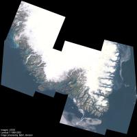
The Earth is visually a really spectacular planet (in my opinion possibly even the most photogenic body in the entire solar system) so it's possible to get spectacular results by downloading some of this data. The data can be selected by spacecraft, instrument, location, months/years, cloud cover percentage etc. Data is available from several Landsat satellites but the best data is from Landsat 7; Landsat 5 is also good. This is multispectral data with a resolution of 30 meters/pixel. Here is an experimental and spectacular 12 frame mosaic showing southern Greenland (10% the original size):
The full size version (19000 pixels square) plus additional information can be seen in this blog entry at the Planetary Society website. This image shows a spectacular and complex 'maze' of long and narrow fjords and islands, narrow valleys flanked by steep mountains, glaciers and glacial rivers, countless lakes and ponds and in general a landscape that has been shaped by advancing and retreating glaciers, depending on climate. One important thing to note is that overall this data turned out to be easier to process than is typical for data from other planets. |
|
 |
 
|
|
 |
|
Jun 8 2013, 06:15 PM
Post
#2
|
||
|
IMG to PNG GOD Group: Moderator Posts: 2254 Joined: 19-February 04 From: Near fire and ice Member No.: 38 |
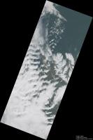
Landsat 8 was launched in February. Following a period of checkouts and calibrations it started regular operations in late May. Below is a mosaic of three Landsat 8 images showing a part of northern Iceland. The full size version (12020x18130 pixels) can be downloaded here, the version below is 30% of the original size:
The images were obtained on June 4, 2013 near local noon. The resolution of the full size version is 30 m/pixel. At this time the weather was characterized by strong southerly winds and mountain waves are prominent, especially left of center. The Landsat 8 image data is of significantly higher quality than earlier Landsat data. In particular, the images are 16 bits which is significant when dealing with high dynamic range scenes where glaciers, snow and clouds are visible together with relatively dark terrain. In this case, the clouds were typically brighter than the dark terrain by a factor of ~5 in the original images . Some areas have relatively fresh snow that is even brighter. The version above has been processed to brighten the dark terrain without losing too much of the detailed structure visible in the clouds. These images are made available shortly after acquisition, for example I downloaded some images only several hours after they were taken. |
|
|
|
|
|
 Bjorn Jonsson Processed images from Earth orbiting spacecraft Nov 15 2012, 12:37 AM
 scalbers There are some other satellites where color proces... Feb 13 2015, 09:49 PM Sean Here are some processed, retimed sequences from IS... Oct 28 2017, 12:01 AM
 ugordan QUOTE (Sean @ Oct 28 2017, 01:01 AM) Here... Oct 29 2017, 12:20 PM monty python THANK YOU! Works of art. Oct 28 2017, 06:01 AM Sean It is indeed running backwards. I should have spec... Oct 29 2017, 12:28 PM nprev Spellbinding, Sean. Nov 1 2017, 11:47 PM Sean Moonlight Flight
4k 60fps over on YouTube
Exped... Dec 31 2017, 04:45 PM monty python Very nice. Thank You! Jan 1 2018, 08:30 AM Sean Here is the same source material re-tweened in 60f... Jan 2 2018, 01:28 AM Sean Africa to Japan
Expedition 34
January 4, 2013 f... Jan 3 2018, 04:27 AM Sean I made a movie.
ORBIT - A Journey Around Earth ... Feb 5 2018, 07:03 PM scalbers Really neat ORBIT movie from Sean that I'm jus... Mar 31 2018, 10:08 PM Sean 'Cebile'
Tropical Cyclone Cebile from Jan... Feb 8 2018, 08:36 PM Sean Volcano Sinabung time-lapse interpolation from Him... Feb 20 2018, 06:44 PM PaulH51 QUOTE (Sean @ Feb 21 2018, 02:44 AM) Volc... Feb 21 2018, 03:53 AM scalbers Sean - wonderful Cebile animations with the stadiu... Feb 25 2018, 05:29 PM Sean Eye of Gita
Youtube 4k60 real time reconstructio... Mar 15 2018, 01:22 PM PaulH51 Nice Thanks Sean Mar 16 2018, 08:31 AM Sean Thanks Paul!
GITA
Youtube 4k60 time-lapse ... Mar 16 2018, 02:20 PM Sean NASA Earth posted this image recently so I decided... Mar 18 2018, 05:27 PM Sean Thanks Steve... that's pretty close to the sou... May 19 2018, 06:33 PM scalbers Nice cloud view Sean - this type of image would be... May 20 2018, 07:25 PM scalbers This simulated version of Gibraltar has improved l... Jul 19 2018, 03:30 PM Sean Saudi Cloudscape from ISS expedition 47
8 fram... Aug 4 2018, 01:36 PM Sean Here is a very quick test of a retimed time-lapse ... Aug 7 2018, 06:25 PM Sean Sky River
4k version on Youtube & Vimeo Sep 3 2018, 11:40 AM monty python Sean, thank you so much. ART! Sep 4 2018, 07:21 AM Sean 4k on Youtube & Vimeo Sep 10 2018, 02:36 AM Sean 9th September 2018
4k on Youtube & Vimeo Sep 10 2018, 09:57 PM Sean 4k on Youtube & Vimeo Sep 11 2018, 09:46 PM Sean 6 days of Typhoon Mangkhut
4k version on Vimeo Sep 17 2018, 10:07 AM Sean Typhoon Mangkhut, projected, 8k
September 13th Sep 17 2018, 06:30 PM Sean Typhoon Mangkhut projected [animation]
September... Sep 17 2018, 09:39 PM scalbers Looks very nice Sean. I wonder if these recent exa... Sep 27 2018, 08:03 PM Sean QUOTE (scalbers @ Sep 27 2018, 09:03 PM) ... Sep 27 2018, 10:06 PM scalbers Nice to know. FYI, the GOES-16 mesoscale sectors h... Oct 13 2018, 05:24 PM MahFL QUOTE (scalbers @ Oct 13 2018, 05:24 PM) ... Nov 23 2018, 12:54 AM Sean Ah that is good information to have Steve, thanks.... Nov 22 2018, 09:15 PM John Moore Super, Seán.
John Nov 22 2018, 09:26 PM Sean Rocket Launch
Full 4k60 version on Youtube
Prog... Nov 25 2018, 02:36 AM wildespace Great work as always, Sean. (The last video you li... Nov 25 2018, 07:54 AM vikingmars Thank you so much Sean for the very IMPRESSIVE vid... Nov 25 2018, 08:57 AM Sean Thanks for that breakdown Wildespace.
It takes Yo... Nov 25 2018, 11:07 AM avisolo Earth photographed from NASA's Lunar Orbiter V... Nov 26 2018, 08:16 AM Sean Italian Blue
4k60 version on Youtube Nov 26 2018, 08:52 PM Sean In The Emerald
4k60 version on Youtube Nov 26 2018, 09:00 PM Sean Star Sky
4k60 version on Youtube Nov 26 2018, 09:01 PM scalbers An enhanced view of the sun glint in the Pacific t... Jan 19 2019, 01:26 AM Sean Here is another film compiled from ISS time-lapse ... Mar 2 2019, 03:29 PM vikingmars QUOTE (Sean @ Mar 2 2019, 04:29 PM) Here ... Mar 2 2019, 07:18 PM Sean Here is a roundup of recent clips
Edge of Darknes... Apr 21 2019, 07:47 PM monty python Sean. You are a great a film lover. Dr. Strangelo... Apr 22 2019, 07:04 AM scalbers Nice to see the oblique clouds with the sun-glint ... Apr 23 2019, 12:32 AM Sean 'Nocturne'
...sequel to 'Orbit... Mar 26 2020, 04:30 PM Sean Waltz of the Stars
Cosmic Views from the Internati... Dec 5 2021, 12:23 AM Brian Swift QUOTE (Sean @ Dec 4 2021, 04:23 PM) Waltz... Dec 5 2021, 04:09 AM Sean Time-lapse cadence varies and some shots I've ... Dec 5 2021, 05:59 PM
ugordan QUOTE (Sean @ Oct 28 2017, 01:01 AM) Here... Oct 29 2017, 12:20 PM monty python THANK YOU! Works of art. Oct 28 2017, 06:01 AM Sean It is indeed running backwards. I should have spec... Oct 29 2017, 12:28 PM nprev Spellbinding, Sean. Nov 1 2017, 11:47 PM Sean Moonlight Flight
4k 60fps over on YouTube
Exped... Dec 31 2017, 04:45 PM monty python Very nice. Thank You! Jan 1 2018, 08:30 AM Sean Here is the same source material re-tweened in 60f... Jan 2 2018, 01:28 AM Sean Africa to Japan
Expedition 34
January 4, 2013 f... Jan 3 2018, 04:27 AM Sean I made a movie.
ORBIT - A Journey Around Earth ... Feb 5 2018, 07:03 PM scalbers Really neat ORBIT movie from Sean that I'm jus... Mar 31 2018, 10:08 PM Sean 'Cebile'
Tropical Cyclone Cebile from Jan... Feb 8 2018, 08:36 PM Sean Volcano Sinabung time-lapse interpolation from Him... Feb 20 2018, 06:44 PM PaulH51 QUOTE (Sean @ Feb 21 2018, 02:44 AM) Volc... Feb 21 2018, 03:53 AM scalbers Sean - wonderful Cebile animations with the stadiu... Feb 25 2018, 05:29 PM Sean Eye of Gita
Youtube 4k60 real time reconstructio... Mar 15 2018, 01:22 PM PaulH51 Nice Thanks Sean Mar 16 2018, 08:31 AM Sean Thanks Paul!
GITA
Youtube 4k60 time-lapse ... Mar 16 2018, 02:20 PM Sean NASA Earth posted this image recently so I decided... Mar 18 2018, 05:27 PM Sean Thanks Steve... that's pretty close to the sou... May 19 2018, 06:33 PM scalbers Nice cloud view Sean - this type of image would be... May 20 2018, 07:25 PM scalbers This simulated version of Gibraltar has improved l... Jul 19 2018, 03:30 PM Sean Saudi Cloudscape from ISS expedition 47
8 fram... Aug 4 2018, 01:36 PM Sean Here is a very quick test of a retimed time-lapse ... Aug 7 2018, 06:25 PM Sean Sky River
4k version on Youtube & Vimeo Sep 3 2018, 11:40 AM monty python Sean, thank you so much. ART! Sep 4 2018, 07:21 AM Sean 4k on Youtube & Vimeo Sep 10 2018, 02:36 AM Sean 9th September 2018
4k on Youtube & Vimeo Sep 10 2018, 09:57 PM Sean 4k on Youtube & Vimeo Sep 11 2018, 09:46 PM Sean 6 days of Typhoon Mangkhut
4k version on Vimeo Sep 17 2018, 10:07 AM Sean Typhoon Mangkhut, projected, 8k
September 13th Sep 17 2018, 06:30 PM Sean Typhoon Mangkhut projected [animation]
September... Sep 17 2018, 09:39 PM scalbers Looks very nice Sean. I wonder if these recent exa... Sep 27 2018, 08:03 PM Sean QUOTE (scalbers @ Sep 27 2018, 09:03 PM) ... Sep 27 2018, 10:06 PM scalbers Nice to know. FYI, the GOES-16 mesoscale sectors h... Oct 13 2018, 05:24 PM MahFL QUOTE (scalbers @ Oct 13 2018, 05:24 PM) ... Nov 23 2018, 12:54 AM Sean Ah that is good information to have Steve, thanks.... Nov 22 2018, 09:15 PM John Moore Super, Seán.
John Nov 22 2018, 09:26 PM Sean Rocket Launch
Full 4k60 version on Youtube
Prog... Nov 25 2018, 02:36 AM wildespace Great work as always, Sean. (The last video you li... Nov 25 2018, 07:54 AM vikingmars Thank you so much Sean for the very IMPRESSIVE vid... Nov 25 2018, 08:57 AM Sean Thanks for that breakdown Wildespace.
It takes Yo... Nov 25 2018, 11:07 AM avisolo Earth photographed from NASA's Lunar Orbiter V... Nov 26 2018, 08:16 AM Sean Italian Blue
4k60 version on Youtube Nov 26 2018, 08:52 PM Sean In The Emerald
4k60 version on Youtube Nov 26 2018, 09:00 PM Sean Star Sky
4k60 version on Youtube Nov 26 2018, 09:01 PM scalbers An enhanced view of the sun glint in the Pacific t... Jan 19 2019, 01:26 AM Sean Here is another film compiled from ISS time-lapse ... Mar 2 2019, 03:29 PM vikingmars QUOTE (Sean @ Mar 2 2019, 04:29 PM) Here ... Mar 2 2019, 07:18 PM Sean Here is a roundup of recent clips
Edge of Darknes... Apr 21 2019, 07:47 PM monty python Sean. You are a great a film lover. Dr. Strangelo... Apr 22 2019, 07:04 AM scalbers Nice to see the oblique clouds with the sun-glint ... Apr 23 2019, 12:32 AM Sean 'Nocturne'
...sequel to 'Orbit... Mar 26 2020, 04:30 PM Sean Waltz of the Stars
Cosmic Views from the Internati... Dec 5 2021, 12:23 AM Brian Swift QUOTE (Sean @ Dec 4 2021, 04:23 PM) Waltz... Dec 5 2021, 04:09 AM Sean Time-lapse cadence varies and some shots I've ... Dec 5 2021, 05:59 PM |

|
Lo-Fi Version | Time is now: 22nd September 2024 - 12:41 PM |
|
RULES AND GUIDELINES Please read the Forum Rules and Guidelines before posting. IMAGE COPYRIGHT |
OPINIONS AND MODERATION Opinions expressed on UnmannedSpaceflight.com are those of the individual posters and do not necessarily reflect the opinions of UnmannedSpaceflight.com or The Planetary Society. The all-volunteer UnmannedSpaceflight.com moderation team is wholly independent of The Planetary Society. The Planetary Society has no influence over decisions made by the UnmannedSpaceflight.com moderators. |
SUPPORT THE FORUM Unmannedspaceflight.com is funded by the Planetary Society. Please consider supporting our work and many other projects by donating to the Society or becoming a member. |
|