HiRISE DEM's |

HiRISE DEM's |
 Apr 13 2008, 10:46 AM Apr 13 2008, 10:46 AM
Post
#121
|
|||
|
Founder  Group: Chairman Posts: 14433 Joined: 8-February 04 Member No.: 1 |
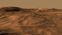
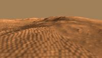
Late last week I stumbled upon a few HiRISE derived DEM's (Randy Kirk works his magic once again!)
http://webgis.wr.usgs.gov/ftphirise/index.jsp (URL now down) I'm working on both Vic Crater and the Columbia Hills. Fortunately, now I've got a Mac, I can use ISIS. I've figured out a fairly simple flow ( isis2raw as 16 bit unsigned, and then imported into Photoshop ) to take DEM CUB's and make 16 bit PNG's  Just to demo how important that is for me as an animator - sliced comparisons of 8bit vs 16 bit. A busy week unfortunately, but animations of various sorts are in the pipeline.
Attached thumbnail(s)
|
||
 |
 
|
||
 |
|
Aug 22 2013, 06:45 PM
Post
#122
|
||
 Newbie Group: Members Posts: 12 Joined: 17-July 13 From: Earth Member No.: 6973 |
These are all great visualizations of the HiRISE elevation data, Doug your flyovers are simply superior. I am still crashing my spacecraft through the surface or veering off into the vast whiteness of space. I also think your layover here is outta this world, literally.
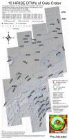
I wanted to visualize how the Gale Crater (msl study site) surface projects itself in terms of different sensors, as well as between the 10 adjacent HiRISE dtms listed on the map. A two-framed flashing movie here is an example of feature dislocation at the edge of the orthographic images. The map below projects those differences at 50-meter breaks spanning the 10 HiRISE dtm extent. The difference at the edges (featured in red) is most apparent in the Northern portion of the image. The hilly terrain to the south values are offset slightly compared to the Northern portion, but still visibly offset by some tens of meters in places. This offset affects the mosaic, and every model I run afterward, which is in conflict with my longing for order, especially in the overlapping regions of the map at larger extents. I have a couple ideas I may try but my mars time is slipping away rapidly to studies of a more earthly nature.... If anyone has experience geo-referencing or creating orthos I would greatly appreciate your comments.
|
|
|
|
|
|
 djellison HiRISE DEM's Apr 13 2008, 10:46 AM
 Mars3D Hi JRA,
I have 4GB of ram (only 3GB is usable bec... Nov 25 2010, 07:36 PM
Mars3D Hi JRA,
I have 4GB of ram (only 3GB is usable bec... Nov 25 2010, 07:36 PM
 JRA Hey, thanks for the reply and information. I think... Nov 26 2010, 06:25 AM djellison Any HiRISE DTM (and I assume HRSC DTM ) gets match... Aug 22 2013, 07:19 PM RoverDriver RRussman, each DTM is ortho rectified an as such t... Aug 22 2013, 07:48 PM Phil Stooke One lesson to take from this is that DEMs and asso... Aug 22 2013, 07:48 PM RRussman Doug, Im pretty sure everything is matched to MOL... Aug 24 2013, 11:35 PM
 |

|
Lo-Fi Version | Time is now: 5th June 2024 - 04:58 AM |
|
RULES AND GUIDELINES Please read the Forum Rules and Guidelines before posting. IMAGE COPYRIGHT |
OPINIONS AND MODERATION Opinions expressed on UnmannedSpaceflight.com are those of the individual posters and do not necessarily reflect the opinions of UnmannedSpaceflight.com or The Planetary Society. The all-volunteer UnmannedSpaceflight.com moderation team is wholly independent of The Planetary Society. The Planetary Society has no influence over decisions made by the UnmannedSpaceflight.com moderators. |
SUPPORT THE FORUM Unmannedspaceflight.com is funded by the Planetary Society. Please consider supporting our work and many other projects by donating to the Society or becoming a member. |
|