Water plumes over Europa |

Water plumes over Europa |
 Dec 12 2013, 04:55 PM Dec 12 2013, 04:55 PM
Post
#1
|
|
|
Member  Group: Members Posts: 401 Joined: 5-January 07 From: Manchester England Member No.: 1563 |
This seems like the relevant place to post this (could be wrong): Water plumes from Europa? Apologies if it's already been up. The link to the Science article at the bottom doesn't work for me, does anyone have a working link to the original? Cheers.
-------------------- |
 |
 
|
 |
|
Dec 12 2013, 10:02 PM
Post
#2
|
||
 IMG to PNG GOD Group: Moderator Posts: 2254 Joined: 19-February 04 From: Near fire and ice Member No.: 38 |
I have now taken a quick look at the article. An enhanced emission was detected near 90° west longitude. Here is a quick and dirty orthographic render of Europa's southern hemisphere:
If I understand the article correctly the most likely location for the plume source is near longitude 90°W in the far south. As the render above shows, most of the terrain in the area of interest isn't very well imaged although there is a narrow swath of good images near 90°W. There are some Europa diagrams near the top in this interesting blog entry at the Planetary Society website but the diagrams are rather fuzzy and it's not completely obvious to me what they are showing or where - possibly the location of a likely source region. It will be interesting to see how this affects the JUICE plans. Plumes like this one should be easily detectable by JUICE - the problem is if they are transient. As currently planned, the closest approach occurs approximately over Thrace and Thera Macula (in the image above, the two dark spots near bottom at 180°W). |
|
|
|
|
|
|
Dec 13 2013, 04:19 PM
Post
#3
|
|||
 Administrator Group: Admin Posts: 5172 Joined: 4-August 05 From: Pasadena, CA, USA, Earth Member No.: 454 |
QUOTE (Bjorn Jonsson @ Dec 12 2013, 02:02 PM)  I have now taken a quick look at the article. An enhanced emission was detected near 90° west longitude. Here is a quick and dirty orthographic render of Europa's southern hemisphere:
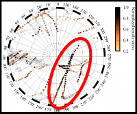
If I understand the article correctly the most likely location for the plume source is near longitude 90°W in the far south. As the render above shows, most of the terrain in the area of interest isn't very well imaged although there is a narrow swath of good images near 90°W. There are some Europa diagrams near the top in this interesting blog entry at the Planetary Society website but the diagrams are rather fuzzy and it's not completely obvious to me ... Thanks for making that orthographic image. Here is a higher-resolution version of the graphic that I put in that blog entry. It shows a model for stresses along cracks near the south pole when Europa is at apoapsis. Can you identify which specific images contain these cracks?
-------------------- My website - My Patreon - @elakdawalla on Twitter - Please support unmannedspaceflight.com by donating here.
|
||
|
|
|
||
|
Dec 13 2013, 08:44 PM
Post
#4
|
|||
|
IMG to PNG GOD Group: Moderator Posts: 2254 Joined: 19-February 04 From: Near fire and ice Member No.: 38 |
QUOTE (elakdawalla @ Dec 13 2013, 04:19 PM) Thanks for making that orthographic image. Here is a higher-resolution version of the graphic that I put in that blog entry. It shows a model for stresses along cracks near the south pole when Europa is at apoapsis. Can you identify which specific images contain these cracks?
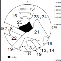
Not unexpectedly, the imaging coverage is somewhat limited. There is a very big map available from the USGS together with an image footprint chart (europa_simp.pdf): http://astrogeology.usgs.gov/search/detail...obal-Mosaic/cub I can't find an image footprint chart for the south polar region at the USGS website now but here is the relevant part from one I downloaded back in 2001 so there might be changes (not big though). The numbers are the same as in europa_simp.pdf. The longitudes were added by me:
The northernmost latitude is probably ~55°S (I can't find an exact number anywhere). Much of the terrain in the red ellipse has been imaged at 1.5-2 km/pixel resolution. The main/only exception is what's labeled as 13 in europa_simp.pdf mentioned above. These are images from orbit 17, observation id 17ESREGMAP01. These images have a resolution of ~200 m/pixel. More interestingly, observation 17ESSTRSLP01 has images of Astypalaea Linea which is within the red ellipse and has high tensile stress. They have a resolution of ~40 m/pixel and these images are not in the USGS map (their resolution really is too high for a 500 m/pixel map). Photojournal images: http://photojournal.jpl.nasa.gov/catalog/PIA02960 http://photojournal.jpl.nasa.gov/catalog/PIA01645 Interestingly, the terrain in the red ellipse is not in view when the plume was visible - at that time the sub-observer longitude was ~90. If the activity is within the red ellipse it means the plume is seen poking above the limb from behind. I don't know if it's of significance or not but Thrace and Thera Macula aren't very far from the red ellipse. If I have understood everything correctly, as currently planned they are a major focus of interest for JUICE near closest approach during its two close Europa flybys. These two maculae have been considered to be among the most likely places on Europa to be currently active (chaos formation in progress) although I don't remember the exact details. |
||
|
|
|
||
|
Dec 15 2013, 07:25 PM
Post
#5
|
|
 Senior Member Group: Members Posts: 2530 Joined: 20-April 05 Member No.: 321 |
One of the tricky factors in our limited Europa coverage is the enormous importance of sun angle. The surface is very rough and low sun angle creates shadows along linear features which appear dark. This is easy to confuse with the albedo differences that pertain to composition (dark -> higher non-H2O constituents).
One of the hypotheses for the darker (low albedo, not shadow) linear features is that emission of subsurface liquids which are "dirty" deposit along open fissures, spraying the dark material to the sides. If this is correct, then the active plumes may exist exactly where linear features with low albedo are most prominent. There are so many unknowns in the above, I couldn't begin to estimate how likely this is to be true, but at least if one is beginning to consider possibilities, that seems like the possibility to start with. We're not going to get better maps of Europa until a spacecraft sends them back. Theoretical work on the location of stresses is a nice start, but they depend on unknown and (given only the data we have) unknowable parameters concerning the structure of the icy shell. I don't see any way to pin down the origin of the plumes until observations can be made in situ. That's assuming, in fact, that the plumes and their sources are even persistent over a period of years. Maybe 2023's plumes (if any) will be different than the ones observed so far. |
|
|
|
 marsbug Water plumes over Europa Dec 12 2013, 04:55 PM
 Hungry4info Here's a link to the paper.
http://hubblesite.... Dec 12 2013, 05:08 PM JRehling Apparently, Europa joins Enceladus in having activ... Dec 12 2013, 07:20 PM marsbug QUOTE (Hungry4info @ Dec 12 2013, 05:08 P... Dec 12 2013, 08:32 PM
Hungry4info Here's a link to the paper.
http://hubblesite.... Dec 12 2013, 05:08 PM JRehling Apparently, Europa joins Enceladus in having activ... Dec 12 2013, 07:20 PM marsbug QUOTE (Hungry4info @ Dec 12 2013, 05:08 P... Dec 12 2013, 08:32 PM
 JRehling The modeled density is comparable to that of plume... Dec 12 2013, 09:27 PM rlorenz QUOTE (JRehling @ Dec 12 2013, 04:27 PM) ... Dec 12 2013, 11:38 PM Juramike QUOTE (rlorenz @ Dec 12 2013, 07:38 PM) S... Dec 13 2013, 03:31 AM JRehling There's certainly some evidence of carbon in/o... Dec 13 2013, 06:09 PM JRehling Coincidentally, I'd already asked for the very... Dec 30 2013, 07:10 PM rlorenz QUOTE (JRehling @ Dec 30 2013, 02:10 PM) ... Dec 31 2013, 05:47 PM nprev I think this finding dramatically strengthens the ... Dec 12 2013, 10:14 PM 0101Morpheus I think only Europa is the only moon with a thin e... Dec 12 2013, 10:31 PM elakdawalla Wouldn't infalling comets deliver carbon to Eu... Dec 12 2013, 11:39 PM rlorenz QUOTE (elakdawalla @ Dec 12 2013, 06:39 P... Dec 14 2013, 04:32 PM marsbug QUOTE (rlorenz @ Dec 14 2013, 04:32 PM) O... Dec 15 2013, 04:12 PM nprev I wonder about that. Certainly the Jovian system g... Dec 13 2013, 01:19 AM marsbug A habitable environment without life would be very... Dec 13 2013, 12:03 PM vjkane Looking at smaller missions than ESA's JUICE o... Dec 13 2013, 03:36 PM nprev Thing is, it seems as if the plumes are rapidly ch... Dec 13 2013, 07:29 PM JRehling The duration of exposure to local radiation would ... Dec 13 2013, 07:54 PM MarcF Emily, do you mean that Astypalaea and Thasus Line... Dec 13 2013, 07:46 PM elakdawalla I wrote an article two years ago about Britney Sch... Dec 13 2013, 10:01 PM Bjorn Jonsson Here is a quick (i.e. seams might be visible somew... Dec 14 2013, 01:18 AM elakdawalla The cross-cutting relationships through here are j... Dec 14 2013, 01:35 AM Bjorn Jonsson Yes, this is interesting terrain. In hindsight it ... Dec 14 2013, 01:48 AM vexgizmo The area of interest is along 180 lon; the authors... Dec 15 2013, 03:26 PM vexgizmo And from the USGS global map (colorized).
Dec 15 2013, 03:30 PM scalbers In these blog comments in a Planetary Society post... Dec 15 2013, 08:10 PM ngunn I see only two references to Galileo in that artic... Dec 15 2013, 09:02 PM scalbers True any plumes aren't mentioned in the blog a... Dec 15 2013, 09:05 PM Bjorn Jonsson I think plumes are extremely unlikely to be presen... Dec 15 2013, 10:00 PM machi I looked at Galileo images of Europa and I found o... Dec 16 2013, 01:37 AM tedstryk Fieseler is the one who was behind the star tracke... Dec 16 2013, 01:40 AM JRehling I notice that the putative haze in the haze image ... Dec 16 2013, 05:47 PM machi Yes, I think that's the most plausible explana... Dec 16 2013, 01:47 AM Bjorn Jonsson I agree, looking closely this looks like a double ... Dec 16 2013, 08:37 PM ngunn QUOTE (Bjorn Jonsson @ Dec 16 2013, 08:37... Dec 16 2013, 09:24 PM vexgizmo QUOTE (ngunn @ Dec 16 2013, 03:24 PM) I a... Dec 18 2013, 02:02 PM nprev I kinda said this earlier, but it it possible that... Dec 16 2013, 10:46 PM JRehling I'm curious as to what would be the half-life ... Dec 17 2013, 11:44 PM dvandorn I guess I'll be the one who asks -- how much m... Dec 31 2013, 06:00 PM rlorenz QUOTE (dvandorn @ Dec 31 2013, 01:00 PM) ... Jan 1 2014, 03:28 PM Gerald I'd think, that the carbon-nitrogen triple bon... Dec 31 2013, 10:59 PM dvandorn So, observed species abundances reflect the end re... Jan 1 2014, 05:12 PM JRehling Other Doug,
I think it's useful to consider th... Jan 3 2014, 06:57 PM JRehling The options for future Europa missions have to hig... Jan 8 2014, 10:21 PM Gerald Some species will escape, and therefore thin out s... Jan 1 2014, 06:23 PM Explorer1 The issue with parking directly in Europa orbit fo... Jan 8 2014, 11:54 PM JRehling A craft would have limited lifetime in Europa orbi... Jan 9 2014, 06:04 AM vjkane QUOTE (JRehling @ Jan 8 2014, 10:04 PM) A... Jan 9 2014, 05:44 PM JRehling For a mission that sits in a circular parking orbi... Jan 9 2014, 07:30 PM vjkane QUOTE (JRehling @ Jan 9 2014, 11:30 AM) F... Jan 9 2014, 10:46 PM vjkane If the plumes are shown to be consistent and persi... Jan 9 2014, 03:14 AM MarcF Any chance that the Gemini Planet Finder instrumen... Jan 9 2014, 07:55 PM ugordan I'm skeptical since GPI operates in infrared a... Jan 9 2014, 08:13 PM Bjorn Jonsson Before a sample return mission (possibly somewhat ... Jan 9 2014, 10:07 PM JRehling As mentioned earlier, opportunities when Europa oc... Jan 9 2014, 10:54 PM Paolo I am too lazy to go through the references, so I a... Jan 10 2014, 10:44 AM MarcF I am probably very naive, but I thought, if we can... Jan 10 2014, 01:09 PM ugordan QUOTE (MarcF @ Jan 10 2014, 02:09 PM) I a... Jan 10 2014, 02:01 PM Greenish According to this document among others, Gaia will... Jan 10 2014, 01:58 PM MarcF Thanks for the answer Ugordan. So we will have to ... Jan 10 2014, 02:43 PM vjkane We will know long before two decades whether or no... Jan 10 2014, 05:51 PM JRehling One note on the geometry of the plumes: They, like... Jan 10 2014, 06:24 PM vexgizmo Back in December, there was discussion of the avai... Feb 26 2014, 11:21 PM Phil Stooke I had a vague recollection that Voyager images of ... Feb 27 2014, 02:40 PM Ian R QUOTE (Phil Stooke @ Feb 27 2014, 02:40 P... Feb 27 2014, 04:09 PM Ian R QUOTE (Phil Stooke @ Feb 27 2014, 02:40 P... Feb 27 2014, 04:18 PM Phil Stooke Not so fast! I was summarizing. The version ... Feb 27 2014, 05:23 PM ollopa Bob Pappalardo and an assembled cast of the usual ... Feb 28 2014, 01:43 PM vexgizmo QUOTE (ollopa @ Feb 28 2014, 07:43 AM) Bo... Mar 8 2014, 04:29 PM Ian R I'm glad to hear that Phil. Makes me wonder ho... Feb 27 2014, 05:53 PM JohnVV QUOTE Makes me wonder how they managed to tease ou... Feb 28 2014, 02:53 AM tedstryk Tempting, but I've been trying to search a plu... Feb 28 2014, 11:40 AM TheAnt Despite the result from the Hubble telescope, a ch... Dec 22 2014, 06:03 PM Vultur QUOTE (TheAnt @ Dec 22 2014, 06:03 PM) De... Dec 23 2014, 04:21 AM tedstryk I've reviewed virtually every image from Galil... Dec 24 2014, 04:27 AM vjkane QUOTE (Vultur @ Dec 22 2014, 08:21 PM) Th... Dec 24 2014, 06:19 AM TheAnt QUOTE (Vultur @ Dec 23 2014, 05:21 AM) Th... Dec 25 2014, 06:46 AM rlorenz QUOTE (TheAnt @ Dec 25 2014, 01:46 AM) @V... Dec 25 2014, 04:24 PM TheAnt QUOTE (rlorenz @ Dec 25 2014, 05:24 PM) J... Dec 26 2014, 07:42 AM vjkane QUOTE (rlorenz @ Dec 25 2014, 08:24 AM) J... Dec 28 2014, 04:18 AM nprev I wouldn't characterize Enceladus' plumes ... Dec 24 2014, 01:07 PM Explorer1 If it was an impact that caused the plumes, would ... Dec 25 2014, 07:43 AM katodomo According to its Yellow Book (page 26), JUICE will... Dec 25 2014, 11:19 AM Bjorn Jonsson QUOTE (Explorer1 @ Dec 25 2014, 07:43 AM)... Dec 25 2014, 11:28 PM nprev Might not have been a particularly large impactor;... Dec 25 2014, 04:09 PM nprev Nobody's keeping score, man.
If I could pick... Dec 28 2014, 05:24 AM TheAnt Not plumes, but another matter about Europa, signs... Dec 28 2014, 01:25 PM Fran Ontanaya No confirmation for plumes yet:
http://www.scient... Jan 2 2015, 09:17 AM Hungry4info NASA to Hold Media Call on Evidence of Surprising ... Sep 20 2016, 10:44 PM JRehling QUOTE (Hungry4info @ Sep 20 2016, 03:44 P... Sep 22 2016, 01:07 AM B Bernatchez Water plumes detected by Hubble: http://www.nasa.... Sep 26 2016, 06:44 PM Phil Stooke Hot from Twitter:
" Emily Lakdawalla Retweet... Sep 26 2016, 07:19 PM Brian Burns QUOTE (Phil Stooke @ Sep 26 2016, 02:19 P... Sep 26 2016, 10:56 PM JohnVV grabbed the image "c2076737.imq"
fa... Sep 26 2016, 11:29 PM
JRehling The modeled density is comparable to that of plume... Dec 12 2013, 09:27 PM rlorenz QUOTE (JRehling @ Dec 12 2013, 04:27 PM) ... Dec 12 2013, 11:38 PM Juramike QUOTE (rlorenz @ Dec 12 2013, 07:38 PM) S... Dec 13 2013, 03:31 AM JRehling There's certainly some evidence of carbon in/o... Dec 13 2013, 06:09 PM JRehling Coincidentally, I'd already asked for the very... Dec 30 2013, 07:10 PM rlorenz QUOTE (JRehling @ Dec 30 2013, 02:10 PM) ... Dec 31 2013, 05:47 PM nprev I think this finding dramatically strengthens the ... Dec 12 2013, 10:14 PM 0101Morpheus I think only Europa is the only moon with a thin e... Dec 12 2013, 10:31 PM elakdawalla Wouldn't infalling comets deliver carbon to Eu... Dec 12 2013, 11:39 PM rlorenz QUOTE (elakdawalla @ Dec 12 2013, 06:39 P... Dec 14 2013, 04:32 PM marsbug QUOTE (rlorenz @ Dec 14 2013, 04:32 PM) O... Dec 15 2013, 04:12 PM nprev I wonder about that. Certainly the Jovian system g... Dec 13 2013, 01:19 AM marsbug A habitable environment without life would be very... Dec 13 2013, 12:03 PM vjkane Looking at smaller missions than ESA's JUICE o... Dec 13 2013, 03:36 PM nprev Thing is, it seems as if the plumes are rapidly ch... Dec 13 2013, 07:29 PM JRehling The duration of exposure to local radiation would ... Dec 13 2013, 07:54 PM MarcF Emily, do you mean that Astypalaea and Thasus Line... Dec 13 2013, 07:46 PM elakdawalla I wrote an article two years ago about Britney Sch... Dec 13 2013, 10:01 PM Bjorn Jonsson Here is a quick (i.e. seams might be visible somew... Dec 14 2013, 01:18 AM elakdawalla The cross-cutting relationships through here are j... Dec 14 2013, 01:35 AM Bjorn Jonsson Yes, this is interesting terrain. In hindsight it ... Dec 14 2013, 01:48 AM vexgizmo The area of interest is along 180 lon; the authors... Dec 15 2013, 03:26 PM vexgizmo And from the USGS global map (colorized).
Dec 15 2013, 03:30 PM scalbers In these blog comments in a Planetary Society post... Dec 15 2013, 08:10 PM ngunn I see only two references to Galileo in that artic... Dec 15 2013, 09:02 PM scalbers True any plumes aren't mentioned in the blog a... Dec 15 2013, 09:05 PM Bjorn Jonsson I think plumes are extremely unlikely to be presen... Dec 15 2013, 10:00 PM machi I looked at Galileo images of Europa and I found o... Dec 16 2013, 01:37 AM tedstryk Fieseler is the one who was behind the star tracke... Dec 16 2013, 01:40 AM JRehling I notice that the putative haze in the haze image ... Dec 16 2013, 05:47 PM machi Yes, I think that's the most plausible explana... Dec 16 2013, 01:47 AM Bjorn Jonsson I agree, looking closely this looks like a double ... Dec 16 2013, 08:37 PM ngunn QUOTE (Bjorn Jonsson @ Dec 16 2013, 08:37... Dec 16 2013, 09:24 PM vexgizmo QUOTE (ngunn @ Dec 16 2013, 03:24 PM) I a... Dec 18 2013, 02:02 PM nprev I kinda said this earlier, but it it possible that... Dec 16 2013, 10:46 PM JRehling I'm curious as to what would be the half-life ... Dec 17 2013, 11:44 PM dvandorn I guess I'll be the one who asks -- how much m... Dec 31 2013, 06:00 PM rlorenz QUOTE (dvandorn @ Dec 31 2013, 01:00 PM) ... Jan 1 2014, 03:28 PM Gerald I'd think, that the carbon-nitrogen triple bon... Dec 31 2013, 10:59 PM dvandorn So, observed species abundances reflect the end re... Jan 1 2014, 05:12 PM JRehling Other Doug,
I think it's useful to consider th... Jan 3 2014, 06:57 PM JRehling The options for future Europa missions have to hig... Jan 8 2014, 10:21 PM Gerald Some species will escape, and therefore thin out s... Jan 1 2014, 06:23 PM Explorer1 The issue with parking directly in Europa orbit fo... Jan 8 2014, 11:54 PM JRehling A craft would have limited lifetime in Europa orbi... Jan 9 2014, 06:04 AM vjkane QUOTE (JRehling @ Jan 8 2014, 10:04 PM) A... Jan 9 2014, 05:44 PM JRehling For a mission that sits in a circular parking orbi... Jan 9 2014, 07:30 PM vjkane QUOTE (JRehling @ Jan 9 2014, 11:30 AM) F... Jan 9 2014, 10:46 PM vjkane If the plumes are shown to be consistent and persi... Jan 9 2014, 03:14 AM MarcF Any chance that the Gemini Planet Finder instrumen... Jan 9 2014, 07:55 PM ugordan I'm skeptical since GPI operates in infrared a... Jan 9 2014, 08:13 PM Bjorn Jonsson Before a sample return mission (possibly somewhat ... Jan 9 2014, 10:07 PM JRehling As mentioned earlier, opportunities when Europa oc... Jan 9 2014, 10:54 PM Paolo I am too lazy to go through the references, so I a... Jan 10 2014, 10:44 AM MarcF I am probably very naive, but I thought, if we can... Jan 10 2014, 01:09 PM ugordan QUOTE (MarcF @ Jan 10 2014, 02:09 PM) I a... Jan 10 2014, 02:01 PM Greenish According to this document among others, Gaia will... Jan 10 2014, 01:58 PM MarcF Thanks for the answer Ugordan. So we will have to ... Jan 10 2014, 02:43 PM vjkane We will know long before two decades whether or no... Jan 10 2014, 05:51 PM JRehling One note on the geometry of the plumes: They, like... Jan 10 2014, 06:24 PM vexgizmo Back in December, there was discussion of the avai... Feb 26 2014, 11:21 PM Phil Stooke I had a vague recollection that Voyager images of ... Feb 27 2014, 02:40 PM Ian R QUOTE (Phil Stooke @ Feb 27 2014, 02:40 P... Feb 27 2014, 04:09 PM Ian R QUOTE (Phil Stooke @ Feb 27 2014, 02:40 P... Feb 27 2014, 04:18 PM Phil Stooke Not so fast! I was summarizing. The version ... Feb 27 2014, 05:23 PM ollopa Bob Pappalardo and an assembled cast of the usual ... Feb 28 2014, 01:43 PM vexgizmo QUOTE (ollopa @ Feb 28 2014, 07:43 AM) Bo... Mar 8 2014, 04:29 PM Ian R I'm glad to hear that Phil. Makes me wonder ho... Feb 27 2014, 05:53 PM JohnVV QUOTE Makes me wonder how they managed to tease ou... Feb 28 2014, 02:53 AM tedstryk Tempting, but I've been trying to search a plu... Feb 28 2014, 11:40 AM TheAnt Despite the result from the Hubble telescope, a ch... Dec 22 2014, 06:03 PM Vultur QUOTE (TheAnt @ Dec 22 2014, 06:03 PM) De... Dec 23 2014, 04:21 AM tedstryk I've reviewed virtually every image from Galil... Dec 24 2014, 04:27 AM vjkane QUOTE (Vultur @ Dec 22 2014, 08:21 PM) Th... Dec 24 2014, 06:19 AM TheAnt QUOTE (Vultur @ Dec 23 2014, 05:21 AM) Th... Dec 25 2014, 06:46 AM rlorenz QUOTE (TheAnt @ Dec 25 2014, 01:46 AM) @V... Dec 25 2014, 04:24 PM TheAnt QUOTE (rlorenz @ Dec 25 2014, 05:24 PM) J... Dec 26 2014, 07:42 AM vjkane QUOTE (rlorenz @ Dec 25 2014, 08:24 AM) J... Dec 28 2014, 04:18 AM nprev I wouldn't characterize Enceladus' plumes ... Dec 24 2014, 01:07 PM Explorer1 If it was an impact that caused the plumes, would ... Dec 25 2014, 07:43 AM katodomo According to its Yellow Book (page 26), JUICE will... Dec 25 2014, 11:19 AM Bjorn Jonsson QUOTE (Explorer1 @ Dec 25 2014, 07:43 AM)... Dec 25 2014, 11:28 PM nprev Might not have been a particularly large impactor;... Dec 25 2014, 04:09 PM nprev Nobody's keeping score, man.
If I could pick... Dec 28 2014, 05:24 AM TheAnt Not plumes, but another matter about Europa, signs... Dec 28 2014, 01:25 PM Fran Ontanaya No confirmation for plumes yet:
http://www.scient... Jan 2 2015, 09:17 AM Hungry4info NASA to Hold Media Call on Evidence of Surprising ... Sep 20 2016, 10:44 PM JRehling QUOTE (Hungry4info @ Sep 20 2016, 03:44 P... Sep 22 2016, 01:07 AM B Bernatchez Water plumes detected by Hubble: http://www.nasa.... Sep 26 2016, 06:44 PM Phil Stooke Hot from Twitter:
" Emily Lakdawalla Retweet... Sep 26 2016, 07:19 PM Brian Burns QUOTE (Phil Stooke @ Sep 26 2016, 02:19 P... Sep 26 2016, 10:56 PM JohnVV grabbed the image "c2076737.imq"
fa... Sep 26 2016, 11:29 PM |

|
Lo-Fi Version | Time is now: 26th September 2024 - 09:08 PM |
|
RULES AND GUIDELINES Please read the Forum Rules and Guidelines before posting. IMAGE COPYRIGHT |
OPINIONS AND MODERATION Opinions expressed on UnmannedSpaceflight.com are those of the individual posters and do not necessarily reflect the opinions of UnmannedSpaceflight.com or The Planetary Society. The all-volunteer UnmannedSpaceflight.com moderation team is wholly independent of The Planetary Society. The Planetary Society has no influence over decisions made by the UnmannedSpaceflight.com moderators. |
SUPPORT THE FORUM Unmannedspaceflight.com is funded by the Planetary Society. Please consider supporting our work and many other projects by donating to the Society or becoming a member. |
|