Yutu Route Map |

Yutu Route Map |
 Dec 15 2013, 04:30 PM Dec 15 2013, 04:30 PM
Post
#1
|
||
|
Solar System Cartographer  Group: Members Posts: 10226 Joined: 5-April 05 From: Canada Member No.: 227 |
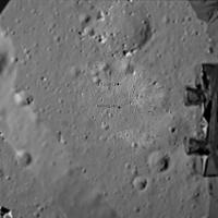
First route map! I will keep it going, mostly on LROC images, as I need it for a future project. I am still working on an accurate scale.
Phil
-------------------- ... because the Solar System ain't gonna map itself.
Also to be found posting similar content on https://mastodon.social/@PhilStooke Maps for download (free PDF: https://upload.wikimedia.org/wikipedia/comm...Cartography.pdf NOTE: everything created by me which I post on UMSF is considered to be in the public domain (NOT CC, public domain) |
|
 |
 
|
|
 |
|
Dec 24 2013, 09:24 PM
Post
#2
|
|
 Senior Member Group: Members Posts: 1729 Joined: 3-August 06 From: 43° 35' 53" N 1° 26' 35" E Member No.: 1004 |
this link (in Chinese) gives some details of the future objectives of Yutu's traverses:
http://news.xinhuanet.com/mil/2013-12/24/c_118692396.htm a "large stone pyramid" about 42 meters SW of the lander, the a high ground to the W and a crater 10 m to the N. the link also gives some detail of the driving sessions. |
|
|
|
 Phil Stooke Yutu Route Map Dec 15 2013, 04:30 PM
 elakdawalla Now that we have six wheels on soil we need a dedi... Dec 16 2013, 06:34 PM kenny Could we re-post the landing site location images ... Dec 16 2013, 10:30 PM
 Thorsten Denk Yes, we can.
Thorsten Dec 17 2013, 10:27 PM kenny Thanks, Thorsten and Phil,
I watched a lot of CNT... Dec 19 2013, 11:53 AM Phil Stooke You can find it here
Or by looking down this page... Dec 19 2013, 12:00 PM Betelgeuze Based on the new panorama, this is what I would su... Dec 20 2013, 08:18 PM Phil Stooke I agree... I was holding off until I knew which da... Dec 20 2013, 08:38 PM Phil Stooke My update of the map...
Phil
Dec 21 2013, 03:51 AM Phil Stooke I have modified the map to include the 21 December... Dec 21 2013, 11:11 PM Phil Stooke Update to 22 December - but the exact location is ... Dec 22 2013, 03:23 PM vikingmars QUOTE (Phil Stooke @ Dec 22 2013, 04:23 P... Dec 24 2013, 08:37 AM kenny Total distance travelled to date, according to Xin... Dec 23 2013, 03:22 PM Phil Stooke The pyramid will be the large rock in the corner o... Dec 24 2013, 10:06 PM Phil Stooke This is a very tentative map update. We have no i... Dec 28 2013, 09:52 PM vikingmars QUOTE (Phil Stooke @ Dec 28 2013, 10:52 P... Dec 30 2013, 11:36 PM djellison QUOTE (vikingmars @ Dec 30 2013, 03:36 PM... Dec 31 2013, 02:44 AM Phil Stooke Merci! Here's another update including a ... Dec 31 2013, 02:47 AM Explorer1 LRO can make up for the lack of reports quite easi... Dec 31 2013, 03:32 AM Phil Stooke I'm hoping for a few names!
Phil Dec 31 2013, 04:00 AM Phil Stooke Map update to 14 January - I don't know the da... Jan 15 2014, 12:12 AM Liss In a Chinese news report from Jan 14 current posit... Jan 19 2014, 08:32 PM Liss Similar data were found for points A (15 Dec 2013)... Jan 19 2014, 10:45 PM Phil Stooke Interesting! Here is my map with a 10 m grid ... Jan 19 2014, 11:42 PM Liss Phil, you are right and I was wrong!
What I r... Jan 20 2014, 01:13 AM Phil Stooke As you know there has been very little information... Feb 23 2014, 04:20 PM elakdawalla I'm sort of surprised we haven't seen any ... Feb 23 2014, 04:31 PM Phil Stooke Yes, we are overdue - some were expected during da... Feb 23 2014, 05:34 PM elakdawalla Since it took me a while to dig it up, I'll po... Feb 24 2014, 05:32 PM Phil Stooke I am updating my route map to show a new estimate ... Feb 26 2014, 02:14 AM elakdawalla While the apparent closeness of the lander in the ... Feb 26 2014, 03:22 AM fredk If the distance between the L and R cameras is kno... Feb 26 2014, 03:42 PM RoverDriver Not necessarily. The relative position of the two... Feb 26 2014, 04:08 PM fredk Yes, that's what I meant - if you knew the rel... Feb 26 2014, 04:19 PM djellison QUOTE (fredk @ Feb 26 2014, 08:19 AM) if ... Feb 26 2014, 05:20 PM fredk QUOTE (djellison @ Feb 26 2014, 05:20 PM)... Feb 26 2014, 06:46 PM RoverDriver QUOTE (fredk @ Feb 26 2014, 08:19 AM) ...... Feb 26 2014, 05:29 PM Phil Stooke Very quick update based on the new LROC images.
... Mar 4 2014, 08:00 PM ngunn That's very strange. I'm looking at the sa... Mar 4 2014, 10:42 PM Phil Stooke I overlaid the image on my map to get the location... Mar 4 2014, 11:12 PM Phil Stooke This is a new version of the route map, as complet... Mar 23 2014, 06:43 PM A.Nemo I have read a new magazine
科学... Apr 14 2014, 07:28 AM Phil Stooke This is the same map shown on a poster at LPSC in ... Apr 14 2014, 11:09 AM Liss Numbers of positions appear to be straightforward:... Apr 14 2014, 06:31 PM Phil Stooke I have updated this map to include the newly named... Jun 11 2014, 11:03 PM Phil Stooke I have just been to a meeting with Long Xiao in wh... Sep 24 2014, 11:39 PM Paolo been reading a few papers presented at this year... Oct 21 2014, 07:00 PM Phil Stooke This is a version of my route map (route still nee... Nov 24 2014, 07:03 PM charborob "Celestial Cereals"? That's what I e... Nov 24 2014, 07:56 PM kenny What wonderful, poetic names!
And of course ex... Nov 24 2014, 09:40 PM Phil Stooke Here's a guide to the new names.
Phil
Nov 24 2014, 09:50 PM Phil Stooke This map adds the names and updates the route to t... Nov 25 2014, 12:15 AM vikingmars QUOTE (Phil Stooke @ Nov 25 2014, 01:15 A... Nov 25 2014, 05:17 PM Phil Stooke I am revising and extending my old Moon book, and ... Jan 12 2016, 06:41 PM
Thorsten Denk Yes, we can.
Thorsten Dec 17 2013, 10:27 PM kenny Thanks, Thorsten and Phil,
I watched a lot of CNT... Dec 19 2013, 11:53 AM Phil Stooke You can find it here
Or by looking down this page... Dec 19 2013, 12:00 PM Betelgeuze Based on the new panorama, this is what I would su... Dec 20 2013, 08:18 PM Phil Stooke I agree... I was holding off until I knew which da... Dec 20 2013, 08:38 PM Phil Stooke My update of the map...
Phil
Dec 21 2013, 03:51 AM Phil Stooke I have modified the map to include the 21 December... Dec 21 2013, 11:11 PM Phil Stooke Update to 22 December - but the exact location is ... Dec 22 2013, 03:23 PM vikingmars QUOTE (Phil Stooke @ Dec 22 2013, 04:23 P... Dec 24 2013, 08:37 AM kenny Total distance travelled to date, according to Xin... Dec 23 2013, 03:22 PM Phil Stooke The pyramid will be the large rock in the corner o... Dec 24 2013, 10:06 PM Phil Stooke This is a very tentative map update. We have no i... Dec 28 2013, 09:52 PM vikingmars QUOTE (Phil Stooke @ Dec 28 2013, 10:52 P... Dec 30 2013, 11:36 PM djellison QUOTE (vikingmars @ Dec 30 2013, 03:36 PM... Dec 31 2013, 02:44 AM Phil Stooke Merci! Here's another update including a ... Dec 31 2013, 02:47 AM Explorer1 LRO can make up for the lack of reports quite easi... Dec 31 2013, 03:32 AM Phil Stooke I'm hoping for a few names!
Phil Dec 31 2013, 04:00 AM Phil Stooke Map update to 14 January - I don't know the da... Jan 15 2014, 12:12 AM Liss In a Chinese news report from Jan 14 current posit... Jan 19 2014, 08:32 PM Liss Similar data were found for points A (15 Dec 2013)... Jan 19 2014, 10:45 PM Phil Stooke Interesting! Here is my map with a 10 m grid ... Jan 19 2014, 11:42 PM Liss Phil, you are right and I was wrong!
What I r... Jan 20 2014, 01:13 AM Phil Stooke As you know there has been very little information... Feb 23 2014, 04:20 PM elakdawalla I'm sort of surprised we haven't seen any ... Feb 23 2014, 04:31 PM Phil Stooke Yes, we are overdue - some were expected during da... Feb 23 2014, 05:34 PM elakdawalla Since it took me a while to dig it up, I'll po... Feb 24 2014, 05:32 PM Phil Stooke I am updating my route map to show a new estimate ... Feb 26 2014, 02:14 AM elakdawalla While the apparent closeness of the lander in the ... Feb 26 2014, 03:22 AM fredk If the distance between the L and R cameras is kno... Feb 26 2014, 03:42 PM RoverDriver Not necessarily. The relative position of the two... Feb 26 2014, 04:08 PM fredk Yes, that's what I meant - if you knew the rel... Feb 26 2014, 04:19 PM djellison QUOTE (fredk @ Feb 26 2014, 08:19 AM) if ... Feb 26 2014, 05:20 PM fredk QUOTE (djellison @ Feb 26 2014, 05:20 PM)... Feb 26 2014, 06:46 PM RoverDriver QUOTE (fredk @ Feb 26 2014, 08:19 AM) ...... Feb 26 2014, 05:29 PM Phil Stooke Very quick update based on the new LROC images.
... Mar 4 2014, 08:00 PM ngunn That's very strange. I'm looking at the sa... Mar 4 2014, 10:42 PM Phil Stooke I overlaid the image on my map to get the location... Mar 4 2014, 11:12 PM Phil Stooke This is a new version of the route map, as complet... Mar 23 2014, 06:43 PM A.Nemo I have read a new magazine
科学... Apr 14 2014, 07:28 AM Phil Stooke This is the same map shown on a poster at LPSC in ... Apr 14 2014, 11:09 AM Liss Numbers of positions appear to be straightforward:... Apr 14 2014, 06:31 PM Phil Stooke I have updated this map to include the newly named... Jun 11 2014, 11:03 PM Phil Stooke I have just been to a meeting with Long Xiao in wh... Sep 24 2014, 11:39 PM Paolo been reading a few papers presented at this year... Oct 21 2014, 07:00 PM Phil Stooke This is a version of my route map (route still nee... Nov 24 2014, 07:03 PM charborob "Celestial Cereals"? That's what I e... Nov 24 2014, 07:56 PM kenny What wonderful, poetic names!
And of course ex... Nov 24 2014, 09:40 PM Phil Stooke Here's a guide to the new names.
Phil
Nov 24 2014, 09:50 PM Phil Stooke This map adds the names and updates the route to t... Nov 25 2014, 12:15 AM vikingmars QUOTE (Phil Stooke @ Nov 25 2014, 01:15 A... Nov 25 2014, 05:17 PM Phil Stooke I am revising and extending my old Moon book, and ... Jan 12 2016, 06:41 PM |

|
Lo-Fi Version | Time is now: 22nd September 2024 - 03:50 AM |
|
RULES AND GUIDELINES Please read the Forum Rules and Guidelines before posting. IMAGE COPYRIGHT |
OPINIONS AND MODERATION Opinions expressed on UnmannedSpaceflight.com are those of the individual posters and do not necessarily reflect the opinions of UnmannedSpaceflight.com or The Planetary Society. The all-volunteer UnmannedSpaceflight.com moderation team is wholly independent of The Planetary Society. The Planetary Society has no influence over decisions made by the UnmannedSpaceflight.com moderators. |
SUPPORT THE FORUM Unmannedspaceflight.com is funded by the Planetary Society. Please consider supporting our work and many other projects by donating to the Society or becoming a member. |
|