Yutu Route Map |

Yutu Route Map |
 Dec 15 2013, 04:30 PM Dec 15 2013, 04:30 PM
Post
#1
|
||
|
Solar System Cartographer  Group: Members Posts: 10184 Joined: 5-April 05 From: Canada Member No.: 227 |
First route map! I will keep it going, mostly on LROC images, as I need it for a future project. I am still working on an accurate scale.
Phil
-------------------- ... because the Solar System ain't gonna map itself.
Also to be found posting similar content on https://mastodon.social/@PhilStooke Maps for download (free PD: https://upload.wikimedia.org/wikipedia/comm...Cartography.pdf NOTE: everything created by me which I post on UMSF is considered to be in the public domain (NOT CC, public domain) |
|
 |
 
|
|
 |
|
Jan 19 2014, 08:32 PM
Post
#2
|
||
|
Junior Member Group: Members Posts: 45 Joined: 18-July 05 Member No.: 439 |
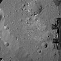
In a Chinese news report from Jan 14 current position was pictured as -32.61 meters (south) and -24.63 meters (west). Can't say what frame is in use -- either from lander or from the X point at the end of rails. The third number (27.17) relates to Yutu's attitude. The one to the right (129.23) is the Sun azimuth. There's also the fifth number outside of this frame -- Sun elevation (34.42 or so). Hope this helps to check/correct Phil's map.
Attached thumbnail(s)
|
|
|
|
|
|
 Phil Stooke Yutu Route Map Dec 15 2013, 04:30 PM
 Phil Stooke This is a very tentative map update. We have no i... Dec 28 2013, 09:52 PM
 vikingmars QUOTE (Phil Stooke @ Dec 28 2013, 10:52 P... Dec 30 2013, 11:36 PM djellison QUOTE (vikingmars @ Dec 30 2013, 03:36 PM... Dec 31 2013, 02:44 AM Phil Stooke Merci! Here's another update including a ... Dec 31 2013, 02:47 AM Explorer1 LRO can make up for the lack of reports quite easi... Dec 31 2013, 03:32 AM Phil Stooke I'm hoping for a few names!
Phil Dec 31 2013, 04:00 AM Phil Stooke Map update to 14 January - I don't know the da... Jan 15 2014, 12:12 AM Liss Similar data were found for points A (15 Dec 2013)... Jan 19 2014, 10:45 PM Phil Stooke Interesting! Here is my map with a 10 m grid ... Jan 19 2014, 11:42 PM Liss Phil, you are right and I was wrong!
What I r... Jan 20 2014, 01:13 AM Phil Stooke As you know there has been very little information... Feb 23 2014, 04:20 PM elakdawalla I'm sort of surprised we haven't seen any ... Feb 23 2014, 04:31 PM Phil Stooke Yes, we are overdue - some were expected during da... Feb 23 2014, 05:34 PM elakdawalla Since it took me a while to dig it up, I'll po... Feb 24 2014, 05:32 PM Phil Stooke I am updating my route map to show a new estimate ... Feb 26 2014, 02:14 AM elakdawalla While the apparent closeness of the lander in the ... Feb 26 2014, 03:22 AM fredk If the distance between the L and R cameras is kno... Feb 26 2014, 03:42 PM RoverDriver Not necessarily. The relative position of the two... Feb 26 2014, 04:08 PM fredk Yes, that's what I meant - if you knew the rel... Feb 26 2014, 04:19 PM djellison QUOTE (fredk @ Feb 26 2014, 08:19 AM) if ... Feb 26 2014, 05:20 PM fredk QUOTE (djellison @ Feb 26 2014, 05:20 PM)... Feb 26 2014, 06:46 PM RoverDriver QUOTE (fredk @ Feb 26 2014, 08:19 AM) ...... Feb 26 2014, 05:29 PM Phil Stooke Very quick update based on the new LROC images.
... Mar 4 2014, 08:00 PM ngunn That's very strange. I'm looking at the sa... Mar 4 2014, 10:42 PM Phil Stooke I overlaid the image on my map to get the location... Mar 4 2014, 11:12 PM Phil Stooke This is a new version of the route map, as complet... Mar 23 2014, 06:43 PM A.Nemo I have read a new magazine
科学... Apr 14 2014, 07:28 AM Phil Stooke This is the same map shown on a poster at LPSC in ... Apr 14 2014, 11:09 AM Liss Numbers of positions appear to be straightforward:... Apr 14 2014, 06:31 PM Phil Stooke I have updated this map to include the newly named... Jun 11 2014, 11:03 PM Phil Stooke I have just been to a meeting with Long Xiao in wh... Sep 24 2014, 11:39 PM Paolo been reading a few papers presented at this year... Oct 21 2014, 07:00 PM Phil Stooke This is a version of my route map (route still nee... Nov 24 2014, 07:03 PM charborob "Celestial Cereals"? That's what I e... Nov 24 2014, 07:56 PM kenny What wonderful, poetic names!
And of course ex... Nov 24 2014, 09:40 PM Phil Stooke Here's a guide to the new names.
Phil
Nov 24 2014, 09:50 PM Phil Stooke This map adds the names and updates the route to t... Nov 25 2014, 12:15 AM vikingmars QUOTE (Phil Stooke @ Nov 25 2014, 01:15 A... Nov 25 2014, 05:17 PM Phil Stooke I am revising and extending my old Moon book, and ... Jan 12 2016, 06:41 PM
vikingmars QUOTE (Phil Stooke @ Dec 28 2013, 10:52 P... Dec 30 2013, 11:36 PM djellison QUOTE (vikingmars @ Dec 30 2013, 03:36 PM... Dec 31 2013, 02:44 AM Phil Stooke Merci! Here's another update including a ... Dec 31 2013, 02:47 AM Explorer1 LRO can make up for the lack of reports quite easi... Dec 31 2013, 03:32 AM Phil Stooke I'm hoping for a few names!
Phil Dec 31 2013, 04:00 AM Phil Stooke Map update to 14 January - I don't know the da... Jan 15 2014, 12:12 AM Liss Similar data were found for points A (15 Dec 2013)... Jan 19 2014, 10:45 PM Phil Stooke Interesting! Here is my map with a 10 m grid ... Jan 19 2014, 11:42 PM Liss Phil, you are right and I was wrong!
What I r... Jan 20 2014, 01:13 AM Phil Stooke As you know there has been very little information... Feb 23 2014, 04:20 PM elakdawalla I'm sort of surprised we haven't seen any ... Feb 23 2014, 04:31 PM Phil Stooke Yes, we are overdue - some were expected during da... Feb 23 2014, 05:34 PM elakdawalla Since it took me a while to dig it up, I'll po... Feb 24 2014, 05:32 PM Phil Stooke I am updating my route map to show a new estimate ... Feb 26 2014, 02:14 AM elakdawalla While the apparent closeness of the lander in the ... Feb 26 2014, 03:22 AM fredk If the distance between the L and R cameras is kno... Feb 26 2014, 03:42 PM RoverDriver Not necessarily. The relative position of the two... Feb 26 2014, 04:08 PM fredk Yes, that's what I meant - if you knew the rel... Feb 26 2014, 04:19 PM djellison QUOTE (fredk @ Feb 26 2014, 08:19 AM) if ... Feb 26 2014, 05:20 PM fredk QUOTE (djellison @ Feb 26 2014, 05:20 PM)... Feb 26 2014, 06:46 PM RoverDriver QUOTE (fredk @ Feb 26 2014, 08:19 AM) ...... Feb 26 2014, 05:29 PM Phil Stooke Very quick update based on the new LROC images.
... Mar 4 2014, 08:00 PM ngunn That's very strange. I'm looking at the sa... Mar 4 2014, 10:42 PM Phil Stooke I overlaid the image on my map to get the location... Mar 4 2014, 11:12 PM Phil Stooke This is a new version of the route map, as complet... Mar 23 2014, 06:43 PM A.Nemo I have read a new magazine
科学... Apr 14 2014, 07:28 AM Phil Stooke This is the same map shown on a poster at LPSC in ... Apr 14 2014, 11:09 AM Liss Numbers of positions appear to be straightforward:... Apr 14 2014, 06:31 PM Phil Stooke I have updated this map to include the newly named... Jun 11 2014, 11:03 PM Phil Stooke I have just been to a meeting with Long Xiao in wh... Sep 24 2014, 11:39 PM Paolo been reading a few papers presented at this year... Oct 21 2014, 07:00 PM Phil Stooke This is a version of my route map (route still nee... Nov 24 2014, 07:03 PM charborob "Celestial Cereals"? That's what I e... Nov 24 2014, 07:56 PM kenny What wonderful, poetic names!
And of course ex... Nov 24 2014, 09:40 PM Phil Stooke Here's a guide to the new names.
Phil
Nov 24 2014, 09:50 PM Phil Stooke This map adds the names and updates the route to t... Nov 25 2014, 12:15 AM vikingmars QUOTE (Phil Stooke @ Nov 25 2014, 01:15 A... Nov 25 2014, 05:17 PM Phil Stooke I am revising and extending my old Moon book, and ... Jan 12 2016, 06:41 PM |

|
Lo-Fi Version | Time is now: 5th June 2024 - 12:16 AM |
|
RULES AND GUIDELINES Please read the Forum Rules and Guidelines before posting. IMAGE COPYRIGHT |
OPINIONS AND MODERATION Opinions expressed on UnmannedSpaceflight.com are those of the individual posters and do not necessarily reflect the opinions of UnmannedSpaceflight.com or The Planetary Society. The all-volunteer UnmannedSpaceflight.com moderation team is wholly independent of The Planetary Society. The Planetary Society has no influence over decisions made by the UnmannedSpaceflight.com moderators. |
SUPPORT THE FORUM Unmannedspaceflight.com is funded by the Planetary Society. Please consider supporting our work and many other projects by donating to the Society or becoming a member. |
|