Yutu Route Map |

Yutu Route Map |
 Dec 15 2013, 04:30 PM Dec 15 2013, 04:30 PM
Post
#1
|
||
|
Solar System Cartographer  Group: Members Posts: 10226 Joined: 5-April 05 From: Canada Member No.: 227 |
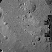
First route map! I will keep it going, mostly on LROC images, as I need it for a future project. I am still working on an accurate scale.
Phil
-------------------- ... because the Solar System ain't gonna map itself.
Also to be found posting similar content on https://mastodon.social/@PhilStooke Maps for download (free PDF: https://upload.wikimedia.org/wikipedia/comm...Cartography.pdf NOTE: everything created by me which I post on UMSF is considered to be in the public domain (NOT CC, public domain) |
|
 |
 
|
|
 |
|
Feb 26 2014, 04:19 PM
Post
#2
|
|
 Senior Member Group: Members Posts: 4256 Joined: 17-January 05 Member No.: 152 |
Yes, that's what I meant - if you knew the relative separation of the L and R rover cameras, then you can find the distance to the lander. I know information is sparse with this mission. But it may be possible to measure the L/R separation from a lander photo of the rover at known distance, or simply by comparing the L/R separation to the total width of the rover, if that's known reasonably well.
Knowing the L/R separation of the rover cameras (orthogonal to their optical axes), then it's a simple matter of trig to convert the measured parallax between the lander and the distant horizon (effectively at infinity) to the lander distance. (Maybe this is what you meant Paolo - without an absolute direction reference, we could not do this, since the L/R optical axes may not be parallel. But we do have such a reference, given by features on the distant horizon in the images.) |
|
|
|
|
Feb 26 2014, 05:20 PM
Post
#3
|
|
|
Founder Group: Chairman Posts: 14434 Joined: 8-February 04 Member No.: 1 |
QUOTE (fredk @ Feb 26 2014, 08:19 AM)  if you knew the relative separation of the L and R rover cameras AND the degree of toe in, if any. |
|
|
|
|
Feb 26 2014, 06:46 PM
Post
#4
|
|
|
Senior Member Group: Members Posts: 4256 Joined: 17-January 05 Member No.: 152 |
QUOTE (djellison @ Feb 26 2014, 05:20 PM) AND the degree of toe in, if any. That can be measured in pixels by looking at the shift in features on the distant horizon (effectively at infinity).The basic problem is that we need to know the pixel scale of the camera to convert pixels to an angle. Equivalently, as Paolo says, we need an object of known size and distance to give us a known angle. I'm used to MER/MSL, where we have that info easily available. But I'm guessing that's not the case with this mission. In principle, we could estimate the pixel scale since we have 360 degree pans. So if we can match distant features between the 360 and these new L/R images, we could estimate angles. Or, we could look at rover pancam images from the first lunar days and estimate the pixel scale from the (presumably) known size of the lander and distance from Phil's map. Then you have to assume/guess that those images are full frame rather than cropped. Either way, a lot of work. |
|
|
|
 Phil Stooke Yutu Route Map Dec 15 2013, 04:30 PM
 elakdawalla Now that we have six wheels on soil we need a dedi... Dec 16 2013, 06:34 PM kenny Could we re-post the landing site location images ... Dec 16 2013, 10:30 PM
 Thorsten Denk Yes, we can.
Thorsten Dec 17 2013, 10:27 PM kenny Thanks, Thorsten and Phil,
I watched a lot of CNT... Dec 19 2013, 11:53 AM Phil Stooke You can find it here
Or by looking down this page... Dec 19 2013, 12:00 PM Betelgeuze Based on the new panorama, this is what I would su... Dec 20 2013, 08:18 PM Phil Stooke I agree... I was holding off until I knew which da... Dec 20 2013, 08:38 PM Phil Stooke My update of the map...
Phil
Dec 21 2013, 03:51 AM Phil Stooke I have modified the map to include the 21 December... Dec 21 2013, 11:11 PM Phil Stooke Update to 22 December - but the exact location is ... Dec 22 2013, 03:23 PM vikingmars QUOTE (Phil Stooke @ Dec 22 2013, 04:23 P... Dec 24 2013, 08:37 AM kenny Total distance travelled to date, according to Xin... Dec 23 2013, 03:22 PM Paolo this link (in Chinese) gives some details of the f... Dec 24 2013, 09:24 PM Phil Stooke The pyramid will be the large rock in the corner o... Dec 24 2013, 10:06 PM Phil Stooke This is a very tentative map update. We have no i... Dec 28 2013, 09:52 PM vikingmars QUOTE (Phil Stooke @ Dec 28 2013, 10:52 P... Dec 30 2013, 11:36 PM djellison QUOTE (vikingmars @ Dec 30 2013, 03:36 PM... Dec 31 2013, 02:44 AM Phil Stooke Merci! Here's another update including a ... Dec 31 2013, 02:47 AM Explorer1 LRO can make up for the lack of reports quite easi... Dec 31 2013, 03:32 AM Phil Stooke I'm hoping for a few names!
Phil Dec 31 2013, 04:00 AM Phil Stooke Map update to 14 January - I don't know the da... Jan 15 2014, 12:12 AM Liss In a Chinese news report from Jan 14 current posit... Jan 19 2014, 08:32 PM Liss Similar data were found for points A (15 Dec 2013)... Jan 19 2014, 10:45 PM Phil Stooke Interesting! Here is my map with a 10 m grid ... Jan 19 2014, 11:42 PM Liss Phil, you are right and I was wrong!
What I r... Jan 20 2014, 01:13 AM Phil Stooke As you know there has been very little information... Feb 23 2014, 04:20 PM elakdawalla I'm sort of surprised we haven't seen any ... Feb 23 2014, 04:31 PM Phil Stooke Yes, we are overdue - some were expected during da... Feb 23 2014, 05:34 PM elakdawalla Since it took me a while to dig it up, I'll po... Feb 24 2014, 05:32 PM Phil Stooke I am updating my route map to show a new estimate ... Feb 26 2014, 02:14 AM elakdawalla While the apparent closeness of the lander in the ... Feb 26 2014, 03:22 AM fredk If the distance between the L and R cameras is kno... Feb 26 2014, 03:42 PM RoverDriver Not necessarily. The relative position of the two... Feb 26 2014, 04:08 PM RoverDriver QUOTE (fredk @ Feb 26 2014, 08:19 AM) ...... Feb 26 2014, 05:29 PM Phil Stooke Very quick update based on the new LROC images.
... Mar 4 2014, 08:00 PM ngunn That's very strange. I'm looking at the sa... Mar 4 2014, 10:42 PM Phil Stooke I overlaid the image on my map to get the location... Mar 4 2014, 11:12 PM Phil Stooke This is a new version of the route map, as complet... Mar 23 2014, 06:43 PM A.Nemo I have read a new magazine
科学... Apr 14 2014, 07:28 AM Phil Stooke This is the same map shown on a poster at LPSC in ... Apr 14 2014, 11:09 AM Liss Numbers of positions appear to be straightforward:... Apr 14 2014, 06:31 PM Phil Stooke I have updated this map to include the newly named... Jun 11 2014, 11:03 PM Phil Stooke I have just been to a meeting with Long Xiao in wh... Sep 24 2014, 11:39 PM Paolo been reading a few papers presented at this year... Oct 21 2014, 07:00 PM Phil Stooke This is a version of my route map (route still nee... Nov 24 2014, 07:03 PM charborob "Celestial Cereals"? That's what I e... Nov 24 2014, 07:56 PM kenny What wonderful, poetic names!
And of course ex... Nov 24 2014, 09:40 PM Phil Stooke Here's a guide to the new names.
Phil
Nov 24 2014, 09:50 PM Phil Stooke This map adds the names and updates the route to t... Nov 25 2014, 12:15 AM vikingmars QUOTE (Phil Stooke @ Nov 25 2014, 01:15 A... Nov 25 2014, 05:17 PM Phil Stooke I am revising and extending my old Moon book, and ... Jan 12 2016, 06:41 PM
Thorsten Denk Yes, we can.
Thorsten Dec 17 2013, 10:27 PM kenny Thanks, Thorsten and Phil,
I watched a lot of CNT... Dec 19 2013, 11:53 AM Phil Stooke You can find it here
Or by looking down this page... Dec 19 2013, 12:00 PM Betelgeuze Based on the new panorama, this is what I would su... Dec 20 2013, 08:18 PM Phil Stooke I agree... I was holding off until I knew which da... Dec 20 2013, 08:38 PM Phil Stooke My update of the map...
Phil
Dec 21 2013, 03:51 AM Phil Stooke I have modified the map to include the 21 December... Dec 21 2013, 11:11 PM Phil Stooke Update to 22 December - but the exact location is ... Dec 22 2013, 03:23 PM vikingmars QUOTE (Phil Stooke @ Dec 22 2013, 04:23 P... Dec 24 2013, 08:37 AM kenny Total distance travelled to date, according to Xin... Dec 23 2013, 03:22 PM Paolo this link (in Chinese) gives some details of the f... Dec 24 2013, 09:24 PM Phil Stooke The pyramid will be the large rock in the corner o... Dec 24 2013, 10:06 PM Phil Stooke This is a very tentative map update. We have no i... Dec 28 2013, 09:52 PM vikingmars QUOTE (Phil Stooke @ Dec 28 2013, 10:52 P... Dec 30 2013, 11:36 PM djellison QUOTE (vikingmars @ Dec 30 2013, 03:36 PM... Dec 31 2013, 02:44 AM Phil Stooke Merci! Here's another update including a ... Dec 31 2013, 02:47 AM Explorer1 LRO can make up for the lack of reports quite easi... Dec 31 2013, 03:32 AM Phil Stooke I'm hoping for a few names!
Phil Dec 31 2013, 04:00 AM Phil Stooke Map update to 14 January - I don't know the da... Jan 15 2014, 12:12 AM Liss In a Chinese news report from Jan 14 current posit... Jan 19 2014, 08:32 PM Liss Similar data were found for points A (15 Dec 2013)... Jan 19 2014, 10:45 PM Phil Stooke Interesting! Here is my map with a 10 m grid ... Jan 19 2014, 11:42 PM Liss Phil, you are right and I was wrong!
What I r... Jan 20 2014, 01:13 AM Phil Stooke As you know there has been very little information... Feb 23 2014, 04:20 PM elakdawalla I'm sort of surprised we haven't seen any ... Feb 23 2014, 04:31 PM Phil Stooke Yes, we are overdue - some were expected during da... Feb 23 2014, 05:34 PM elakdawalla Since it took me a while to dig it up, I'll po... Feb 24 2014, 05:32 PM Phil Stooke I am updating my route map to show a new estimate ... Feb 26 2014, 02:14 AM elakdawalla While the apparent closeness of the lander in the ... Feb 26 2014, 03:22 AM fredk If the distance between the L and R cameras is kno... Feb 26 2014, 03:42 PM RoverDriver Not necessarily. The relative position of the two... Feb 26 2014, 04:08 PM RoverDriver QUOTE (fredk @ Feb 26 2014, 08:19 AM) ...... Feb 26 2014, 05:29 PM Phil Stooke Very quick update based on the new LROC images.
... Mar 4 2014, 08:00 PM ngunn That's very strange. I'm looking at the sa... Mar 4 2014, 10:42 PM Phil Stooke I overlaid the image on my map to get the location... Mar 4 2014, 11:12 PM Phil Stooke This is a new version of the route map, as complet... Mar 23 2014, 06:43 PM A.Nemo I have read a new magazine
科学... Apr 14 2014, 07:28 AM Phil Stooke This is the same map shown on a poster at LPSC in ... Apr 14 2014, 11:09 AM Liss Numbers of positions appear to be straightforward:... Apr 14 2014, 06:31 PM Phil Stooke I have updated this map to include the newly named... Jun 11 2014, 11:03 PM Phil Stooke I have just been to a meeting with Long Xiao in wh... Sep 24 2014, 11:39 PM Paolo been reading a few papers presented at this year... Oct 21 2014, 07:00 PM Phil Stooke This is a version of my route map (route still nee... Nov 24 2014, 07:03 PM charborob "Celestial Cereals"? That's what I e... Nov 24 2014, 07:56 PM kenny What wonderful, poetic names!
And of course ex... Nov 24 2014, 09:40 PM Phil Stooke Here's a guide to the new names.
Phil
Nov 24 2014, 09:50 PM Phil Stooke This map adds the names and updates the route to t... Nov 25 2014, 12:15 AM vikingmars QUOTE (Phil Stooke @ Nov 25 2014, 01:15 A... Nov 25 2014, 05:17 PM Phil Stooke I am revising and extending my old Moon book, and ... Jan 12 2016, 06:41 PM |

|
Lo-Fi Version | Time is now: 22nd September 2024 - 04:00 PM |
|
RULES AND GUIDELINES Please read the Forum Rules and Guidelines before posting. IMAGE COPYRIGHT |
OPINIONS AND MODERATION Opinions expressed on UnmannedSpaceflight.com are those of the individual posters and do not necessarily reflect the opinions of UnmannedSpaceflight.com or The Planetary Society. The all-volunteer UnmannedSpaceflight.com moderation team is wholly independent of The Planetary Society. The Planetary Society has no influence over decisions made by the UnmannedSpaceflight.com moderators. |
SUPPORT THE FORUM Unmannedspaceflight.com is funded by the Planetary Society. Please consider supporting our work and many other projects by donating to the Society or becoming a member. |
|