geology of Gale Crater and Mount Sharp |

geology of Gale Crater and Mount Sharp |
 Jun 21 2014, 01:49 PM Jun 21 2014, 01:49 PM
Post
#1
|
|
|
Junior Member  Group: Members Posts: 33 Joined: 16-June 14 From: Sweet Home, Oregon Member No.: 7202 |
The idea that the Lower Formation of Mt. Sharp is of lacustrine origin (lakebed sediments) has rather fallen out of favor recently, but I just finished my essay on Mars, "An Interpretation of the Geology of Gale Crater & Mount Sharp, with Implications for the History & Habitability of Mars," which I have spent over one year researching and writing, and the primary thrust of this paper is to offer a fresh defense of the lacustrine model, incorporating some fairly original ideas on my part. I'm not a professional scientist, but this is a labor of love that springs from a near-lifelong interest in Mars (since I was a young boy in the 1960s). And I'm trying to publicize it prior to Curiosity reaching Mt. Sharp, as that will be a test of my theories, and I'm hoping to get some recognition if I'm right. So here's the link for all interested readers: http://galecratergeology1.tumblr.com/post/...le-crater-mount
|
 |
 
|
 |
|
Jul 1 2014, 06:09 AM
Post
#2
|
||
|
Senior Member Group: Members Posts: 1045 Joined: 17-February 09 Member No.: 4605 |
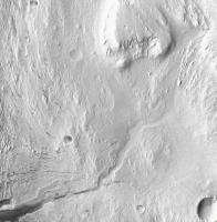
The more I look at the "headwaters" of the Mount Sharp channels the more it appears that the channels have been covered by the aeolian deposits that characterise the upper region of the mountain, rather than originating there. The inference is that the channels date from the early period where the crater was infilling and it is only recently (in martian terms) that the less consolidated material has been eroded away to reveal the lithified channels and deltas. An indication of the topography that would enable such channel formation is provided by Endeavour crater which has been overrun by sediment from the NW. If there was surface water flowing in Meridiani today it would possibly flow into the crater, cutting channels in the mound slope similar to those on Mount Sharp, terminating in a lake. Aeolian mountain building process and erosion like those proposed for Gale would then result in topography similar to the Gale channels/deltas, albeit on a much smaller scale.
Attached thumbnail(s)
|
|
|
|
|
|
|
Jul 1 2014, 09:10 AM
Post
#3
|
|
|
Junior Member Group: Members Posts: 33 Joined: 16-June 14 From: Sweet Home, Oregon Member No.: 7202 |
Reply to Serpens:
Your hypothesis (which we can christen the "overland-flow hypothesis") is not plausible, for several reasons: 1) To have such an overland flow which then poured down the northern and western sides of what was to become Mt. Sharp (carving the channels in the process), the eastern/southern portions of Gale Crater would have needed to be filled with sediments to the brim, forming a tableland....but if that were the case, why would the northern/western area of Gale Crater have been sediment-free? (which would have been needed to provide a basin into which the channels dumped their load). 2) Looking at the headwater of the Grand Canyon (seen in the image you pasted above), it is obvious that the channel is beginning at this point, as a juvenile channel that is both shallow and narrow, whereas if the (visible) Grand Canyon were a surviving remnant of what was originally a channel sourced from a great distance, flowing across a tableland (which has since eroded away), then it would have acquired the traits of a mature channel (full or near-full width and depth) LONG before the location of the Grand Canyon's visible headwater. 3) It HAS been suggested by other authors, possibly first by Anderson & Bell, that the Upper Formation was laid down on top of the lower mound AFTER the channels were carved. And this would indeed provide a possible mechanism for protecting the channels and their deltas from erosion and meteor impacts, until such time as these (presumably friable) sediments were stripped away via wind erosion. However, this is not plausible.....the surviving Upper Formation is at least reasonably lithified, as demonstrated by the crisp surface features visible in high-resolution photos of the mountain, including yardangs, ridges, steep topographic gradients such as scarps and cliff-bench layering, impact craters, and boulders in colluvium piles, all of which imply a hardened, indurated substrate (i.e., rock). If an underlying formation is covered by a later formation that is lithified to a comparable degree (one that is NOT friable and unconsolidated), then the stripping away of the overlying formation can be expected to inflict heavy damage to the lower (older) formation, as there would be no clear dividing line between the formations that would result in highly differential erosion. And if this had happened to the Mt. Sharp channel complex and fans, they would today be a mess, with some portions still obscured by their original sedimentary cover, other portions filled in or covered up by newer (reworked) materials, and still other portions gone forever as a result of erosional cross-cutting or systematic deflation of the landscape, in short a geologic hodge-podge that would require detailed stratigraphic research in order to decipher the original structure (if it even could be deciphered), rather than the channel complex being showcased before us in gleaming, near-mint condition (as it obviously is). And to suggest otherwise would actually involve a violation of the Second Law of Thermodynamics, since erosion is a very highly entropy-producing process, and cannot be expected to cleanly pluck away an overlying formation, almost grain by grain (as if by the Hand of God), without also doing great damage to the underlying formation. And there is no conceivable mechanism whereby the material that today constitutes the upper mound was lithified, but the outlying materials of the same formation were not (and so could be readily stripped away without substantially damaging the channel complex)....unless, of course, an artesian hydrant were present (as per my essay's main hypothesis) that would provide lithifying water exclusively to the sediments sitting on top of Mt. Sharp (i.e. the upper mound), in which case we also have a ready source for the water carving the channels, and the overland-flow hypothesis becomes redundant. Dave |
|
|
|
|
Jul 1 2014, 12:26 PM
Post
#4
|
|
|
Senior Member Group: Members Posts: 2346 Joined: 7-December 12 Member No.: 6780 |
QUOTE (David Palmer @ Jul 1 2014, 11:10 AM)  And there is no conceivable mechanism whereby the material that today constitutes the upper mound was lithified, but the outlying materials of the same formation were not ... I admit, that I didn't (yet) read all of your essay. But did you consider an ice cap or permafrost as a possible protective mechanism? This works at least for mountains on Earth. Lower parts tend to melt earlier, hence loose their protective property earlier, and are eroded faster. An ice cap could also explain the canyons, as e.g. fjords in polar regions on Earth. Then add the - currently I think mainstream - idea of slope winds, which are stronger at the base of the mount, and accelerate erosion further. The central mount has been higher, even after sedimentation due to the initial impact, this way starting the preferred erosion in the "low-lands". I don't claim this as the only possible explanation, but just to given an idea that there may be plenty of alternative conceivable mechanisms. Usually I avoid to discuss about the overall geomorpholgy of Gale, since I think finding "the" correct hypotheses without a huge amount of data and their deep analysis is like a lottery with a couple of tries within millions of possibilities, just think about the largely unknown climate on past Mars, e.g. due to the instability of the rotation axis (obliquity), add volcanism and large impacts. You might win the super-jackpot, but a-priori-chances are low. About the artesian spring hypothesis: Shouldn't there be obvious cenotes like in the Chicxulub region, due to leaching? And: How did the water manage to get out only at the mount, not at fractures somewhere else (think about the hydrostatic pressure), leaving several smaller mounts in the surroundings? |
|
|
|
 David Palmer geology of Gale Crater and Mount Sharp Jun 21 2014, 01:49 PM
 PDP8E Hi David,
What A fact filled first post!
Your... Jun 21 2014, 08:23 PM elakdawalla Hi David, it's clear you've put a lot of w... Jun 23 2014, 03:33 PM
PDP8E Hi David,
What A fact filled first post!
Your... Jun 21 2014, 08:23 PM elakdawalla Hi David, it's clear you've put a lot of w... Jun 23 2014, 03:33 PM
 David Palmer QUOTE (elakdawalla @ Jun 23 2014, 08:33 A... Jun 23 2014, 10:45 PM djellison QUOTE (David Palmer @ Jun 23 2014, 02:45 ... Jun 23 2014, 11:49 PM PDP8E my post (above) seems to have replicated itself...... Jun 23 2014, 09:01 PM elakdawalla Ah, my mistake, I did not notice the list of refer... Jun 24 2014, 12:09 AM djellison QUOTE (elakdawalla @ Jun 23 2014, 04:09 P... Jun 24 2014, 01:20 AM Juramike You've put a huge amount of work into this. I ... Jun 24 2014, 04:05 AM serpens Firstly let me congratulate you David, on the leve... Jun 24 2014, 08:04 AM David Palmer In response to Serpens:
My intention with my essa... Jun 24 2014, 02:08 PM elakdawalla My apologies, I completely misread your intent. Wh... Jun 24 2014, 06:18 PM djellison Of the entire 4 page work - this is the part that ... Jun 24 2014, 08:59 PM mcaplinger QUOTE a green-tinted sky similar to Curiositys...... Jun 24 2014, 09:56 PM David Palmer QUOTE (mcaplinger @ Jun 24 2014, 01:56 PM... Jun 24 2014, 10:43 PM djellison QUOTE (David Palmer @ Jun 24 2014, 02:43 ... Jun 24 2014, 10:51 PM David Palmer QUOTE (djellison @ Jun 24 2014, 12:59 PM)... Jun 24 2014, 11:05 PM fredk mcaplinger beat me - I was going to link to this p... Jun 24 2014, 10:10 PM serpens I think perhaps everyone needs to take a deep brea... Jun 25 2014, 12:30 AM David Palmer reply to Serpens:
I am very aware of the spring mo... Jun 25 2014, 01:22 AM serpens Dave, I am answering here rather than by email bec... Jun 27 2014, 03:44 AM David Palmer reply to Serpens:
The basis of my argument for the... Jun 27 2014, 04:07 AM Astro0 ADMIN NOTE:
EVERYONE - This discussion is breachi... Jun 25 2014, 01:10 AM vikingmars About the color of the Martian sky : we had alread... Jun 25 2014, 02:45 PM David Palmer reply to vikingmars ("About the color of the ... Jun 27 2014, 09:35 AM vikingmars QUOTE (David Palmer @ Jun 27 2014, 11:35 ... Jun 30 2014, 02:49 PM scalbers I can point here to my post in another thread, whe... Jun 29 2014, 06:40 PM marsophile Given the wide variation in the amount of dust, pe... Jun 30 2014, 04:02 AM mcaplinger QUOTE (marsophile @ Jun 29 2014, 09:02 PM... Jun 30 2014, 05:16 AM serpens QUOTE (mcaplinger @ Jun 30 2014, 06:16 AM... Jun 30 2014, 05:49 AM Astro0 ADMIN NOTE: All, as noted a few posts earlier, let... Jun 30 2014, 10:56 PM serpens I have a little difficulty with some of the assump... Jul 1 2014, 02:56 PM David Palmer Reply to Serpens:
Actually, I WANT "argument... Jul 1 2014, 09:33 PM ngunn QUOTE (David Palmer @ Jul 1 2014, 10:33 P... Jul 1 2014, 10:09 PM Gerald QUOTE (David Palmer @ Jul 1 2014, 11:33 P... Jul 1 2014, 11:12 PM David Palmer Reply to Gerald:
It is beyond my means to do a co... Jul 2 2014, 07:43 AM Gerald Picking out a couple of statements:
QUOTE (David P... Jul 2 2014, 12:12 PM David Palmer Reply to Gerald (my comments are in upper case): A... Jul 2 2014, 01:59 PM mcaplinger QUOTE (David Palmer @ Jul 1 2014, 02:33 P... Jul 2 2014, 03:13 PM David Palmer QUOTE (mcaplinger @ Jul 2 2014, 07:13 AM)... Jul 2 2014, 03:29 PM Gerald QUOTE (David Palmer @ Jul 2 2014, 05:29 P... Jul 2 2014, 05:30 PM David Palmer Reply to Gerald:
No, I did mean what I said, that... Jul 3 2014, 02:48 AM serpens ngunn provides some sage advice above. I commend ... Jul 2 2014, 02:52 PM serpens A slight aside. I wonder at the validity of using... Jul 2 2014, 11:17 PM Gerald That's why I would prefer to wait for more rel... Jul 3 2014, 12:20 AM David Palmer Reply to dialogue between Serpens and Gerald:
I d... Jul 3 2014, 03:36 AM serpens Apply Kite's model to the massive, upper stage... Jul 3 2014, 05:09 AM David Palmer Reply to Serpens:
There is quite a lot of ground ... Jul 3 2014, 12:11 PM Astro0 ADMIN NOTE:
Sorry everyone, I believe that this to... Jul 3 2014, 01:31 PM
David Palmer QUOTE (elakdawalla @ Jun 23 2014, 08:33 A... Jun 23 2014, 10:45 PM djellison QUOTE (David Palmer @ Jun 23 2014, 02:45 ... Jun 23 2014, 11:49 PM PDP8E my post (above) seems to have replicated itself...... Jun 23 2014, 09:01 PM elakdawalla Ah, my mistake, I did not notice the list of refer... Jun 24 2014, 12:09 AM djellison QUOTE (elakdawalla @ Jun 23 2014, 04:09 P... Jun 24 2014, 01:20 AM Juramike You've put a huge amount of work into this. I ... Jun 24 2014, 04:05 AM serpens Firstly let me congratulate you David, on the leve... Jun 24 2014, 08:04 AM David Palmer In response to Serpens:
My intention with my essa... Jun 24 2014, 02:08 PM elakdawalla My apologies, I completely misread your intent. Wh... Jun 24 2014, 06:18 PM djellison Of the entire 4 page work - this is the part that ... Jun 24 2014, 08:59 PM mcaplinger QUOTE a green-tinted sky similar to Curiositys...... Jun 24 2014, 09:56 PM David Palmer QUOTE (mcaplinger @ Jun 24 2014, 01:56 PM... Jun 24 2014, 10:43 PM djellison QUOTE (David Palmer @ Jun 24 2014, 02:43 ... Jun 24 2014, 10:51 PM David Palmer QUOTE (djellison @ Jun 24 2014, 12:59 PM)... Jun 24 2014, 11:05 PM fredk mcaplinger beat me - I was going to link to this p... Jun 24 2014, 10:10 PM serpens I think perhaps everyone needs to take a deep brea... Jun 25 2014, 12:30 AM David Palmer reply to Serpens:
I am very aware of the spring mo... Jun 25 2014, 01:22 AM serpens Dave, I am answering here rather than by email bec... Jun 27 2014, 03:44 AM David Palmer reply to Serpens:
The basis of my argument for the... Jun 27 2014, 04:07 AM Astro0 ADMIN NOTE:
EVERYONE - This discussion is breachi... Jun 25 2014, 01:10 AM vikingmars About the color of the Martian sky : we had alread... Jun 25 2014, 02:45 PM David Palmer reply to vikingmars ("About the color of the ... Jun 27 2014, 09:35 AM vikingmars QUOTE (David Palmer @ Jun 27 2014, 11:35 ... Jun 30 2014, 02:49 PM scalbers I can point here to my post in another thread, whe... Jun 29 2014, 06:40 PM marsophile Given the wide variation in the amount of dust, pe... Jun 30 2014, 04:02 AM mcaplinger QUOTE (marsophile @ Jun 29 2014, 09:02 PM... Jun 30 2014, 05:16 AM serpens QUOTE (mcaplinger @ Jun 30 2014, 06:16 AM... Jun 30 2014, 05:49 AM Astro0 ADMIN NOTE: All, as noted a few posts earlier, let... Jun 30 2014, 10:56 PM serpens I have a little difficulty with some of the assump... Jul 1 2014, 02:56 PM David Palmer Reply to Serpens:
Actually, I WANT "argument... Jul 1 2014, 09:33 PM ngunn QUOTE (David Palmer @ Jul 1 2014, 10:33 P... Jul 1 2014, 10:09 PM Gerald QUOTE (David Palmer @ Jul 1 2014, 11:33 P... Jul 1 2014, 11:12 PM David Palmer Reply to Gerald:
It is beyond my means to do a co... Jul 2 2014, 07:43 AM Gerald Picking out a couple of statements:
QUOTE (David P... Jul 2 2014, 12:12 PM David Palmer Reply to Gerald (my comments are in upper case): A... Jul 2 2014, 01:59 PM mcaplinger QUOTE (David Palmer @ Jul 1 2014, 02:33 P... Jul 2 2014, 03:13 PM David Palmer QUOTE (mcaplinger @ Jul 2 2014, 07:13 AM)... Jul 2 2014, 03:29 PM Gerald QUOTE (David Palmer @ Jul 2 2014, 05:29 P... Jul 2 2014, 05:30 PM David Palmer Reply to Gerald:
No, I did mean what I said, that... Jul 3 2014, 02:48 AM serpens ngunn provides some sage advice above. I commend ... Jul 2 2014, 02:52 PM serpens A slight aside. I wonder at the validity of using... Jul 2 2014, 11:17 PM Gerald That's why I would prefer to wait for more rel... Jul 3 2014, 12:20 AM David Palmer Reply to dialogue between Serpens and Gerald:
I d... Jul 3 2014, 03:36 AM serpens Apply Kite's model to the massive, upper stage... Jul 3 2014, 05:09 AM David Palmer Reply to Serpens:
There is quite a lot of ground ... Jul 3 2014, 12:11 PM Astro0 ADMIN NOTE:
Sorry everyone, I believe that this to... Jul 3 2014, 01:31 PM |

|
Lo-Fi Version | Time is now: 15th June 2024 - 01:51 PM |
|
RULES AND GUIDELINES Please read the Forum Rules and Guidelines before posting. IMAGE COPYRIGHT |
OPINIONS AND MODERATION Opinions expressed on UnmannedSpaceflight.com are those of the individual posters and do not necessarily reflect the opinions of UnmannedSpaceflight.com or The Planetary Society. The all-volunteer UnmannedSpaceflight.com moderation team is wholly independent of The Planetary Society. The Planetary Society has no influence over decisions made by the UnmannedSpaceflight.com moderators. |
SUPPORT THE FORUM Unmannedspaceflight.com is funded by the Planetary Society. Please consider supporting our work and many other projects by donating to the Society or becoming a member. |
|