Creating a Mars 3 Panorama, Not relying on the meaingless noise from the lander itself |

Creating a Mars 3 Panorama, Not relying on the meaingless noise from the lander itself |
 Dec 10 2014, 10:47 AM Dec 10 2014, 10:47 AM
Post
#1
|
||
 Junior Member  Group: Members Posts: 43 Joined: 14-December 12 Member No.: 6784 |
Being startled by the quality of the orbital images of the presumed Mars 3 landing site (rocks of diameter <50cm seem visible), I would like to simulate the view from the current location of the Mars 3 lander using a variety of sources. Below are a list of requirements to do this that I will attempt to fill in over time, with many questions included that I hope other users on UMSF may be able to point me in the right direction to answer. Any readers willing to help are gratefully accepted.
Requirements: Accurate 3D reconstruction of the Mars 3 lander, with emphasis on camera location and in-frame components - currently taking a look at the pre-existing 3D model found here but need to verify some details, anyone care to comment on accuracy? - where can I best find engineering drawings? - high-resolution photos? Condition of lander/rover - can any information about the rotation of the lander (emphasis on camera orientation) be derived from the HiRise images? - Q Answered: Prop-M deployed before imaging - what was the amount of dust in the atmosphere at landing time? - Q Answered: Height of camera above ground should be close to 75-80cm. Accurate camera behavior: - Q Answered: the camera is a optical-mechanical cycloramic camera - Q Answered: the field of view of the panorama is 30°x360° - Q Answered: each camera had a different permanent color filter, most likely one camera had an orange filter (OS14) and the other had a yellowgreen filer (ZhZS13). - Q Answered: automatic sensitivity control (ASC) ensuring image return within a wide range of luminance, from 50 to 50000 lux. - Q Answered: resolution of individual circular panorama 500x6000 pixels - were there any test-panorama images made on Earth and where are they? DEM of surroundings - Q Answered: a heightmap could be created from the stereo pair ESP_032447_1345 + ESP_032737_1345 - Q Answered: some experiments with commercial stereo-photogrammetry software - what is the best existing DEM for the surrounding terrain of Ptolomaeus crater? MOLA? HRSC DTM? Geology of the immediate surroundings - what sort of rocks/surface is expected to exist at this location? what previous lander location best compares? - are smaller rocks than visible in HiRise images anticipated but not visible due to resolution, or is there clearly a cut-off point of rocks below a certain diameter at the location? The attached quick mock-up gives an idea of what I would like to attempt. It is made using the aforementioned lander 3D model, a camera of arbitary vertical FOV positioned into one of the telephotometer enclosures, stitch of several renders, one of the HiRise images overlaid into Google Mars and the terrain elevation data from Google Mars in the background, intended only as a demonstration. The visible "rock" is also a test and its height and width are estimated from the shadow it casts relative to that of the lander with known height.
Attached thumbnail(s)
|
|
 |
 
|
|
 |
| Guest_alex_k_* |
Dec 10 2014, 04:49 PM
Post
#2
|
|
Guests |
Hi Sittingduck,
Have you seen these two works (in Russian)? 1. http://habrahabr.ru/post/204562 2. http://scienceandtec.ucoz.ru/forum/2-1-1 (extra views: http://scienceandtec.ucoz.ru/photo/fotokarty_marsa/6) For your questions: - High-res photos can be found in museums: https://www.google.com/search?tbm=isch&...-3%22&cad=h - Some information about the cameras can be found in the Selivanov's article: http://libgen.org/scimag5/10.1134/S0038094613030064.pdf . Also I'd recommend the article (in Russian) about the camera of "Luna-9" which was at most similar: http://www.kik-sssr.ru/AMS_E-6.htm - HiRise stereopair are ESP_032447_1345 and ESP_032737_1345 . There're four HiRise images of the lander. - About EDL hardware, take a look at the photo: http://www.unmannedspaceflight.com/index.p...st&p=199188 - About the geology, there was an opinion that the type of landing site is close to polar areas shown by Phoenix. - About 1.2m height, I think it's size with the cover. Take a look at the picture: http://www.unmannedspaceflight.com/index.p...st&p=201190 I estimate the height from surface to camera about 80 cm. Best wishes! upd. Two points about your picture: 1. The cameras were tilted like at Luna-9, -13 and Veneras so the horizon can't be straight. 2. Most probably that Prop-M rover was deployed: transmission of the panorama should follow the deployment of scientific instruments. |
|
|
|
|
Dec 10 2014, 05:11 PM
Post
#3
|
|
|
Junior Member Group: Members Posts: 43 Joined: 14-December 12 Member No.: 6784 |
QUOTE (alex_k @ Dec 10 2014, 05:49 PM)  Have you seen these two works (in Russian)? 1. http://habrahabr.ru/post/204562 2. http://scienceandtec.ucoz.ru/forum/2-1-1 (extra views: http://scienceandtec.ucoz.ru/photo/fotokarty_marsa/6) Wow, thank you. No I hadn't seen them, but that's really what I wanted to do. Guess there isn't much point left in it  edit: It looks like it is still possible to create a more accurate/life-like panorama though, so I may continue. edit2: was it expected for the 'cone' to always land so near the lander itself as in that test photograph? |
|
|
|
| Guest_alex_k_* |
Dec 11 2014, 08:48 AM
Post
#4
|
|
|
Guests |
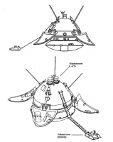
QUOTE (sittingduck @ Dec 10 2014, 10:11 PM) edit: It looks like it is still possible to create a more accurate/life-like panorama though, so I may continue. It's very interesting to get a detailed altitudes map of four HiRise sources. A kind of superresolution in 3d. Of couse it's possible to apply a 2d supperresolution texture to 3d map made of stereopair. QUOTE (sittingduck @ Dec 10 2014, 10:11 PM) edit2: was it expected for the 'cone' to always land so near the lander itself as in that test photograph? I don't know. But martian gravity is less so the cover can be further. upd: In my archive I've found a schematic picture of the lander. Not an engineer drawing, but maybe it will help.
|
|
|
|
|
|
 sittingduck Creating a Mars 3 Panorama Dec 10 2014, 10:47 AM
 vikingmars QUOTE (sittingduck @ Dec 10 2014, 11:47 A... Dec 10 2014, 03:24 PM
 alex_k QUOTE (sittingduck @ Dec 10 2014, 10:11 P... Dec 10 2014, 05:24 PM 4throck Those line scanning cycloramic cameras don't g... Dec 10 2014, 06:04 PM alex_k QUOTE - can any information about the rotation of ... Dec 11 2014, 02:27 PM
 sittingduck Alex_k,
Thanks for the schematic and more info... Dec 11 2014, 06:14 PM alex_k QUOTE (sittingduck @ Dec 11 2014, 11:14 P... Dec 12 2014, 01:22 PM 4th rock from the sun You may assume that the tilt is the same as with t... Dec 12 2014, 02:22 PM PDP8E At one point in time last year, I was using the ... Dec 13 2014, 04:55 AM rlorenz QUOTE (sittingduck @ Dec 10 2014, 05:47 A... Dec 13 2014, 02:20 PM sittingduck Great image PDP8E, that will help me narrow down t... Dec 14 2014, 08:31 PM alex_k For a research purpose I need an exact DEM of Mars... Aug 14 2015, 08:26 AM
sittingduck Alex_k,
Thanks for the schematic and more info... Dec 11 2014, 06:14 PM alex_k QUOTE (sittingduck @ Dec 11 2014, 11:14 P... Dec 12 2014, 01:22 PM 4th rock from the sun You may assume that the tilt is the same as with t... Dec 12 2014, 02:22 PM PDP8E At one point in time last year, I was using the ... Dec 13 2014, 04:55 AM rlorenz QUOTE (sittingduck @ Dec 10 2014, 05:47 A... Dec 13 2014, 02:20 PM sittingduck Great image PDP8E, that will help me narrow down t... Dec 14 2014, 08:31 PM alex_k For a research purpose I need an exact DEM of Mars... Aug 14 2015, 08:26 AM |

|
Lo-Fi Version | Time is now: 25th May 2024 - 11:06 AM |
|
RULES AND GUIDELINES Please read the Forum Rules and Guidelines before posting. IMAGE COPYRIGHT |
OPINIONS AND MODERATION Opinions expressed on UnmannedSpaceflight.com are those of the individual posters and do not necessarily reflect the opinions of UnmannedSpaceflight.com or The Planetary Society. The all-volunteer UnmannedSpaceflight.com moderation team is wholly independent of The Planetary Society. The Planetary Society has no influence over decisions made by the UnmannedSpaceflight.com moderators. |
SUPPORT THE FORUM Unmannedspaceflight.com is funded by the Planetary Society. Please consider supporting our work and many other projects by donating to the Society or becoming a member. |
|