Dawn approaches Ceres, From opnav images to first orbit |

Dawn approaches Ceres, From opnav images to first orbit |
 Jan 12 2015, 12:10 AM Jan 12 2015, 12:10 AM
Post
#1
|
||
|
Solar System Cartographer  Group: Members Posts: 10184 Joined: 5-April 05 From: Canada Member No.: 227 |
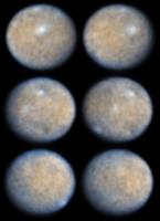
On Tuesday (two days from now, for visitors from the future), the first optical navigation image will be taken... hopefully we'll have it in our hands soon after that. So it's time for a new topic. Over the next few months we'll have progressively closer images and full orbit characterization sequences, no doubt including multispectral image sets.
A new world... This is a bit of reprocessing I have been doing with the Hubble images from a few years ago.
Phil -------------------- ... because the Solar System ain't gonna map itself.
Also to be found posting similar content on https://mastodon.social/@PhilStooke Maps for download (free PD: https://upload.wikimedia.org/wikipedia/comm...Cartography.pdf NOTE: everything created by me which I post on UMSF is considered to be in the public domain (NOT CC, public domain) |
|
 |
 
|
|
 |
|
Jan 24 2015, 04:42 PM
Post
#2
|
|
 Senior Member Group: Members Posts: 4251 Joined: 17-January 05 Member No.: 152 |
When you view an animated gif of the released set your brain can pull real structure out of the noise, and you end up seeing more structure than in any single frame. This makes me wonder about producing a super-res from this set. It would be a lot of work. You'd have to create a rotation model and transform each image into some fixed projection, before doing the stacking with each frame aligned in longitude. Of course you'd get maximal improvement near the central region of the central frame, and less improvement towards the edges. Still, it would be interesting to see what could be done.
Or you could wait for the next release... |
|
|
|
|
Jan 25 2015, 01:34 PM
Post
#3
|
|||
 IMG to PNG GOD Group: Moderator Posts: 2251 Joined: 19-February 04 From: Near fire and ice Member No.: 38 |
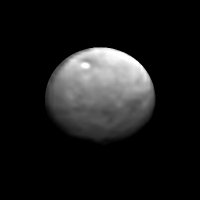
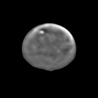
QUOTE (fredk @ Jan 24 2015, 04:42 PM)  ...This makes me wonder about producing a super-res from this set. It would be a lot of work. You'd have to create a rotation model and transform each image into some fixed projection... I originally wasn't going to spend any time doing this since there isn't a long time until the next images arrive but I found that I simply couldn't resist checking if more details could be revealed, also this was an interesting image processing experiment. I used the last 9 images from the set, reprojected them to simple cylindrical projection and then aligned and stacked the maps. This was followed by rendering an ellipsoid using the map as a texture map. I was rather disappointed with the result and I'm not sure which 'new' details are real, maybe some but maybe none. Below are two versions, the left one sharpened with an unsharp mask and the right one processed with a high pass filter followed by a contrast stretch:
I'm more happy with the version at left. The most interesting feature is the one below center that stretches from the left limb and more than half the way to the right limb. This looks like a possible 'depression' (reminds me a bit of Tethys' Ithaca Chasma!?) but an albedo feature (or something else) can't be ruled out. One important caveat is that the images in the rotation movie have been processed and enlarged - I'd me more confident in these results if I was using the original, raw images. It should be mentioned that the original 20 images were obtained over a period of ~1 hour at a range of 383,000 km and the subspacecraft latitude is 28.2 degrees south. |
||
|
|
|
||
 Phil Stooke Dawn approaches Ceres Jan 12 2015, 12:10 AM
 MizarKey I very excited to see this little world better. N... Jan 12 2015, 02:48 AM vikingmars QUOTE (Phil Stooke @ Jan 12 2015, 01:10 A... Jan 12 2015, 08:22 AM
 tedstryk Beautiful! I've fooled with this dataset ... Jan 12 2015, 12:35 PM Phil Stooke This is a cylindrical map made from those images. ... Jan 12 2015, 05:59 PM DrShank Very Nice!
can i post it on my blog later to... Jan 13 2015, 12:46 PM 4th rock from the sun Great map!
Besides the lighter patches I see ... Jan 13 2015, 12:57 PM Phil Stooke Hi Paul - by all means post it. It's not as n... Jan 13 2015, 02:01 PM DrShank I am most intrigued by the apparent 'bluing... Jan 13 2015, 04:37 PM Phil Stooke In the single images, it's bluer near the limb... Jan 13 2015, 04:46 PM DrShank true. but some of the images seem to show stronge... Jan 13 2015, 06:02 PM PDP8E Dawn is supposed to take another Ceres image today... Jan 13 2015, 07:15 PM Mithridates It's now the evening of the 13th. Is it safe t... Jan 14 2015, 03:40 AM Decepticon The image that was taken Dec 1,2014 took 7 or 8 da... Jan 14 2015, 04:26 AM Phil Stooke "Is it safe to say that the Dawn team is look... Jan 14 2015, 02:13 PM Superstring Is every image during approach going to be delayed... Jan 14 2015, 10:55 PM djellison QUOTE (Superstring @ Jan 14 2015, 02:55 P... Jan 14 2015, 11:33 PM Explorer1 Pretty sure it was like that for Vesta too; thrust... Jan 14 2015, 10:57 PM DrShank QUOTE (Explorer1 @ Jan 14 2015, 04:57 PM)... Jan 15 2015, 12:26 AM TheAnt QUOTE (DrShank @ Jan 15 2015, 01:26 AM) O... Jan 15 2015, 12:07 PM DrShank QUOTE (TheAnt @ Jan 15 2015, 06:07 AM) Cl... Jan 15 2015, 12:13 PM TheAnt QUOTE (DrShank @ Jan 15 2015, 01:13 PM) y... Jan 15 2015, 03:53 PM DrShank QUOTE (TheAnt @ Jan 15 2015, 09:53 AM) Oh... Jan 15 2015, 11:57 PM TheAnt QUOTE (DrShank @ Jan 16 2015, 12:57 AM) .... Jan 16 2015, 10:53 PM DrShank QUOTE (TheAnt @ Jan 16 2015, 04:53 PM) ... Jan 16 2015, 11:46 PM Superstring Ah, I guess my memory from the Vesta encounter is ... Jan 14 2015, 11:42 PM Mithridates During Vesta approach Dawn did the following:
htt... Jan 14 2015, 11:52 PM elakdawalla Because of the severe limitations imposed on the m... Jan 15 2015, 12:24 AM Mithridates QUOTE (elakdawalla @ Jan 15 2015, 12:24 A... Jan 15 2015, 12:57 AM djellison QUOTE (Mithridates @ Jan 14 2015, 04:57 P... Jan 15 2015, 01:07 AM Explorer1 Wonder no more: I have a strange sense that an ima... Jan 15 2015, 01:25 AM Mithridates Nice! I was looking at that Twitter feed earli... Jan 15 2015, 01:30 AM DrShank QUOTE (Mithridates @ Jan 14 2015, 07:30 P... Jan 15 2015, 03:46 AM elakdawalla Moved a bunch of pronunciation posts to the Junk D... Jan 15 2015, 03:57 PM nprev Paul, you may know this right off the bat: Where d... Jan 16 2015, 11:53 PM Tom Tamlyn QUOTE (nprev @ Jan 16 2015, 06:53 PM) * *... Jan 22 2015, 07:13 AM Phil Stooke http://www.jpl.nasa.gov/news/news.php?feature=4449... Jan 19 2015, 04:35 PM nprev Oh, boy; here we go!!!
Looks like th... Jan 19 2015, 04:51 PM Explorer1 Yeah, that spot seems like a crater; I can almost ... Jan 19 2015, 04:57 PM Habukaz My layman-self is a bit confused.
This picture h... Jan 19 2015, 05:56 PM Hungry4info Comparing the new Dawn images to an HST image, I t... Jan 19 2015, 06:19 PM Phil Stooke replying to Habukaz - At this resolution you can... Jan 19 2015, 06:20 PM Habukaz QUOTE (Phil Stooke @ Jan 19 2015, 07:20 P... Jan 19 2015, 06:44 PM Holder of the Two Leashes But I think the operative word there is "hint... Jan 19 2015, 06:56 PM Habukaz QUOTE (Holder of the Two Leashes @ Jan 19 201... Jan 19 2015, 07:09 PM elakdawalla Chitchatting with other people here at the New Hor... Jan 19 2015, 07:10 PM MarkG Spectacular pictures! Wild cheering from the ... Jan 19 2015, 07:52 PM Bjorn Jonsson It's interesting that even though the resoluti... Jan 20 2015, 12:32 AM elakdawalla Bjorn, what you said is pretty much what the New H... Jan 20 2015, 02:54 AM dvandorn These images, and especially the animation made fr... Jan 20 2015, 04:43 AM Habukaz QUOTE (dvandorn @ Jan 20 2015, 05:43 AM) ... Jan 20 2015, 10:14 AM dvandorn QUOTE (Habukaz @ Jan 20 2015, 04:14 AM) C... Jan 21 2015, 03:33 AM TheAnt QUOTE (dvandorn @ Jan 20 2015, 05:43 AM) ... Jan 20 2015, 05:08 PM alex_k An attempt to process raw image, x8, details are e... Jan 20 2015, 06:40 AM Fran Ontanaya Very crude attempt at overlaying HST and Dawn
Jan 20 2015, 08:55 AM Phil Stooke There was so much mixing going on that the differe... Jan 20 2015, 03:46 PM elakdawalla I assumed that the flickering of the animation was... Jan 20 2015, 05:24 PM Astroboy Can we call the faint smudge the Little White Spot... Jan 20 2015, 05:33 PM Phil Stooke I edited my map comparison, just above, to correct... Jan 20 2015, 10:01 PM Gladstoner So far it reminds me of Umbriel. Jan 20 2015, 10:50 PM Astro0 Can't wait for the next image to come in
W... Jan 21 2015, 04:29 AM vikingmars QUOTE (Astro0 @ Jan 21 2015, 05:29 AM) .... Jan 22 2015, 12:57 PM Habukaz QUOTE (vikingmars @ Jan 22 2015, 01:57 PM... Jan 22 2015, 02:21 PM climber QUOTE (vikingmars @ Jan 22 2015, 01:57 PM... Jan 22 2015, 02:33 PM vikingmars QUOTE (climber @ Jan 22 2015, 03:33 PM) .... Jan 22 2015, 04:26 PM Explorer1 Well, here's one idea:
http://xkcd.com/1476/ Jan 21 2015, 05:50 AM Habukaz Those replies about Ceres' formation is someth... Jan 21 2015, 12:42 PM DrShank hey ho!
was busy at a New Horizons meeting all... Jan 21 2015, 04:21 PM Sherbert The comparisons with Pluto and Charon will be inte... Jan 21 2015, 07:38 PM Explorer1 I believe that what they mean by 'so fast... Jan 22 2015, 08:24 AM Tom Tamlyn QUOTE (Explorer1 @ Jan 22 2015, 03:24 AM)... Jan 22 2015, 10:38 AM belleraphon1 This ESA press release on HERSCHEL discovery of Ce... Jan 22 2015, 01:04 PM Phil Stooke
My longitudes look like they are a bit off. I... Jan 22 2015, 01:48 PM belleraphon1 Thanks Phil...
If Region A contains the bright s... Jan 22 2015, 02:20 PM hendric Just for my own curiosity, I looked at if Dawn cou... Jan 22 2015, 04:45 PM djellison Each of Dawn's 12 RCS thrusters are I believe ... Jan 22 2015, 06:17 PM DrShank thats right. no soft landing. no way to slow dow... Jan 23 2015, 02:29 PM algorimancer Wasn't there discussion of Dawn possibly going... Jan 23 2015, 02:45 PM K-P QUOTE (algorimancer @ Jan 23 2015, 04:45 ... Jan 23 2015, 04:01 PM Phil Stooke I don't know if that was discussed as a vague ... Jan 23 2015, 02:55 PM DrShank QUOTE (Phil Stooke @ Jan 23 2015, 08:55 A... Jan 23 2015, 03:12 PM TheAnt QUOTE (DrShank @ Jan 23 2015, 04:12 PM) a... Jan 23 2015, 04:16 PM Habukaz QUOTE (TheAnt @ Jan 23 2015, 05:16 PM) So... Jan 23 2015, 04:28 PM TheAnt QUOTE (Habukaz @ Jan 23 2015, 05:28 PM) I... Jan 23 2015, 05:42 PM algorimancer It sounds pretty settled. Leaving Dawn in a stabl... Jan 23 2015, 08:33 PM Mithridates QUOTE (algorimancer @ Jan 23 2015, 08:33 ... Jan 24 2015, 06:11 AM DrShank QUOTE (Mithridates @ Jan 24 2015, 12:11 A... Jan 24 2015, 01:42 PM MarsInMyLifetime If only for a spare hole in the filter wheel that ... Jan 24 2015, 08:05 PM DrShank GRAND basically observes the whole planet at one t... Jan 23 2015, 08:54 PM elakdawalla Continuing operations as long as possible in the l... Jan 23 2015, 09:29 PM dvandorn Great work, Bjorn!
It seems obvious that the ... Jan 25 2015, 04:50 PM fredk Very cool to see this, Bjorn. As important as any... Jan 25 2015, 05:33 PM Bjorn Jonsson Looking at the movie and other versions of the ima... Jan 25 2015, 05:40 PM Sherbert Very nicely done Bjorn.
I think there could be t... Jan 25 2015, 09:59 PM machi QUOTE (Bjorn Jonsson @ Jan 25 2015, 02:34... Jan 25 2015, 11:45 PM DrShank All very interesting speculations. I've wonde... Jan 26 2015, 12:17 AM Habukaz The first new Ceres images are coming down, and th... Jan 26 2015, 04:40 PM
tedstryk Beautiful! I've fooled with this dataset ... Jan 12 2015, 12:35 PM Phil Stooke This is a cylindrical map made from those images. ... Jan 12 2015, 05:59 PM DrShank Very Nice!
can i post it on my blog later to... Jan 13 2015, 12:46 PM 4th rock from the sun Great map!
Besides the lighter patches I see ... Jan 13 2015, 12:57 PM Phil Stooke Hi Paul - by all means post it. It's not as n... Jan 13 2015, 02:01 PM DrShank I am most intrigued by the apparent 'bluing... Jan 13 2015, 04:37 PM Phil Stooke In the single images, it's bluer near the limb... Jan 13 2015, 04:46 PM DrShank true. but some of the images seem to show stronge... Jan 13 2015, 06:02 PM PDP8E Dawn is supposed to take another Ceres image today... Jan 13 2015, 07:15 PM Mithridates It's now the evening of the 13th. Is it safe t... Jan 14 2015, 03:40 AM Decepticon The image that was taken Dec 1,2014 took 7 or 8 da... Jan 14 2015, 04:26 AM Phil Stooke "Is it safe to say that the Dawn team is look... Jan 14 2015, 02:13 PM Superstring Is every image during approach going to be delayed... Jan 14 2015, 10:55 PM djellison QUOTE (Superstring @ Jan 14 2015, 02:55 P... Jan 14 2015, 11:33 PM Explorer1 Pretty sure it was like that for Vesta too; thrust... Jan 14 2015, 10:57 PM DrShank QUOTE (Explorer1 @ Jan 14 2015, 04:57 PM)... Jan 15 2015, 12:26 AM TheAnt QUOTE (DrShank @ Jan 15 2015, 01:26 AM) O... Jan 15 2015, 12:07 PM DrShank QUOTE (TheAnt @ Jan 15 2015, 06:07 AM) Cl... Jan 15 2015, 12:13 PM TheAnt QUOTE (DrShank @ Jan 15 2015, 01:13 PM) y... Jan 15 2015, 03:53 PM DrShank QUOTE (TheAnt @ Jan 15 2015, 09:53 AM) Oh... Jan 15 2015, 11:57 PM TheAnt QUOTE (DrShank @ Jan 16 2015, 12:57 AM) .... Jan 16 2015, 10:53 PM DrShank QUOTE (TheAnt @ Jan 16 2015, 04:53 PM) ... Jan 16 2015, 11:46 PM Superstring Ah, I guess my memory from the Vesta encounter is ... Jan 14 2015, 11:42 PM Mithridates During Vesta approach Dawn did the following:
htt... Jan 14 2015, 11:52 PM elakdawalla Because of the severe limitations imposed on the m... Jan 15 2015, 12:24 AM Mithridates QUOTE (elakdawalla @ Jan 15 2015, 12:24 A... Jan 15 2015, 12:57 AM djellison QUOTE (Mithridates @ Jan 14 2015, 04:57 P... Jan 15 2015, 01:07 AM Explorer1 Wonder no more: I have a strange sense that an ima... Jan 15 2015, 01:25 AM Mithridates Nice! I was looking at that Twitter feed earli... Jan 15 2015, 01:30 AM DrShank QUOTE (Mithridates @ Jan 14 2015, 07:30 P... Jan 15 2015, 03:46 AM elakdawalla Moved a bunch of pronunciation posts to the Junk D... Jan 15 2015, 03:57 PM nprev Paul, you may know this right off the bat: Where d... Jan 16 2015, 11:53 PM Tom Tamlyn QUOTE (nprev @ Jan 16 2015, 06:53 PM) * *... Jan 22 2015, 07:13 AM Phil Stooke http://www.jpl.nasa.gov/news/news.php?feature=4449... Jan 19 2015, 04:35 PM nprev Oh, boy; here we go!!!
Looks like th... Jan 19 2015, 04:51 PM Explorer1 Yeah, that spot seems like a crater; I can almost ... Jan 19 2015, 04:57 PM Habukaz My layman-self is a bit confused.
This picture h... Jan 19 2015, 05:56 PM Hungry4info Comparing the new Dawn images to an HST image, I t... Jan 19 2015, 06:19 PM Phil Stooke replying to Habukaz - At this resolution you can... Jan 19 2015, 06:20 PM Habukaz QUOTE (Phil Stooke @ Jan 19 2015, 07:20 P... Jan 19 2015, 06:44 PM Holder of the Two Leashes But I think the operative word there is "hint... Jan 19 2015, 06:56 PM Habukaz QUOTE (Holder of the Two Leashes @ Jan 19 201... Jan 19 2015, 07:09 PM elakdawalla Chitchatting with other people here at the New Hor... Jan 19 2015, 07:10 PM MarkG Spectacular pictures! Wild cheering from the ... Jan 19 2015, 07:52 PM Bjorn Jonsson It's interesting that even though the resoluti... Jan 20 2015, 12:32 AM elakdawalla Bjorn, what you said is pretty much what the New H... Jan 20 2015, 02:54 AM dvandorn These images, and especially the animation made fr... Jan 20 2015, 04:43 AM Habukaz QUOTE (dvandorn @ Jan 20 2015, 05:43 AM) ... Jan 20 2015, 10:14 AM dvandorn QUOTE (Habukaz @ Jan 20 2015, 04:14 AM) C... Jan 21 2015, 03:33 AM TheAnt QUOTE (dvandorn @ Jan 20 2015, 05:43 AM) ... Jan 20 2015, 05:08 PM alex_k An attempt to process raw image, x8, details are e... Jan 20 2015, 06:40 AM Fran Ontanaya Very crude attempt at overlaying HST and Dawn
Jan 20 2015, 08:55 AM Phil Stooke There was so much mixing going on that the differe... Jan 20 2015, 03:46 PM elakdawalla I assumed that the flickering of the animation was... Jan 20 2015, 05:24 PM Astroboy Can we call the faint smudge the Little White Spot... Jan 20 2015, 05:33 PM Phil Stooke I edited my map comparison, just above, to correct... Jan 20 2015, 10:01 PM Gladstoner So far it reminds me of Umbriel. Jan 20 2015, 10:50 PM Astro0 Can't wait for the next image to come in
W... Jan 21 2015, 04:29 AM vikingmars QUOTE (Astro0 @ Jan 21 2015, 05:29 AM) .... Jan 22 2015, 12:57 PM Habukaz QUOTE (vikingmars @ Jan 22 2015, 01:57 PM... Jan 22 2015, 02:21 PM climber QUOTE (vikingmars @ Jan 22 2015, 01:57 PM... Jan 22 2015, 02:33 PM vikingmars QUOTE (climber @ Jan 22 2015, 03:33 PM) .... Jan 22 2015, 04:26 PM Explorer1 Well, here's one idea:
http://xkcd.com/1476/ Jan 21 2015, 05:50 AM Habukaz Those replies about Ceres' formation is someth... Jan 21 2015, 12:42 PM DrShank hey ho!
was busy at a New Horizons meeting all... Jan 21 2015, 04:21 PM Sherbert The comparisons with Pluto and Charon will be inte... Jan 21 2015, 07:38 PM Explorer1 I believe that what they mean by 'so fast... Jan 22 2015, 08:24 AM Tom Tamlyn QUOTE (Explorer1 @ Jan 22 2015, 03:24 AM)... Jan 22 2015, 10:38 AM belleraphon1 This ESA press release on HERSCHEL discovery of Ce... Jan 22 2015, 01:04 PM Phil Stooke
My longitudes look like they are a bit off. I... Jan 22 2015, 01:48 PM belleraphon1 Thanks Phil...
If Region A contains the bright s... Jan 22 2015, 02:20 PM hendric Just for my own curiosity, I looked at if Dawn cou... Jan 22 2015, 04:45 PM djellison Each of Dawn's 12 RCS thrusters are I believe ... Jan 22 2015, 06:17 PM DrShank thats right. no soft landing. no way to slow dow... Jan 23 2015, 02:29 PM algorimancer Wasn't there discussion of Dawn possibly going... Jan 23 2015, 02:45 PM K-P QUOTE (algorimancer @ Jan 23 2015, 04:45 ... Jan 23 2015, 04:01 PM Phil Stooke I don't know if that was discussed as a vague ... Jan 23 2015, 02:55 PM DrShank QUOTE (Phil Stooke @ Jan 23 2015, 08:55 A... Jan 23 2015, 03:12 PM TheAnt QUOTE (DrShank @ Jan 23 2015, 04:12 PM) a... Jan 23 2015, 04:16 PM Habukaz QUOTE (TheAnt @ Jan 23 2015, 05:16 PM) So... Jan 23 2015, 04:28 PM TheAnt QUOTE (Habukaz @ Jan 23 2015, 05:28 PM) I... Jan 23 2015, 05:42 PM algorimancer It sounds pretty settled. Leaving Dawn in a stabl... Jan 23 2015, 08:33 PM Mithridates QUOTE (algorimancer @ Jan 23 2015, 08:33 ... Jan 24 2015, 06:11 AM DrShank QUOTE (Mithridates @ Jan 24 2015, 12:11 A... Jan 24 2015, 01:42 PM MarsInMyLifetime If only for a spare hole in the filter wheel that ... Jan 24 2015, 08:05 PM DrShank GRAND basically observes the whole planet at one t... Jan 23 2015, 08:54 PM elakdawalla Continuing operations as long as possible in the l... Jan 23 2015, 09:29 PM dvandorn Great work, Bjorn!
It seems obvious that the ... Jan 25 2015, 04:50 PM fredk Very cool to see this, Bjorn. As important as any... Jan 25 2015, 05:33 PM Bjorn Jonsson Looking at the movie and other versions of the ima... Jan 25 2015, 05:40 PM Sherbert Very nicely done Bjorn.
I think there could be t... Jan 25 2015, 09:59 PM machi QUOTE (Bjorn Jonsson @ Jan 25 2015, 02:34... Jan 25 2015, 11:45 PM DrShank All very interesting speculations. I've wonde... Jan 26 2015, 12:17 AM Habukaz The first new Ceres images are coming down, and th... Jan 26 2015, 04:40 PM |

|
Lo-Fi Version | Time is now: 5th June 2024 - 08:37 AM |
|
RULES AND GUIDELINES Please read the Forum Rules and Guidelines before posting. IMAGE COPYRIGHT |
OPINIONS AND MODERATION Opinions expressed on UnmannedSpaceflight.com are those of the individual posters and do not necessarily reflect the opinions of UnmannedSpaceflight.com or The Planetary Society. The all-volunteer UnmannedSpaceflight.com moderation team is wholly independent of The Planetary Society. The Planetary Society has no influence over decisions made by the UnmannedSpaceflight.com moderators. |
SUPPORT THE FORUM Unmannedspaceflight.com is funded by the Planetary Society. Please consider supporting our work and many other projects by donating to the Society or becoming a member. |
|