Galileo images and mosaics of Europa |

Galileo images and mosaics of Europa |
 Aug 22 2005, 04:03 AM Aug 22 2005, 04:03 AM
Post
#101
|
|
 Interplanetary Dumpster Diver  Group: Admin Posts: 4404 Joined: 17-February 04 From: Powell, TN Member No.: 33 |
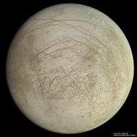
I have worked on sprucing up some global views of Europa from Galileo. There are a few more global views I hope to get to eventually. But the best two at nearly full phase benefited a lot.
 [Moderator note: There are several more threads containing Galileo Europa images but they all contain several inactive image links. The main threads are: http://www.unmannedspaceflight.com/index.php?showtopic=2016 http://www.unmannedspaceflight.com/index.php?showtopic=2174 http://www.unmannedspaceflight.com/index.php?showtopic=2222 http://www.unmannedspaceflight.com/index.php?showtopic=2082 http://www.unmannedspaceflight.com/index.php?showtopic=2142 ] -------------------- |
 |
 
|
 |
|
Feb 2 2015, 10:40 PM
Post
#102
|
||
 IMG to PNG GOD Group: Moderator Posts: 2254 Joined: 19-February 04 From: Near fire and ice Member No.: 38 |
Today, it seems that NASA is at last committing to flying a mission (probably Europa Clipper) to Europa after years of studies. By a strange conincidence, on this same day I may have finally finished the 20000x10000 pixel map of Europa I've been working on for almost 2 years (!) (but with major breaks to do several smaller projects). All that remains is to check for images I might have overlooked that I should have included in the map (I don't expect to find any). The map should include almost every image down to a resolution of ~200 m/pixel plus a selection of several higher-res images.
Here is a 4000x4000 pixel test render showing the hemisphere with the best imaging coverage, including a pole-to-pole strip left of center at higher resolution than most of the map.
Due to upload size limitations I couldn't upload a bigger version here; a bigger (6000x6000 pixels) version can be seen here: http://www.mmedia.is/bjj/data/europa/europ...b_6000x6000.jpg I'm looking forward to the day when *all* of this terrain has been imaged at better resolution than here by JUICE and/or Europa Clipper. I want my Europa map to become completely outdated as soon as possible! |
|
|
|
|
|
|
Feb 3 2015, 01:21 AM
Post
#103
|
|
|
Senior Member Group: Members Posts: 1591 Joined: 14-October 05 From: Vermont Member No.: 530 |
QUOTE (Bjorn Jonsson @ Feb 2 2015, 05:40 PM)  Here is a 4000x4000 pixel test render showing the hemisphere with the best imaging coverage, including a pole-to-pole strip left of center at higher resolution than most of the map. I noticed that and assumed that was where Galileo had images things at a higher resolution... am I to understand to that the entire hemisphere has similar resolution in your map? Wow. |
|
|
|
 tedstryk Galileo images and mosaics of Europa Aug 22 2005, 04:03 AM
 volcanopele I hate to burst everyone's bubble, but one of ... Oct 27 2011, 04:45 AM machi QUOTE (Bjorn Jonsson @ Oct 27 2011, 11:55... Oct 27 2011, 12:23 PM machi New stereograms (both anaglyph and cross-eye versi... Oct 31 2011, 02:12 PM Bjorn Jonsson Wow, this looks awesome, both the images/mosaics a... Nov 1 2011, 12:16 AM machi Thanks,
Accuracy of the stereograms Fig.5 and Fig.... Nov 1 2011, 05:39 AM
volcanopele I hate to burst everyone's bubble, but one of ... Oct 27 2011, 04:45 AM machi QUOTE (Bjorn Jonsson @ Oct 27 2011, 11:55... Oct 27 2011, 12:23 PM machi New stereograms (both anaglyph and cross-eye versi... Oct 31 2011, 02:12 PM Bjorn Jonsson Wow, this looks awesome, both the images/mosaics a... Nov 1 2011, 12:16 AM machi Thanks,
Accuracy of the stereograms Fig.5 and Fig.... Nov 1 2011, 05:39 AM ElkGroveDan QUOTE (machi @ Oct 31 2011, 10:39 PM) Wit... Nov 1 2011, 01:19 PM
 DrShank QUOTE (machi @ Nov 1 2011, 12:39 AM) Than... Sep 5 2014, 08:08 PM tedstryk NASA has released an exquisite new version of Gali... Nov 21 2014, 08:14 PM machi I'm pleased, that someone has clue, how painfu... Nov 1 2011, 05:53 PM jasedm Your pain is our gain!
Awesome, thanks. Nov 1 2011, 06:30 PM tedstryk To celebrate the selection of JUICE, I have a new ... May 3 2012, 04:42 PM Bjorn Jonsson Very nice image that initially confused me a lot s... May 5 2012, 01:40 PM tedstryk QUOTE (Bjorn Jonsson @ May 5 2012, 02:40 ... May 6 2012, 06:02 PM nprev And there's my new desktop. Thanks, Ted! May 6 2012, 06:43 PM tedstryk Your welcome...now if Juno and JUICE would hurry u... May 6 2012, 07:13 PM tedstryk I should add that I removed noise by hand. There ... May 6 2012, 08:23 PM machi Beautiful image, Ted!
It is from orbit E17, i... May 8 2012, 11:05 PM tedstryk QUOTE (machi @ May 8 2012, 11:05 PM) Beau... May 9 2012, 12:29 AM Bjorn Jonsson This is a mosaic of the Galileo I25 Europa images:... Mar 12 2013, 12:39 AM tedstryk Great work! Oh, and I for some reason thought... Mar 12 2013, 12:50 AM kemcab2012 Wow, Bjorn, that is beautiful! Really makes me... Mar 12 2013, 03:38 AM MarcF Wow, really great job ! A stupid question: is ... Mar 13 2013, 07:08 PM Ian R That's a lovely mosaic Bjorn: it really highli... Mar 13 2013, 09:03 PM Bjorn Jonsson It is well known that Galileo's color coverage... Dec 8 2013, 09:56 PM mcaplinger QUOTE (Bjorn Jonsson @ Dec 8 2013, 02:56 ... Dec 8 2013, 11:44 PM vexgizmo Bjorn,
These are beautiful! There is one more... Dec 11 2013, 03:44 AM Bjorn Jonsson Here is the I33 color image, the range is 1.9 mill... Jan 2 2014, 04:32 PM JRehling Great images, Bjorn.
I wonder if a color model of... Jan 12 2014, 04:22 PM MarcF I love these mosaics of Europa. I just realize tha... Jan 11 2014, 10:48 PM Bjorn Jonsson QUOTE (MarcF @ Jan 11 2014, 10:48 PM) A b... Jan 13 2014, 12:38 AM scalbers I've had fairly reasonable results in the past... Jan 13 2014, 08:09 PM Bjorn Jonsson QUOTE (scalbers @ Jan 13 2014, 08:09 PM) ... Jan 15 2014, 12:08 AM JohnVV -- this is BASED on the USGS map
if all you want ... Jan 18 2014, 09:53 PM TheAnt @JohnVV: Once again I get reminded how much this m... Jan 20 2014, 03:08 PM Bjorn Jonsson An approximately true color composite from 756 nm,... Feb 11 2014, 09:30 PM tedstryk Wow, impressive. I know what you had to work with... Feb 12 2014, 10:59 AM machi Beautiful result for such noisy data. I'm look... Feb 12 2014, 02:19 PM Bjorn Jonsson Conamara Chaos revisited
Conamara Chaos was parti... Apr 25 2014, 02:12 PM tedstryk Lovely work! I'll also add that the shape... Apr 25 2014, 08:48 PM eoincampbell Thanks for sharing...what a wonderful tour of jigs... Apr 26 2014, 02:43 AM Bjorn Jonsson It is a pleasant surprise to see this released aft... Nov 30 2014, 05:32 PM Bjorn Jonsson One by-product from the 20000x10000 global map of ... Dec 20 2014, 10:51 PM nprev Gorgeous, Bjorn. Dec 21 2014, 12:24 AM jgoldader Speechless Dec 22 2014, 02:41 AM Explorer1 Desktop'd as usual, Bjorn.
Not much else to s... Feb 2 2015, 10:42 PM Bjorn Jonsson No, not all of the map has this resolution. This n... Feb 3 2015, 11:08 AM Ian R A mighty congratulations are in order, Bjorn! ... Feb 3 2015, 12:25 PM algorimancer The full resolution version is pretty amazing -- s... Feb 3 2015, 03:06 PM machi True masterpiece Bjorn!
It's really pity t... Feb 3 2015, 11:55 PM tedstryk Beautiful work, Bjorn! That may be the smooth... Feb 6 2015, 12:36 AM Bjorn Jonsson My brand-new 20000 x 10000 pixel map of Europa can... Feb 18 2015, 08:55 PM ectoterrestrial QUOTE (Bjorn Jonsson @ Feb 18 2015, 01:55... Feb 19 2015, 07:59 PM Bjorn Jonsson QUOTE (ectoterrestrial @ Feb 19 2015, 07... Feb 20 2015, 03:53 PM nprev Please correct me if I'm wrong, but I thought ... Feb 20 2015, 06:59 PM ectoterrestrial QUOTE (nprev @ Feb 20 2015, 11:59 AM) Ple... Feb 20 2015, 08:25 PM
DrShank QUOTE (machi @ Nov 1 2011, 12:39 AM) Than... Sep 5 2014, 08:08 PM tedstryk NASA has released an exquisite new version of Gali... Nov 21 2014, 08:14 PM machi I'm pleased, that someone has clue, how painfu... Nov 1 2011, 05:53 PM jasedm Your pain is our gain!
Awesome, thanks. Nov 1 2011, 06:30 PM tedstryk To celebrate the selection of JUICE, I have a new ... May 3 2012, 04:42 PM Bjorn Jonsson Very nice image that initially confused me a lot s... May 5 2012, 01:40 PM tedstryk QUOTE (Bjorn Jonsson @ May 5 2012, 02:40 ... May 6 2012, 06:02 PM nprev And there's my new desktop. Thanks, Ted! May 6 2012, 06:43 PM tedstryk Your welcome...now if Juno and JUICE would hurry u... May 6 2012, 07:13 PM tedstryk I should add that I removed noise by hand. There ... May 6 2012, 08:23 PM machi Beautiful image, Ted!
It is from orbit E17, i... May 8 2012, 11:05 PM tedstryk QUOTE (machi @ May 8 2012, 11:05 PM) Beau... May 9 2012, 12:29 AM Bjorn Jonsson This is a mosaic of the Galileo I25 Europa images:... Mar 12 2013, 12:39 AM tedstryk Great work! Oh, and I for some reason thought... Mar 12 2013, 12:50 AM kemcab2012 Wow, Bjorn, that is beautiful! Really makes me... Mar 12 2013, 03:38 AM MarcF Wow, really great job ! A stupid question: is ... Mar 13 2013, 07:08 PM Ian R That's a lovely mosaic Bjorn: it really highli... Mar 13 2013, 09:03 PM Bjorn Jonsson It is well known that Galileo's color coverage... Dec 8 2013, 09:56 PM mcaplinger QUOTE (Bjorn Jonsson @ Dec 8 2013, 02:56 ... Dec 8 2013, 11:44 PM vexgizmo Bjorn,
These are beautiful! There is one more... Dec 11 2013, 03:44 AM Bjorn Jonsson Here is the I33 color image, the range is 1.9 mill... Jan 2 2014, 04:32 PM JRehling Great images, Bjorn.
I wonder if a color model of... Jan 12 2014, 04:22 PM MarcF I love these mosaics of Europa. I just realize tha... Jan 11 2014, 10:48 PM Bjorn Jonsson QUOTE (MarcF @ Jan 11 2014, 10:48 PM) A b... Jan 13 2014, 12:38 AM scalbers I've had fairly reasonable results in the past... Jan 13 2014, 08:09 PM Bjorn Jonsson QUOTE (scalbers @ Jan 13 2014, 08:09 PM) ... Jan 15 2014, 12:08 AM JohnVV -- this is BASED on the USGS map
if all you want ... Jan 18 2014, 09:53 PM TheAnt @JohnVV: Once again I get reminded how much this m... Jan 20 2014, 03:08 PM Bjorn Jonsson An approximately true color composite from 756 nm,... Feb 11 2014, 09:30 PM tedstryk Wow, impressive. I know what you had to work with... Feb 12 2014, 10:59 AM machi Beautiful result for such noisy data. I'm look... Feb 12 2014, 02:19 PM Bjorn Jonsson Conamara Chaos revisited
Conamara Chaos was parti... Apr 25 2014, 02:12 PM tedstryk Lovely work! I'll also add that the shape... Apr 25 2014, 08:48 PM eoincampbell Thanks for sharing...what a wonderful tour of jigs... Apr 26 2014, 02:43 AM Bjorn Jonsson It is a pleasant surprise to see this released aft... Nov 30 2014, 05:32 PM Bjorn Jonsson One by-product from the 20000x10000 global map of ... Dec 20 2014, 10:51 PM nprev Gorgeous, Bjorn. Dec 21 2014, 12:24 AM jgoldader Speechless Dec 22 2014, 02:41 AM Explorer1 Desktop'd as usual, Bjorn.
Not much else to s... Feb 2 2015, 10:42 PM Bjorn Jonsson No, not all of the map has this resolution. This n... Feb 3 2015, 11:08 AM Ian R A mighty congratulations are in order, Bjorn! ... Feb 3 2015, 12:25 PM algorimancer The full resolution version is pretty amazing -- s... Feb 3 2015, 03:06 PM machi True masterpiece Bjorn!
It's really pity t... Feb 3 2015, 11:55 PM tedstryk Beautiful work, Bjorn! That may be the smooth... Feb 6 2015, 12:36 AM Bjorn Jonsson My brand-new 20000 x 10000 pixel map of Europa can... Feb 18 2015, 08:55 PM ectoterrestrial QUOTE (Bjorn Jonsson @ Feb 18 2015, 01:55... Feb 19 2015, 07:59 PM Bjorn Jonsson QUOTE (ectoterrestrial @ Feb 19 2015, 07... Feb 20 2015, 03:53 PM nprev Please correct me if I'm wrong, but I thought ... Feb 20 2015, 06:59 PM ectoterrestrial QUOTE (nprev @ Feb 20 2015, 11:59 AM) Ple... Feb 20 2015, 08:25 PM |

|
Lo-Fi Version | Time is now: 21st September 2024 - 06:59 PM |
|
RULES AND GUIDELINES Please read the Forum Rules and Guidelines before posting. IMAGE COPYRIGHT |
OPINIONS AND MODERATION Opinions expressed on UnmannedSpaceflight.com are those of the individual posters and do not necessarily reflect the opinions of UnmannedSpaceflight.com or The Planetary Society. The all-volunteer UnmannedSpaceflight.com moderation team is wholly independent of The Planetary Society. The Planetary Society has no influence over decisions made by the UnmannedSpaceflight.com moderators. |
SUPPORT THE FORUM Unmannedspaceflight.com is funded by the Planetary Society. Please consider supporting our work and many other projects by donating to the Society or becoming a member. |
|