Dawn approaches Ceres, From opnav images to first orbit |

Dawn approaches Ceres, From opnav images to first orbit |
 Jan 12 2015, 12:10 AM Jan 12 2015, 12:10 AM
Post
#1
|
||
|
Solar System Cartographer  Group: Members Posts: 10226 Joined: 5-April 05 From: Canada Member No.: 227 |
On Tuesday (two days from now, for visitors from the future), the first optical navigation image will be taken... hopefully we'll have it in our hands soon after that. So it's time for a new topic. Over the next few months we'll have progressively closer images and full orbit characterization sequences, no doubt including multispectral image sets.
A new world... This is a bit of reprocessing I have been doing with the Hubble images from a few years ago.
Phil -------------------- ... because the Solar System ain't gonna map itself.
Also to be found posting similar content on https://mastodon.social/@PhilStooke Maps for download (free PDF: https://upload.wikimedia.org/wikipedia/comm...Cartography.pdf NOTE: everything created by me which I post on UMSF is considered to be in the public domain (NOT CC, public domain) |
|
 |
 
|
|
 |
|
Feb 13 2015, 11:11 PM
Post
#2
|
|
 Senior Member Group: Members Posts: 3419 Joined: 9-February 04 From: Minneapolis, MN, USA Member No.: 15 |
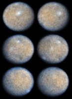
Statistically, if other cratered bodies are anything to go by, there should not be a dichotomy in terms of what portions of Ceres were hit by large impactors and what portions were not. I think one thing that is fooling us right now is that the lower half of the disk we see is at a lower sun angle, and thus shows more relief. The northern half may be nearly as heavily cratered as the southern, just washed out due to more overhead lighting in these images.
Also, a lot of the "smoother" terrain, even in the southern portion of the images, looks a little to me like basin floors, which may well end up smoothing themselves out more than ringwalls thrown up by large impacts. It's tremendously exciting to know the resolution will improve an awful lot over the next week or two! -the other Doug -------------------- The trouble ain't that there is too many fools, but that the lightning ain't distributed right. -Mark Twain
|
|
|
|
|
Feb 14 2015, 10:25 AM
Post
#3
|
|
 Member Group: Members Posts: 423 Joined: 13-November 14 From: Norway Member No.: 7310 |
QUOTE (dvandorn @ Feb 14 2015, 12:11 AM)  Statistically, if other cratered bodies are anything to go by, there should not be a dichotomy in terms of what portions of Ceres were hit by large impactors and what portions were not. I think one thing that is fooling us right now is that the lower half of the disk we see is at a lower sun angle, and thus shows more relief. The northern half may be nearly as heavily cratered as the southern, just washed out due to more overhead lighting in these images. Also, a lot of the "smoother" terrain, even in the southern portion of the images, looks a little to me like basin floors, which may well end up smoothing themselves out more than ringwalls thrown up by large impacts. I don't think either that such a dichotomy would make much sense (although e.g. Enceladus does not seem that terribly far away from having one (in terms of being cratered); and it does have one when comparing the poles specifically). But I don't see how the sun angle could explain how the apparent cratering changes with latitude and longitude both, like it does in the images. There really does appear to be some sort of transition(s) going on near the equator, indeed perhaps into basins. It might be that there are just small strips of terrain that have a slightly different topography (and that the north and south are mainly the same), but I feel confident that either the 12 Feb or 19 Feb images will vindicate my view that there is something (potentially quite trivial) going on there.  Indeed, there is just 5 days until the 221 pixel global images of 19 Februrary are taken; that date should be marked as a milestone for the exploration of the solar system. 
-------------------- |
|
|
|
 Phil Stooke Dawn approaches Ceres Jan 12 2015, 12:10 AM
 alk3997 Dawn's main antenna appears to be facing towar... Feb 12 2015, 07:35 PM algorithm QUOTE If we weren't allowed to speculate than ... Feb 12 2015, 07:44 PM fredk I think it scales with the number of pixels. So t... Feb 12 2015, 09:00 PM Gladstoner Or to paraphrase Thomas Edison, it's 1% resolu... Feb 12 2015, 10:35 PM TritonAntares QUOTE (volcanopele @ Feb 3 2015, 10:30 PM... Feb 12 2015, 10:39 PM
 volcanopele QUOTE (TritonAntares @ Feb 12 2015, 03:39... Feb 13 2015, 03:08 PM algorithm QUOTE I think it scales with the number of pixels.... Feb 12 2015, 11:44 PM Gerald While eagerly awaiting the new images, here anothe... Feb 13 2015, 02:44 AM algorimancer QUOTE (Gerald @ Feb 12 2015, 08:44 PM) ..... Feb 13 2015, 07:52 PM Bjorn Jonsson QUOTE (algorimancer @ Feb 13 2015, 07:52 ... Feb 13 2015, 08:08 PM Habukaz Resurfacing or not, you'll notice that the vis... Feb 13 2015, 08:58 PM Gerald QUOTE (algorimancer @ Feb 13 2015, 08:52 ... Feb 14 2015, 01:04 AM 0101Morpheus Those are incredible.
It is nice that we can fina... Feb 13 2015, 04:17 AM vikingmars WOW ! WOW ! WOW ! Thanks a lot Gerald ... Feb 13 2015, 09:46 AM Habukaz Dawn is talking to the DSN now. So is Voyager 1, a... Feb 13 2015, 11:59 AM belleraphon1 Looks like DAWN downlink is in progress as of 06:5... Feb 13 2015, 12:02 PM TheAnt Yes most likely on Monday, the personell on the Ma... Feb 13 2015, 04:29 PM algorimancer Exactly the point. There is a distinct line betwe... Feb 13 2015, 09:31 PM illexsquid QUOTE (dvandorn @ Feb 13 2015, 03:11 PM) ... Feb 16 2015, 05:58 AM Sherbert Fantastic work Gerald!
One has to say Ceres, ... Feb 14 2015, 12:23 AM 0101Morpheus QUOTE (Sherbert @ Feb 13 2015, 07:23 PM) ... Feb 15 2015, 04:47 AM Sherbert As a layman, a Planet, whether "Dwarf" o... Feb 15 2015, 02:07 PM jgoldader There could be phase/shadowing effects. Patience,... Feb 14 2015, 01:46 AM Paolo a new paper in open access that will probably be s... Feb 14 2015, 08:23 AM dvandorn What I guess I would have expected of a dwarf plan... Feb 15 2015, 06:23 AM JTN QUOTE (dvandorn @ Feb 15 2015, 06:23 AM) ... Feb 15 2015, 12:38 PM 0101Morpheus QUOTE (JTN @ Feb 15 2015, 07:38 AM) Ceres... Feb 15 2015, 03:09 PM Habukaz I think Ceres comes across as pretty spherical in ... Feb 15 2015, 10:55 AM nprev Pretty sure we're looking at significant compo... Feb 15 2015, 12:12 PM dvandorn Hey, guys -- as with Sherbert, I was just giving m... Feb 15 2015, 03:59 PM alk3997 QUOTE (dvandorn @ Feb 15 2015, 09:59 AM) ... Feb 15 2015, 06:04 PM Hungry4info I thought Vesta looked oddly lumpy before we got c... Feb 15 2015, 04:42 PM FOV Even poor lumpy Vesta is described as a proto-plan... Feb 15 2015, 04:49 PM Gerald Here a first, very tentative version of a map towa... Feb 15 2015, 10:05 PM Explorer1 Here's what I'm expecting: a unique body w... Feb 16 2015, 07:08 AM Steve G Am I missing something or are we not waiting for t... Feb 16 2015, 05:17 PM vikingmars QUOTE (Steve G @ Feb 16 2015, 06:17 PM) A... Feb 16 2015, 09:03 PM DrShank QUOTE (vikingmars @ Feb 16 2015, 03:03 PM... Feb 16 2015, 09:11 PM Explorer1 Yep; all waiting. Open tab on the Dawn twitter pag... Feb 16 2015, 05:25 PM Habukaz The previous release (as well as at least one more... Feb 16 2015, 05:26 PM alk3997 QUOTE (Habukaz @ Feb 16 2015, 11:26 AM) T... Feb 16 2015, 05:42 PM Habukaz QUOTE (alk3997 @ Feb 16 2015, 06:42 PM) F... Feb 16 2015, 05:48 PM jamescanvin I split the posts about airbrushed maps into a ded... Feb 17 2015, 08:40 AM vk3ukf Hello folks, it has been a while since I poked my ... Feb 17 2015, 02:14 PM Habukaz They're out.
http://www.jpl.nasa.gov/news/new... Feb 17 2015, 03:01 PM marsbug The elongated white blob in the upper centre of th... Feb 17 2015, 03:21 PM vikingmars A miniature planet : Ceres is the world of Saint-E... Feb 17 2015, 03:25 PM Superstring Definitely looks more spherical in the new images.... Feb 17 2015, 03:32 PM Bjorn Jonsson QUOTE (Superstring @ Feb 17 2015, 03:32 P... Feb 17 2015, 03:35 PM Habukaz QUOTE (Superstring @ Feb 17 2015, 04:32 P... Feb 17 2015, 03:43 PM jasedm QUOTE (Habukaz @ Feb 17 2015, 03:43 PM) i... Feb 17 2015, 03:59 PM Habukaz QUOTE (jasedm @ Feb 17 2015, 04:59 PM) No... Feb 17 2015, 04:03 PM Gerald QUOTE (Habukaz @ Feb 17 2015, 04:43 PM) I... Feb 17 2015, 11:50 PM akuo Looks less spherical to me. But not because it... Feb 17 2015, 03:41 PM Ian R I've rotated the images to a slightly more fam... Feb 17 2015, 03:50 PM fredk Here are my identifications of the previously seen... Feb 17 2015, 04:01 PM charborob I suppose a rotation movie will be posted sooner o... Feb 17 2015, 04:07 PM Habukaz QUOTE (charborob @ Feb 17 2015, 05:07 PM)... Feb 17 2015, 04:36 PM alphasam QUOTE (charborob @ Feb 17 2015, 04:07 PM)... Feb 17 2015, 04:40 PM alphasam THE white spot, the Hubble one, does not appear to... Feb 17 2015, 04:13 PM Steve G Based on the previous literature and predictions, ... Feb 17 2015, 04:14 PM Explorer1 Starting to see the Mimas resemblance more and mor... Feb 17 2015, 05:07 PM DrShank QUOTE (Explorer1 @ Feb 17 2015, 11:07 AM)... Feb 17 2015, 07:48 PM MarsInMyLifetime It is interesting how each new view raises more qu... Feb 17 2015, 08:50 PM Explorer1 The next observation is going to be more of a cres... Feb 17 2015, 09:30 PM MarkG Starting to look like a rocky mini-Callisto. Feb 17 2015, 09:37 PM antipode Gibbous or not, its looking decidedly non spherica... Feb 17 2015, 09:57 PM elakdawalla QUOTE (antipode @ Feb 17 2015, 01:57 PM) ... Feb 17 2015, 10:45 PM Ian R The latest views of Ceres, rotated and *VERY* crud... Feb 17 2015, 09:58 PM DrShank QUOTE (Ian R @ Feb 17 2015, 03:58 PM) The... Feb 17 2015, 11:47 PM dvandorn QUOTE (Ian R @ Feb 17 2015, 03:58 PM) The... Feb 18 2015, 04:07 AM elakdawalla The previously released image was clearly enlarged... Feb 17 2015, 09:59 PM fredk QUOTE (elakdawalla @ Feb 17 2015, 10:59 P... Feb 18 2015, 03:41 PM ngunn With its saturation cratering which seems to inclu... Feb 17 2015, 10:04 PM Ian R Thanks Emily! The color overlay may not be all... Feb 17 2015, 10:08 PM OWW Looks a bit like Oberon and Umbriel. Hopefully the... Feb 17 2015, 10:34 PM Sherbert The initial impression from the earlier images, th... Feb 17 2015, 11:00 PM belleraphon1 Really nice Ian....
Just looking forward to what... Feb 17 2015, 11:10 PM belleraphon1 I remember the pre-voyager days. Most folks expect... Feb 17 2015, 11:18 PM FOV At this point, the albedo differences remind me of... Feb 17 2015, 11:40 PM Gladstoner I find these mound-like features intriguing:
It... Feb 18 2015, 12:25 AM Gerald This can happen to some degree. Here I've mark... Feb 18 2015, 12:45 AM dvandorn Looking at Ian's provocatively HST-colored ima... Feb 18 2015, 04:28 AM TritonAntares QUOTE (dvandorn @ Feb 18 2015, 05:28 AM) ... Feb 18 2015, 08:39 PM TritonAntares Interesting map comparing HST albedo features and ... Feb 18 2015, 09:46 PM antipode Hmmm, looks a bit like some of the equatorial Foss... Feb 18 2015, 05:15 AM dvandorn Yeah. I can almost imagine I'm seeing a serie... Feb 18 2015, 05:24 AM Paolo the semi-circular feature in the first picture rem... Feb 18 2015, 07:58 AM elakdawalla *headdesk* Why would anybody do a thing like that?... Feb 18 2015, 03:44 PM tedstryk QUOTE (elakdawalla @ Feb 18 2015, 04:44 P... Feb 18 2015, 05:07 PM Gerald After rotating the image 50 degrees I got almost e... Feb 18 2015, 05:45 PM fredk Well, 6x1.3 = 7.8, which is close to 8. But if yo... Feb 18 2015, 06:30 PM Phil Stooke I think the dark spot with nearby apparently rayed... Feb 18 2015, 06:56 PM TritonAntares QUOTE (Phil Stooke @ Feb 18 2015, 07:56 P... Feb 18 2015, 08:04 PM belleraphon1 Wondering if the bluish areas could be from recent... Feb 18 2015, 08:06 PM Sherbert Thanks Ian for the colour overlay, really helps.
... Feb 18 2015, 10:51 PM alk3997 A couple of items from the new image release. Fir... Feb 19 2015, 05:29 AM Ian R Thanks, everyone, for your kinds comments about th... Feb 19 2015, 05:50 AM
volcanopele QUOTE (TritonAntares @ Feb 12 2015, 03:39... Feb 13 2015, 03:08 PM algorithm QUOTE I think it scales with the number of pixels.... Feb 12 2015, 11:44 PM Gerald While eagerly awaiting the new images, here anothe... Feb 13 2015, 02:44 AM algorimancer QUOTE (Gerald @ Feb 12 2015, 08:44 PM) ..... Feb 13 2015, 07:52 PM Bjorn Jonsson QUOTE (algorimancer @ Feb 13 2015, 07:52 ... Feb 13 2015, 08:08 PM Habukaz Resurfacing or not, you'll notice that the vis... Feb 13 2015, 08:58 PM Gerald QUOTE (algorimancer @ Feb 13 2015, 08:52 ... Feb 14 2015, 01:04 AM 0101Morpheus Those are incredible.
It is nice that we can fina... Feb 13 2015, 04:17 AM vikingmars WOW ! WOW ! WOW ! Thanks a lot Gerald ... Feb 13 2015, 09:46 AM Habukaz Dawn is talking to the DSN now. So is Voyager 1, a... Feb 13 2015, 11:59 AM belleraphon1 Looks like DAWN downlink is in progress as of 06:5... Feb 13 2015, 12:02 PM TheAnt Yes most likely on Monday, the personell on the Ma... Feb 13 2015, 04:29 PM algorimancer Exactly the point. There is a distinct line betwe... Feb 13 2015, 09:31 PM illexsquid QUOTE (dvandorn @ Feb 13 2015, 03:11 PM) ... Feb 16 2015, 05:58 AM Sherbert Fantastic work Gerald!
One has to say Ceres, ... Feb 14 2015, 12:23 AM 0101Morpheus QUOTE (Sherbert @ Feb 13 2015, 07:23 PM) ... Feb 15 2015, 04:47 AM Sherbert As a layman, a Planet, whether "Dwarf" o... Feb 15 2015, 02:07 PM jgoldader There could be phase/shadowing effects. Patience,... Feb 14 2015, 01:46 AM Paolo a new paper in open access that will probably be s... Feb 14 2015, 08:23 AM dvandorn What I guess I would have expected of a dwarf plan... Feb 15 2015, 06:23 AM JTN QUOTE (dvandorn @ Feb 15 2015, 06:23 AM) ... Feb 15 2015, 12:38 PM 0101Morpheus QUOTE (JTN @ Feb 15 2015, 07:38 AM) Ceres... Feb 15 2015, 03:09 PM Habukaz I think Ceres comes across as pretty spherical in ... Feb 15 2015, 10:55 AM nprev Pretty sure we're looking at significant compo... Feb 15 2015, 12:12 PM dvandorn Hey, guys -- as with Sherbert, I was just giving m... Feb 15 2015, 03:59 PM alk3997 QUOTE (dvandorn @ Feb 15 2015, 09:59 AM) ... Feb 15 2015, 06:04 PM Hungry4info I thought Vesta looked oddly lumpy before we got c... Feb 15 2015, 04:42 PM FOV Even poor lumpy Vesta is described as a proto-plan... Feb 15 2015, 04:49 PM Gerald Here a first, very tentative version of a map towa... Feb 15 2015, 10:05 PM Explorer1 Here's what I'm expecting: a unique body w... Feb 16 2015, 07:08 AM Steve G Am I missing something or are we not waiting for t... Feb 16 2015, 05:17 PM vikingmars QUOTE (Steve G @ Feb 16 2015, 06:17 PM) A... Feb 16 2015, 09:03 PM DrShank QUOTE (vikingmars @ Feb 16 2015, 03:03 PM... Feb 16 2015, 09:11 PM Explorer1 Yep; all waiting. Open tab on the Dawn twitter pag... Feb 16 2015, 05:25 PM Habukaz The previous release (as well as at least one more... Feb 16 2015, 05:26 PM alk3997 QUOTE (Habukaz @ Feb 16 2015, 11:26 AM) T... Feb 16 2015, 05:42 PM Habukaz QUOTE (alk3997 @ Feb 16 2015, 06:42 PM) F... Feb 16 2015, 05:48 PM jamescanvin I split the posts about airbrushed maps into a ded... Feb 17 2015, 08:40 AM vk3ukf Hello folks, it has been a while since I poked my ... Feb 17 2015, 02:14 PM Habukaz They're out.
http://www.jpl.nasa.gov/news/new... Feb 17 2015, 03:01 PM marsbug The elongated white blob in the upper centre of th... Feb 17 2015, 03:21 PM vikingmars A miniature planet : Ceres is the world of Saint-E... Feb 17 2015, 03:25 PM Superstring Definitely looks more spherical in the new images.... Feb 17 2015, 03:32 PM Bjorn Jonsson QUOTE (Superstring @ Feb 17 2015, 03:32 P... Feb 17 2015, 03:35 PM Habukaz QUOTE (Superstring @ Feb 17 2015, 04:32 P... Feb 17 2015, 03:43 PM jasedm QUOTE (Habukaz @ Feb 17 2015, 03:43 PM) i... Feb 17 2015, 03:59 PM Habukaz QUOTE (jasedm @ Feb 17 2015, 04:59 PM) No... Feb 17 2015, 04:03 PM Gerald QUOTE (Habukaz @ Feb 17 2015, 04:43 PM) I... Feb 17 2015, 11:50 PM akuo Looks less spherical to me. But not because it... Feb 17 2015, 03:41 PM Ian R I've rotated the images to a slightly more fam... Feb 17 2015, 03:50 PM fredk Here are my identifications of the previously seen... Feb 17 2015, 04:01 PM charborob I suppose a rotation movie will be posted sooner o... Feb 17 2015, 04:07 PM Habukaz QUOTE (charborob @ Feb 17 2015, 05:07 PM)... Feb 17 2015, 04:36 PM alphasam QUOTE (charborob @ Feb 17 2015, 04:07 PM)... Feb 17 2015, 04:40 PM alphasam THE white spot, the Hubble one, does not appear to... Feb 17 2015, 04:13 PM Steve G Based on the previous literature and predictions, ... Feb 17 2015, 04:14 PM Explorer1 Starting to see the Mimas resemblance more and mor... Feb 17 2015, 05:07 PM DrShank QUOTE (Explorer1 @ Feb 17 2015, 11:07 AM)... Feb 17 2015, 07:48 PM MarsInMyLifetime It is interesting how each new view raises more qu... Feb 17 2015, 08:50 PM Explorer1 The next observation is going to be more of a cres... Feb 17 2015, 09:30 PM MarkG Starting to look like a rocky mini-Callisto. Feb 17 2015, 09:37 PM antipode Gibbous or not, its looking decidedly non spherica... Feb 17 2015, 09:57 PM elakdawalla QUOTE (antipode @ Feb 17 2015, 01:57 PM) ... Feb 17 2015, 10:45 PM Ian R The latest views of Ceres, rotated and *VERY* crud... Feb 17 2015, 09:58 PM DrShank QUOTE (Ian R @ Feb 17 2015, 03:58 PM) The... Feb 17 2015, 11:47 PM dvandorn QUOTE (Ian R @ Feb 17 2015, 03:58 PM) The... Feb 18 2015, 04:07 AM elakdawalla The previously released image was clearly enlarged... Feb 17 2015, 09:59 PM fredk QUOTE (elakdawalla @ Feb 17 2015, 10:59 P... Feb 18 2015, 03:41 PM ngunn With its saturation cratering which seems to inclu... Feb 17 2015, 10:04 PM Ian R Thanks Emily! The color overlay may not be all... Feb 17 2015, 10:08 PM OWW Looks a bit like Oberon and Umbriel. Hopefully the... Feb 17 2015, 10:34 PM Sherbert The initial impression from the earlier images, th... Feb 17 2015, 11:00 PM belleraphon1 Really nice Ian....
Just looking forward to what... Feb 17 2015, 11:10 PM belleraphon1 I remember the pre-voyager days. Most folks expect... Feb 17 2015, 11:18 PM FOV At this point, the albedo differences remind me of... Feb 17 2015, 11:40 PM Gladstoner I find these mound-like features intriguing:
It... Feb 18 2015, 12:25 AM Gerald This can happen to some degree. Here I've mark... Feb 18 2015, 12:45 AM dvandorn Looking at Ian's provocatively HST-colored ima... Feb 18 2015, 04:28 AM TritonAntares QUOTE (dvandorn @ Feb 18 2015, 05:28 AM) ... Feb 18 2015, 08:39 PM TritonAntares Interesting map comparing HST albedo features and ... Feb 18 2015, 09:46 PM antipode Hmmm, looks a bit like some of the equatorial Foss... Feb 18 2015, 05:15 AM dvandorn Yeah. I can almost imagine I'm seeing a serie... Feb 18 2015, 05:24 AM Paolo the semi-circular feature in the first picture rem... Feb 18 2015, 07:58 AM elakdawalla *headdesk* Why would anybody do a thing like that?... Feb 18 2015, 03:44 PM tedstryk QUOTE (elakdawalla @ Feb 18 2015, 04:44 P... Feb 18 2015, 05:07 PM Gerald After rotating the image 50 degrees I got almost e... Feb 18 2015, 05:45 PM fredk Well, 6x1.3 = 7.8, which is close to 8. But if yo... Feb 18 2015, 06:30 PM Phil Stooke I think the dark spot with nearby apparently rayed... Feb 18 2015, 06:56 PM TritonAntares QUOTE (Phil Stooke @ Feb 18 2015, 07:56 P... Feb 18 2015, 08:04 PM belleraphon1 Wondering if the bluish areas could be from recent... Feb 18 2015, 08:06 PM Sherbert Thanks Ian for the colour overlay, really helps.
... Feb 18 2015, 10:51 PM alk3997 A couple of items from the new image release. Fir... Feb 19 2015, 05:29 AM Ian R Thanks, everyone, for your kinds comments about th... Feb 19 2015, 05:50 AM |

|
Lo-Fi Version | Time is now: 21st September 2024 - 10:01 AM |
|
RULES AND GUIDELINES Please read the Forum Rules and Guidelines before posting. IMAGE COPYRIGHT |
OPINIONS AND MODERATION Opinions expressed on UnmannedSpaceflight.com are those of the individual posters and do not necessarily reflect the opinions of UnmannedSpaceflight.com or The Planetary Society. The all-volunteer UnmannedSpaceflight.com moderation team is wholly independent of The Planetary Society. The Planetary Society has no influence over decisions made by the UnmannedSpaceflight.com moderators. |
SUPPORT THE FORUM Unmannedspaceflight.com is funded by the Planetary Society. Please consider supporting our work and many other projects by donating to the Society or becoming a member. |
|