Dawn approaches Ceres, From opnav images to first orbit |

Dawn approaches Ceres, From opnav images to first orbit |
 Jan 12 2015, 12:10 AM Jan 12 2015, 12:10 AM
Post
#601
|
||
|
Solar System Cartographer  Group: Members Posts: 10196 Joined: 5-April 05 From: Canada Member No.: 227 |
On Tuesday (two days from now, for visitors from the future), the first optical navigation image will be taken... hopefully we'll have it in our hands soon after that. So it's time for a new topic. Over the next few months we'll have progressively closer images and full orbit characterization sequences, no doubt including multispectral image sets.
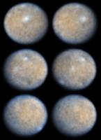
A new world... This is a bit of reprocessing I have been doing with the Hubble images from a few years ago.
Phil -------------------- ... because the Solar System ain't gonna map itself.
Also to be found posting similar content on https://mastodon.social/@PhilStooke Maps for download (free PD: https://upload.wikimedia.org/wikipedia/comm...Cartography.pdf NOTE: everything created by me which I post on UMSF is considered to be in the public domain (NOT CC, public domain) |
|
 |
 
|
|
 |
|
Mar 18 2015, 08:25 AM
Post
#602
|
|
|
Member Group: Members Posts: 107 Joined: 1-August 14 Member No.: 7227 |
Some images grouped and annotated:
 My processing of the bright-spot area of the DEM: http://lc84.altervista.org/vba4.stl It's just a quick-and-dirt 3d model, a bit more (just a bit) than a point-cloud; I'm working to get a surface instead, but what's very interesting is the altitude of the center of the crater: although I can't know the actual values of altitudes corresponding to grey levels, the relative altitudes are correct:  |
|
|
|
|
Mar 18 2015, 07:41 PM
Post
#603
|
|||
|
Junior Member Group: Members Posts: 48 Joined: 20-December 14 Member No.: 7370 |
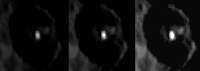
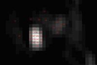
QUOTE (mcgyver @ Mar 18 2015, 12:25 AM)  My processing of the bright-spot area of the DEM: http://lc84.altervista.org/vba4.stl It's just a quick-and-dirt 3d model, a bit more (just a bit) than a point-cloud; I'm working to get a surface instead, but what's very interesting is the altitude of the center of the crater: although I can't know the actual values of altitudes corresponding to grey levels, the relative altitudes are correct: Great processing, but as others have mentioned, I think the saturated pixels in the crater obfuscate any real depth cues for the DEM algorithms. I think the the picture with the most value is the one in the rotation movie right before it goes out of view, that has the central spot unsaturated.
From that picture it could be consistent with a floor with reflective ejecta spread around (the at 5-8% of the brightest pixel value). The little white spot peak is only 25% of the brightest pixel value so it's either likely a less albedo, or more likely - much smaller (3 adjacent 1/4 pixels). For the heck of it I tested the pixels in this image to try and get a better idea of what might be going on.
% conversions relative to the brightest 242 pixel are here: 12 5% 20 8% 28 12% 44 18% 53 22% 60 25% 92 38% 100 41% 124 51% 132 55% 144 60% 163 67% 179 74% 194 80% 219 90% 227 94% 235 97% 242 100% |
||
|
|
|
||
 Phil Stooke Dawn approaches Ceres Jan 12 2015, 12:10 AM
 Astro0 For interest, I centred the white spot(s) from the... Mar 3 2015, 04:55 AM
 vikingmars QUOTE (Astro0 @ Mar 3 2015, 05:55 AM) For... Mar 3 2015, 04:23 PM John Broughton Nice bullseye pattern! If that's an old im... Mar 3 2015, 05:36 AM John Broughton The cylindrical map is inexplicably low in resolut... Mar 3 2015, 09:23 AM DrShank QUOTE (John Broughton @ Mar 2 2015, 11:36... Mar 3 2015, 01:06 PM marsbug QUOTE (John Broughton @ Mar 3 2015, 05:36... Mar 3 2015, 07:23 PM TheAnt QUOTE (marsbug @ Mar 3 2015, 08:23 PM) Wo... Mar 4 2015, 12:29 PM marsbug QUOTE (TheAnt @ Mar 4 2015, 12:29 PM) The... Mar 4 2015, 03:43 PM John Broughton QUOTE (marsbug @ Mar 3 2015, 08:23 PM) Wo... Mar 4 2015, 12:33 PM Herobrine Merged maps with Hubble color.
One small blank sp... Mar 3 2015, 06:59 AM TritonAntares Quite a few hexagonal basins and craters out there... Mar 3 2015, 11:00 AM algorimancer QUOTE (TritonAntares @ Mar 3 2015, 05:00 ... Mar 3 2015, 12:46 PM TritonAntares QUOTE (algorimancer @ Mar 3 2015, 01:46 P... Mar 3 2015, 01:12 PM Phil Stooke This is what you get if you extend Gerald's re... Mar 3 2015, 02:57 PM Phil Stooke ... and if you add those polar sections to the Daw... Mar 3 2015, 03:37 PM vikingmars QUOTE (Phil Stooke @ Mar 3 2015, 04:37 PM... Mar 3 2015, 03:59 PM Superstring Why would an ice volcano be situated right in the ... Mar 3 2015, 04:20 PM Habukaz QUOTE (Superstring @ Mar 3 2015, 05:20 PM... Mar 3 2015, 04:45 PM Bill Harris QUOTE Quite a few hexagonal basins and craters out... Mar 3 2015, 05:18 PM Gerald Merged map based on the 27 RC2 frames of pia18920.... Mar 3 2015, 05:33 PM fredk It seems with every release we find something odd ... Mar 3 2015, 06:23 PM elakdawalla QUOTE (fredk @ Mar 3 2015, 10:23 AM) Prev... Mar 3 2015, 06:42 PM Gerald The mask is probably used to mask noise/dark frame... Mar 3 2015, 06:33 PM Phil Stooke The two opnav4 images show the north pole a bit be... Mar 3 2015, 06:39 PM elakdawalla I tried to match PIA18920 animation frame 1 to PIA... Mar 3 2015, 07:04 PM fredk QUOTE (elakdawalla @ Mar 3 2015, 07:04 PM... Mar 3 2015, 07:26 PM Gerald QUOTE (fredk @ Mar 3 2015, 08:26 PM) Agre... Mar 3 2015, 08:24 PM Gerald QUOTE (fredk @ Mar 3 2015, 08:26 PM) As f... Mar 3 2015, 09:09 PM Phil Stooke Possibly a reprojection from the perspective view ... Mar 3 2015, 07:42 PM Herobrine A better combination of maps than I posted yesterd... Mar 3 2015, 07:46 PM Gladstoner Are there any released images of the longitudes ea... Mar 3 2015, 07:54 PM Gerald QUOTE (Gladstoner @ Mar 3 2015, 08:54 PM)... Mar 3 2015, 08:33 PM elakdawalla QUOTE (Phil Stooke @ Mar 3 2015, 11:42 AM... Mar 3 2015, 09:25 PM Gladstoner QUOTE (elakdawalla @ Mar 3 2015, 03:25 PM... Mar 3 2015, 10:01 PM fredk QUOTE (elakdawalla @ Mar 3 2015, 10:25 PM... Mar 3 2015, 10:46 PM Gerald QUOTE (fredk @ Mar 3 2015, 11:46 PM) I... Mar 3 2015, 11:22 PM Gerald Between two consecutive RC2 images I get a rotati... Mar 3 2015, 10:32 PM Gladstoner QUOTE (Gerald @ Mar 3 2015, 04:32 PM) Bet... Mar 3 2015, 10:46 PM Sherbert QUOTE (Gerald @ Mar 3 2015, 10:32 PM) Bet... Mar 3 2015, 11:05 PM jgoldader QUOTE (Sherbert @ Mar 3 2015, 06:05 PM) I... Mar 3 2015, 11:13 PM fredk QUOTE (jgoldader @ Mar 4 2015, 12:13 AM) ... Mar 4 2015, 03:29 PM algorimancer QUOTE (fredk @ Mar 4 2015, 09:29 AM) ... ... Mar 4 2015, 03:38 PM Phil Stooke Nice demonstration of the fact that my explanation... Mar 4 2015, 01:00 AM Gerald QUOTE (Phil Stooke @ Mar 4 2015, 02:00 AM... Mar 6 2015, 01:33 AM algorimancer I have the impression that "something" h... Mar 4 2015, 01:47 PM Sherbert QUOTE (algorimancer @ Mar 4 2015, 01:47 P... Mar 4 2015, 07:56 PM algorimancer QUOTE (Sherbert @ Mar 4 2015, 01:56 PM) .... Mar 4 2015, 08:10 PM Gerald Ceres maps normalized to about the same local sola... Mar 4 2015, 03:52 PM Gerald Great first step in analysing the light curves... Mar 4 2015, 09:20 PM Malmer QUOTE (Gerald @ Mar 4 2015, 10:20 PM) Gre... Mar 5 2015, 02:05 PM algorimancer I can estimate the albedo as the maximum value of ... Mar 5 2015, 02:29 PM Gerald QUOTE (Malmer @ Mar 5 2015, 03:05 PM) I a... Mar 5 2015, 03:10 PM Habukaz Those 'twin craters' that were very visibl... Mar 4 2015, 11:02 PM algorimancer QUOTE (Habukaz @ Mar 4 2015, 05:02 PM) Th... Mar 5 2015, 06:26 PM Habukaz QUOTE (algorimancer @ Mar 5 2015, 07:26 P... Mar 6 2015, 08:49 PM algorimancer QUOTE (Habukaz @ Mar 6 2015, 02:49 PM) ..... Mar 6 2015, 10:21 PM Gladstoner A possible process of producing straight valleys o... Mar 4 2015, 11:46 PM elakdawalla QUOTE (Gladstoner @ Mar 4 2015, 03:46 PM)... Mar 5 2015, 04:23 PM ngunn QUOTE (elakdawalla @ Mar 5 2015, 04:23 PM... Mar 5 2015, 05:22 PM Gladstoner QUOTE (ngunn @ Mar 5 2015, 11:22 AM) Pres... Mar 5 2015, 06:23 PM Gladstoner QUOTE (elakdawalla @ Mar 5 2015, 10:23 AM... Mar 5 2015, 08:53 PM TheAnt Tomorrow 6/3 Dawn will start 'officially' ... Mar 5 2015, 11:33 AM Habukaz The currently available key dates (more or less) f... Mar 5 2015, 02:53 PM 0101Morpheus I'm sure that one of the key questions for Daw... Mar 6 2015, 12:54 AM Sherbert There may not be major planetary tidal forces at p... Mar 5 2015, 10:58 PM Habukaz With the confirmation of Dawn's capture into o... Mar 6 2015, 03:22 PM elakdawalla Since Dawn's now in orbit, I made a new thread... Mar 6 2015, 04:31 PM alk3997 This is a non-enhanced zoom (800%) of the bright s... Mar 6 2015, 05:17 PM Gerald A first attempt to retrieve slope data in longitud... Mar 6 2015, 07:16 PM algorimancer QUOTE (Gerald @ Mar 6 2015, 01:16 PM) A f... Mar 6 2015, 08:36 PM Gerald QUOTE (algorimancer @ Mar 6 2015, 09:36 P... Mar 6 2015, 11:16 PM Habukaz Not sure which Saturnian moons and which features ... Mar 6 2015, 11:15 PM Gladstoner Recent images at 200%:
PIA19311:
PIA19312:
... Mar 6 2015, 11:39 PM Sherbert One thing these crescent views show is how flat bo... Mar 8 2015, 01:04 AM Gladstoner It appears the released crescent images were verti... Mar 8 2015, 11:59 PM Gladstoner PIA19310b_lg at 200% with unaltered pixels:
A... Mar 10 2015, 08:15 AM mcgyver This thread can be closed in favour of thread abo... Mar 12 2015, 01:00 PM JohnVV PDS has a shape file
ftp://naif.jpl.nasa.gov/pub/... Mar 15 2015, 07:23 AM algorimancer For anyone comfortable with R, here is some R code... Mar 16 2015, 03:38 PM Phil Stooke A nice new thing at LPSC - a map of Ceres in false... Mar 16 2015, 09:00 PM Jackbauer From the 46th Lunar and Planetary Science Conferen... Mar 17 2015, 09:06 AM Habukaz The Sander crater on Mercury contains very bright ... Mar 17 2015, 11:13 AM Habukaz Some interesting yet confusing tweets from the LPS... Mar 17 2015, 02:38 PM jgoldader QUOTE (Habukaz @ Mar 17 2015, 09:38 AM) S... Mar 17 2015, 03:10 PM TheAnt QUOTE (Habukaz @ Mar 17 2015, 03:38 PM) S... Mar 17 2015, 03:28 PM Ken2 QUOTE (Habukaz @ Mar 17 2015, 06:38 AM) S... Mar 17 2015, 06:13 PM ngunn Monica Grady refers to a feature seen on the limb ... Mar 17 2015, 06:40 PM Gladstoner QUOTE (ngunn @ Mar 17 2015, 01:40 PM) Mon... Mar 17 2015, 07:13 PM belleraphon1 A bit more detail on what was presented at LPSC re... Mar 17 2015, 10:41 PM vikingmars QUOTE (mcgyver @ Mar 18 2015, 09:25 AM) S... Mar 18 2015, 08:52 AM TheAnt QUOTE (Ken2 @ Mar 18 2015, 08:41 PM) From... Mar 19 2015, 12:31 PM algorimancer QUOTE (mcgyver @ Mar 18 2015, 03:25 AM) S... Mar 19 2015, 07:00 PM 4throck Based on the maps posted previously, here's co... Mar 18 2015, 11:18 PM algorimancer QUOTE (4throck @ Mar 18 2015, 06:18 PM) B... Mar 19 2015, 01:33 PM mcgyver Just found this interesting Ceres images resources... Mar 19 2015, 10:28 AM Gladstoner Has anyone estimated the minimum albedo of the mos... Mar 19 2015, 05:57 PM algorimancer And here's the same height map, with the heigh... Mar 19 2015, 09:24 PM
vikingmars QUOTE (Astro0 @ Mar 3 2015, 05:55 AM) For... Mar 3 2015, 04:23 PM John Broughton Nice bullseye pattern! If that's an old im... Mar 3 2015, 05:36 AM John Broughton The cylindrical map is inexplicably low in resolut... Mar 3 2015, 09:23 AM DrShank QUOTE (John Broughton @ Mar 2 2015, 11:36... Mar 3 2015, 01:06 PM marsbug QUOTE (John Broughton @ Mar 3 2015, 05:36... Mar 3 2015, 07:23 PM TheAnt QUOTE (marsbug @ Mar 3 2015, 08:23 PM) Wo... Mar 4 2015, 12:29 PM marsbug QUOTE (TheAnt @ Mar 4 2015, 12:29 PM) The... Mar 4 2015, 03:43 PM John Broughton QUOTE (marsbug @ Mar 3 2015, 08:23 PM) Wo... Mar 4 2015, 12:33 PM Herobrine Merged maps with Hubble color.
One small blank sp... Mar 3 2015, 06:59 AM TritonAntares Quite a few hexagonal basins and craters out there... Mar 3 2015, 11:00 AM algorimancer QUOTE (TritonAntares @ Mar 3 2015, 05:00 ... Mar 3 2015, 12:46 PM TritonAntares QUOTE (algorimancer @ Mar 3 2015, 01:46 P... Mar 3 2015, 01:12 PM Phil Stooke This is what you get if you extend Gerald's re... Mar 3 2015, 02:57 PM Phil Stooke ... and if you add those polar sections to the Daw... Mar 3 2015, 03:37 PM vikingmars QUOTE (Phil Stooke @ Mar 3 2015, 04:37 PM... Mar 3 2015, 03:59 PM Superstring Why would an ice volcano be situated right in the ... Mar 3 2015, 04:20 PM Habukaz QUOTE (Superstring @ Mar 3 2015, 05:20 PM... Mar 3 2015, 04:45 PM Bill Harris QUOTE Quite a few hexagonal basins and craters out... Mar 3 2015, 05:18 PM Gerald Merged map based on the 27 RC2 frames of pia18920.... Mar 3 2015, 05:33 PM fredk It seems with every release we find something odd ... Mar 3 2015, 06:23 PM elakdawalla QUOTE (fredk @ Mar 3 2015, 10:23 AM) Prev... Mar 3 2015, 06:42 PM Gerald The mask is probably used to mask noise/dark frame... Mar 3 2015, 06:33 PM Phil Stooke The two opnav4 images show the north pole a bit be... Mar 3 2015, 06:39 PM elakdawalla I tried to match PIA18920 animation frame 1 to PIA... Mar 3 2015, 07:04 PM fredk QUOTE (elakdawalla @ Mar 3 2015, 07:04 PM... Mar 3 2015, 07:26 PM Gerald QUOTE (fredk @ Mar 3 2015, 08:26 PM) Agre... Mar 3 2015, 08:24 PM Gerald QUOTE (fredk @ Mar 3 2015, 08:26 PM) As f... Mar 3 2015, 09:09 PM Phil Stooke Possibly a reprojection from the perspective view ... Mar 3 2015, 07:42 PM Herobrine A better combination of maps than I posted yesterd... Mar 3 2015, 07:46 PM Gladstoner Are there any released images of the longitudes ea... Mar 3 2015, 07:54 PM Gerald QUOTE (Gladstoner @ Mar 3 2015, 08:54 PM)... Mar 3 2015, 08:33 PM elakdawalla QUOTE (Phil Stooke @ Mar 3 2015, 11:42 AM... Mar 3 2015, 09:25 PM Gladstoner QUOTE (elakdawalla @ Mar 3 2015, 03:25 PM... Mar 3 2015, 10:01 PM fredk QUOTE (elakdawalla @ Mar 3 2015, 10:25 PM... Mar 3 2015, 10:46 PM Gerald QUOTE (fredk @ Mar 3 2015, 11:46 PM) I... Mar 3 2015, 11:22 PM Gerald Between two consecutive RC2 images I get a rotati... Mar 3 2015, 10:32 PM Gladstoner QUOTE (Gerald @ Mar 3 2015, 04:32 PM) Bet... Mar 3 2015, 10:46 PM Sherbert QUOTE (Gerald @ Mar 3 2015, 10:32 PM) Bet... Mar 3 2015, 11:05 PM jgoldader QUOTE (Sherbert @ Mar 3 2015, 06:05 PM) I... Mar 3 2015, 11:13 PM fredk QUOTE (jgoldader @ Mar 4 2015, 12:13 AM) ... Mar 4 2015, 03:29 PM algorimancer QUOTE (fredk @ Mar 4 2015, 09:29 AM) ... ... Mar 4 2015, 03:38 PM Phil Stooke Nice demonstration of the fact that my explanation... Mar 4 2015, 01:00 AM Gerald QUOTE (Phil Stooke @ Mar 4 2015, 02:00 AM... Mar 6 2015, 01:33 AM algorimancer I have the impression that "something" h... Mar 4 2015, 01:47 PM Sherbert QUOTE (algorimancer @ Mar 4 2015, 01:47 P... Mar 4 2015, 07:56 PM algorimancer QUOTE (Sherbert @ Mar 4 2015, 01:56 PM) .... Mar 4 2015, 08:10 PM Gerald Ceres maps normalized to about the same local sola... Mar 4 2015, 03:52 PM Gerald Great first step in analysing the light curves... Mar 4 2015, 09:20 PM Malmer QUOTE (Gerald @ Mar 4 2015, 10:20 PM) Gre... Mar 5 2015, 02:05 PM algorimancer I can estimate the albedo as the maximum value of ... Mar 5 2015, 02:29 PM Gerald QUOTE (Malmer @ Mar 5 2015, 03:05 PM) I a... Mar 5 2015, 03:10 PM Habukaz Those 'twin craters' that were very visibl... Mar 4 2015, 11:02 PM algorimancer QUOTE (Habukaz @ Mar 4 2015, 05:02 PM) Th... Mar 5 2015, 06:26 PM Habukaz QUOTE (algorimancer @ Mar 5 2015, 07:26 P... Mar 6 2015, 08:49 PM algorimancer QUOTE (Habukaz @ Mar 6 2015, 02:49 PM) ..... Mar 6 2015, 10:21 PM Gladstoner A possible process of producing straight valleys o... Mar 4 2015, 11:46 PM elakdawalla QUOTE (Gladstoner @ Mar 4 2015, 03:46 PM)... Mar 5 2015, 04:23 PM ngunn QUOTE (elakdawalla @ Mar 5 2015, 04:23 PM... Mar 5 2015, 05:22 PM Gladstoner QUOTE (ngunn @ Mar 5 2015, 11:22 AM) Pres... Mar 5 2015, 06:23 PM Gladstoner QUOTE (elakdawalla @ Mar 5 2015, 10:23 AM... Mar 5 2015, 08:53 PM TheAnt Tomorrow 6/3 Dawn will start 'officially' ... Mar 5 2015, 11:33 AM Habukaz The currently available key dates (more or less) f... Mar 5 2015, 02:53 PM 0101Morpheus I'm sure that one of the key questions for Daw... Mar 6 2015, 12:54 AM Sherbert There may not be major planetary tidal forces at p... Mar 5 2015, 10:58 PM Habukaz With the confirmation of Dawn's capture into o... Mar 6 2015, 03:22 PM elakdawalla Since Dawn's now in orbit, I made a new thread... Mar 6 2015, 04:31 PM alk3997 This is a non-enhanced zoom (800%) of the bright s... Mar 6 2015, 05:17 PM Gerald A first attempt to retrieve slope data in longitud... Mar 6 2015, 07:16 PM algorimancer QUOTE (Gerald @ Mar 6 2015, 01:16 PM) A f... Mar 6 2015, 08:36 PM Gerald QUOTE (algorimancer @ Mar 6 2015, 09:36 P... Mar 6 2015, 11:16 PM Habukaz Not sure which Saturnian moons and which features ... Mar 6 2015, 11:15 PM Gladstoner Recent images at 200%:
PIA19311:
PIA19312:
... Mar 6 2015, 11:39 PM Sherbert One thing these crescent views show is how flat bo... Mar 8 2015, 01:04 AM Gladstoner It appears the released crescent images were verti... Mar 8 2015, 11:59 PM Gladstoner PIA19310b_lg at 200% with unaltered pixels:
A... Mar 10 2015, 08:15 AM mcgyver This thread can be closed in favour of thread abo... Mar 12 2015, 01:00 PM JohnVV PDS has a shape file
ftp://naif.jpl.nasa.gov/pub/... Mar 15 2015, 07:23 AM algorimancer For anyone comfortable with R, here is some R code... Mar 16 2015, 03:38 PM Phil Stooke A nice new thing at LPSC - a map of Ceres in false... Mar 16 2015, 09:00 PM Jackbauer From the 46th Lunar and Planetary Science Conferen... Mar 17 2015, 09:06 AM Habukaz The Sander crater on Mercury contains very bright ... Mar 17 2015, 11:13 AM Habukaz Some interesting yet confusing tweets from the LPS... Mar 17 2015, 02:38 PM jgoldader QUOTE (Habukaz @ Mar 17 2015, 09:38 AM) S... Mar 17 2015, 03:10 PM TheAnt QUOTE (Habukaz @ Mar 17 2015, 03:38 PM) S... Mar 17 2015, 03:28 PM Ken2 QUOTE (Habukaz @ Mar 17 2015, 06:38 AM) S... Mar 17 2015, 06:13 PM ngunn Monica Grady refers to a feature seen on the limb ... Mar 17 2015, 06:40 PM Gladstoner QUOTE (ngunn @ Mar 17 2015, 01:40 PM) Mon... Mar 17 2015, 07:13 PM belleraphon1 A bit more detail on what was presented at LPSC re... Mar 17 2015, 10:41 PM vikingmars QUOTE (mcgyver @ Mar 18 2015, 09:25 AM) S... Mar 18 2015, 08:52 AM TheAnt QUOTE (Ken2 @ Mar 18 2015, 08:41 PM) From... Mar 19 2015, 12:31 PM algorimancer QUOTE (mcgyver @ Mar 18 2015, 03:25 AM) S... Mar 19 2015, 07:00 PM 4throck Based on the maps posted previously, here's co... Mar 18 2015, 11:18 PM algorimancer QUOTE (4throck @ Mar 18 2015, 06:18 PM) B... Mar 19 2015, 01:33 PM mcgyver Just found this interesting Ceres images resources... Mar 19 2015, 10:28 AM Gladstoner Has anyone estimated the minimum albedo of the mos... Mar 19 2015, 05:57 PM algorimancer And here's the same height map, with the heigh... Mar 19 2015, 09:24 PM |

|
Lo-Fi Version | Time is now: 23rd June 2024 - 04:17 AM |
|
RULES AND GUIDELINES Please read the Forum Rules and Guidelines before posting. IMAGE COPYRIGHT |
OPINIONS AND MODERATION Opinions expressed on UnmannedSpaceflight.com are those of the individual posters and do not necessarily reflect the opinions of UnmannedSpaceflight.com or The Planetary Society. The all-volunteer UnmannedSpaceflight.com moderation team is wholly independent of The Planetary Society. The Planetary Society has no influence over decisions made by the UnmannedSpaceflight.com moderators. |
SUPPORT THE FORUM Unmannedspaceflight.com is funded by the Planetary Society. Please consider supporting our work and many other projects by donating to the Society or becoming a member. |
|