Pluto Surface Observations 1: NH Post-Encounter Phase, 1 Aug 2015- 10 Oct 2015 |

Pluto Surface Observations 1: NH Post-Encounter Phase, 1 Aug 2015- 10 Oct 2015 |
 Aug 1 2015, 05:53 PM Aug 1 2015, 05:53 PM
Post
#1
|
|
|
Merciless Robot  Group: Admin Posts: 8785 Joined: 8-December 05 From: Los Angeles Member No.: 602 |
This topic will contain images & discussion of same as they arrive during the extended download period. Similar threads will be opened in coming months as required as acquired data & discussion proceeds.
-------------------- A few will take this knowledge and use this power of a dream realized as a force for change, an impetus for further discovery to make less ancient dreams real.
|
 |
 
|
 |
|
Aug 10 2015, 07:00 PM
Post
#2
|
|||
 Junior Member Group: Members Posts: 82 Joined: 13-July 15 Member No.: 7579 |
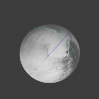
With the use of metadata of LORRI frames I clarify trajectory of New Horizons (error is about 0.000002 on distancies to Pluto at snapshots momens). After that it made possible to simulate all frames with subpixel accuracy. Here for example, two of these frames:
As a bonus Pluto radius was determined: R=240.89 km * u, where 'u' is LORRI pixel size in microradians. If we assume that the under-Charon avarage point has longitude 0°, then the map of Pluto (for example http://www.unmannedspaceflight.com/index.p...t&id=37374) is offset by 1.6 ° to the east. So I had to make such correction to map, that the image consistent with LORRI frames. Nevertheless, clear to see that there are still quite a strong distortion in the map. |
||
|
|
|
||
|
Aug 10 2015, 07:25 PM
Post
#3
|
|
 IMG to PNG GOD Group: Moderator Posts: 2254 Joined: 19-February 04 From: Near fire and ice Member No.: 38 |
QUOTE (Gennady Ionov @ Aug 10 2015, 07:00 PM)  With the use of metadata of LORRI frames I clarify trajectory of New Horizons (error is about 0.000002 on the current distance to Pluto). After that it made possible to simulate all frames with subpixel accuracy. Here for example, one of these frames: As a bonus Pluto radius was determined: R=240.89 km * u, where 'u' is LORRI pixel size in microradians. This translates to 1193.6 km, consistent with the 1185 +/- km measured by the NH team a day before the flyby (interestingly, I got a value of 1194 km km back then). Regarding NH's trajectory, if I remember correctly the flyby didn't occur at exactly the planned time (off by some seconds but well within the required accuracy) and this makes it more tricky to use the metadata to accurately determine the viewing geometry (especially in the hi-res images) until an updated trajectory (SPICE kernels) becomes avvailable. |
|
|
|
 nprev Pluto Surface Observations 1: NH Post-Encounter Phase Aug 1 2015, 05:53 PM
 Gennady Ionov User torque_xtr (http://www.astronomy.ru/forum/ind... Aug 2 2015, 07:54 AM Gennady Ionov Excuse me, is there somewhere information about ex... Aug 2 2015, 05:58 PM scalbers There are images (yet to be downlinked) of Pluto l... Aug 2 2015, 06:19 PM
 JRehling I expect Pluto's axis of rotation to be very s... Aug 3 2015, 06:44 PM
 Gennady Ionov QUOTE (scalbers @ Aug 2 2015, 11:19 PM) T... Aug 4 2015, 05:27 PM Gerald QUOTE (Gennady Ionov @ Aug 4 2015, 07:27 ... Aug 4 2015, 07:26 PM Gennady Ionov Color pictures give density of irradiated solar en... Aug 3 2015, 08:24 AM Habukaz In Pluto's north, there are these dark smudges... Aug 3 2015, 10:14 AM Bill Harris QUOTE Interesting to note minimum insolation at th... Aug 3 2015, 02:11 PM scalbers QUOTE (Bill Harris @ Aug 3 2015, 02:11 PM... Aug 3 2015, 04:34 PM Gennady Ionov Another interesting feature of relief: small dimpl... Aug 3 2015, 02:30 PM Bill Harris QUOTE an additional assumption of a circular orbit... Aug 3 2015, 07:48 PM ngunn I don't think the surface is decoupled from th... Aug 4 2015, 12:13 AM Bill Harris There is no evidence either way, but I don't t... Aug 4 2015, 01:00 AM lollipop "Plutos insolation history: Latitudinal vari... Aug 4 2015, 10:02 AM Bill Harris Yes! I'm planning to read that once I ge... Aug 4 2015, 01:36 PM alan I read somewhere that the Charonshine images of Pl... Aug 4 2015, 05:49 PM JRehling Checking the orbital positions, there were Charons... Aug 4 2015, 06:04 PM Gennady Ionov Alan, Gerald, thank you very much for this encoura... Aug 4 2015, 08:04 PM alan I believe these are the MVIC and LORRI Charonshine... Aug 6 2015, 09:06 PM JRehling According to Solar System Simulator, Charon was at... Aug 6 2015, 10:11 PM Bjorn Jonsson QUOTE (alan @ Aug 6 2015, 09:06 PM) I bel... Aug 7 2015, 11:41 PM alan So roughly half of Pluto in Charonshine then. Aug 7 2015, 06:47 PM JRehling QUOTE (alan @ Aug 7 2015, 11:47 AM) So ro... Aug 7 2015, 07:55 PM scalbers A key part of this point is that half of the night... Aug 7 2015, 08:17 PM Phil Stooke Another point to consider: since the illumination ... Aug 7 2015, 08:42 PM Bill Harris QUOTE half of the night side of Pluto will be illu... Aug 7 2015, 08:56 PM ngunn All the posters here clearly understand the geomet... Aug 7 2015, 09:44 PM Explorer1 One could take a map like the ones we already have... Aug 7 2015, 10:04 PM scalbers Yes the approximate region on the Pluto maps would... Aug 7 2015, 10:22 PM Gennady Ionov With the use of map
http://www.unmannedspaceflight... Aug 8 2015, 09:29 AM Bjorn Jonsson I have been experimenting with generating DEMs of ... Aug 8 2015, 12:17 PM HSchirmer QUOTE (Bjorn Jonsson @ Aug 8 2015, 12:17 ... Aug 8 2015, 07:04 PM Phil Stooke The dark swirls may be due to grain size changes, ... Aug 8 2015, 07:19 PM nprev Agreed, Phil. These wide-view images don't pro... Aug 8 2015, 08:11 PM Bjorn Jonsson Speaking of ices, glaciers, flow patterns etc., a ... Aug 8 2015, 09:20 PM ngunn I'm not yet convinced there is flowing ice her... Aug 8 2015, 09:25 PM Bjorn Jonsson I'm not either - as I mentioned above, the res... Aug 8 2015, 09:32 PM HSchirmer QUOTE (Bjorn Jonsson @ Aug 8 2015, 10:32 ... Aug 9 2015, 04:32 PM Nafnlaus QUOTE If liquid phases of N2 are stable a few mete... Aug 10 2015, 11:38 AM HSchirmer QUOTE (Nafnlaus @ Aug 10 2015, 12:38 PM) ... Aug 10 2015, 02:38 PM Sherbert QUOTE (HSchirmer @ Aug 10 2015, 03:38 PM)... Aug 13 2015, 03:30 PM HSchirmer QUOTE (Sherbert @ Aug 13 2015, 03:30 PM) ... Aug 14 2015, 04:41 PM Sherbert The video below shows liquid Nitrogen freezes init... Aug 15 2015, 02:08 PM Tom Dahl Fascinating video, thank you for sharing it. Aug 16 2015, 12:00 PM Sherbert Since the older surface and the "glaciers... Aug 10 2015, 01:38 PM Gennady Ionov QUOTE (Bjorn Jonsson @ Aug 11 2015, 12:25... Aug 10 2015, 08:06 PM MichaelJWP Hi all, I rarely post, but had a question on this ... Aug 12 2015, 11:40 AM Gennady Ionov Michael, I, too, for a long time the question aros... Aug 12 2015, 12:38 PM nprev Imaging this was suggested several years ago, but ... Aug 12 2015, 04:26 PM scalbers QUOTE (nprev @ Aug 12 2015, 04:26 PM) Ima... Aug 12 2015, 05:11 PM Gennady Ionov What kind of scientific data loss can be a questio... Aug 12 2015, 04:47 PM MichaelJWP QUOTE (Gennady Ionov @ Aug 12 2015, 05:47... Aug 12 2015, 05:00 PM Bjorn Jonsson QUOTE (MichaelJWP @ Aug 12 2015, 05:00 PM... Aug 12 2015, 05:40 PM Gennady Ionov QUOTE (Bjorn Jonsson @ Aug 12 2015, 10:40... Aug 12 2015, 05:57 PM djellison QUOTE (Gennady Ionov @ Aug 12 2015, 09:47... Aug 12 2015, 05:56 PM elakdawalla AFAIK shooting these images was briefly considered... Aug 12 2015, 08:11 PM Gennady Ionov QUOTE (elakdawalla @ Aug 13 2015, 01:11 A... Aug 13 2015, 03:07 AM nprev Lacking any direct knowledge, I cannot say for cer... Aug 13 2015, 03:53 AM Explorer1 We could always simulate the view at any rate, rig... Aug 13 2015, 04:41 AM MichaelJWP QUOTE (Explorer1 @ Aug 13 2015, 05:41 AM)... Aug 13 2015, 08:58 AM Gsnorgathon QUOTE (Explorer1 @ Aug 12 2015, 09:41 PM)... Aug 13 2015, 07:51 PM Habukaz Not sure if this has been brought up already, but ... Aug 16 2015, 01:25 PM HSchirmer QUOTE (Habukaz @ Aug 16 2015, 02:25 PM) .... Aug 21 2015, 07:18 PM Bill Harris It seems that the "Southern Outcrops" o... Aug 16 2015, 03:44 PM HSchirmer QUOTE (Bill Harris @ Aug 16 2015, 03:44 P... Aug 16 2015, 04:32 PM HSchirmer Here's the link to the article on Pluto and se... Aug 16 2015, 04:41 PM ngunn QUOTE (HSchirmer @ Aug 16 2015, 05:41 PM)... Aug 17 2015, 09:03 PM alan From the activity timeline:
QUOTE New Horizons is ... Aug 16 2015, 09:31 PM Bill Harris I don't know. REX is a passive device assoc w... Aug 17 2015, 07:19 PM stevesliva IIRC, REX can be active, so the receiver may be on... Aug 17 2015, 07:37 PM Gennady Ionov It calculates a series of animations about the New... Aug 20 2015, 05:24 AM Bjorn Jonsson QUOTE (Gennady Ionov @ Aug 20 2015, 05:24... Aug 20 2015, 10:42 PM Gennady Ionov QUOTE (Bjorn Jonsson @ Aug 21 2015, 03:42... Aug 21 2015, 06:38 AM Ian R Gennady, those movies are AMAZING! Utterly bre... Aug 20 2015, 09:26 AM Gennady Ionov QUOTE (Ian R @ Aug 20 2015, 02:26 PM) Gen... Aug 20 2015, 11:36 AM Habukaz I was intrigued by what appears to be 'cells... Aug 20 2015, 03:23 PM Gennady Ionov QUOTE (Habukaz @ Aug 20 2015, 08:23 PM) I... Aug 20 2015, 03:57 PM Habukaz QUOTE (Gennady Ionov @ Aug 20 2015, 05:57... Aug 21 2015, 08:22 AM Gennady Ionov QUOTE (Habukaz @ Aug 21 2015, 01:22 PM) T... Aug 21 2015, 12:50 PM Habukaz The idea was not that the dark particles were crea... Aug 21 2015, 01:56 PM JRehling My sense is that the production of this terrain wa... Aug 21 2015, 04:52 PM TheAnt QUOTE (JRehling @ Aug 21 2015, 06:52 PM) ... Aug 21 2015, 05:05 PM Habukaz QUOTE (JRehling @ Aug 21 2015, 06:52 PM) ... Aug 22 2015, 05:35 PM JRehling QUOTE (Habukaz @ Aug 22 2015, 10:35 AM) I... Aug 23 2015, 01:17 PM Habukaz QUOTE (JRehling @ Aug 23 2015, 03:17 PM) ... Aug 23 2015, 02:27 PM JRehling QUOTE (Habukaz @ Aug 23 2015, 07:27 AM) I... Aug 24 2015, 12:04 PM HSchirmer QUOTE (JRehling @ Aug 24 2015, 01:04 PM) ... Aug 24 2015, 01:32 PM Gennady Ionov So if the Pluto mountains consist of water ice, we... Aug 21 2015, 04:25 PM Gladstoner The bubble-like 'cells' in north Sputnik:
... Aug 24 2015, 07:43 AM Nafnlaus It's common for glaciers to have some sort of ... Aug 24 2015, 10:28 AM Nafnlaus Another case where it's so unfortunate that NH... Aug 25 2015, 03:26 PM HSchirmer QUOTE (Nafnlaus @ Aug 25 2015, 03:26 PM) ... Aug 25 2015, 05:42 PM siravan QUOTE (Nafnlaus @ Aug 25 2015, 10:26 AM) ... Aug 25 2015, 06:50 PM HSchirmer QUOTE (siravan @ Aug 25 2015, 06:50 PM) N... Aug 25 2015, 08:19 PM Habukaz Next image from NH might arrive Saturday next week... Aug 25 2015, 05:50 PM
Gennady Ionov QUOTE (scalbers @ Aug 2 2015, 11:19 PM) T... Aug 4 2015, 05:27 PM Gerald QUOTE (Gennady Ionov @ Aug 4 2015, 07:27 ... Aug 4 2015, 07:26 PM Gennady Ionov Color pictures give density of irradiated solar en... Aug 3 2015, 08:24 AM Habukaz In Pluto's north, there are these dark smudges... Aug 3 2015, 10:14 AM Bill Harris QUOTE Interesting to note minimum insolation at th... Aug 3 2015, 02:11 PM scalbers QUOTE (Bill Harris @ Aug 3 2015, 02:11 PM... Aug 3 2015, 04:34 PM Gennady Ionov Another interesting feature of relief: small dimpl... Aug 3 2015, 02:30 PM Bill Harris QUOTE an additional assumption of a circular orbit... Aug 3 2015, 07:48 PM ngunn I don't think the surface is decoupled from th... Aug 4 2015, 12:13 AM Bill Harris There is no evidence either way, but I don't t... Aug 4 2015, 01:00 AM lollipop "Plutos insolation history: Latitudinal vari... Aug 4 2015, 10:02 AM Bill Harris Yes! I'm planning to read that once I ge... Aug 4 2015, 01:36 PM alan I read somewhere that the Charonshine images of Pl... Aug 4 2015, 05:49 PM JRehling Checking the orbital positions, there were Charons... Aug 4 2015, 06:04 PM Gennady Ionov Alan, Gerald, thank you very much for this encoura... Aug 4 2015, 08:04 PM alan I believe these are the MVIC and LORRI Charonshine... Aug 6 2015, 09:06 PM JRehling According to Solar System Simulator, Charon was at... Aug 6 2015, 10:11 PM Bjorn Jonsson QUOTE (alan @ Aug 6 2015, 09:06 PM) I bel... Aug 7 2015, 11:41 PM alan So roughly half of Pluto in Charonshine then. Aug 7 2015, 06:47 PM JRehling QUOTE (alan @ Aug 7 2015, 11:47 AM) So ro... Aug 7 2015, 07:55 PM scalbers A key part of this point is that half of the night... Aug 7 2015, 08:17 PM Phil Stooke Another point to consider: since the illumination ... Aug 7 2015, 08:42 PM Bill Harris QUOTE half of the night side of Pluto will be illu... Aug 7 2015, 08:56 PM ngunn All the posters here clearly understand the geomet... Aug 7 2015, 09:44 PM Explorer1 One could take a map like the ones we already have... Aug 7 2015, 10:04 PM scalbers Yes the approximate region on the Pluto maps would... Aug 7 2015, 10:22 PM Gennady Ionov With the use of map
http://www.unmannedspaceflight... Aug 8 2015, 09:29 AM Bjorn Jonsson I have been experimenting with generating DEMs of ... Aug 8 2015, 12:17 PM HSchirmer QUOTE (Bjorn Jonsson @ Aug 8 2015, 12:17 ... Aug 8 2015, 07:04 PM Phil Stooke The dark swirls may be due to grain size changes, ... Aug 8 2015, 07:19 PM nprev Agreed, Phil. These wide-view images don't pro... Aug 8 2015, 08:11 PM Bjorn Jonsson Speaking of ices, glaciers, flow patterns etc., a ... Aug 8 2015, 09:20 PM ngunn I'm not yet convinced there is flowing ice her... Aug 8 2015, 09:25 PM Bjorn Jonsson I'm not either - as I mentioned above, the res... Aug 8 2015, 09:32 PM HSchirmer QUOTE (Bjorn Jonsson @ Aug 8 2015, 10:32 ... Aug 9 2015, 04:32 PM Nafnlaus QUOTE If liquid phases of N2 are stable a few mete... Aug 10 2015, 11:38 AM HSchirmer QUOTE (Nafnlaus @ Aug 10 2015, 12:38 PM) ... Aug 10 2015, 02:38 PM Sherbert QUOTE (HSchirmer @ Aug 10 2015, 03:38 PM)... Aug 13 2015, 03:30 PM HSchirmer QUOTE (Sherbert @ Aug 13 2015, 03:30 PM) ... Aug 14 2015, 04:41 PM Sherbert The video below shows liquid Nitrogen freezes init... Aug 15 2015, 02:08 PM Tom Dahl Fascinating video, thank you for sharing it. Aug 16 2015, 12:00 PM Sherbert Since the older surface and the "glaciers... Aug 10 2015, 01:38 PM Gennady Ionov QUOTE (Bjorn Jonsson @ Aug 11 2015, 12:25... Aug 10 2015, 08:06 PM MichaelJWP Hi all, I rarely post, but had a question on this ... Aug 12 2015, 11:40 AM Gennady Ionov Michael, I, too, for a long time the question aros... Aug 12 2015, 12:38 PM nprev Imaging this was suggested several years ago, but ... Aug 12 2015, 04:26 PM scalbers QUOTE (nprev @ Aug 12 2015, 04:26 PM) Ima... Aug 12 2015, 05:11 PM Gennady Ionov What kind of scientific data loss can be a questio... Aug 12 2015, 04:47 PM MichaelJWP QUOTE (Gennady Ionov @ Aug 12 2015, 05:47... Aug 12 2015, 05:00 PM Bjorn Jonsson QUOTE (MichaelJWP @ Aug 12 2015, 05:00 PM... Aug 12 2015, 05:40 PM Gennady Ionov QUOTE (Bjorn Jonsson @ Aug 12 2015, 10:40... Aug 12 2015, 05:57 PM djellison QUOTE (Gennady Ionov @ Aug 12 2015, 09:47... Aug 12 2015, 05:56 PM elakdawalla AFAIK shooting these images was briefly considered... Aug 12 2015, 08:11 PM Gennady Ionov QUOTE (elakdawalla @ Aug 13 2015, 01:11 A... Aug 13 2015, 03:07 AM nprev Lacking any direct knowledge, I cannot say for cer... Aug 13 2015, 03:53 AM Explorer1 We could always simulate the view at any rate, rig... Aug 13 2015, 04:41 AM MichaelJWP QUOTE (Explorer1 @ Aug 13 2015, 05:41 AM)... Aug 13 2015, 08:58 AM Gsnorgathon QUOTE (Explorer1 @ Aug 12 2015, 09:41 PM)... Aug 13 2015, 07:51 PM Habukaz Not sure if this has been brought up already, but ... Aug 16 2015, 01:25 PM HSchirmer QUOTE (Habukaz @ Aug 16 2015, 02:25 PM) .... Aug 21 2015, 07:18 PM Bill Harris It seems that the "Southern Outcrops" o... Aug 16 2015, 03:44 PM HSchirmer QUOTE (Bill Harris @ Aug 16 2015, 03:44 P... Aug 16 2015, 04:32 PM HSchirmer Here's the link to the article on Pluto and se... Aug 16 2015, 04:41 PM ngunn QUOTE (HSchirmer @ Aug 16 2015, 05:41 PM)... Aug 17 2015, 09:03 PM alan From the activity timeline:
QUOTE New Horizons is ... Aug 16 2015, 09:31 PM Bill Harris I don't know. REX is a passive device assoc w... Aug 17 2015, 07:19 PM stevesliva IIRC, REX can be active, so the receiver may be on... Aug 17 2015, 07:37 PM Gennady Ionov It calculates a series of animations about the New... Aug 20 2015, 05:24 AM Bjorn Jonsson QUOTE (Gennady Ionov @ Aug 20 2015, 05:24... Aug 20 2015, 10:42 PM Gennady Ionov QUOTE (Bjorn Jonsson @ Aug 21 2015, 03:42... Aug 21 2015, 06:38 AM Ian R Gennady, those movies are AMAZING! Utterly bre... Aug 20 2015, 09:26 AM Gennady Ionov QUOTE (Ian R @ Aug 20 2015, 02:26 PM) Gen... Aug 20 2015, 11:36 AM Habukaz I was intrigued by what appears to be 'cells... Aug 20 2015, 03:23 PM Gennady Ionov QUOTE (Habukaz @ Aug 20 2015, 08:23 PM) I... Aug 20 2015, 03:57 PM Habukaz QUOTE (Gennady Ionov @ Aug 20 2015, 05:57... Aug 21 2015, 08:22 AM Gennady Ionov QUOTE (Habukaz @ Aug 21 2015, 01:22 PM) T... Aug 21 2015, 12:50 PM Habukaz The idea was not that the dark particles were crea... Aug 21 2015, 01:56 PM JRehling My sense is that the production of this terrain wa... Aug 21 2015, 04:52 PM TheAnt QUOTE (JRehling @ Aug 21 2015, 06:52 PM) ... Aug 21 2015, 05:05 PM Habukaz QUOTE (JRehling @ Aug 21 2015, 06:52 PM) ... Aug 22 2015, 05:35 PM JRehling QUOTE (Habukaz @ Aug 22 2015, 10:35 AM) I... Aug 23 2015, 01:17 PM Habukaz QUOTE (JRehling @ Aug 23 2015, 03:17 PM) ... Aug 23 2015, 02:27 PM JRehling QUOTE (Habukaz @ Aug 23 2015, 07:27 AM) I... Aug 24 2015, 12:04 PM HSchirmer QUOTE (JRehling @ Aug 24 2015, 01:04 PM) ... Aug 24 2015, 01:32 PM Gennady Ionov So if the Pluto mountains consist of water ice, we... Aug 21 2015, 04:25 PM Gladstoner The bubble-like 'cells' in north Sputnik:
... Aug 24 2015, 07:43 AM Nafnlaus It's common for glaciers to have some sort of ... Aug 24 2015, 10:28 AM Nafnlaus Another case where it's so unfortunate that NH... Aug 25 2015, 03:26 PM HSchirmer QUOTE (Nafnlaus @ Aug 25 2015, 03:26 PM) ... Aug 25 2015, 05:42 PM siravan QUOTE (Nafnlaus @ Aug 25 2015, 10:26 AM) ... Aug 25 2015, 06:50 PM HSchirmer QUOTE (siravan @ Aug 25 2015, 06:50 PM) N... Aug 25 2015, 08:19 PM Habukaz Next image from NH might arrive Saturday next week... Aug 25 2015, 05:50 PM |

|
Lo-Fi Version | Time is now: 27th September 2024 - 01:49 AM |
|
RULES AND GUIDELINES Please read the Forum Rules and Guidelines before posting. IMAGE COPYRIGHT |
OPINIONS AND MODERATION Opinions expressed on UnmannedSpaceflight.com are those of the individual posters and do not necessarily reflect the opinions of UnmannedSpaceflight.com or The Planetary Society. The all-volunteer UnmannedSpaceflight.com moderation team is wholly independent of The Planetary Society. The Planetary Society has no influence over decisions made by the UnmannedSpaceflight.com moderators. |
SUPPORT THE FORUM Unmannedspaceflight.com is funded by the Planetary Society. Please consider supporting our work and many other projects by donating to the Society or becoming a member. |
|