Pluto System Cartography, places and names |

Pluto System Cartography, places and names |
 Jul 28 2015, 08:17 PM Jul 28 2015, 08:17 PM
Post
#1
|
|
 Member  Group: Members Posts: 423 Joined: 13-November 14 From: Norway Member No.: 7310 |
BuzzFeed have gotten their hands on how the NH team plans to name features on both Pluto and Charon: http://www.buzzfeed.com/alexkasprak/the-vader-crater
The names give some clues for how the science team is interpreting things: you find things named fossa, vallis, cavus, rupes, dorsa and linea - all on Pluto. EDIT: The maps on the mission website: Pluto Sputnik plain and surroundings Charon This post has been edited by Habukaz: Dec 20 2015, 09:11 PM -------------------- |
 |
 
|
 |
|
Aug 10 2015, 09:16 PM
Post
#2
|
|
 Senior Member Group: Members Posts: 1669 Joined: 5-March 05 From: Boulder, CO Member No.: 184 |
Interesting in that I had also noticed a North-South in my map compared with the official one near Tombaugh Regio. If we have the lat/lon subpoints readily available for the images (and if they are accurate) we can perhaps check and refine the maps better.
-------------------- Steve [ my home page and planetary maps page ]
|
|
|
|
|
Aug 11 2015, 07:58 AM
Post
#3
|
||||
 Junior Member Group: Members Posts: 82 Joined: 13-July 15 Member No.: 7579 |
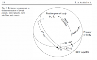
QUOTE (Bjorn Jonsson @ Aug 11 2015, 12:25 AM)  Regarding NH's trajectory, if I remember correctly the flyby didn't occur at exactly the planned time (off by some seconds but well within the required accuracy) and this makes it more tricky to use the metadata to accurately determine the viewing geometry (especially in the hi-res images) until an updated trajectory (SPICE kernels) becomes avvailable. At first I tried to use the data from http://ssd.jpl.nasa.gov/horizons.cgi#top 2457218.000000000 = A.D. 2015-Jul-14 12:00:00.0000 (CT) NH: r[km] 1.197739374505814E+09 -4.443897760753548E+09 -1.747680731829689E+09 v[km/s] 5.534336802447741E+00 -1.252001712778965E+01 -4.846832563458260E+00 Pluto: 1.197726655664916E+09 -4.443893298780707E+09 -1.747673432906277E+09 5.379986303470789E+00 8.159673817708096E-01 -1.389030301906091E+00 Charon: 1.197712275411875E+09 -4.443906278626040E+09 -1.747670469452485E+09 5.388459229072444E+00 8.566266433864180E-01 -1.169827709122328E+00 but I found that the position of NH was displaced approximately 120 seconds, so I used the least squares method (with using distances to Pluto, Charon, Nix and Hydra up to 2,000,000 km) to made a correction of 3D position (about 1,665 kilometers) and velocity vector (about 11.6 m/s) so that the simulated distances become coincide to metadata with an error of about 0.1 km. r0_NH {1.1977391023383e9, -4.44389934311302e9, -1.74768117382772e9} v0_NH {5.53196172582933, -12.51701129448342, -4.85774060000822} For the calculation of rotation of Pluto and Charon, I used data from http://link.springer.com/article/10.1007%2Fs10569-010-9320-4 North pole: alpha0=132°.993, delta0=-6°.163, turn: W=237°.305+56°.3625225d
but turn does not coincide with data from http://ssd.jpl.nasa.gov/horizons.cgi#top so I use turn W=304°.155524+56°.3625225d and changed GM=873.22336378 km^3/s^2 for Pluto (instead 872.4 km^3/s^2). As a result I got the following location of Charon relative Pluto:
So if we take the Charon position as the origin point on Pluto, the ambiguity is not more than 0.1 degrees in latitude and 0.01 degrees in longitude. While for the purposes of mapping accuracy it is sufficient. QUOTE (scalbers @ Aug 11 2015, 02:16 AM) Interesting in that I had also noticed a North-South in my map compared with the official one near Tombaugh Regio. If we have the lat/lon subpoints readily available for the images (and if they are accurate) we can perhaps check and refine the maps better. The main ambiguity is in position of Pluto center in frames. The given in metadata values are too bad, so I adjust it manually. Only selfconsistent automatic map generation procedure can give accurate parameters... Now I generate grids for all available LORRI frames. To better quality size is doubled to 2048x2048. Steps are 1,5,10 and 30 degrees. For example:
You can get grids in folder "Grids" from ftp://gionov:NG@46.45.15.20/_Data/_LORRI/ The source images placed in "Source", simulated images in "Simulate". |
|||
|
|
|
|||
 Habukaz Pluto System Cartography Jul 28 2015, 08:17 PM
 stevesliva Cousteau Rupes! It's an escarpment!
... Jul 28 2015, 08:43 PM Gladstoner QUOTE (Habukaz @ Jul 28 2015, 03:17 PM) B... Jul 29 2015, 12:18 AM Exploitcorporations I've uploaded a version of the Johns Hopkins/S... Jul 29 2015, 03:10 AM
stevesliva Cousteau Rupes! It's an escarpment!
... Jul 28 2015, 08:43 PM Gladstoner QUOTE (Habukaz @ Jul 28 2015, 03:17 PM) B... Jul 29 2015, 12:18 AM Exploitcorporations I've uploaded a version of the Johns Hopkins/S... Jul 29 2015, 03:10 AM
 scalbers QUOTE (Exploitcorporations @ Jul 29 2015, 03... Jul 29 2015, 05:23 PM Bill Harris They have developed a unique naming strategy. At... Jul 29 2015, 11:42 AM scalbers Just a little cleanup for my Pluto map:
Full re... Jul 30 2015, 08:59 PM 4throck QUOTE (scalbers @ Jul 30 2015, 09:59 PM) ... Jul 31 2015, 02:06 PM scalbers QUOTE (4throck @ Jul 31 2015, 02:06 PM) A... Aug 4 2015, 06:45 PM nprev MOD NOTE: One post (& two responses to same) h... Jul 31 2015, 05:09 PM Exploitcorporations An exhaustive treatment of the proposed names from... Aug 2 2015, 02:39 AM Rob Pinnegar Nice to see that they have named large features af... Aug 6 2015, 06:01 PM Antdoghalo That's awesome, no more of that blank space... Aug 6 2015, 08:32 PM Gennady Ionov With the use of metadata of LORRI frames I clarify... Aug 10 2015, 07:35 PM Gennady Ionov Rebuilt pictures with the map
http://pluto.jhuapl.... Aug 10 2015, 08:46 PM Habukaz Bah, apparently there will be disagreement over th... Aug 26 2015, 10:02 AM Bill Harris IAU should have had at least a provisional, if not... Aug 26 2015, 01:25 PM JRehling Names are always a sign of the times, and Pluto... Aug 26 2015, 02:57 PM FOV It is Sputnik Planum AFAIC. The IAU can't chan... Aug 26 2015, 09:35 PM Phil Stooke Don't worry too much about names. Anyone can ... Aug 26 2015, 11:50 PM Herobrine I don't agree that names have the capacity to ... Aug 27 2015, 12:43 AM mcaplinger The topic of naming might be considered as an addi... Aug 27 2015, 03:55 AM nprev MOD NOTE: Recall that Aeolis Mons--as it is offici... Aug 27 2015, 04:23 AM Explorer1 Nothing wrong with multiple names as long as we st... Aug 27 2015, 06:21 AM Bill Harris "Ultreya" was hardly widespread and was... Aug 27 2015, 09:02 AM Habukaz The problem with more than one set of names is tha... Aug 27 2015, 10:09 AM JRehling A point of comparison:
The various Mars rovers ha... Aug 27 2015, 11:01 AM stevesliva QUOTE (JRehling @ Aug 27 2015, 07:01 AM) ... Aug 27 2015, 06:37 PM centsworth_II Mod is great! Aug 27 2015, 06:41 PM Nafnlaus Kneel Before Mod!
hehe... but anyway, given t... Sep 5 2015, 10:08 PM Gennady Ionov Icosahedral projection of Pluto map translated fro... Sep 6 2015, 08:03 AM Gennady Ionov Color icosahedral projection of Pluto map from sca... Sep 6 2015, 08:51 AM Bill Harris What an interesting projections. Could it be prin... Sep 6 2015, 11:35 AM Gennady Ionov QUOTE (Bill Harris @ Sep 6 2015, 04:35 PM... Sep 6 2015, 11:40 AM Gennady Ionov Printed
and glued icosahedron
It does not look a... Sep 6 2015, 12:47 PM ZLD HAHA!
Great seeing someone try it out Genn... Sep 6 2015, 01:40 PM Bill Harris QUOTE Yes, it is possible to glue the icosahedron.... Sep 6 2015, 04:04 PM chuckclark Might be me.
I made those foldable maps of sever... Sep 6 2015, 08:04 PM ngunn Also JRehling did one for Titan - see here: https:... Sep 6 2015, 08:24 PM ZLD My knowledge of cartography is pretty limited so a... Sep 6 2015, 09:39 PM Req QUOTE (ZLD @ Sep 6 2015, 02:39 PM) My kno... Sep 6 2015, 11:29 PM hendric QUOTE (Req @ Sep 6 2015, 05:29 PM) Or the... Sep 9 2015, 03:43 PM ZLD If it were that simple, I can promise that I would... Sep 7 2015, 02:35 AM MarsInMyLifetime Yesterday Greg Smyer-Rumsby of Astronomy Now tweet... Sep 7 2015, 03:03 AM Vaebn Hello folks. I've been a lurker for some time ... Sep 13 2015, 06:51 AM Gennady Ionov It's great! I also thought about how to pr... Sep 13 2015, 08:42 AM Bill Harris How neat-- I like your work. I've been inter... Sep 13 2015, 08:37 AM Bill Harris QUOTE (hendric)I couldn't determine if they sh... Sep 13 2015, 01:31 PM hendric Vaebn,
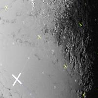
Great work! Bookmarked for future pr... Sep 14 2015, 01:54 PM Vaebn Bill (also see PM) / Gennady / Hendric. Thanks... Sep 15 2015, 01:37 AM scalbers I just put together a map version including some o... Sep 15 2015, 10:08 PM Habukaz QUOTE (scalbers @ Sep 16 2015, 12:08 AM) ... Sep 19 2015, 04:21 PM Gennady Ionov The first test of automatic map generation:
Pluto ... Sep 19 2015, 02:33 PM scalbers This question (referring to Yutu Linea) has a good... Sep 19 2015, 06:48 PM Gennady Ionov The next approximation:
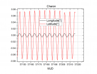
Pluto and Charon:
longit... Sep 20 2015, 05:44 AM Gennady Ionov I take a picture area of the sky, where was Pluto ... Sep 20 2015, 05:07 PM chuckclark A daisy petal foldable globe of Pluto is over here... Dec 20 2015, 08:12 PM Bill Harris Thanks, Chuck. Is a Charon foldable globe in th... Dec 21 2015, 10:02 PM chuckclark a Charon foldable globe?
Yes, Charon is on my rad... Dec 22 2015, 03:34 PM scalbers Would someone be able to remind me where the best ... Mar 18 2016, 05:25 PM ZLD As far as I know, this is the current best map ava... Mar 18 2016, 07:56 PM Bill Harris Have we ever gotten official Pluto-system names or... Mar 19 2016, 02:40 PM mcaplinger Other than the general categories, I don't see... Mar 19 2016, 03:56 PM alan I wonder if they have submitted the names, or if t... Mar 19 2016, 06:07 PM mcaplinger QUOTE (alan @ Mar 19 2016, 10:07 AM) I wo... Mar 19 2016, 07:03 PM alan QUOTE What does "too late" mean?
Just th... Mar 21 2016, 06:41 PM Bill Harris The IAU may been useful in the days when you docum... Mar 21 2016, 07:12 PM JRehling A tale I've mentioned before:
The USGS map an... Mar 21 2016, 10:14 PM Herobrine At home, I have a browser plug-in configured to re... Mar 22 2016, 01:53 PM mcaplinger QUOTE (Herobrine @ Mar 22 2016, 05:53 AM)... Mar 22 2016, 03:07 PM nprev MOD NOTE: Aaaaand that's the end of the IAU ta... Mar 22 2016, 11:49 PM JohnVV repost from a different forum
---
this is a VERY... Apr 26 2016, 10:29 PM alan NASAs New Horizons, IAU Set Pluto Naming Themes Feb 23 2017, 07:14 PM MarcF Finally, Pluto features got their first official n... Sep 7 2017, 04:12 PM Habukaz Pluto in Google Maps is quite nice: http://google.... Jan 3 2018, 08:01 PM stevesliva Charon IAU Nomenclature
http://pluto.jhuapl.edu/Ne... Apr 11 2018, 06:00 PM Antdoghalo I made this map of Charon by combining the 12K USG... Jun 20 2020, 12:56 AM Antdoghalo 16K Map of Pluto made by combining USGS map with a... Jul 5 2020, 01:03 PM Antdoghalo I recently got a new computer. With it, I have con... Nov 23 2020, 11:39 PM machi QUOTE (Antdoghalo @ Nov 24 2020, 12:39 AM... Dec 3 2020, 12:50 AM nprev Spectacular. Great work! Nov 24 2020, 01:01 AM Marcin600 I don't know if I'm posting this in the ri... Feb 4 2022, 07:40 PM mcaplinger QUOTE (Marcin600 @ Feb 4 2022, 11:40 AM) ... Feb 4 2022, 08:45 PM Marcin600 QUOTE (mcaplinger @ Feb 4 2022, 09:45 PM)... Feb 8 2022, 06:23 PM Marcin600 And here it is!!!
Thank you!
http... Feb 15 2022, 12:53 AM
scalbers QUOTE (Exploitcorporations @ Jul 29 2015, 03... Jul 29 2015, 05:23 PM Bill Harris They have developed a unique naming strategy. At... Jul 29 2015, 11:42 AM scalbers Just a little cleanup for my Pluto map:
Full re... Jul 30 2015, 08:59 PM 4throck QUOTE (scalbers @ Jul 30 2015, 09:59 PM) ... Jul 31 2015, 02:06 PM scalbers QUOTE (4throck @ Jul 31 2015, 02:06 PM) A... Aug 4 2015, 06:45 PM nprev MOD NOTE: One post (& two responses to same) h... Jul 31 2015, 05:09 PM Exploitcorporations An exhaustive treatment of the proposed names from... Aug 2 2015, 02:39 AM Rob Pinnegar Nice to see that they have named large features af... Aug 6 2015, 06:01 PM Antdoghalo That's awesome, no more of that blank space... Aug 6 2015, 08:32 PM Gennady Ionov With the use of metadata of LORRI frames I clarify... Aug 10 2015, 07:35 PM Gennady Ionov Rebuilt pictures with the map
http://pluto.jhuapl.... Aug 10 2015, 08:46 PM Habukaz Bah, apparently there will be disagreement over th... Aug 26 2015, 10:02 AM Bill Harris IAU should have had at least a provisional, if not... Aug 26 2015, 01:25 PM JRehling Names are always a sign of the times, and Pluto... Aug 26 2015, 02:57 PM FOV It is Sputnik Planum AFAIC. The IAU can't chan... Aug 26 2015, 09:35 PM Phil Stooke Don't worry too much about names. Anyone can ... Aug 26 2015, 11:50 PM Herobrine I don't agree that names have the capacity to ... Aug 27 2015, 12:43 AM mcaplinger The topic of naming might be considered as an addi... Aug 27 2015, 03:55 AM nprev MOD NOTE: Recall that Aeolis Mons--as it is offici... Aug 27 2015, 04:23 AM Explorer1 Nothing wrong with multiple names as long as we st... Aug 27 2015, 06:21 AM Bill Harris "Ultreya" was hardly widespread and was... Aug 27 2015, 09:02 AM Habukaz The problem with more than one set of names is tha... Aug 27 2015, 10:09 AM JRehling A point of comparison:
The various Mars rovers ha... Aug 27 2015, 11:01 AM stevesliva QUOTE (JRehling @ Aug 27 2015, 07:01 AM) ... Aug 27 2015, 06:37 PM centsworth_II Mod is great! Aug 27 2015, 06:41 PM Nafnlaus Kneel Before Mod!
hehe... but anyway, given t... Sep 5 2015, 10:08 PM Gennady Ionov Icosahedral projection of Pluto map translated fro... Sep 6 2015, 08:03 AM Gennady Ionov Color icosahedral projection of Pluto map from sca... Sep 6 2015, 08:51 AM Bill Harris What an interesting projections. Could it be prin... Sep 6 2015, 11:35 AM Gennady Ionov QUOTE (Bill Harris @ Sep 6 2015, 04:35 PM... Sep 6 2015, 11:40 AM Gennady Ionov Printed
and glued icosahedron
It does not look a... Sep 6 2015, 12:47 PM ZLD HAHA!
Great seeing someone try it out Genn... Sep 6 2015, 01:40 PM Bill Harris QUOTE Yes, it is possible to glue the icosahedron.... Sep 6 2015, 04:04 PM chuckclark Might be me.
I made those foldable maps of sever... Sep 6 2015, 08:04 PM ngunn Also JRehling did one for Titan - see here: https:... Sep 6 2015, 08:24 PM ZLD My knowledge of cartography is pretty limited so a... Sep 6 2015, 09:39 PM Req QUOTE (ZLD @ Sep 6 2015, 02:39 PM) My kno... Sep 6 2015, 11:29 PM hendric QUOTE (Req @ Sep 6 2015, 05:29 PM) Or the... Sep 9 2015, 03:43 PM ZLD If it were that simple, I can promise that I would... Sep 7 2015, 02:35 AM MarsInMyLifetime Yesterday Greg Smyer-Rumsby of Astronomy Now tweet... Sep 7 2015, 03:03 AM Vaebn Hello folks. I've been a lurker for some time ... Sep 13 2015, 06:51 AM Gennady Ionov It's great! I also thought about how to pr... Sep 13 2015, 08:42 AM Bill Harris How neat-- I like your work. I've been inter... Sep 13 2015, 08:37 AM Bill Harris QUOTE (hendric)I couldn't determine if they sh... Sep 13 2015, 01:31 PM hendric Vaebn,
Great work! Bookmarked for future pr... Sep 14 2015, 01:54 PM Vaebn Bill (also see PM) / Gennady / Hendric. Thanks... Sep 15 2015, 01:37 AM scalbers I just put together a map version including some o... Sep 15 2015, 10:08 PM Habukaz QUOTE (scalbers @ Sep 16 2015, 12:08 AM) ... Sep 19 2015, 04:21 PM Gennady Ionov The first test of automatic map generation:
Pluto ... Sep 19 2015, 02:33 PM scalbers This question (referring to Yutu Linea) has a good... Sep 19 2015, 06:48 PM Gennady Ionov The next approximation:
Pluto and Charon:
longit... Sep 20 2015, 05:44 AM Gennady Ionov I take a picture area of the sky, where was Pluto ... Sep 20 2015, 05:07 PM chuckclark A daisy petal foldable globe of Pluto is over here... Dec 20 2015, 08:12 PM Bill Harris Thanks, Chuck. Is a Charon foldable globe in th... Dec 21 2015, 10:02 PM chuckclark a Charon foldable globe?
Yes, Charon is on my rad... Dec 22 2015, 03:34 PM scalbers Would someone be able to remind me where the best ... Mar 18 2016, 05:25 PM ZLD As far as I know, this is the current best map ava... Mar 18 2016, 07:56 PM Bill Harris Have we ever gotten official Pluto-system names or... Mar 19 2016, 02:40 PM mcaplinger Other than the general categories, I don't see... Mar 19 2016, 03:56 PM alan I wonder if they have submitted the names, or if t... Mar 19 2016, 06:07 PM mcaplinger QUOTE (alan @ Mar 19 2016, 10:07 AM) I wo... Mar 19 2016, 07:03 PM alan QUOTE What does "too late" mean?
Just th... Mar 21 2016, 06:41 PM Bill Harris The IAU may been useful in the days when you docum... Mar 21 2016, 07:12 PM JRehling A tale I've mentioned before:
The USGS map an... Mar 21 2016, 10:14 PM Herobrine At home, I have a browser plug-in configured to re... Mar 22 2016, 01:53 PM mcaplinger QUOTE (Herobrine @ Mar 22 2016, 05:53 AM)... Mar 22 2016, 03:07 PM nprev MOD NOTE: Aaaaand that's the end of the IAU ta... Mar 22 2016, 11:49 PM JohnVV repost from a different forum
---
this is a VERY... Apr 26 2016, 10:29 PM alan NASAs New Horizons, IAU Set Pluto Naming Themes Feb 23 2017, 07:14 PM MarcF Finally, Pluto features got their first official n... Sep 7 2017, 04:12 PM Habukaz Pluto in Google Maps is quite nice: http://google.... Jan 3 2018, 08:01 PM stevesliva Charon IAU Nomenclature
http://pluto.jhuapl.edu/Ne... Apr 11 2018, 06:00 PM Antdoghalo I made this map of Charon by combining the 12K USG... Jun 20 2020, 12:56 AM Antdoghalo 16K Map of Pluto made by combining USGS map with a... Jul 5 2020, 01:03 PM Antdoghalo I recently got a new computer. With it, I have con... Nov 23 2020, 11:39 PM machi QUOTE (Antdoghalo @ Nov 24 2020, 12:39 AM... Dec 3 2020, 12:50 AM nprev Spectacular. Great work! Nov 24 2020, 01:01 AM Marcin600 I don't know if I'm posting this in the ri... Feb 4 2022, 07:40 PM mcaplinger QUOTE (Marcin600 @ Feb 4 2022, 11:40 AM) ... Feb 4 2022, 08:45 PM Marcin600 QUOTE (mcaplinger @ Feb 4 2022, 09:45 PM)... Feb 8 2022, 06:23 PM Marcin600 And here it is!!!
Thank you!
http... Feb 15 2022, 12:53 AM |

|
Lo-Fi Version | Time is now: 27th September 2024 - 03:18 AM |
|
RULES AND GUIDELINES Please read the Forum Rules and Guidelines before posting. IMAGE COPYRIGHT |
OPINIONS AND MODERATION Opinions expressed on UnmannedSpaceflight.com are those of the individual posters and do not necessarily reflect the opinions of UnmannedSpaceflight.com or The Planetary Society. The all-volunteer UnmannedSpaceflight.com moderation team is wholly independent of The Planetary Society. The Planetary Society has no influence over decisions made by the UnmannedSpaceflight.com moderators. |
SUPPORT THE FORUM Unmannedspaceflight.com is funded by the Planetary Society. Please consider supporting our work and many other projects by donating to the Society or becoming a member. |
|