Chang'e 5 sample return mission |

Chang'e 5 sample return mission |
 Oct 24 2012, 01:02 PM Oct 24 2012, 01:02 PM
Post
#31
|
|
|
Solar System Cartographer  Group: Members Posts: 10226 Joined: 5-April 05 From: Canada Member No.: 227 |
Of course, a mechanical or electronic failure is likely to end the mission long before the RTG wears out (same as on Curiosity)
Phil -------------------- ... because the Solar System ain't gonna map itself.
Also to be found posting similar content on https://mastodon.social/@PhilStooke Maps for download (free PDF: https://upload.wikimedia.org/wikipedia/comm...Cartography.pdf NOTE: everything created by me which I post on UMSF is considered to be in the public domain (NOT CC, public domain) |
 |
 
|
 |
|
Nov 6 2012, 12:28 AM
Post
#32
|
||
|
Junior Member Group: Members Posts: 86 Joined: 12-October 05 From: Beijing Member No.: 526 |
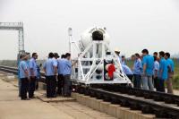
Chang'e 5 atmospheric re-entry and parachute ejection system tested.
Attached thumbnail(s)
|
|
|
|
|
|
|
Sep 2 2015, 11:06 PM
Post
#33
|
|
|
Solar System Cartographer Group: Members Posts: 10226 Joined: 5-April 05 From: Canada Member No.: 227 |
One way to interpret the Chinese text is that this imaging from 30 Aug. to 2 Sept completed the imaging of the fifth potential landing site. I don't know where any of them are yet - if anyone knows please let me know. But nice to know there are five candidates.
EDIT - the more I think about it, the more I suspect that the 'fifth' referred to is the fifth spacecraft, Chang'E 5. Google Translate is a blunt instrument for probing difficult questions. There might only be one site after all. I hope we will learn more soon. EDIT AGAIN - a bit of detective work. The terminator was crossing the Mare Crisium area over the few days the images were taken. I had been expecting a landing in Oceanus Procellarum, but the sun would have been overhead there, and these images have shadows suggesting a lower sun elevation. Possibly a site in the eastern maria, but west of Crisium. Not much to go on yet. Phil -------------------- ... because the Solar System ain't gonna map itself.
Also to be found posting similar content on https://mastodon.social/@PhilStooke Maps for download (free PDF: https://upload.wikimedia.org/wikipedia/comm...Cartography.pdf NOTE: everything created by me which I post on UMSF is considered to be in the public domain (NOT CC, public domain) |
|
|
|
|
Sep 3 2015, 07:01 AM
Post
#34
|
|
 Senior Member Group: Members Posts: 1729 Joined: 3-August 06 From: 43° 35' 53" N 1° 26' 35" E Member No.: 1004 |
QUOTE (Phil Stooke @ Sep 3 2015, 01:06 AM)  One way to interpret the Chinese text is that this imaging from 30 Aug. to 2 Sept completed the imaging of the fifth potential landing site. there is also a release in English here: China's lunar orbiter gets close-up pictures of the Moon it is clearly stated that the orbiter imaged the landing site of CE-5 |
|
|
|
 yaohua2000 Chang'e 5 sample return mission Nov 6 2012, 12:28 AM
 dvandorn "Blackstar" on that forum is a science a... Oct 18 2014, 02:28 AM Paolo as fare as I know, CE-5 will not carry a rover. sa... Oct 18 2014, 07:15 AM dvandorn Okay, kewl. A rather less robust geological explo... Oct 18 2014, 12:39 PM William Pei New lunar mission to test Chang'e-5 technology... Oct 23 2014, 02:13 AM tolis ..and it's off:
http://www.spaceflight101.com... Oct 23 2014, 09:31 PM A.Nemo Before first TCM,CE5T1 take a photo of eart... Oct 24 2014, 01:57 PM
dvandorn "Blackstar" on that forum is a science a... Oct 18 2014, 02:28 AM Paolo as fare as I know, CE-5 will not carry a rover. sa... Oct 18 2014, 07:15 AM dvandorn Okay, kewl. A rather less robust geological explo... Oct 18 2014, 12:39 PM William Pei New lunar mission to test Chang'e-5 technology... Oct 23 2014, 02:13 AM tolis ..and it's off:
http://www.spaceflight101.com... Oct 23 2014, 09:31 PM A.Nemo Before first TCM,CE5T1 take a photo of eart... Oct 24 2014, 01:57 PM
 climber QUOTE (A.Nemo @ Oct 24 2014, 03:57 PM) Be... Oct 24 2014, 07:14 PM dvandorn Looks like a black-and-white picture of Earth that... Oct 24 2014, 03:06 PM Paolo would be interesting to know whether it comes from... Oct 24 2014, 03:56 PM Astro0 "...tinted blue."
More likely just the ... Oct 25 2014, 06:51 AM dvandorn Yeah, possibly a monitor issue. But there are no ... Oct 25 2014, 12:34 PM A.Nemo perhaps when CE5T1 reentry,there will be a ... Oct 26 2014, 08:29 AM Paolo I didn't notice it before... the phase of the ... Oct 26 2014, 08:36 AM A.Nemo CE-5T1 has taken some photos of moon and earth... Oct 28 2014, 01:15 PM Phil Stooke Yes, very beautiful. That's Mare Marginis and... Oct 28 2014, 01:26 PM Cosmic Penguin QUOTE (A.Nemo @ Oct 28 2014, 09:15 PM) CE... Oct 28 2014, 02:33 PM dvandorn Now, *that* ain't a tinted-blue B&W pic of... Oct 28 2014, 03:06 PM elakdawalla Phil, Cosmic Penguin: what do you think the correc... Oct 28 2014, 03:58 PM Phil Stooke My best guess is CAST - the China Academy of Space... Oct 28 2014, 04:40 PM ngunn I can't make sense of the illumination angle i... Oct 28 2014, 04:47 PM nprev Successful reentry and landing! Here's Emi... Nov 1 2014, 12:23 AM nprev I can't find an English-language source for th... Nov 1 2014, 12:26 AM SpaceListener http://www.spacedaily.com/reports/China_co...d_bac... Nov 1 2014, 12:31 AM A.Nemo QUOTE (nprev @ Nov 1 2014, 08:26 AM) I ca... Nov 1 2014, 02:31 AM nprev Thanks. I was looking for something with more deta... Nov 1 2014, 02:06 AM Yeh I am relaying some images taken by a PLA journalis... Nov 1 2014, 02:18 AM Yeh QUOTE (Yeh @ Oct 31 2014, 09:18 PM) I am ... Nov 1 2014, 02:58 AM nprev Thank you VERY much, Yeh and A. Nemo. Congratulati... Nov 1 2014, 07:54 AM Yeh http://www.81.cn/jwgz/2014-11/01/content_6206266.h... Nov 2 2014, 03:25 AM nprev Really! That's unexpected, and very intere... Nov 2 2014, 03:47 AM Yeh QUOTE (nprev @ Nov 1 2014, 10:47 PM) Real... Nov 2 2014, 04:57 PM Paolo the L2 extension clearly shows that they are consi... Nov 2 2014, 07:04 AM Phil Stooke I have not heard of any extension. Conceivably Ch... Nov 2 2014, 02:39 PM elakdawalla QUOTE (Phil Stooke @ Nov 2 2014, 06:39 AM... Nov 3 2014, 05:22 PM Phil Stooke Chang'E 2 only obtained the very high resoluti... Nov 3 2014, 09:41 PM A.Nemo SASTIND have released a new photo of earth and moo... Nov 10 2014, 12:22 PM A.Nemo http://china.cnr.cn/gdgg/201411/t20141129_51692280... Nov 29 2014, 08:55 AM Paolo this xinhua article discusses future plans for CE5... Dec 3 2014, 06:39 AM Phil Stooke " lunar exploration phase III reentry return ... Dec 3 2014, 02:53 PM Paolo If I understand correctly, the probe has been nick... Dec 3 2014, 03:04 PM Phil Stooke Ah... that's the connection. Very interesting... Dec 3 2014, 03:57 PM Thorsten Denk Cháng'é-5 T1 (or what's remaining from it)... Jan 6 2015, 09:21 AM Cosmic Penguin In summary:
CE-5-T1 left EM-L2 at around 15:00 UT... Jan 6 2015, 02:35 PM Cosmic Penguin And CE-5-T1 has entered lunar orbit yesterday at a... Jan 11 2015, 05:29 AM Phil Stooke Anatoly Zak has an article here with images of Ear... Jan 14 2015, 01:42 PM Explorer1 A lower orbit now: http://spaceflightnow.com/2015/... Jan 22 2015, 04:34 AM Phil Stooke Suggestions have been circulated that the region w... Jan 22 2015, 01:39 PM kenny Leonard David has posted this visualisation of the... Feb 8 2015, 10:32 PM Phil Stooke http://www.cast.cn/CastCn/Show.asp?ArticleID=48907... Jul 17 2015, 01:03 AM Explorer1 Was the full mosaic in this article released alrea... Jul 17 2015, 01:50 AM Phil Stooke Yes, that has been out for a while.
Phil Jul 17 2015, 06:50 AM Yeh CE5T1 completes imaging CE5's landing zone: ht... Sep 2 2015, 09:46 PM Nordren QUOTE (Yeh @ Sep 3 2015, 12:46 AM) CE5T1 ... Sep 2 2015, 09:55 PM elakdawalla Is there anything that indicates whether Chang... Sep 3 2015, 03:13 PM elakdawalla Came across this July 29 item on the CAST website ... Sep 3 2015, 04:29 PM Yeh QUOTE (Phil Stooke @ Sep 2 2015, 06:06 PM... Sep 3 2015, 05:14 PM Phil Stooke https://agu.confex.com/agu/fm15/meetingapp.cgi/Pap... Oct 12 2015, 05:17 PM Phil Stooke Tweet from IAC:
Peter B. de Selding @pbdes... Oct 13 2015, 03:49 PM tolis The web site of this conference links to a nice co... May 26 2016, 01:51 PM Phil Stooke This is the same information presented at LPSC. A... May 26 2016, 08:14 PM Paolo QUOTE (Phil Stooke @ May 26 2016, 09:14 P... May 27 2016, 01:10 PM Phil Stooke https://www.chinaspaceflight.com/satellite/.../CE-... Jan 1 2017, 10:21 PM Phil Stooke Update on Chang'E 5 landing site selection. N... Mar 2 2017, 12:44 AM Holder of the Two Leashes QUOTE (Phil Stooke @ Mar 1 2017, 06:44 PM... Mar 2 2017, 02:36 PM Phil Stooke And a closer view of the target area - it's th... Mar 2 2017, 12:59 AM Phil Stooke An updated map of the landing area.
Phil
Mar 2 2017, 06:50 PM Phil Stooke And finally, to show that the precursor mission Ch... Mar 6 2017, 04:25 AM Phil Stooke I have located the second image now, on the wester... Mar 15 2017, 02:20 PM Phil Stooke CE5-T1 second image located.
Phil
Mar 15 2017, 03:46 PM Phil Stooke I have learned some new things about the CE5 landi... Jun 22 2017, 05:13 AM Phil Stooke More on those sites later. Meanwhile, here's ... Jun 23 2017, 12:52 AM Phil Stooke Sad news. A second launch of the large new rocket... Jul 2 2017, 04:45 PM Paolo let's look at the bright side: maybe CE-4 will... Jul 2 2017, 06:37 PM Phil Stooke https://twitter.com/jeff_foust/status/912197913995... Sep 25 2017, 10:50 AM Phil Stooke Chang'E 5 T1, the mission which tested the ret... Dec 14 2017, 11:16 PM Phil Stooke Confirmation CE5 T1 is still operating in lunar or... Jan 12 2018, 07:26 AM Steve G Update on the long March 5 failure and schedule fo... Apr 16 2018, 12:34 PM Huguet Let's hope they acelerate their program due to... Jan 17 2019, 02:58 PM SpaceListener QUOTE (Huguet @ Jan 17 2019, 08:58 AM) Le... Jan 17 2019, 03:22 PM nogal Quote from the ESA "Beckoning Moon" post... Jan 25 2019, 10:38 PM Thorsten Denk Long March 5 return to flight in July.
If all goes... Jan 29 2019, 12:49 PM Huguet https://futurism.com/the-byte/china-launche...-mar... Dec 31 2019, 01:42 PM Paolo some scientific results from the lunar orbiting ph... Apr 17 2020, 05:22 PM Huguet Andrew Jones - https://twitter.com/AJ_FI/status/12... Jul 23 2020, 12:23 PM Phil Stooke Launch next week! Here's an interesting p... Nov 19 2020, 05:19 AM nogal QUOTE (Phil Stooke @ Nov 19 2020, 05:19 A... Nov 19 2020, 06:21 PM Phil Stooke I forgot to mention in my recent post that there i... Nov 21 2020, 08:39 PM Thorsten Denk Possible Cháng'é 5 timeline (in UTC). From ... Nov 23 2020, 08:33 AM Ron Hobbs From an article by Sam McNeil in the Washington Po... Nov 23 2020, 03:21 PM Ron Hobbs CGTN is webcasting live coverage of the Chang... Nov 23 2020, 07:44 PM nprev Anybody have a link?
EDIT: Here. Nov 23 2020, 08:12 PM nprev Spacecraft sep. Looks like a sweet launch. Here... Nov 23 2020, 09:25 PM Huguet Solar arrays deployed, the chinese are pretty conf... Nov 24 2020, 09:17 AM fredk S&T reports landing planned for "on or ar... Nov 24 2020, 05:53 PM Brian Swift Solar panel video from data captured and decoded b... Nov 25 2020, 08:24 PM Explorer1 Nice work for them! This is like the Luna 9 su... Nov 25 2020, 09:38 PM kenny Latest news from South China Morning Post (Hong Ko... Nov 26 2020, 10:27 PM
climber QUOTE (A.Nemo @ Oct 24 2014, 03:57 PM) Be... Oct 24 2014, 07:14 PM dvandorn Looks like a black-and-white picture of Earth that... Oct 24 2014, 03:06 PM Paolo would be interesting to know whether it comes from... Oct 24 2014, 03:56 PM Astro0 "...tinted blue."
More likely just the ... Oct 25 2014, 06:51 AM dvandorn Yeah, possibly a monitor issue. But there are no ... Oct 25 2014, 12:34 PM A.Nemo perhaps when CE5T1 reentry,there will be a ... Oct 26 2014, 08:29 AM Paolo I didn't notice it before... the phase of the ... Oct 26 2014, 08:36 AM A.Nemo CE-5T1 has taken some photos of moon and earth... Oct 28 2014, 01:15 PM Phil Stooke Yes, very beautiful. That's Mare Marginis and... Oct 28 2014, 01:26 PM Cosmic Penguin QUOTE (A.Nemo @ Oct 28 2014, 09:15 PM) CE... Oct 28 2014, 02:33 PM dvandorn Now, *that* ain't a tinted-blue B&W pic of... Oct 28 2014, 03:06 PM elakdawalla Phil, Cosmic Penguin: what do you think the correc... Oct 28 2014, 03:58 PM Phil Stooke My best guess is CAST - the China Academy of Space... Oct 28 2014, 04:40 PM ngunn I can't make sense of the illumination angle i... Oct 28 2014, 04:47 PM nprev Successful reentry and landing! Here's Emi... Nov 1 2014, 12:23 AM nprev I can't find an English-language source for th... Nov 1 2014, 12:26 AM SpaceListener http://www.spacedaily.com/reports/China_co...d_bac... Nov 1 2014, 12:31 AM A.Nemo QUOTE (nprev @ Nov 1 2014, 08:26 AM) I ca... Nov 1 2014, 02:31 AM nprev Thanks. I was looking for something with more deta... Nov 1 2014, 02:06 AM Yeh I am relaying some images taken by a PLA journalis... Nov 1 2014, 02:18 AM Yeh QUOTE (Yeh @ Oct 31 2014, 09:18 PM) I am ... Nov 1 2014, 02:58 AM nprev Thank you VERY much, Yeh and A. Nemo. Congratulati... Nov 1 2014, 07:54 AM Yeh http://www.81.cn/jwgz/2014-11/01/content_6206266.h... Nov 2 2014, 03:25 AM nprev Really! That's unexpected, and very intere... Nov 2 2014, 03:47 AM Yeh QUOTE (nprev @ Nov 1 2014, 10:47 PM) Real... Nov 2 2014, 04:57 PM Paolo the L2 extension clearly shows that they are consi... Nov 2 2014, 07:04 AM Phil Stooke I have not heard of any extension. Conceivably Ch... Nov 2 2014, 02:39 PM elakdawalla QUOTE (Phil Stooke @ Nov 2 2014, 06:39 AM... Nov 3 2014, 05:22 PM Phil Stooke Chang'E 2 only obtained the very high resoluti... Nov 3 2014, 09:41 PM A.Nemo SASTIND have released a new photo of earth and moo... Nov 10 2014, 12:22 PM A.Nemo http://china.cnr.cn/gdgg/201411/t20141129_51692280... Nov 29 2014, 08:55 AM Paolo this xinhua article discusses future plans for CE5... Dec 3 2014, 06:39 AM Phil Stooke " lunar exploration phase III reentry return ... Dec 3 2014, 02:53 PM Paolo If I understand correctly, the probe has been nick... Dec 3 2014, 03:04 PM Phil Stooke Ah... that's the connection. Very interesting... Dec 3 2014, 03:57 PM Thorsten Denk Cháng'é-5 T1 (or what's remaining from it)... Jan 6 2015, 09:21 AM Cosmic Penguin In summary:
CE-5-T1 left EM-L2 at around 15:00 UT... Jan 6 2015, 02:35 PM Cosmic Penguin And CE-5-T1 has entered lunar orbit yesterday at a... Jan 11 2015, 05:29 AM Phil Stooke Anatoly Zak has an article here with images of Ear... Jan 14 2015, 01:42 PM Explorer1 A lower orbit now: http://spaceflightnow.com/2015/... Jan 22 2015, 04:34 AM Phil Stooke Suggestions have been circulated that the region w... Jan 22 2015, 01:39 PM kenny Leonard David has posted this visualisation of the... Feb 8 2015, 10:32 PM Phil Stooke http://www.cast.cn/CastCn/Show.asp?ArticleID=48907... Jul 17 2015, 01:03 AM Explorer1 Was the full mosaic in this article released alrea... Jul 17 2015, 01:50 AM Phil Stooke Yes, that has been out for a while.
Phil Jul 17 2015, 06:50 AM Yeh CE5T1 completes imaging CE5's landing zone: ht... Sep 2 2015, 09:46 PM Nordren QUOTE (Yeh @ Sep 3 2015, 12:46 AM) CE5T1 ... Sep 2 2015, 09:55 PM elakdawalla Is there anything that indicates whether Chang... Sep 3 2015, 03:13 PM elakdawalla Came across this July 29 item on the CAST website ... Sep 3 2015, 04:29 PM Yeh QUOTE (Phil Stooke @ Sep 2 2015, 06:06 PM... Sep 3 2015, 05:14 PM Phil Stooke https://agu.confex.com/agu/fm15/meetingapp.cgi/Pap... Oct 12 2015, 05:17 PM Phil Stooke Tweet from IAC:
Peter B. de Selding @pbdes... Oct 13 2015, 03:49 PM tolis The web site of this conference links to a nice co... May 26 2016, 01:51 PM Phil Stooke This is the same information presented at LPSC. A... May 26 2016, 08:14 PM Paolo QUOTE (Phil Stooke @ May 26 2016, 09:14 P... May 27 2016, 01:10 PM Phil Stooke https://www.chinaspaceflight.com/satellite/.../CE-... Jan 1 2017, 10:21 PM Phil Stooke Update on Chang'E 5 landing site selection. N... Mar 2 2017, 12:44 AM Holder of the Two Leashes QUOTE (Phil Stooke @ Mar 1 2017, 06:44 PM... Mar 2 2017, 02:36 PM Phil Stooke And a closer view of the target area - it's th... Mar 2 2017, 12:59 AM Phil Stooke An updated map of the landing area.
Phil
Mar 2 2017, 06:50 PM Phil Stooke And finally, to show that the precursor mission Ch... Mar 6 2017, 04:25 AM Phil Stooke I have located the second image now, on the wester... Mar 15 2017, 02:20 PM Phil Stooke CE5-T1 second image located.
Phil
Mar 15 2017, 03:46 PM Phil Stooke I have learned some new things about the CE5 landi... Jun 22 2017, 05:13 AM Phil Stooke More on those sites later. Meanwhile, here's ... Jun 23 2017, 12:52 AM Phil Stooke Sad news. A second launch of the large new rocket... Jul 2 2017, 04:45 PM Paolo let's look at the bright side: maybe CE-4 will... Jul 2 2017, 06:37 PM Phil Stooke https://twitter.com/jeff_foust/status/912197913995... Sep 25 2017, 10:50 AM Phil Stooke Chang'E 5 T1, the mission which tested the ret... Dec 14 2017, 11:16 PM Phil Stooke Confirmation CE5 T1 is still operating in lunar or... Jan 12 2018, 07:26 AM Steve G Update on the long March 5 failure and schedule fo... Apr 16 2018, 12:34 PM Huguet Let's hope they acelerate their program due to... Jan 17 2019, 02:58 PM SpaceListener QUOTE (Huguet @ Jan 17 2019, 08:58 AM) Le... Jan 17 2019, 03:22 PM nogal Quote from the ESA "Beckoning Moon" post... Jan 25 2019, 10:38 PM Thorsten Denk Long March 5 return to flight in July.
If all goes... Jan 29 2019, 12:49 PM Huguet https://futurism.com/the-byte/china-launche...-mar... Dec 31 2019, 01:42 PM Paolo some scientific results from the lunar orbiting ph... Apr 17 2020, 05:22 PM Huguet Andrew Jones - https://twitter.com/AJ_FI/status/12... Jul 23 2020, 12:23 PM Phil Stooke Launch next week! Here's an interesting p... Nov 19 2020, 05:19 AM nogal QUOTE (Phil Stooke @ Nov 19 2020, 05:19 A... Nov 19 2020, 06:21 PM Phil Stooke I forgot to mention in my recent post that there i... Nov 21 2020, 08:39 PM Thorsten Denk Possible Cháng'é 5 timeline (in UTC). From ... Nov 23 2020, 08:33 AM Ron Hobbs From an article by Sam McNeil in the Washington Po... Nov 23 2020, 03:21 PM Ron Hobbs CGTN is webcasting live coverage of the Chang... Nov 23 2020, 07:44 PM nprev Anybody have a link?
EDIT: Here. Nov 23 2020, 08:12 PM nprev Spacecraft sep. Looks like a sweet launch. Here... Nov 23 2020, 09:25 PM Huguet Solar arrays deployed, the chinese are pretty conf... Nov 24 2020, 09:17 AM fredk S&T reports landing planned for "on or ar... Nov 24 2020, 05:53 PM Brian Swift Solar panel video from data captured and decoded b... Nov 25 2020, 08:24 PM Explorer1 Nice work for them! This is like the Luna 9 su... Nov 25 2020, 09:38 PM kenny Latest news from South China Morning Post (Hong Ko... Nov 26 2020, 10:27 PM |

|
Lo-Fi Version | Time is now: 22nd September 2024 - 04:07 AM |
|
RULES AND GUIDELINES Please read the Forum Rules and Guidelines before posting. IMAGE COPYRIGHT |
OPINIONS AND MODERATION Opinions expressed on UnmannedSpaceflight.com are those of the individual posters and do not necessarily reflect the opinions of UnmannedSpaceflight.com or The Planetary Society. The all-volunteer UnmannedSpaceflight.com moderation team is wholly independent of The Planetary Society. The Planetary Society has no influence over decisions made by the UnmannedSpaceflight.com moderators. |
SUPPORT THE FORUM Unmannedspaceflight.com is funded by the Planetary Society. Please consider supporting our work and many other projects by donating to the Society or becoming a member. |
|