Himawari |

Himawari |
 Jul 21 2015, 05:20 PM Jul 21 2015, 05:20 PM
Post
#1
|
||
 Senior Member  Group: Members Posts: 1669 Joined: 5-March 05 From: Boulder, CO Member No.: 184 |
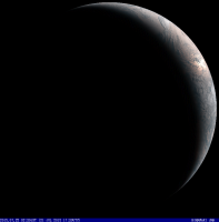
Here is a real-time full color view of the Earth from the Himawari satellite, updated every half hour or so. This geostationary weather satellite is stationed over the longitude of Japan. The view is complete with orange sunglint off the ocean. You can click on the link to see the latest update.
http://www.jma.go.jp/en/gms/largec.html?ar...=1&mode=UTC I previously posted this high resolution sample image in the Whole Earth Images thread. We can look around for the full resolution real-time data archive that would be about 11000 pixels wide. -------------------- Steve [ my home page and planetary maps page ]
|
|
 |
 
|
|
 |
|
Nov 13 2015, 03:19 AM
Post
#2
|
|
 Junior Member Group: Members Posts: 23 Joined: 15-February 14 Member No.: 7141 |
Thanks for saying so
 I went away on vacation, and when I got back, I realized my scripts had gone haywire while I was gone. Due to a combination of lack of spare time, code bugs, and what I eventually diagnosed as bad Linux support for my hard drive's file system format, I haven't quite gotten the whole pipeline fully running again yet. But I just got a new drive which I'm reformatting and plan to try again tonight. I went away on vacation, and when I got back, I realized my scripts had gone haywire while I was gone. Due to a combination of lack of spare time, code bugs, and what I eventually diagnosed as bad Linux support for my hard drive's file system format, I haven't quite gotten the whole pipeline fully running again yet. But I just got a new drive which I'm reformatting and plan to try again tonight.More excitingly, I've been in contact with Steve Miller at NOAA/CIRA who just returned from Tokyo where he presented their awesome new Himawari 8 Geocolor product (as well as one of my interpolated videos  ). Geocolor adds night coverage via a combination of infrared cloud imagery and a static city lights background layer. It's similar to their GOES Geocolor product. From an email: ). Geocolor adds night coverage via a combination of infrared cloud imagery and a static city lights background layer. It's similar to their GOES Geocolor product. From an email:QUOTE CIRA has been working on generating Steve Miller's Geocolor product from Himawari-8. There are three notable improvements over the GOES version: 1) The daytime background is no longer static - the daytime imagery is now the Hybrid Atmospherically Corrected True Color 2) The nighttime city lights are based on a new 1-km dataset built from 1 year of VIIRS Day Night Band data. The lights are still static, but the resolution is improved over the GOES version. 3) The product is higher resolution in both space (1 km) and time (10 minutes) for the full disk. For the nighttime portion, white colors are high ice clouds, and the reddish colors represent lower liquid water clouds. We of course plan to generate a similar product from the GOES-R ABI. The current version from Himawari is experimental and we'll be working on improvements over the next year. This replaces their previous RGB daytime product, so as of 2015-11-11 20:40 all of the images in the RAMMB/CIRA archive have night-time Geocolor coverage. You'll see these showing up in my new videos on Youtube in a day or two. Very cool stuff. -d |
|
|
|
 scalbers Himawari Jul 21 2015, 05:20 PM
 lyford Wonderful! Thank you. Jul 22 2015, 08:03 AM scalbers Another view with a gibbous Earth:
Jul 29 2015, 12:03 AM djellison I've tried ( but failed ) to find a source for... Jul 29 2015, 12:09 AM
lyford Wonderful! Thank you. Jul 22 2015, 08:03 AM scalbers Another view with a gibbous Earth:
Jul 29 2015, 12:03 AM djellison I've tried ( but failed ) to find a source for... Jul 29 2015, 12:09 AM
 johnmerritt Not the full res data, but I was able to locate fo... Jul 29 2015, 05:56 AM MahFL You can see the clearly on the images the North Po... Jul 29 2015, 01:57 PM scalbers Good detective work and mosaic johnmerrit! Her... Jul 29 2015, 06:42 PM stevesliva QUOTE (scalbers @ Jul 29 2015, 02:42 PM) ... Jul 30 2015, 12:10 AM xflare The full disk images are now at full resolution. ... Aug 7 2015, 04:29 PM scalbers Sounds intriguing. Is there a link where the full-... Aug 7 2015, 05:35 PM stevesliva Visible (Color) imagery, including animations, her... Aug 7 2015, 05:52 PM xflare I got them here http://rammb.cira.colostate.edu/ra... Aug 7 2015, 06:03 PM scalbers Nice - however the full color ones look to be proc... Aug 7 2015, 06:22 PM scalbers Here is a bit of info on a planned mechanism to ma... Aug 14 2015, 05:08 PM Dan Delany Hi all! Recently I have been experimenting wit... Aug 24 2015, 06:17 PM scalbers Very nice and very impressive Dan. I may have to g... Aug 24 2015, 10:02 PM hendric Once the HD fully loaded it was amazing. I agree ... Aug 25 2015, 04:14 PM Dan Delany Thanks, Steve and Richard, for the kind words and ... Sep 16 2015, 09:39 PM ZLD Dan, this is just fantastic. I've wanted to wa... Sep 16 2015, 09:45 PM scalbers Just took a quick look so far - very nice again wi... Sep 16 2015, 10:20 PM hendric How big are your files Dan? Is it possible to hos... Sep 17 2015, 05:36 PM Dan Delany Thanks a lot for the encouragement, all. Most peop... Sep 17 2015, 11:49 PM hendric Thanks Dan, that's truly enchanting. Sep 18 2015, 03:55 PM tanjent I would love to see s similar animated view of typ... Sep 28 2015, 05:31 PM Dan Delany Ask, and you shall receive I just uploaded some v... Sep 29 2015, 08:44 PM scalbers QUOTE (Dan Delany @ Sep 29 2015, 08:44 PM... Oct 16 2015, 07:03 PM tanjent That's terriffic, Dan. Much more fun to watch ... Sep 30 2015, 03:29 AM Dan Delany @tanjent Yes, in addition to the 3 visible bands, ... Oct 4 2015, 11:03 PM scalbers I've been looking into where one can obtain th... Jan 16 2016, 03:14 PM anticitizen2 I had to stitch this together from 16 thumbnails b... Mar 9 2016, 06:33 AM scalbers We can see the Himawari "Loop of the Day... Dec 22 2016, 07:17 PM Sean Earth [preview]
Click thru for a video...
Stre... Aug 11 2017, 03:53 PM scalbers Very nice - interesting you are able to show a smo... Aug 11 2017, 08:28 PM Sean Yes I have some shots in the queue... I'll pos... Aug 11 2017, 08:41 PM Sean Here are some tests... click thru for video. Aug 12 2017, 11:09 AM scalbers Pretty neat Sean - I thought I was out there in sp... Aug 12 2017, 07:53 PM Sean Ah thanks...bear in mind that I'm applying tim... Aug 12 2017, 10:55 PM Adam Hurcewicz QUOTE (Sean @ Aug 12 2017, 11:55 PM) 12.5... Dec 2 2017, 06:09 PM hendric Adam,
Sean posts his stuff as CC-NC-ND: https://... Dec 3 2017, 12:41 AM Sean Typhoon KILO
September 02 2015
92 source images... Aug 14 2017, 01:30 AM nprev Spectacular!!! Aug 14 2017, 01:42 AM stevesliva QUOTE (nprev @ Aug 13 2017, 09:42 PM) Spe... Aug 14 2017, 03:17 PM Sean 'Musicaux'
273 source images [ from 116 ... Aug 14 2017, 02:49 PM Sean This is a 4k upscale test from a 1080 source crop ... Aug 15 2017, 04:52 PM Sean Eclipse
March 9th 2016
Music by Andreas Vollenw... Aug 17 2017, 08:08 AM Sean Cropped from full res sequence & interpolated ... Aug 17 2017, 04:52 PM Sean Here is the edit...
ECLIPSE² Aug 20 2017, 09:17 PM Sean Here is a processed image of yesterday's eclip... Aug 22 2017, 11:35 AM Sean Video of Typhoon Noru from August 2nd 2017 Aug 26 2017, 08:34 AM Sean Here is another clip showing an 'atmospheric r... Oct 18 2017, 12:17 PM Sean Typhoon Lan, October 21, 2017
60fps uptimed Jan 21 2018, 04:15 PM Sean I figured out how to get full frame interpolated 1... Jun 2 2018, 07:02 PM Sean *update:fixed all links in the post above* Jun 3 2018, 09:55 AM Sean Earth - Solar Eclipse, March 9th 2016
Made with ... Jun 3 2018, 02:31 PM Bjorn Jonsson These videos are absolutely awesome - thanks for p... Jun 3 2018, 09:43 PM Sean Thanks Bjorn... Earth is a beauty alright.
Pacifi... Jun 4 2018, 08:21 PM Sean Last one for this batch...some vertical rotation.
... Jun 5 2018, 11:48 AM Sean OK...this is really strange. The Flickr BBCode sub... Jun 5 2018, 05:36 PM Sean Vietnam, Laos, Cambodia & Thailand...
Added ... Jun 6 2018, 10:28 AM kymani76 Himawari 8 capture of Tonga eruption on January 15... Jan 16 2022, 10:16 AM kymani76
On further inspection I noticed that I misplaced ... Jan 16 2022, 11:55 AM threadworm I was wondering if it would have caught it, and su... Jan 21 2022, 04:58 PM
johnmerritt Not the full res data, but I was able to locate fo... Jul 29 2015, 05:56 AM MahFL You can see the clearly on the images the North Po... Jul 29 2015, 01:57 PM scalbers Good detective work and mosaic johnmerrit! Her... Jul 29 2015, 06:42 PM stevesliva QUOTE (scalbers @ Jul 29 2015, 02:42 PM) ... Jul 30 2015, 12:10 AM xflare The full disk images are now at full resolution. ... Aug 7 2015, 04:29 PM scalbers Sounds intriguing. Is there a link where the full-... Aug 7 2015, 05:35 PM stevesliva Visible (Color) imagery, including animations, her... Aug 7 2015, 05:52 PM xflare I got them here http://rammb.cira.colostate.edu/ra... Aug 7 2015, 06:03 PM scalbers Nice - however the full color ones look to be proc... Aug 7 2015, 06:22 PM scalbers Here is a bit of info on a planned mechanism to ma... Aug 14 2015, 05:08 PM Dan Delany Hi all! Recently I have been experimenting wit... Aug 24 2015, 06:17 PM scalbers Very nice and very impressive Dan. I may have to g... Aug 24 2015, 10:02 PM hendric Once the HD fully loaded it was amazing. I agree ... Aug 25 2015, 04:14 PM Dan Delany Thanks, Steve and Richard, for the kind words and ... Sep 16 2015, 09:39 PM ZLD Dan, this is just fantastic. I've wanted to wa... Sep 16 2015, 09:45 PM scalbers Just took a quick look so far - very nice again wi... Sep 16 2015, 10:20 PM hendric How big are your files Dan? Is it possible to hos... Sep 17 2015, 05:36 PM Dan Delany Thanks a lot for the encouragement, all. Most peop... Sep 17 2015, 11:49 PM hendric Thanks Dan, that's truly enchanting. Sep 18 2015, 03:55 PM tanjent I would love to see s similar animated view of typ... Sep 28 2015, 05:31 PM Dan Delany Ask, and you shall receive I just uploaded some v... Sep 29 2015, 08:44 PM scalbers QUOTE (Dan Delany @ Sep 29 2015, 08:44 PM... Oct 16 2015, 07:03 PM tanjent That's terriffic, Dan. Much more fun to watch ... Sep 30 2015, 03:29 AM Dan Delany @tanjent Yes, in addition to the 3 visible bands, ... Oct 4 2015, 11:03 PM scalbers I've been looking into where one can obtain th... Jan 16 2016, 03:14 PM anticitizen2 I had to stitch this together from 16 thumbnails b... Mar 9 2016, 06:33 AM scalbers We can see the Himawari "Loop of the Day... Dec 22 2016, 07:17 PM Sean Earth [preview]
Click thru for a video...
Stre... Aug 11 2017, 03:53 PM scalbers Very nice - interesting you are able to show a smo... Aug 11 2017, 08:28 PM Sean Yes I have some shots in the queue... I'll pos... Aug 11 2017, 08:41 PM Sean Here are some tests... click thru for video. Aug 12 2017, 11:09 AM scalbers Pretty neat Sean - I thought I was out there in sp... Aug 12 2017, 07:53 PM Sean Ah thanks...bear in mind that I'm applying tim... Aug 12 2017, 10:55 PM Adam Hurcewicz QUOTE (Sean @ Aug 12 2017, 11:55 PM) 12.5... Dec 2 2017, 06:09 PM hendric Adam,
Sean posts his stuff as CC-NC-ND: https://... Dec 3 2017, 12:41 AM Sean Typhoon KILO
September 02 2015
92 source images... Aug 14 2017, 01:30 AM nprev Spectacular!!! Aug 14 2017, 01:42 AM stevesliva QUOTE (nprev @ Aug 13 2017, 09:42 PM) Spe... Aug 14 2017, 03:17 PM Sean 'Musicaux'
273 source images [ from 116 ... Aug 14 2017, 02:49 PM Sean This is a 4k upscale test from a 1080 source crop ... Aug 15 2017, 04:52 PM Sean Eclipse
March 9th 2016
Music by Andreas Vollenw... Aug 17 2017, 08:08 AM Sean Cropped from full res sequence & interpolated ... Aug 17 2017, 04:52 PM Sean Here is the edit...
ECLIPSE² Aug 20 2017, 09:17 PM Sean Here is a processed image of yesterday's eclip... Aug 22 2017, 11:35 AM Sean Video of Typhoon Noru from August 2nd 2017 Aug 26 2017, 08:34 AM Sean Here is another clip showing an 'atmospheric r... Oct 18 2017, 12:17 PM Sean Typhoon Lan, October 21, 2017
60fps uptimed Jan 21 2018, 04:15 PM Sean I figured out how to get full frame interpolated 1... Jun 2 2018, 07:02 PM Sean *update:fixed all links in the post above* Jun 3 2018, 09:55 AM Sean Earth - Solar Eclipse, March 9th 2016
Made with ... Jun 3 2018, 02:31 PM Bjorn Jonsson These videos are absolutely awesome - thanks for p... Jun 3 2018, 09:43 PM Sean Thanks Bjorn... Earth is a beauty alright.
Pacifi... Jun 4 2018, 08:21 PM Sean Last one for this batch...some vertical rotation.
... Jun 5 2018, 11:48 AM Sean OK...this is really strange. The Flickr BBCode sub... Jun 5 2018, 05:36 PM Sean Vietnam, Laos, Cambodia & Thailand...
Added ... Jun 6 2018, 10:28 AM kymani76 Himawari 8 capture of Tonga eruption on January 15... Jan 16 2022, 10:16 AM kymani76
On further inspection I noticed that I misplaced ... Jan 16 2022, 11:55 AM threadworm I was wondering if it would have caught it, and su... Jan 21 2022, 04:58 PM |

|
Lo-Fi Version | Time is now: 21st September 2024 - 06:56 AM |
|
RULES AND GUIDELINES Please read the Forum Rules and Guidelines before posting. IMAGE COPYRIGHT |
OPINIONS AND MODERATION Opinions expressed on UnmannedSpaceflight.com are those of the individual posters and do not necessarily reflect the opinions of UnmannedSpaceflight.com or The Planetary Society. The all-volunteer UnmannedSpaceflight.com moderation team is wholly independent of The Planetary Society. The Planetary Society has no influence over decisions made by the UnmannedSpaceflight.com moderators. |
SUPPORT THE FORUM Unmannedspaceflight.com is funded by the Planetary Society. Please consider supporting our work and many other projects by donating to the Society or becoming a member. |
|