Exploring Mt Sharp - The Dunes - Part 1: Bagnold Dunes, Site 51-53, Sol 1172-1273, November 24, 2015-March 6, 2016 |

Exploring Mt Sharp - The Dunes - Part 1: Bagnold Dunes, Site 51-53, Sol 1172-1273, November 24, 2015-March 6, 2016 |
 Nov 23 2015, 12:41 PM Nov 23 2015, 12:41 PM
Post
#1
|
||
 Senior Member  Group: Members Posts: 2430 Joined: 30-January 13 From: Penang, Malaysia. Member No.: 6853 |
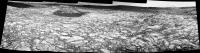
Midnight Planets reporting that Curiosity moved approximately 46.2m SSE (161º) on Sol 1172. LINK Quick and Dirty L-NavCam using the 5 available frames (MS ICE), reduced ~10% to get within the UL limit
|
|
 |
 
|
|
 |
|
Dec 2 2015, 12:14 PM
Post
#2
|
|
|
Senior Member Group: Members Posts: 2430 Joined: 30-January 13 From: Penang, Malaysia. Member No.: 6853 |
|
|
|
|
|
Dec 3 2015, 08:50 PM
Post
#3
|
|
|
Junior Member Group: Members Posts: 58 Joined: 9-April 15 Member No.: 7433 |
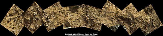
QUOTE (PaulH51 @ Dec 2 2015, 05:14 AM)  Sol 1173: L-MastCam, MS ICE, enhanced. All three RH side wheels and a mix of exposed bedrock and mini-ripples Awesome!!! Can you do for SOL 1176? There is an awesome disturbed area...I stitched together, but my skills really well, not the best. |
|
|
|
|
Dec 4 2015, 02:28 AM
Post
#4
|
|
|
Senior Member Group: Members Posts: 2430 Joined: 30-January 13 From: Penang, Malaysia. Member No.: 6853 |
QUOTE (Arizona Dave @ Dec 4 2015, 04:50 AM) ....Can you do for SOL 1176? There is an awesome disturbed area... Here is the 1176 L-MastCams in a mosaic (using MS ICE), sharpened and enhanced after stitching 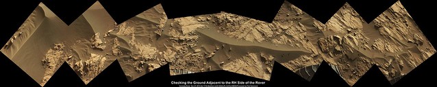 Flickr Original Size 9229 x 1852 pixels LINK Imgur LINK EDIT: Mission Update by Ken Herkenhoff - Sol 1183: Completing mobility tests. LINK QUOTE Today we are planning the last sol of the mobility test, turning and backing out of the sand while taking multiple Hazcam images, then pausing to take Navcam and Mastcam images of the wheel tracks. But first, Mastcam will take multispectral images of a rock named Narabeb and a soil target dubbed Kubib. The right Mastcam will also acquire another 2x2 mosaic of Secomib, to look for changes in the trench wall, and image the spots where the APXS was placed on the sand. The biggest challenge for me as SOWG Chair today was to prioritize the post-drive data, as the volume of data expected to be received in time for planning tomorrow is smaller than usual. Were hoping that the rover will drive close enough to High Dune to allow contact science on the dark dune sand, so well need good images of the arm workspace. But were also planning to drive again this weekend, so well also need images in the direction of the drive. It looks like we will get just enough data to enable a full weekend plan, assuming that all the orbiter and ground assets work as weve come to expect.
Later in the afternoon, the ChemCam RMI and right Mastcam will acquire a small mosaic of an outcrop up on Mount Sharp, and both Mastcams will image the ground in front of the rover. Finally, the left Mastcam will acquire a mosaic of the ground and sand to the right of the rover, and MARDI will take another twilight image. |
|
|
|
|
Dec 8 2015, 05:00 PM
Post
#5
|
|
|
Junior Member Group: Members Posts: 58 Joined: 9-April 15 Member No.: 7433 |
[quote name='PaulH51' date='Dec 3 2015, 07:28 PM' post='228302']
Here is the 1176 L-MastCams in a mosaic (using MS ICE), sharpened and enhanced after stitching Wow, really amazing...There are several very odd-interesting objects in the frame, in addition to the disrupted rock that looks like it "blew" up after being disturbed... Something that really catches my eye is smack-dab at the lower intersection of the right 2 frames, right where the 2 frames intersect at the top of the blacked out missing area...it literally looks like translucent ice-like "wavey" thin "something"... Also nee an interesting tube-clast sticking up in the far upper-left left-most frame. THANK YOU!!! |
|
|
|
|
Dec 8 2015, 09:46 PM
Post
#6
|
|
|
Member Group: Members Posts: 866 Joined: 15-March 05 From: Santa Cruz, CA Member No.: 196 |
QUOTE (Arizona Dave @ Dec 8 2015, 09:00 AM) ...Something that really catches my eye is smack-dab at the lower intersection of the right 2 frames, right where the 2 frames intersect at the top of the blacked out missing area...it literally looks like translucent ice-like "wavey" thin "something"... Do you mean the hovering rock arm above that distinct monkey-tail crack at the top of the big nudged rock centerframe in this frame? my eyes at first misinterpreted that shadow as a sort of smudge until i looked at it again later, or maybe its the bright exposed interior of the broken rock at bottom right of that image? unfortunately i wasnt able to locate the tube clast either.. |
|
|
|
 PaulH51 Exploring Mt Sharp - The Dunes - Part 1: Bagnold Dunes Nov 23 2015, 12:41 PM
 PaulH51 Mission Update from Lauren Edgar - Sol 1173: Dune ... Nov 23 2015, 10:54 PM charborob Sol 1172 Lmastcam view of the "mini-dustbowl... Nov 24 2015, 01:16 PM Phil Stooke Today's (sol 1173's) Hazcams reprojected t... Nov 24 2015, 02:40 PM jvandriel The Navcam L view on Sol 1172.
Jan van Driel
Nov 24 2015, 04:00 PM Phil Stooke A very nice view. Here it is projected into a cir... Nov 24 2015, 09:19 PM PaulH51 Sol 1173: L-NavCam (17 frames) Quick and Dirty in ... Nov 25 2015, 08:24 AM jvandriel The complete Navcam L view on Sol 1173.
Jan van D... Nov 25 2015, 11:01 AM Phil Stooke A quick hazcam reprojection to find the sol 1174 l... Nov 25 2015, 03:31 PM Herobrine NAVCAM travel animation for Sol 1172 is 47 frames.... Nov 25 2015, 04:05 PM atomoid stunning imagery from sol1173 m100s including some... Nov 25 2015, 09:34 PM PaulH51 Really interesting far off ripples, and great red/... Nov 26 2015, 12:04 AM Phil Stooke Damia Bouic has posted another panorama here:
htt... Nov 26 2015, 12:43 AM jvandriel Here is my view of the Sol 1174 Navcam L panorama.... Nov 26 2015, 10:06 AM PaulH51 sol 1173: 4 frames from the R-MastCam, MS ICE, som... Nov 26 2015, 12:33 PM neo56 My take on these recent panoramas of dunes and mou... Nov 26 2015, 09:08 PM
PaulH51 Mission Update from Lauren Edgar - Sol 1173: Dune ... Nov 23 2015, 10:54 PM charborob Sol 1172 Lmastcam view of the "mini-dustbowl... Nov 24 2015, 01:16 PM Phil Stooke Today's (sol 1173's) Hazcams reprojected t... Nov 24 2015, 02:40 PM jvandriel The Navcam L view on Sol 1172.
Jan van Driel
Nov 24 2015, 04:00 PM Phil Stooke A very nice view. Here it is projected into a cir... Nov 24 2015, 09:19 PM PaulH51 Sol 1173: L-NavCam (17 frames) Quick and Dirty in ... Nov 25 2015, 08:24 AM jvandriel The complete Navcam L view on Sol 1173.
Jan van D... Nov 25 2015, 11:01 AM Phil Stooke A quick hazcam reprojection to find the sol 1174 l... Nov 25 2015, 03:31 PM Herobrine NAVCAM travel animation for Sol 1172 is 47 frames.... Nov 25 2015, 04:05 PM atomoid stunning imagery from sol1173 m100s including some... Nov 25 2015, 09:34 PM PaulH51 Really interesting far off ripples, and great red/... Nov 26 2015, 12:04 AM Phil Stooke Damia Bouic has posted another panorama here:
htt... Nov 26 2015, 12:43 AM jvandriel Here is my view of the Sol 1174 Navcam L panorama.... Nov 26 2015, 10:06 AM PaulH51 sol 1173: 4 frames from the R-MastCam, MS ICE, som... Nov 26 2015, 12:33 PM neo56 My take on these recent panoramas of dunes and mou... Nov 26 2015, 09:08 PM
 PaulH51 QUOTE (neo56 @ Nov 27 2015, 05:08 AM) My ... Nov 27 2015, 12:50 AM neo56 Another view of the wall of Gale crater, this time... Nov 27 2015, 07:15 PM Herobrine Combined NAVCAM travel animation for Sols 1173-117... Nov 30 2015, 07:15 PM James Sorenson Here is a 3D DTM model that I generated using Navc... Nov 30 2015, 08:18 PM neo56 Two sections of the panorama taken with MC100 on s... Dec 1 2015, 08:08 PM PaulH51 Mission Update by Ken Herkenhoff - Sol 1181: Mobil... Dec 2 2015, 07:17 AM fredk Interesting hue variations on the dunes. Here I... Dec 2 2015, 02:57 PM Phil Stooke Reprojected Hazcam images show a little toe-dip in... Dec 2 2015, 07:14 PM James Sorenson A 3D DTM of one of the wheel tracks into the dune-... Dec 2 2015, 07:27 PM PaulH51 QUOTE (James Sorenson @ Dec 3 2015, 03:27... Dec 2 2015, 11:21 PM Phil Stooke http://www.midnightplanets.com/web/MSL/ima...CAM02... Dec 3 2015, 05:15 PM PaulH51 QUOTE (Phil Stooke @ Dec 4 2015, 01:15 AM... Dec 4 2015, 01:01 AM jccwrt Looks like on Sols 1174, 1176, and 1178, Curiosity... Dec 4 2015, 06:20 AM Arizona Dave QUOTE Here's the full size version with less c... Dec 8 2015, 05:21 PM serpens [quote name='Arizona Dave' date='Dec 8... Dec 10 2015, 10:07 PM Phil Stooke This reprojection of the sol 1183 hazcams lets me ... Dec 4 2015, 09:30 PM PaulH51 Sol 1181 RMI-ChemCam target shown in context on a ... Dec 5 2015, 03:30 AM James Sorenson A couple of Navcam and Front Hazcam DTM's at o... Dec 5 2015, 07:34 AM PaulH51 Sol 1182: Overlapping MAHLI's acquired at Dune... Dec 6 2015, 10:04 AM PaulH51 Sol 1185: Midnight Planets reports a drive ~31 met... Dec 7 2015, 11:30 AM jvandriel The Navcam L view on Sol 1185.
Jan van Driel
Dec 7 2015, 12:36 PM Phil Stooke Great! This is a circular version of it.
Phi... Dec 7 2015, 02:31 PM PaulH51 Context image for the MAHLI mosaic I posted here y... Dec 7 2015, 02:41 PM jccwrt Upper layer of sand might have a bit of grain inte... Dec 7 2015, 05:54 PM PaulH51 QUOTE (jccwrt @ Dec 8 2015, 01:54 AM) Upp... Dec 8 2015, 02:16 AM neo56 My take on this dramatic view of the base of Mount... Dec 7 2015, 06:39 PM neo56 My take on RMI-Chemcam mosaic colored with a MC100... Dec 8 2015, 08:08 AM eliBonora @PaulH51 useful context!
I'm really fasci... Dec 8 2015, 05:20 PM Arizona Dave QUOTE (eliBonora @ Dec 8 2015, 10:20 AM) ... Dec 8 2015, 05:24 PM MrNatural QUOTE (Arizona Dave @ Dec 8 2015, 05:24 P... Dec 8 2015, 06:34 PM Gerald QUOTE (MrNatural @ Dec 8 2015, 08:34 PM) ... Dec 9 2015, 06:53 PM PaulH51 QUOTE (eliBonora @ Dec 9 2015, 01:20 AM) ... Dec 9 2015, 01:00 PM Actionman fine pea gavel. Not likely to drift around in the ... Dec 9 2015, 09:30 PM PaulH51 Curiosity Rover Mission Update from Ken Herkenhoff... Dec 10 2015, 07:33 AM Floyd If the dunes are pea gravel, then can't we jus... Dec 11 2015, 12:28 AM serpens The definitions for pea gravel pretty much encompa... Dec 11 2015, 03:10 AM jvandriel The Navcam L Panorama on Sol 1187.
Jan van Driel
... Dec 11 2015, 03:34 PM Astro0 A non-Phil polar projection of Jan's pan.
Dec 12 2015, 01:30 AM Phil Stooke Humbug! I was too late to get mine up there f... Dec 12 2015, 04:10 AM PaulH51 Curiosity Rover Mission Update from ken Herkenhoff... Dec 12 2015, 06:35 AM PaulH51 Sol 1189: 6 frame L-MastCam mosaic
Flickr Origin... Dec 12 2015, 11:54 AM PaulH51 Curiosity has been imaged twice by HiRISE in Septe... Dec 13 2015, 04:11 AM PaulH51 Sol 1190: A small taste of the Namib Dune from the... Dec 13 2015, 06:19 AM PaulH51 Sol 1192: Rough and Ready (MS ICE) L-NavCam end-of... Dec 14 2015, 11:00 AM Phil Stooke Nice, Paul - here is a circular version of it, whi... Dec 14 2015, 01:59 PM PaulH51 QUOTE (Phil Stooke @ Dec 14 2015, 09:59 P... Dec 14 2015, 02:27 PM jvandriel and here is my view of the Sol 1192 Navcam L Panor... Dec 14 2015, 02:53 PM Herobrine NAVCAM stereo travel animation for Sol 1181 is 31 ... Dec 14 2015, 08:11 PM PaulH51 QUOTE (Herobrine @ Dec 15 2015, 04:11 AM)... Dec 15 2015, 03:18 AM PaulH51 Curiosity Rover Mission Update from Lauren Edgar -... Dec 15 2015, 12:52 PM PaulH51 Curiosity Rover Report from Bethany Ehlmann:
Fir... Dec 16 2015, 01:40 AM PaulH51 The Sol 1194 drive looks to have been completed as... Dec 16 2015, 06:40 AM Sean QUOTE (PaulH51 @ Dec 16 2015, 06:40 AM) T... Dec 16 2015, 03:45 PM Arizona Dave http://mars.jpl.nasa.gov/msl/multimedia/ra...72M_... Dec 16 2015, 06:20 PM fredk QUOTE (Arizona Dave @ Dec 16 2015, 07:20 ... Dec 16 2015, 07:10 PM Arizona Dave QUOTE (fredk @ Dec 16 2015, 12:10 PM) Whi... Dec 18 2015, 04:10 PM fredk QUOTE (Arizona Dave @ Dec 18 2015, 05:10 ... Dec 18 2015, 05:22 PM neo56 My take on this awesome view of Namib dune:
ADMIN... Dec 16 2015, 08:41 PM Sean QUOTE (neo56 @ Dec 16 2015, 08:41 PM) My ... Dec 17 2015, 03:02 AM atomoid Thanks for the nice stitches of what to me at leas... Dec 16 2015, 10:31 PM PaulH51 Curiosity Rover Mission Update by Lauren Edgar - S... Dec 17 2015, 04:30 AM PaulH51 Sol 1194: 3 of the 5 drive direction L-Mastcam fra... Dec 17 2015, 08:01 AM Explorer1 Wow, what an angle! Earth dunes can never get ... Dec 17 2015, 08:27 AM PaulH51 QUOTE (Explorer1 @ Dec 17 2015, 04:27 PM)... Dec 17 2015, 08:58 AM siravan QUOTE (Explorer1 @ Dec 17 2015, 03:27 AM)... Dec 17 2015, 03:03 PM Arizona Dave QUOTE (siravan @ Dec 17 2015, 08:03 AM) T... Dec 18 2015, 04:17 PM Gerald QUOTE (Arizona Dave @ Dec 18 2015, 06:17 ... Dec 18 2015, 06:19 PM nogal Here is a crop from MSL Traverse Map for Sol 1183.... Dec 17 2015, 01:25 PM Phil Stooke For a really steep slope, check this out:
http://... Dec 17 2015, 04:23 PM jvandriel The Navcam L view on Sol 1194.
Jan van Driel
Dec 17 2015, 09:11 PM PaulH51 JPL Press Release: Rocks Rich in Silica Present Pu... Dec 18 2015, 01:17 AM algorithm A low res Navcam anaglyph from Sol 1196 of the Nam... Dec 18 2015, 08:48 PM serpens The angle of repose for dunes on Mars should fall ... Dec 19 2015, 03:53 AM PaulH51 QUOTE (serpens @ Dec 19 2015, 11:53 AM) T... Dec 19 2015, 06:22 AM neo56 My take on the NavCam panorama of Namib dune on so... Dec 19 2015, 08:00 PM serpens Nicely done Neo. Dec 19 2015, 11:34 PM jvandriel The Navcam L view on Sol 1196.
Jan van Driel.
Dec 20 2015, 02:59 PM neo56 On sol 1197, Curiosity has made a full MC34 panora... Dec 20 2015, 03:36 PM
PaulH51 QUOTE (neo56 @ Nov 27 2015, 05:08 AM) My ... Nov 27 2015, 12:50 AM neo56 Another view of the wall of Gale crater, this time... Nov 27 2015, 07:15 PM Herobrine Combined NAVCAM travel animation for Sols 1173-117... Nov 30 2015, 07:15 PM James Sorenson Here is a 3D DTM model that I generated using Navc... Nov 30 2015, 08:18 PM neo56 Two sections of the panorama taken with MC100 on s... Dec 1 2015, 08:08 PM PaulH51 Mission Update by Ken Herkenhoff - Sol 1181: Mobil... Dec 2 2015, 07:17 AM fredk Interesting hue variations on the dunes. Here I... Dec 2 2015, 02:57 PM Phil Stooke Reprojected Hazcam images show a little toe-dip in... Dec 2 2015, 07:14 PM James Sorenson A 3D DTM of one of the wheel tracks into the dune-... Dec 2 2015, 07:27 PM PaulH51 QUOTE (James Sorenson @ Dec 3 2015, 03:27... Dec 2 2015, 11:21 PM Phil Stooke http://www.midnightplanets.com/web/MSL/ima...CAM02... Dec 3 2015, 05:15 PM PaulH51 QUOTE (Phil Stooke @ Dec 4 2015, 01:15 AM... Dec 4 2015, 01:01 AM jccwrt Looks like on Sols 1174, 1176, and 1178, Curiosity... Dec 4 2015, 06:20 AM Arizona Dave QUOTE Here's the full size version with less c... Dec 8 2015, 05:21 PM serpens [quote name='Arizona Dave' date='Dec 8... Dec 10 2015, 10:07 PM Phil Stooke This reprojection of the sol 1183 hazcams lets me ... Dec 4 2015, 09:30 PM PaulH51 Sol 1181 RMI-ChemCam target shown in context on a ... Dec 5 2015, 03:30 AM James Sorenson A couple of Navcam and Front Hazcam DTM's at o... Dec 5 2015, 07:34 AM PaulH51 Sol 1182: Overlapping MAHLI's acquired at Dune... Dec 6 2015, 10:04 AM PaulH51 Sol 1185: Midnight Planets reports a drive ~31 met... Dec 7 2015, 11:30 AM jvandriel The Navcam L view on Sol 1185.
Jan van Driel
Dec 7 2015, 12:36 PM Phil Stooke Great! This is a circular version of it.
Phi... Dec 7 2015, 02:31 PM PaulH51 Context image for the MAHLI mosaic I posted here y... Dec 7 2015, 02:41 PM jccwrt Upper layer of sand might have a bit of grain inte... Dec 7 2015, 05:54 PM PaulH51 QUOTE (jccwrt @ Dec 8 2015, 01:54 AM) Upp... Dec 8 2015, 02:16 AM neo56 My take on this dramatic view of the base of Mount... Dec 7 2015, 06:39 PM neo56 My take on RMI-Chemcam mosaic colored with a MC100... Dec 8 2015, 08:08 AM eliBonora @PaulH51 useful context!
I'm really fasci... Dec 8 2015, 05:20 PM Arizona Dave QUOTE (eliBonora @ Dec 8 2015, 10:20 AM) ... Dec 8 2015, 05:24 PM MrNatural QUOTE (Arizona Dave @ Dec 8 2015, 05:24 P... Dec 8 2015, 06:34 PM Gerald QUOTE (MrNatural @ Dec 8 2015, 08:34 PM) ... Dec 9 2015, 06:53 PM PaulH51 QUOTE (eliBonora @ Dec 9 2015, 01:20 AM) ... Dec 9 2015, 01:00 PM Actionman fine pea gavel. Not likely to drift around in the ... Dec 9 2015, 09:30 PM PaulH51 Curiosity Rover Mission Update from Ken Herkenhoff... Dec 10 2015, 07:33 AM Floyd If the dunes are pea gravel, then can't we jus... Dec 11 2015, 12:28 AM serpens The definitions for pea gravel pretty much encompa... Dec 11 2015, 03:10 AM jvandriel The Navcam L Panorama on Sol 1187.
Jan van Driel
... Dec 11 2015, 03:34 PM Astro0 A non-Phil polar projection of Jan's pan.
Dec 12 2015, 01:30 AM Phil Stooke Humbug! I was too late to get mine up there f... Dec 12 2015, 04:10 AM PaulH51 Curiosity Rover Mission Update from ken Herkenhoff... Dec 12 2015, 06:35 AM PaulH51 Sol 1189: 6 frame L-MastCam mosaic
Flickr Origin... Dec 12 2015, 11:54 AM PaulH51 Curiosity has been imaged twice by HiRISE in Septe... Dec 13 2015, 04:11 AM PaulH51 Sol 1190: A small taste of the Namib Dune from the... Dec 13 2015, 06:19 AM PaulH51 Sol 1192: Rough and Ready (MS ICE) L-NavCam end-of... Dec 14 2015, 11:00 AM Phil Stooke Nice, Paul - here is a circular version of it, whi... Dec 14 2015, 01:59 PM PaulH51 QUOTE (Phil Stooke @ Dec 14 2015, 09:59 P... Dec 14 2015, 02:27 PM jvandriel and here is my view of the Sol 1192 Navcam L Panor... Dec 14 2015, 02:53 PM Herobrine NAVCAM stereo travel animation for Sol 1181 is 31 ... Dec 14 2015, 08:11 PM PaulH51 QUOTE (Herobrine @ Dec 15 2015, 04:11 AM)... Dec 15 2015, 03:18 AM PaulH51 Curiosity Rover Mission Update from Lauren Edgar -... Dec 15 2015, 12:52 PM PaulH51 Curiosity Rover Report from Bethany Ehlmann:
Fir... Dec 16 2015, 01:40 AM PaulH51 The Sol 1194 drive looks to have been completed as... Dec 16 2015, 06:40 AM Sean QUOTE (PaulH51 @ Dec 16 2015, 06:40 AM) T... Dec 16 2015, 03:45 PM Arizona Dave http://mars.jpl.nasa.gov/msl/multimedia/ra...72M_... Dec 16 2015, 06:20 PM fredk QUOTE (Arizona Dave @ Dec 16 2015, 07:20 ... Dec 16 2015, 07:10 PM Arizona Dave QUOTE (fredk @ Dec 16 2015, 12:10 PM) Whi... Dec 18 2015, 04:10 PM fredk QUOTE (Arizona Dave @ Dec 18 2015, 05:10 ... Dec 18 2015, 05:22 PM neo56 My take on this awesome view of Namib dune:
ADMIN... Dec 16 2015, 08:41 PM Sean QUOTE (neo56 @ Dec 16 2015, 08:41 PM) My ... Dec 17 2015, 03:02 AM atomoid Thanks for the nice stitches of what to me at leas... Dec 16 2015, 10:31 PM PaulH51 Curiosity Rover Mission Update by Lauren Edgar - S... Dec 17 2015, 04:30 AM PaulH51 Sol 1194: 3 of the 5 drive direction L-Mastcam fra... Dec 17 2015, 08:01 AM Explorer1 Wow, what an angle! Earth dunes can never get ... Dec 17 2015, 08:27 AM PaulH51 QUOTE (Explorer1 @ Dec 17 2015, 04:27 PM)... Dec 17 2015, 08:58 AM siravan QUOTE (Explorer1 @ Dec 17 2015, 03:27 AM)... Dec 17 2015, 03:03 PM Arizona Dave QUOTE (siravan @ Dec 17 2015, 08:03 AM) T... Dec 18 2015, 04:17 PM Gerald QUOTE (Arizona Dave @ Dec 18 2015, 06:17 ... Dec 18 2015, 06:19 PM nogal Here is a crop from MSL Traverse Map for Sol 1183.... Dec 17 2015, 01:25 PM Phil Stooke For a really steep slope, check this out:
http://... Dec 17 2015, 04:23 PM jvandriel The Navcam L view on Sol 1194.
Jan van Driel
Dec 17 2015, 09:11 PM PaulH51 JPL Press Release: Rocks Rich in Silica Present Pu... Dec 18 2015, 01:17 AM algorithm A low res Navcam anaglyph from Sol 1196 of the Nam... Dec 18 2015, 08:48 PM serpens The angle of repose for dunes on Mars should fall ... Dec 19 2015, 03:53 AM PaulH51 QUOTE (serpens @ Dec 19 2015, 11:53 AM) T... Dec 19 2015, 06:22 AM neo56 My take on the NavCam panorama of Namib dune on so... Dec 19 2015, 08:00 PM serpens Nicely done Neo. Dec 19 2015, 11:34 PM jvandriel The Navcam L view on Sol 1196.
Jan van Driel.
Dec 20 2015, 02:59 PM neo56 On sol 1197, Curiosity has made a full MC34 panora... Dec 20 2015, 03:36 PM |

|
Lo-Fi Version | Time is now: 5th June 2024 - 04:48 AM |
|
RULES AND GUIDELINES Please read the Forum Rules and Guidelines before posting. IMAGE COPYRIGHT |
OPINIONS AND MODERATION Opinions expressed on UnmannedSpaceflight.com are those of the individual posters and do not necessarily reflect the opinions of UnmannedSpaceflight.com or The Planetary Society. The all-volunteer UnmannedSpaceflight.com moderation team is wholly independent of The Planetary Society. The Planetary Society has no influence over decisions made by the UnmannedSpaceflight.com moderators. |
SUPPORT THE FORUM Unmannedspaceflight.com is funded by the Planetary Society. Please consider supporting our work and many other projects by donating to the Society or becoming a member. |
|