
Chang'e 3 data |

Chang'e 3 data |
 Jan 29 2016, 03:58 PM Jan 29 2016, 03:58 PM
Post
#1
|
|
 Administrator  Group: Admin Posts: 5172 Joined: 4-August 05 From: Pasadena, CA, USA, Earth Member No.: 454 |
Chang'e 3 data is now available to the international community in PDS format through the Science and Application Center for Moon and Deepspace Exploration (China's version of the PDS). The website tends to be unstable; login has not worked for me all week...but it is working now. If you don't want to work through the website, I have downloaded and posted the entire available TCAM and PCAM data sets, with links and explanation in this blog entry. Have at it!
-------------------- My website - My Patreon - @elakdawalla on Twitter - Please support unmannedspaceflight.com by donating here.
|
 |
 
|
 |
|
Jan 30 2016, 01:29 AM
Post
#2
|
|
|
Member Group: Members Posts: 306 Joined: 4-October 14 Member No.: 7273 |
I've taken a stab at working with this data set using the demosaiced png images. Colorization was done using gmic's "bayer2rgb" routine, which for some reason spit these images out with the red channel significantly fainter than the green and blue channels. As a result I've kind of had to guess at how bright the red needs to be, so the color is probably off. I should probably grab some of the official releases to compare color.
Anyway I did some cleaning up in Photoshop (slight gaussian filter to remove the last traces of bayer patterning, a denoise filter to remove some of the color noise, and some sharpening to recover some of the detail lost with the bayer pattern removal) and here's the result: 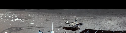 Chang'e 3 Observation 4 partial mosaic by Justin Cowart, on Flickr The problem I'm trying to tackle now is a slight color gradient between the left and right edges of the images. Although Photomerge does a good job handling overall brightness gradients, it's having a little more difficulty with the color. The neutral gray color of the terrain also makes slight variations in color stick out more. Here I've tried to reduce it with a bit of burning and dodging but I'm not entirely happy with the result. Once I get a better process down I'll probably rework this image, as well as assemble the full 360 degree panorama. |
|
|
|
 elakdawalla Chang'e 3 data Jan 29 2016, 03:58 PM
 Phil Stooke "Have at it!"
Oh, OK, if I must...
... Jan 29 2016, 05:54 PM elakdawalla I've had the same problem with the TCAM data -... Jan 30 2016, 01:34 AM Hungry4info I figured I would have a go at making some 3D anag... Jan 30 2016, 12:46 PM jccwrt Attempt #2 with the Observation 004 TCAM images. T... Jan 31 2016, 01:49 AM jccwrt Full panorama from Yutu Observation 008:
Mare Im... Feb 2 2016, 11:37 PM elakdawalla Beautiful!! Here it is on roundme: https:/... Feb 2 2016, 11:46 PM jccwrt Ask and you shall receive!
Dragon Rock An... Feb 4 2016, 01:07 AM elakdawalla I wonder if you'd have an easier time trying a... Feb 4 2016, 01:19 AM jccwrt Yeah, I'm going to try and take another shot w... Feb 4 2016, 01:50 AM machi Thanks Emily for great gallery of Chang'E 3 im... Feb 4 2016, 03:25 AM machi One of the test of workflow for TCAM data.
Full re... Feb 4 2016, 04:05 AM jccwrt QUOTE (machi @ Feb 3 2016, 09:25 PM) Than... Feb 5 2016, 01:25 AM Hungry4info Was the Chang'e 3 data release incomplete? I r... Feb 6 2016, 12:13 PM elakdawalla Quanzhi Ye told me that these images weren't r... Feb 6 2016, 02:58 PM Hungry4info I'm having trouble accessing this image taken ... Feb 20 2016, 07:33 PM
Phil Stooke "Have at it!"
Oh, OK, if I must...
... Jan 29 2016, 05:54 PM elakdawalla I've had the same problem with the TCAM data -... Jan 30 2016, 01:34 AM Hungry4info I figured I would have a go at making some 3D anag... Jan 30 2016, 12:46 PM jccwrt Attempt #2 with the Observation 004 TCAM images. T... Jan 31 2016, 01:49 AM jccwrt Full panorama from Yutu Observation 008:
Mare Im... Feb 2 2016, 11:37 PM elakdawalla Beautiful!! Here it is on roundme: https:/... Feb 2 2016, 11:46 PM jccwrt Ask and you shall receive!
Dragon Rock An... Feb 4 2016, 01:07 AM elakdawalla I wonder if you'd have an easier time trying a... Feb 4 2016, 01:19 AM jccwrt Yeah, I'm going to try and take another shot w... Feb 4 2016, 01:50 AM machi Thanks Emily for great gallery of Chang'E 3 im... Feb 4 2016, 03:25 AM machi One of the test of workflow for TCAM data.
Full re... Feb 4 2016, 04:05 AM jccwrt QUOTE (machi @ Feb 3 2016, 09:25 PM) Than... Feb 5 2016, 01:25 AM Hungry4info Was the Chang'e 3 data release incomplete? I r... Feb 6 2016, 12:13 PM elakdawalla Quanzhi Ye told me that these images weren't r... Feb 6 2016, 02:58 PM Hungry4info I'm having trouble accessing this image taken ... Feb 20 2016, 07:33 PM elakdawalla That is the highly informative error that you get ... Feb 20 2016, 08:17 PM
 |

|
Lo-Fi Version | Time is now: 15th June 2024 - 12:18 PM |
|
RULES AND GUIDELINES Please read the Forum Rules and Guidelines before posting. IMAGE COPYRIGHT |
OPINIONS AND MODERATION Opinions expressed on UnmannedSpaceflight.com are those of the individual posters and do not necessarily reflect the opinions of UnmannedSpaceflight.com or The Planetary Society. The all-volunteer UnmannedSpaceflight.com moderation team is wholly independent of The Planetary Society. The Planetary Society has no influence over decisions made by the UnmannedSpaceflight.com moderators. |
SUPPORT THE FORUM Unmannedspaceflight.com is funded by the Planetary Society. Please consider supporting our work and many other projects by donating to the Society or becoming a member. |
|


