Virtual Viking, Images and animations of the Viking landing sites |

Virtual Viking, Images and animations of the Viking landing sites |
 Sep 4 2008, 02:29 PM Sep 4 2008, 02:29 PM
Post
#101
|
||
|
Solar System Cartographer  Group: Members Posts: 10226 Joined: 5-April 05 From: Canada Member No.: 227 |
In the past we've had some good Viking images here. Soon - all too soon - we will not have Phoenix any more, but despair not! Now we can re-live Viking by playing with old images. They can be searched by sol at the PDS.
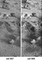
As an example, I've made a composite of the very last Surface Sampler activities at either Viking site. This is work done on Viking 2 sol 957 and imaged on sol 957 and 959. (someone can animate it if they like!) We see two separate trenching activities at the same place, and a soil dump (bottom) and a conical soil pile made by the second dump (middle). (more obvious in an animation, I just can't make one on this machine). Phil
-------------------- ... because the Solar System ain't gonna map itself.
Also to be found posting similar content on https://mastodon.social/@PhilStooke Maps for download (free PDF: https://upload.wikimedia.org/wikipedia/comm...Cartography.pdf NOTE: everything created by me which I post on UMSF is considered to be in the public domain (NOT CC, public domain) |
|
 |
 
|
|
 |
|
Jan 17 2016, 08:24 PM
Post
#102
|
|
 Senior Member Group: Members Posts: 1669 Joined: 5-March 05 From: Boulder, CO Member No.: 184 |
Nice to see Vanden's persistence and new result with the VL2 noon color hi-res panorama!
-------------------- Steve [ my home page and planetary maps page ]
|
|
|
|
|
Jan 29 2016, 01:46 AM
Post
#103
|
||
|
Junior Member Group: Members Posts: 22 Joined: 9-December 10 Member No.: 5551 |
Thanks !
I edited my post "NOON HIGH RESOLUTION COLOR MOSAIC" to add a new high resolution color image : 21i091_HIGH_RESOLUTION_COLOR Although modest in size it is a part of the famous/historical/mythical low-resolution color image (official version): PIA00571 For information here's how raw images (mainly used) are : - Low-resolution color: 21i093 - High-Resolution black & white : 21i091 My Low Resolution version (21i090+21i093+21d224-225-226) :
|
|
|
|
|
|
|
Jan 29 2016, 11:22 AM
Post
#104
|
|
 Senior Member Group: Members Posts: 1089 Joined: 19-February 05 From: Close to Meudon Observatory in France Member No.: 172 |
QUOTE (Vanden @ Jan 29 2016, 02:46 AM)  Thanks ! I edited my post "NOON HIGH RESOLUTION COLOR MOSAIC" to add a new high resolution color image : 21i091_HIGH_RESOLUTION_COLOR Although modest in size it is a part of the famous/historical/mythical low-resolution color image (official version): PIA00571 How nice Vanden ! Thanks a lot !  |
|
|
|
|
Feb 21 2016, 12:49 AM
Post
#105
|
|
|
Junior Member Group: Members Posts: 22 Joined: 9-December 10 Member No.: 5551 |
Viking Lander 2 Camera 2 Low Résolution FROST Color Images :
22i067 (Sol 955 12:13) 22i109 (Sol 1050 12:40 Panorama 22i103-104-105-109 (Sol 1028, 1030 and 1050 between 11:34 and 12:40) : 22i103-104-105-109 I used a low-resolution panorama of Oliver (thank) as a basis for color calibration. Viking Lander 2 Camera 2 Low Résolution SKY AT SUNRISE : 22b023 Sol 34 04:22 22h093 Sol 631 04:00 Viking Lander 1 Camera 2 Low Résolution SKY AT SUNRISE : 12e189 Sol379 07:50 |
|
|
|
|
Feb 22 2016, 09:09 AM
Post
#106
|
|||
|
Senior Member Group: Members Posts: 1089 Joined: 19-February 05 From: Close to Meudon Observatory in France Member No.: 172 |
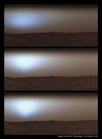
QUOTE (Vanden @ Feb 21 2016, 01:49 AM) Viking Lander 1 Camera 2 Low Résolution SKY AT SUNRISE Thanks a lot Vanden for those good processings of yours ! How NICE they are ! Your 'frost' pan is gorgeous The picture you show ('Low Resolution SKY AT SUNRISE') is a very interesting one indeed ! It is the 1st of three images taken more than ten minutes apart on Chryse Planitia by Viking Lander 1 on Sol 379 at 07:50 a.m, 08:03 a.m. and 08:15 a.m. respectively (see the 'triptych' herewith). The fog had settled in over the entire area and it was dense enough so that the Sun was not visible above the horizon until the last image where it made a shy appearance (elevations respectively of 0.0°, 2.7° and 5.4°). Like on Earth, sunrise on Mars often sees frost and patches of fog and low clouds made of water ice crystals. These images were the first direct, visible evidence of water exchange (moisture) between the Martian surface and its atmosphere. Sometimes, the cold nighttime temperatures lead to saturation of water vapor with fog formation that extends to altitudes of 60 m (97 feet) to 80 m (262 feet) above the surface during the night. Usually, the fog disperses within two hours after sunrise. 
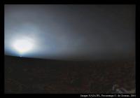
About your good idea of processing VL2's nice Sol 631 sunrise, here is the full story of this picture : the goal was then to capture the blue aureole of the Martian sky above the horizon. So, the Viking Lander Imaging Team members programmed camera # 2 to avoid imaging the Sun itself and the risk of damaging the delicate sensors. But, the timing of the sequence was calculated without enough margin. When the camera started to record the scene, the Sun was not yet visible. But when the mirror scanned the place where the Sun had to be, this one had just popped up over the horizon ! This small inaccuracy resulted in the making of one of the most iconic picture ever recorded by the Viking Landers : the first picture showing a sunrise on Mars. Please, note that the banding in the sky is an artifact produced by the subtle brightness levels that cannot be accurately captured by the camera imaging scan system. Also, some oblique delicate wispy markings in the sky crossing the aureole are thin cirrus clouds made of small water ice particles and believed to be drifting at an altitude of 10 to 15 km (6.20 to 9.30 miles) above the surface. This picture was the very first to capture Martian clouds from the surface. At the lower right of the picture, part of the Landers leg #3 support structure can be seen (herebelow here is my version)
|
||
|
|
|
||
|
Feb 22 2016, 12:07 PM
Post
#107
|
|
|
Junior Member Group: Members Posts: 22 Joined: 9-December 10 Member No.: 5551 |
Thank you for the information !
Small correction my Viking Lander 1 Camera 2 'Low Resolution SKY AT SUNRISE' 12E189 is the second of three images taken more than ten minutes apart on Chryse Planitia by Viking Lander 1 on Sol 379 at : 12E188 : 07:38 12E189 : 07:50 12E190 : 08:02 I have long wondered what is the white "spot" in the sky in 12e190 picture !!! In all first I thought is noise (the sun is not visible 12 minutes earlier) but it's too big and too concentrated for make this possible. I also thought the sun (see a star) but the sun should overexpose the sensor and should have been visible 12 minutes earlier ... But thanks to your explanation, all become more understandable ! Thank you ! Also thank you for your version of the 22H093 picture (and the explanation), I am inspired me to correct my version (minimization of overexposure in the blue and green channel). The link remains the same (see my previous post) |
|
|
|
 Phil Stooke Virtual Viking Sep 4 2008, 02:29 PM
 Phil Stooke Very nice, Olivier!
Phil Feb 24 2013, 06:57 PM vikingmars Thanks a lot Phil and Tom for your kind comments.
... Feb 24 2013, 09:37 PM Ant103 Ahhh, that's very nice Olivier ! Thanks f... Feb 24 2013, 11:53 PM vikingmars Many thanks Ant103.
...and here is the famous orig... Feb 25 2013, 10:15 AM tasp I think the value of that razor sharp pan is consi... Feb 25 2013, 02:40 PM vikingmars A frosty view of the Red Planet to wish you an Hap... Jan 1 2014, 06:18 PM Phil Stooke Thanks! It's nearly as cold as Mars here ... Jan 2 2014, 02:34 PM Glevesque Viking 1
Viking 2 Dec 2 2014, 05:51 PM
Phil Stooke Very nice, Olivier!
Phil Feb 24 2013, 06:57 PM vikingmars Thanks a lot Phil and Tom for your kind comments.
... Feb 24 2013, 09:37 PM Ant103 Ahhh, that's very nice Olivier ! Thanks f... Feb 24 2013, 11:53 PM vikingmars Many thanks Ant103.
...and here is the famous orig... Feb 25 2013, 10:15 AM tasp I think the value of that razor sharp pan is consi... Feb 25 2013, 02:40 PM vikingmars A frosty view of the Red Planet to wish you an Hap... Jan 1 2014, 06:18 PM Phil Stooke Thanks! It's nearly as cold as Mars here ... Jan 2 2014, 02:34 PM Glevesque Viking 1
Viking 2 Dec 2 2014, 05:51 PM
 4th rock from the sun I like your panorama site / book. I really hope yo... Dec 2 2014, 11:54 PM Glevesque Merci 4th rock from the sun,
J'ai les dates ... Dec 3 2014, 04:06 PM Phil Stooke This gives some Gas Exchange information:
http://... Dec 3 2014, 07:04 PM sittingduck Does anybody know where I could learn what the fin... Jan 15 2015, 12:51 PM Phil Stooke The sampler was last used on sol 958, and as far a... Jan 15 2015, 02:19 PM alex_k I processed five HiRise images of Viking 2 landing... Jan 18 2015, 04:02 PM alex_k Comparing with a model (found here):
Two cameras... Jan 20 2015, 03:51 PM RachelVL3 Phil and others interested in Viking, we are (slow... Nov 1 2015, 04:34 PM JohnVV for those using "No-script"
h t t p : / ... Nov 1 2015, 07:07 PM RachelVL3 QUOTE (JohnVV @ Nov 1 2015, 11:07 AM) for... Nov 1 2015, 08:18 PM vikingmars QUOTE (RachelVL3 @ Nov 1 2015, 09:18 PM) ... Nov 2 2015, 02:36 PM Vanden Happy New Year !
In the beginning of 2016 I s... Jan 12 2016, 03:18 PM vikingmars QUOTE (Vanden @ Jan 12 2016, 04:18 PM) Ha... Jan 13 2016, 12:14 PM Vanden I add links to all high-resolution color images :
... Jan 12 2016, 10:33 PM vikingmars QUOTE (Vanden @ Feb 22 2016, 01:07 PM) Al... Feb 22 2016, 03:28 PM Vanden Panorama Viking Lander 2 Camera 2 in native High r... Mar 2 2016, 01:48 AM Vanden I made a nice HTML5 animation that shows the diffe... Mar 5 2016, 12:10 AM Vanden Hello,
I made a website to present my images: htt... Apr 11 2016, 08:37 PM Phil Stooke Hi - do you mean the polar projections themselves ... May 1 2021, 08:11 PM Antdoghalo Polar mapped on top of the HiRISE base. May 1 2021, 08:30 PM Phil Stooke OK, I am posting four images illustrating this map... May 5 2021, 10:47 PM Phil Stooke OK... over 2 posts - the first two were combined i... May 5 2021, 10:54 PM Antdoghalo That is epic! You have a lot of skill doing th... May 6 2021, 04:23 PM Phil Stooke Hi - it should be easy to crop each one as needed.... May 6 2021, 06:01 PM Antdoghalo I cropped them (Viking 1) May 8 2021, 02:55 AM Antdoghalo Viking 2 May 8 2021, 03:21 AM Phil Stooke At Antdoghalo's request I will post maps like ... May 13 2021, 02:22 AM Glevesque Hi Phil, do you have a link for the topic 'Mar... Jun 25 2023, 02:43 PM Tom Tamlyn I suspect that Phil means this:
Unmanned Spaceflig... Jun 25 2023, 03:42 PM
4th rock from the sun I like your panorama site / book. I really hope yo... Dec 2 2014, 11:54 PM Glevesque Merci 4th rock from the sun,
J'ai les dates ... Dec 3 2014, 04:06 PM Phil Stooke This gives some Gas Exchange information:
http://... Dec 3 2014, 07:04 PM sittingduck Does anybody know where I could learn what the fin... Jan 15 2015, 12:51 PM Phil Stooke The sampler was last used on sol 958, and as far a... Jan 15 2015, 02:19 PM alex_k I processed five HiRise images of Viking 2 landing... Jan 18 2015, 04:02 PM alex_k Comparing with a model (found here):
Two cameras... Jan 20 2015, 03:51 PM RachelVL3 Phil and others interested in Viking, we are (slow... Nov 1 2015, 04:34 PM JohnVV for those using "No-script"
h t t p : / ... Nov 1 2015, 07:07 PM RachelVL3 QUOTE (JohnVV @ Nov 1 2015, 11:07 AM) for... Nov 1 2015, 08:18 PM vikingmars QUOTE (RachelVL3 @ Nov 1 2015, 09:18 PM) ... Nov 2 2015, 02:36 PM Vanden Happy New Year !
In the beginning of 2016 I s... Jan 12 2016, 03:18 PM vikingmars QUOTE (Vanden @ Jan 12 2016, 04:18 PM) Ha... Jan 13 2016, 12:14 PM Vanden I add links to all high-resolution color images :
... Jan 12 2016, 10:33 PM vikingmars QUOTE (Vanden @ Feb 22 2016, 01:07 PM) Al... Feb 22 2016, 03:28 PM Vanden Panorama Viking Lander 2 Camera 2 in native High r... Mar 2 2016, 01:48 AM Vanden I made a nice HTML5 animation that shows the diffe... Mar 5 2016, 12:10 AM Vanden Hello,
I made a website to present my images: htt... Apr 11 2016, 08:37 PM Phil Stooke Hi - do you mean the polar projections themselves ... May 1 2021, 08:11 PM Antdoghalo Polar mapped on top of the HiRISE base. May 1 2021, 08:30 PM Phil Stooke OK, I am posting four images illustrating this map... May 5 2021, 10:47 PM Phil Stooke OK... over 2 posts - the first two were combined i... May 5 2021, 10:54 PM Antdoghalo That is epic! You have a lot of skill doing th... May 6 2021, 04:23 PM Phil Stooke Hi - it should be easy to crop each one as needed.... May 6 2021, 06:01 PM Antdoghalo I cropped them (Viking 1) May 8 2021, 02:55 AM Antdoghalo Viking 2 May 8 2021, 03:21 AM Phil Stooke At Antdoghalo's request I will post maps like ... May 13 2021, 02:22 AM Glevesque Hi Phil, do you have a link for the topic 'Mar... Jun 25 2023, 02:43 PM Tom Tamlyn I suspect that Phil means this:
Unmanned Spaceflig... Jun 25 2023, 03:42 PM |

|
Lo-Fi Version | Time is now: 21st September 2024 - 06:45 PM |
|
RULES AND GUIDELINES Please read the Forum Rules and Guidelines before posting. IMAGE COPYRIGHT |
OPINIONS AND MODERATION Opinions expressed on UnmannedSpaceflight.com are those of the individual posters and do not necessarily reflect the opinions of UnmannedSpaceflight.com or The Planetary Society. The all-volunteer UnmannedSpaceflight.com moderation team is wholly independent of The Planetary Society. The Planetary Society has no influence over decisions made by the UnmannedSpaceflight.com moderators. |
SUPPORT THE FORUM Unmannedspaceflight.com is funded by the Planetary Society. Please consider supporting our work and many other projects by donating to the Society or becoming a member. |
|