Ceres Low-Altitude Mapping Orbit (LAMO) |

Ceres Low-Altitude Mapping Orbit (LAMO) |
 Dec 22 2015, 04:50 PM Dec 22 2015, 04:50 PM
Post
#31
|
|
|
Senior Member  Group: Members Posts: 3008 Joined: 30-October 04 Member No.: 105 |
-------------------- |
 |
 
|
 |
|
Mar 8 2016, 06:50 AM
Post
#32
|
|
|
Member Group: Members Posts: 890 Joined: 18-November 08 Member No.: 4489 |
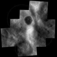
for lamo "PIA20348"
this is what i get in Blender 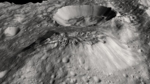 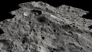 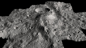 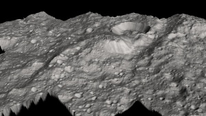 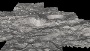 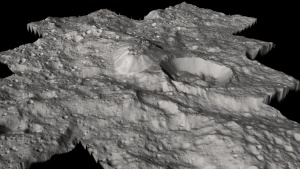 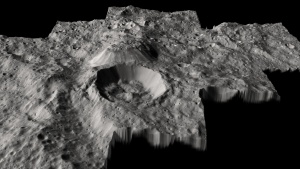 and a 8bit copy of the heightmap 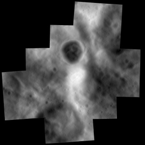
|
|
|
|
|
Mar 10 2016, 08:30 PM
Post
#33
|
||
|
Junior Member Group: Members Posts: 48 Joined: 20-December 14 Member No.: 7370 |
QUOTE (JohnVV @ Mar 7 2016, 10:50 PM)  for lamo "PIA20348" this is what i get in Blender ... and a 8bit copy of the heightmap Nice renders, I think the height map is most telling - I sketched a few craters outllnes in dotted outlines. I think the upwelling of the mountain is part of the larger upwelling area (in solid outline), and because of the relatively fluffy old crater infill to the top left, it broke through at that spot. I still think the only thing that can get that kind of energy to build a plateau is an impact on the other side (Dantu) and this is the antipode. The age of the two events also seems roughly similar (newish events) P.S. Dawn just won the 2015 Collier Trophy - congrats to the team - thats a big deal! naa.aero/awards/awards-and-trophies/collier-trophy
|
|
|
|
|
|
 Bill Harris Ceres Low-Altitude Mapping Orbit (LAMO) Dec 22 2015, 04:50 PM
 Habukaz QUOTE Re: spots: I'm taking pics of small part... Jan 27 2016, 01:21 PM Bill Harris My idea is that the really good LAMO images are sp... Jan 27 2016, 03:26 PM ZLD My blog post
LAMO 14 Jan 27 2016, 05:12 PM Gladstoner QUOTE (ZLD @ Jan 27 2016, 03:29 AM) I def... Jan 27 2016, 08:48 PM Daniele_bianchino_Italy I think it is a central peak, some as seen on the ... Jan 28 2016, 01:15 AM
Habukaz QUOTE Re: spots: I'm taking pics of small part... Jan 27 2016, 01:21 PM Bill Harris My idea is that the really good LAMO images are sp... Jan 27 2016, 03:26 PM ZLD My blog post
LAMO 14 Jan 27 2016, 05:12 PM Gladstoner QUOTE (ZLD @ Jan 27 2016, 03:29 AM) I def... Jan 27 2016, 08:48 PM Daniele_bianchino_Italy I think it is a central peak, some as seen on the ... Jan 28 2016, 01:15 AM
 Gladstoner QUOTE (Daniele_bianchino_Italy @ Jan 27 2016,... Jan 28 2016, 02:15 AM JohnVV low angle renderings of that "volcano?"
... Jan 28 2016, 01:35 AM ZLD LAMO 15
My blog post Jan 28 2016, 09:24 PM Michael Capobianco Finally, a look into Kerwan, the sand dollar. Jan 28 2016, 11:25 PM Gladstoner Looks like a mini Haulani:
Jan 29 2016, 07:56 AM ZLD I didn't get to watch all of the SBAG Dawn pre... Jan 29 2016, 06:07 PM ZLD LAMO 16
My blog post Jan 29 2016, 07:23 PM ZLD LAMO 17
My blog post Feb 1 2016, 11:16 PM JohnVV A few low angle renders from LAMO 16
http://photo... Feb 2 2016, 02:55 AM ZLD LAMO 18
My blog post Feb 2 2016, 07:21 PM JohnVV lamo 18 - PIA20308
low angle illumination like th... Feb 3 2016, 02:16 AM ZLD LAMO 19
My blog post Feb 3 2016, 07:16 PM ZLD LAMO 20
My blog post Feb 4 2016, 07:03 PM ZLD LAMO 21
My blog post Feb 5 2016, 06:45 PM Habukaz Aaand....we got Occator*
* its western rim Feb 8 2016, 05:29 PM ZLD LAMO 22
My blog post Feb 8 2016, 08:02 PM JohnVV LAMO-22 -- PIA20312
a few renders -- less impres... Feb 9 2016, 02:13 AM PDP8E John, its very impressive! Feb 10 2016, 12:12 AM ZLD LAMO 23
Blog post Feb 10 2016, 05:51 AM ZLD LAMO 24
Blog post Feb 10 2016, 05:43 PM ZLD LAMO 25
Blog post Feb 11 2016, 05:58 PM JohnVV LAMO 26 - PIA20380
http://dawn.jpl.nasa.gov/multim... Feb 13 2016, 06:14 AM ZLD LAMO 26
My blog post Feb 13 2016, 05:07 PM ZLD LAMO 27
My blog post Feb 16 2016, 07:09 PM JohnVV and the renders in Blender that go along with LAM... Feb 16 2016, 09:08 PM ZLD I feel like I hadn't seen some of those John. ... Feb 17 2016, 01:38 AM ZLD LAMO 28
My blog post Feb 17 2016, 06:47 PM JohnVV QUOTE I feel like I hadn't seen some of those ... Feb 17 2016, 07:27 PM Ken2 Here's a quick gif of HAMO vs LAMO. I didn... Feb 17 2016, 08:41 PM Bill Harris Comparison of the recent LAMO LO-28 image with an ... Feb 18 2016, 01:52 PM ZLD LAMO 29
My blog post Feb 18 2016, 06:07 PM ZLD LAMO 30
My blog post Feb 19 2016, 05:51 PM JohnVV Lamo 30 - PIA20384 Feb 20 2016, 03:32 AM Bill Harris Created a new Ceres Gallery today and moved images... Feb 20 2016, 03:57 PM ZLD LAMO 31
My blog post Feb 22 2016, 07:36 PM Habukaz The latest image is quite the oblique beauty. I ho... Feb 23 2016, 05:32 PM ZLD LAMO 32
My blog post
Also, reoriented view o... Feb 23 2016, 06:05 PM ZLD Juling Crater synthetic animation. This transition... Feb 24 2016, 07:47 PM ZLD LAMO 33
My blog post
Also, another orientati... Feb 25 2016, 03:35 AM ZLD LAMO 34
My blog post
L29-L34 Feb 25 2016, 10:03 PM Gladstoner Dantu Crater mosaic:
(PIA20193, PIA20300, PIA2030... Feb 27 2016, 09:49 AM alan The bright streaks on the crater walls, landslides... Feb 27 2016, 08:32 PM Gladstoner QUOTE (alan @ Feb 27 2016, 02:32 PM) The ... Feb 27 2016, 10:41 PM ZLD LAMO 35
My blog post Feb 27 2016, 08:41 PM JohnVV a few renders of LAMO-35 PIA20389
in part... Feb 27 2016, 09:57 PM dvandorn Considering the extensive emplacement of impact de... Feb 28 2016, 03:20 PM ngunn QUOTE (dvandorn @ Feb 28 2016, 03:20 PM) ... Feb 28 2016, 09:17 PM ZLD I can't recall what conference was going on la... Feb 29 2016, 12:33 AM tanjent If there are deposits of white salty material embe... Feb 29 2016, 04:02 PM ZLD LAMO 36
My blog post Mar 1 2016, 03:38 PM Bill Harris Recent LAMO imagery and a current LAMO Index map:
... Mar 1 2016, 04:34 PM ZLD LAMO 37
My blog post Mar 1 2016, 05:50 PM JohnVV LAMO -36 (PIA20390)
is a very low angle of illumi... Mar 2 2016, 07:23 PM ZLD LAMO 38
My Blog Post
-----
LAMO 39
My Blog... Mar 4 2016, 05:23 AM charborob LAMO 39-40 mosaic:
Mar 4 2016, 08:49 PM Gladstoner QUOTE (charborob @ Mar 4 2016, 02:49 PM) ... Mar 5 2016, 06:02 PM ZLD LAMO 40
My Blog Post Mar 4 2016, 10:04 PM ZLD Was certainly thinking that as well Gladstoner. Th... Mar 5 2016, 07:38 PM Gladstoner A checklist of interesting features in Ikapati Cra... Mar 6 2016, 07:55 AM Bill Harris Ahuna. The closer we look, the more mysterious i... Mar 7 2016, 06:09 PM Explorer1 How large is the gap between the rim of the crater... Mar 7 2016, 07:01 PM Gladstoner That terrain on top of Ahuna.... It just seems to ... Mar 7 2016, 09:04 PM HSchirmer QUOTE (Gladstoner @ Mar 7 2016, 09:04 PM)... Mar 10 2016, 09:50 PM Bill Harris QUOTE (HSchirmer @ Mar 10 2016, 04:50 PM)... Mar 11 2016, 04:39 AM ZLD LAMO 41
My Blog Post
-----
Ahuna Mons in LA... Mar 7 2016, 10:56 PM Bill Harris QUOTE (Gladstoner)That terrain on top of Ahuna....... Mar 8 2016, 12:17 AM Bill Harris Added the new LAMO image of Acuna Mons to the SO-H... Mar 9 2016, 03:06 AM ZLD LAMO 42
My Blog Post Mar 10 2016, 03:53 PM ZLD LAMO 43
My Blog Post Mar 10 2016, 04:26 PM atomoid Rough crosseye/anaglyph incorporating HAMO/LAMO (P... Mar 10 2016, 10:21 PM JohnVV A few close-ups of the mount -- rotating around it Mar 11 2016, 05:39 AM Gladstoner Color-coded elevation map of Ahuna Mons:
http://p... Mar 11 2016, 10:20 PM TheAnt QUOTE (Gladstoner @ Mar 11 2016, 11:20 PM... Mar 13 2016, 04:04 PM Bill Harris I've looked at the topography and general stru... Mar 14 2016, 06:09 PM ZLD LAMO 44
My Blog Post Mar 15 2016, 01:56 PM ZLD LAMO 45
My Blog Post Mar 15 2016, 03:20 PM dvandorn QUOTE (ZLD @ Mar 15 2016, 10:20 AM) LAMO ... Mar 15 2016, 05:09 PM ZLD Yeah, that dot is the correct scale - 2 pixels is ... Mar 15 2016, 06:15 PM Explorer1 It's a hallmark of that low surface gravity of... Mar 15 2016, 06:36 PM ZLD LAMO 46
My Blog Post
I'm not going to... Mar 15 2016, 06:49 PM dvandorn In re LAMO 45 again, not only do we see boulders u... Mar 15 2016, 08:32 PM volcanopele I wonder if that might be due to a difference in t... Mar 15 2016, 09:32 PM Bill Harris There are so many oddities of these impact "e... Mar 16 2016, 02:13 AM charborob Mosaic of LAMO 39-40-49 images (Ikapati crater):
Mar 18 2016, 07:37 PM Steve5304 when do we see Spot 5. I can't wait at that so... Mar 18 2016, 08:43 PM JohnVV a few images from lamo 49 Mar 19 2016, 01:28 AM Phil Stooke Hot from LPSC - we were shown a well-exposed image... Mar 21 2016, 03:58 PM Explorer1 Low res pic from someone in the room (for those wh... Mar 21 2016, 04:16 PM peter59 QUOTE (Explorer1 @ Mar 21 2016, 05:16 PM)... Mar 22 2016, 05:26 PM JohnVV a few from LAMO 50
i am running into the ... Mar 22 2016, 04:12 AM charborob Among today's image release is a large mosaic ... Mar 22 2016, 05:25 PM Habukaz So, basically, there's a bright white mountain... Mar 22 2016, 05:50 PM
Gladstoner QUOTE (Daniele_bianchino_Italy @ Jan 27 2016,... Jan 28 2016, 02:15 AM JohnVV low angle renderings of that "volcano?"
... Jan 28 2016, 01:35 AM ZLD LAMO 15
My blog post Jan 28 2016, 09:24 PM Michael Capobianco Finally, a look into Kerwan, the sand dollar. Jan 28 2016, 11:25 PM Gladstoner Looks like a mini Haulani:
Jan 29 2016, 07:56 AM ZLD I didn't get to watch all of the SBAG Dawn pre... Jan 29 2016, 06:07 PM ZLD LAMO 16
My blog post Jan 29 2016, 07:23 PM ZLD LAMO 17
My blog post Feb 1 2016, 11:16 PM JohnVV A few low angle renders from LAMO 16
http://photo... Feb 2 2016, 02:55 AM ZLD LAMO 18
My blog post Feb 2 2016, 07:21 PM JohnVV lamo 18 - PIA20308
low angle illumination like th... Feb 3 2016, 02:16 AM ZLD LAMO 19
My blog post Feb 3 2016, 07:16 PM ZLD LAMO 20
My blog post Feb 4 2016, 07:03 PM ZLD LAMO 21
My blog post Feb 5 2016, 06:45 PM Habukaz Aaand....we got Occator*
* its western rim Feb 8 2016, 05:29 PM ZLD LAMO 22
My blog post Feb 8 2016, 08:02 PM JohnVV LAMO-22 -- PIA20312
a few renders -- less impres... Feb 9 2016, 02:13 AM PDP8E John, its very impressive! Feb 10 2016, 12:12 AM ZLD LAMO 23
Blog post Feb 10 2016, 05:51 AM ZLD LAMO 24
Blog post Feb 10 2016, 05:43 PM ZLD LAMO 25
Blog post Feb 11 2016, 05:58 PM JohnVV LAMO 26 - PIA20380
http://dawn.jpl.nasa.gov/multim... Feb 13 2016, 06:14 AM ZLD LAMO 26
My blog post Feb 13 2016, 05:07 PM ZLD LAMO 27
My blog post Feb 16 2016, 07:09 PM JohnVV and the renders in Blender that go along with LAM... Feb 16 2016, 09:08 PM ZLD I feel like I hadn't seen some of those John. ... Feb 17 2016, 01:38 AM ZLD LAMO 28
My blog post Feb 17 2016, 06:47 PM JohnVV QUOTE I feel like I hadn't seen some of those ... Feb 17 2016, 07:27 PM Ken2 Here's a quick gif of HAMO vs LAMO. I didn... Feb 17 2016, 08:41 PM Bill Harris Comparison of the recent LAMO LO-28 image with an ... Feb 18 2016, 01:52 PM ZLD LAMO 29
My blog post Feb 18 2016, 06:07 PM ZLD LAMO 30
My blog post Feb 19 2016, 05:51 PM JohnVV Lamo 30 - PIA20384 Feb 20 2016, 03:32 AM Bill Harris Created a new Ceres Gallery today and moved images... Feb 20 2016, 03:57 PM ZLD LAMO 31
My blog post Feb 22 2016, 07:36 PM Habukaz The latest image is quite the oblique beauty. I ho... Feb 23 2016, 05:32 PM ZLD LAMO 32
My blog post
Also, reoriented view o... Feb 23 2016, 06:05 PM ZLD Juling Crater synthetic animation. This transition... Feb 24 2016, 07:47 PM ZLD LAMO 33
My blog post
Also, another orientati... Feb 25 2016, 03:35 AM ZLD LAMO 34
My blog post
L29-L34 Feb 25 2016, 10:03 PM Gladstoner Dantu Crater mosaic:
(PIA20193, PIA20300, PIA2030... Feb 27 2016, 09:49 AM alan The bright streaks on the crater walls, landslides... Feb 27 2016, 08:32 PM Gladstoner QUOTE (alan @ Feb 27 2016, 02:32 PM) The ... Feb 27 2016, 10:41 PM ZLD LAMO 35
My blog post Feb 27 2016, 08:41 PM JohnVV a few renders of LAMO-35 PIA20389
in part... Feb 27 2016, 09:57 PM dvandorn Considering the extensive emplacement of impact de... Feb 28 2016, 03:20 PM ngunn QUOTE (dvandorn @ Feb 28 2016, 03:20 PM) ... Feb 28 2016, 09:17 PM ZLD I can't recall what conference was going on la... Feb 29 2016, 12:33 AM tanjent If there are deposits of white salty material embe... Feb 29 2016, 04:02 PM ZLD LAMO 36
My blog post Mar 1 2016, 03:38 PM Bill Harris Recent LAMO imagery and a current LAMO Index map:
... Mar 1 2016, 04:34 PM ZLD LAMO 37
My blog post Mar 1 2016, 05:50 PM JohnVV LAMO -36 (PIA20390)
is a very low angle of illumi... Mar 2 2016, 07:23 PM ZLD LAMO 38
My Blog Post
-----
LAMO 39
My Blog... Mar 4 2016, 05:23 AM charborob LAMO 39-40 mosaic:
Mar 4 2016, 08:49 PM Gladstoner QUOTE (charborob @ Mar 4 2016, 02:49 PM) ... Mar 5 2016, 06:02 PM ZLD LAMO 40
My Blog Post Mar 4 2016, 10:04 PM ZLD Was certainly thinking that as well Gladstoner. Th... Mar 5 2016, 07:38 PM Gladstoner A checklist of interesting features in Ikapati Cra... Mar 6 2016, 07:55 AM Bill Harris Ahuna. The closer we look, the more mysterious i... Mar 7 2016, 06:09 PM Explorer1 How large is the gap between the rim of the crater... Mar 7 2016, 07:01 PM Gladstoner That terrain on top of Ahuna.... It just seems to ... Mar 7 2016, 09:04 PM HSchirmer QUOTE (Gladstoner @ Mar 7 2016, 09:04 PM)... Mar 10 2016, 09:50 PM Bill Harris QUOTE (HSchirmer @ Mar 10 2016, 04:50 PM)... Mar 11 2016, 04:39 AM ZLD LAMO 41
My Blog Post
-----
Ahuna Mons in LA... Mar 7 2016, 10:56 PM Bill Harris QUOTE (Gladstoner)That terrain on top of Ahuna....... Mar 8 2016, 12:17 AM Bill Harris Added the new LAMO image of Acuna Mons to the SO-H... Mar 9 2016, 03:06 AM ZLD LAMO 42
My Blog Post Mar 10 2016, 03:53 PM ZLD LAMO 43
My Blog Post Mar 10 2016, 04:26 PM atomoid Rough crosseye/anaglyph incorporating HAMO/LAMO (P... Mar 10 2016, 10:21 PM JohnVV A few close-ups of the mount -- rotating around it Mar 11 2016, 05:39 AM Gladstoner Color-coded elevation map of Ahuna Mons:
http://p... Mar 11 2016, 10:20 PM TheAnt QUOTE (Gladstoner @ Mar 11 2016, 11:20 PM... Mar 13 2016, 04:04 PM Bill Harris I've looked at the topography and general stru... Mar 14 2016, 06:09 PM ZLD LAMO 44
My Blog Post Mar 15 2016, 01:56 PM ZLD LAMO 45
My Blog Post Mar 15 2016, 03:20 PM dvandorn QUOTE (ZLD @ Mar 15 2016, 10:20 AM) LAMO ... Mar 15 2016, 05:09 PM ZLD Yeah, that dot is the correct scale - 2 pixels is ... Mar 15 2016, 06:15 PM Explorer1 It's a hallmark of that low surface gravity of... Mar 15 2016, 06:36 PM ZLD LAMO 46
My Blog Post
I'm not going to... Mar 15 2016, 06:49 PM dvandorn In re LAMO 45 again, not only do we see boulders u... Mar 15 2016, 08:32 PM volcanopele I wonder if that might be due to a difference in t... Mar 15 2016, 09:32 PM Bill Harris There are so many oddities of these impact "e... Mar 16 2016, 02:13 AM charborob Mosaic of LAMO 39-40-49 images (Ikapati crater):
Mar 18 2016, 07:37 PM Steve5304 when do we see Spot 5. I can't wait at that so... Mar 18 2016, 08:43 PM JohnVV a few images from lamo 49 Mar 19 2016, 01:28 AM Phil Stooke Hot from LPSC - we were shown a well-exposed image... Mar 21 2016, 03:58 PM Explorer1 Low res pic from someone in the room (for those wh... Mar 21 2016, 04:16 PM peter59 QUOTE (Explorer1 @ Mar 21 2016, 05:16 PM)... Mar 22 2016, 05:26 PM JohnVV a few from LAMO 50
i am running into the ... Mar 22 2016, 04:12 AM charborob Among today's image release is a large mosaic ... Mar 22 2016, 05:25 PM Habukaz So, basically, there's a bright white mountain... Mar 22 2016, 05:50 PM |

|
Lo-Fi Version | Time is now: 23rd September 2024 - 11:06 AM |
|
RULES AND GUIDELINES Please read the Forum Rules and Guidelines before posting. IMAGE COPYRIGHT |
OPINIONS AND MODERATION Opinions expressed on UnmannedSpaceflight.com are those of the individual posters and do not necessarily reflect the opinions of UnmannedSpaceflight.com or The Planetary Society. The all-volunteer UnmannedSpaceflight.com moderation team is wholly independent of The Planetary Society. The Planetary Society has no influence over decisions made by the UnmannedSpaceflight.com moderators. |
SUPPORT THE FORUM Unmannedspaceflight.com is funded by the Planetary Society. Please consider supporting our work and many other projects by donating to the Society or becoming a member. |
|