MSL Images & Cameras, technical discussions of images, image processing and cameras |

MSL Images & Cameras, technical discussions of images, image processing and cameras |
 Aug 16 2012, 11:05 PM Aug 16 2012, 11:05 PM
Post
#511
|
||
 Senior Member  Group: Members Posts: 2228 Joined: 1-December 04 From: Marble Falls, Texas, USA Member No.: 116 |
I'm still trying to figure out a number of things about the new images we are trying to work with. Assuming others are likewise trying to learn, I thought I would open this thread to create a place for such discussions.
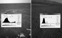
I'd like to start out with a comment about raw image contrast. There have been several postings in the main threads about whether or not the MSL raw images have been stretched like those from the MER missions. I am certainly no expert on this, but it looks to me as if the MSL images have not been stretched at all. I haven't tried to analyze all of the image types, but the hazcams and navcams have pixel brightness histograms that are very different from their MER counterparts. This attached image compares MER and MSL navcams along with their luminosity histograms.
The MSL images clearly are not using the entire, available range of brightness values, whereas the MER raws do. For this reason, the MSL raw images can usually be nicely enhanced by simply stretching the distribution of brightness across the full 256 value range. -------------------- ...Tom
I'm not a Space Fan, I'm a Space Exploration Enthusiast. |
|
 |
 
|
|
 |
|
Apr 21 2016, 08:11 PM
Post
#512
|
|
 Member Group: Members Posts: 244 Joined: 2-March 15 Member No.: 7408 |
QUOTE (mcaplinger @ Apr 20 2016, 03:45 PM)  If you're happy I'm happy, but it seems like an awful lot of work for something with not a lot of practical utility to me. I'm mostly interested in it for the prospect of removing some of the effects of the lighting conditions that existed when the image was acquired. I'm doing work with generating a color, 3-D environment from mountains of MSL data. I'd like to be able to light the scene myself so I can change the time of day, rather than being stuck with the lighting conditions that existed at the time an image was acquired, conditions that will not be consistent when combining data from different times. QUOTE (mcaplinger @ Apr 20 2016, 03:45 PM) And there are all kinds of secondary effects from the brightness distribution of the sky, and in the near field, light reflecting off the rover, that I think you're ignoring. Though I'm not sure how large those effects are. There are a lot of factors I'm ignoring. I'm guessing (read "hoping") that their effects are smaller than the error introduced by the less-than-ideal spatial data so I'm okay with ignoring them for now. For me, close is better than nowhere. QUOTE (mcaplinger @ Apr 20 2016, 03:45 PM) I have to confess that I glazed over a bit while reading the discussion of what happens next in, e.g., http://arxiv.org/abs/1403.4234 -- and a lot of the described MER processing is unneeded for MSL, or at least different. I don't know if I've missed that paper until now or if I came across it and glazed over as well and moved on, hoping for one specific to MSL. Either way, thank you for linking it; it does look like it contains the information I need.  QUOTE (fredk @ Apr 20 2016, 04:56 PM) Sorry, I haven't followed your procedure in complete detail, but if you've assumed the same mean albedo for the two frames to begin with, then the fact that the brightnesses of the two final frames in your post agree so well doesn't sound surprizing. I only use the "local mean albedo" when calculating the irradiance contribution reflected by the surrounding terrain. This affects how much light my calculations think vertical/slanted surfaces received. Increasing that value has the effect of making those vertical/slanted surfaces darker in my final image. QUOTE (scalbers @ Apr 20 2016, 05:52 PM) Interesting to see this type of analysis. One possible refinement to the consideration of "albedo" is to express it as a reflectance. The so-called Bidirectional Reflectance Distribution Function (BRDF), or Anisotropic Reflectance Factor (ARF) is a way to see how the reflectance varies depends on the view angle and where this is compared to the sun. One of the things I was hoping I might eventually be able to do with the output of this process was actually to try to generate a rough approximation of the BRDF of different points on the surface, if I had enough imagery containing that spot at different times of day. If I could come up with something even remotely close, I think it would enhance the realism of a realtime 3-D rendered scene if I used BRDFs generated by crunching data from multiple observations (rocks would look more rocky, dust more dusty, etc.). I don't know if I'll ever get to that point, though. I tend to work slowly. I might as well just explain exactly what I did to make those images. What I've written isn't exactly in a sharable, easily reusable state, but here's the basic process that produces that result. I'll use degrees for angles here. CODE First: Define a constant for solar irradiance at 1 AU: { s_1AU = 1371 (W * m^-2) } Define a unit vector for the local zenith in the site frame: { ZENITH = (0, 0, -1) } Define a function (called "f()" below) of optical depth and zenith angle, that yields a normalized net irradiance factor. For my purposes, I wrote a 2-dimensional lookup table and a function that interpolates the values. My lookup table can be found at http://mc.herobrinesarmy.com/msl/normalized_net_irradiance_factor.csv. The first row lists solar zenith angle in degrees; the first column lists optical depths. Then, per frame: Define a local mean albedo (used to calculate the ground-reflected contribution to irradiance): { A = 0.2 } Define the optical depth: { OD = 0.5 } Read in MXY data (use this to exclude pixels containing rover structure) Read in UVW data (called "normals" below). Read in RAD data (called "values" below). Read in metadata from LBL as follows: { rover_quaternion = LBL>ROVER_COORD_SYSTEM_PARMS>ORIGIN_ROTATION_QUATERNION solar_elevation = LBL>SITE_DERIVED_GEOMETRY_PARMS>SOLAR_ELEVATION solar_azimuth = LBL>SITE_DERIVED_GEOMETRY_PARMS>SOLAR_AZIMUTH radiance_offset = LBL>DERIVED_IMAGE_PARMS>MSL:RADIANCE_OFFSET radiance_scaling_factor = LBL>DERIVED_IMAGE_PARMS>MSL:RADIANCE_SCALING_FACTOR start_time = LBL>START_TIME } Calculate Julian date for start_time (too complicated to include here) Calculate heliocentric distance for Mars in AU (called "r" below) using Julian date (too complicated to include here) Calculate solar irradiance incident at top of Martian atmosphere: { s_toa = S_1AU / (r^2) } Create unit vector toward Sun in site frame: { sun_x = cos(-solar_elevation) * sin(solar_azimuth) sun_y = cos(-solar_elevation) * cos(solar_azimuth) sun_z = sin(-solar_elevation) v_sun = (sun_x, sun_y, sun_z) } Calculate the solar zenith angle: { solar_zenith = 90 - solar_elevation } Fetch net irradiance factor: { net = f(OD, solar_zenith) } Then, per pixel: Calculate the angle between the surface normal and the Sun: { a_s = normals(x,y).angleTo(v_sun) } Clamp it to no more than 90 degrees. Calculate the angle between the surface normal and the zenith: { a_z = normals(x,y).angleTo(ZENITH) } Clamp it to no more than 180 degrees. Calculate direct irradiance: { s_dir = s_toa * cos(a_s) * exp(-OD / cos(solar_zenith)) } Calculate diffuse irradiance: { s_dif = s_toa * cos(solar_zenith) * cos^2(a_z / 2) * (net - exp(-OD / cos(solar_zenith)) } Calculate surface-reflected irradiance: { s_gnd = s_toa * cos(solar_zenith) * A * sin^2(a_z / 2) * net } Calculate total irradiance: { s = s_dir + s_dif + s_gnd } Calculate observed radiance { observed = values(x,y) * radiance_scaling_factor + radiance_offset } Calculate scaled albedo { result = observed / s } I won't describe how to take that result and derive actual albedo (0-1) because I doubt I did it correctly. I get reasonable values, but that could just as easily be luck. The "result" value should be in a scale that is the same from frame to frame, so call that "brightness calibrated" if you like. I'll say once more that there are many factors this process doesn't account for and it is far from perfect. In practice, it has proved useful for me; that's all I can say with any confidence. I'll also repeat that I had almost no idea what I was doing when I implemented this stuff, so if any of it looks wrong, it probably is. 
|
|
|
|
 CosmicRocker MSL Images & Cameras Aug 16 2012, 11:05 PM
 scalbers Interesting to see this type of analysis. One poss... Apr 20 2016, 10:52 PM PDP8E I noticed a 'vertical line' in this LEFT M... Feb 13 2017, 12:55 AM
 mcaplinger QUOTE (PDP8E @ Feb 12 2017, 04:55 PM) I t... Feb 13 2017, 04:06 AM JohnVV that line is also in the EDR dat files
did a chec... Feb 13 2017, 02:14 AM elakdawalla An interesting trivium from Mike Malin's revie... Apr 18 2017, 06:29 PM mcaplinger QUOTE (elakdawalla @ Apr 18 2017, 10:29 A... Apr 18 2017, 07:43 PM Ant103 And again, an other full color panoramic coming in... Jun 12 2017, 10:56 AM jccwrt QUOTE (Ant103 @ Jun 12 2017, 04:56 AM) An... Nov 13 2017, 05:18 PM mcaplinger QUOTE (jccwrt @ Nov 13 2017, 09:18 AM) Th... Nov 28 2017, 11:08 PM fredk I'd guess it's just a matter of downlink v... Jun 12 2017, 01:46 PM JohnVV the "raw" jpeg's are the NON s... Nov 6 2017, 03:31 PM elakdawalla From the Mastcam chapter in my forthcoming book...... Nov 28 2017, 04:24 PM elakdawalla Indeed. Nov 29 2017, 12:28 AM mcaplinger Mostly off-topic but I'll just leave this here... Dec 1 2017, 06:37 AM PaulH51 QUOTE (mcaplinger @ Dec 1 2017, 02:37 PM)... Dec 1 2017, 10:02 AM Gerald I second that. It's always a mix of fun and am... Dec 1 2017, 01:35 PM nprev Very well-deserved, and glad he name-checked you, ... Dec 2 2017, 01:32 AM
mcaplinger QUOTE (PDP8E @ Feb 12 2017, 04:55 PM) I t... Feb 13 2017, 04:06 AM JohnVV that line is also in the EDR dat files
did a chec... Feb 13 2017, 02:14 AM elakdawalla An interesting trivium from Mike Malin's revie... Apr 18 2017, 06:29 PM mcaplinger QUOTE (elakdawalla @ Apr 18 2017, 10:29 A... Apr 18 2017, 07:43 PM Ant103 And again, an other full color panoramic coming in... Jun 12 2017, 10:56 AM jccwrt QUOTE (Ant103 @ Jun 12 2017, 04:56 AM) An... Nov 13 2017, 05:18 PM mcaplinger QUOTE (jccwrt @ Nov 13 2017, 09:18 AM) Th... Nov 28 2017, 11:08 PM fredk I'd guess it's just a matter of downlink v... Jun 12 2017, 01:46 PM JohnVV the "raw" jpeg's are the NON s... Nov 6 2017, 03:31 PM elakdawalla From the Mastcam chapter in my forthcoming book...... Nov 28 2017, 04:24 PM elakdawalla Indeed. Nov 29 2017, 12:28 AM mcaplinger Mostly off-topic but I'll just leave this here... Dec 1 2017, 06:37 AM PaulH51 QUOTE (mcaplinger @ Dec 1 2017, 02:37 PM)... Dec 1 2017, 10:02 AM Gerald I second that. It's always a mix of fun and am... Dec 1 2017, 01:35 PM nprev Very well-deserved, and glad he name-checked you, ... Dec 2 2017, 01:32 AM |

|
Lo-Fi Version | Time is now: 27th May 2024 - 08:14 AM |
|
RULES AND GUIDELINES Please read the Forum Rules and Guidelines before posting. IMAGE COPYRIGHT |
OPINIONS AND MODERATION Opinions expressed on UnmannedSpaceflight.com are those of the individual posters and do not necessarily reflect the opinions of UnmannedSpaceflight.com or The Planetary Society. The all-volunteer UnmannedSpaceflight.com moderation team is wholly independent of The Planetary Society. The Planetary Society has no influence over decisions made by the UnmannedSpaceflight.com moderators. |
SUPPORT THE FORUM Unmannedspaceflight.com is funded by the Planetary Society. Please consider supporting our work and many other projects by donating to the Society or becoming a member. |
|