Voyager and Galileo Images of Ganymede, The Ganymede images and mosaics thread |

Voyager and Galileo Images of Ganymede, The Ganymede images and mosaics thread |
 May 18 2007, 09:43 PM May 18 2007, 09:43 PM
Post
#31
|
|||
 IMG to PNG GOD  Group: Moderator Posts: 2254 Joined: 19-February 04 From: Near fire and ice Member No.: 38 |
I've been processing some of the high resolution Galileo Ganymede images recently. As far as I know the two mosaics below have not appeared at the official websites (at least not in this form) so in a sense they are 'new'.
The first one was obtained during the G1 flyby in 1996. It covers a part of Memphis Facula which is centered at roughly 15°N, 132°W. The images were obtained at a distance of approximately 5000 km from Ganymede's center.
The second one was obtained during the G28 flyby in May 2000. It is centered near 14.5°S, 319.7°W. The images making up the mosaic were obtained at a distance of roughly 4500 km from Ganymede's center.
I will probably post more Ganymede mosaics later this month or next month. |
||
 |
 
|
||
 |
|
May 27 2016, 08:29 PM
Post
#32
|
|
|
Member Group: Members Posts: 306 Joined: 4-October 14 Member No.: 7273 |
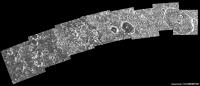
I've finished going through the Voyager 2 narrow-angle data set. The main prize is this 87-frame clear filter mosaic.
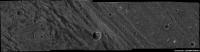
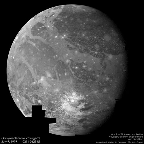 I really want to recommend checking out the full-resolution version of this, because it's like getting to see the New Horizons MVIC image of Pluto for the first time all over again! It looks like the imaging team broke down imaging into multiple smaller mosaics with a little bit of overlap. At the rate that Voyager was approaching the moon, I don't think taking the entire mosaic in a single go would have been possible with the huge change in viewing geometry over the three hours it took to acquire all of the imaging data. I started by assembling all of the submosaics, then warping them so that they aligned with one another. This process didn't require too much warping, although it was getting more difficult by the later mosaics. The image resolution is stopped down to the resolution of the first submosaic on Ganymede's limb, and I need to check the ephemerides to calculate what that resolution was. I've also uploaded the submosaics to my flickr page so you can view them all at full resolution - the later mosaics appear to have 2-3x the image resolution. There are a couple other images that didn't fit neatly into this mosaic. There was a UVIS drift sequence, for which ISS rode along to take support imaging. I've tracked down the locations of these frames and written a short description of the terrain in the FOV. 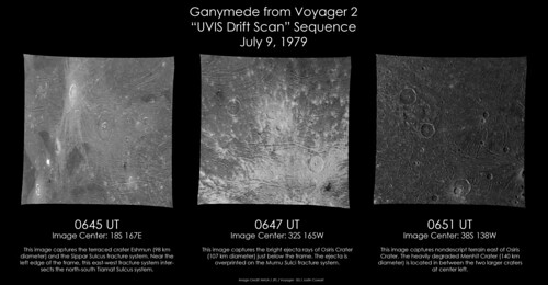 Finally, as Voyager 2 began to recede from Ganymede it looked back and took an 11-frame mosaic of the south pole, which is on the terminator about halfway up the image. 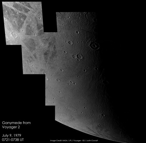 I really need to figure out how to do better geometric control on these images, because it'd be great to try my hand at colorizing these |
|
|
|
 Bjorn Jonsson Voyager and Galileo Images of Ganymede May 18 2007, 09:43 PM
 OWW G2GSNIPPUR01 Nippur Sulcus
At the PPJ:
htt... Nov 13 2007, 11:49 PM
OWW G2GSNIPPUR01 Nippur Sulcus
At the PPJ:
htt... Nov 13 2007, 11:49 PM
 tedstryk And for a different angle, an distant J0 crescent ... Nov 13 2007, 11:59 PM OWW QUOTE (tedstryk @ Nov 14 2007, 12:59 AM) ... Nov 14 2007, 12:58 AM OWW G2GSTRANST01 Marius Regio
PPJ:
http://ph... Nov 14 2007, 12:00 AM OWW G2GSGRVLNS01 Byblus Sulcus
PPJ:
http://phot... Nov 14 2007, 12:06 AM OWW G8GSCALDRA01 Sippar Sulcus calderas
http://p... Nov 14 2007, 12:30 AM OWW G8GSFRACDK01 Southern border of Galileo Regi... Nov 14 2007, 12:35 AM OWW G8GSREGCON01 Marius Regio / Nippur Sulcus
ht... Nov 14 2007, 12:38 AM OWW G7GSNICHOL01 Nicholson Regio / Arbela Sulcu... Nov 14 2007, 12:48 AM OWW G8GSANSHAR01 Anshar Sulcus Nov 14 2007, 12:53 AM OWW G8GSRNGBAS01 Nov 14 2007, 12:57 AM OWW 28GSNICHOL02 Nicholson Regio context
28GSNICHO... Nov 14 2007, 04:42 PM tedstryk Here is a set that shows the problem with relying ... Nov 24 2007, 02:08 PM machi And here is something from my earliest works (i th... Nov 10 2009, 08:21 PM machi Ganymede's south pole region from Voyager 2. A... Oct 1 2010, 03:11 PM Hungry4info That's very nice! Oct 1 2010, 03:53 PM tedstryk Superb work! Oct 1 2010, 04:41 PM Juramike Beautiful! Oct 1 2010, 06:11 PM Bjorn Jonsson One more example of what can be done with the Voya... Oct 1 2010, 06:44 PM machi Thanks!
Yes, new reprocessed images from Voya... Oct 1 2010, 07:16 PM tedstryk Many were processed using a VAX. I can't even... Oct 1 2010, 08:11 PM jasedm Very impressive Machi.
The terrain in the far sout... Oct 1 2010, 08:23 PM Ian R Brilliant work, Daniel!
I'm beginning ... Oct 2 2010, 09:01 AM machi Ian, I have actually similar idea and in fact it... Oct 2 2010, 06:18 PM EDG This is a colour global view of Ganymede, taken us... Oct 18 2010, 03:36 AM DrShank >>I wish I could remember what specific imag... Oct 18 2010, 01:35 PM tedstryk One of my Ganymede mosaics uses that set with wide... Oct 18 2010, 04:28 PM EDG Only 18 images? Seemed like a lot more! (maybe... Oct 18 2010, 06:17 PM ugordan QUOTE (EDG @ Oct 18 2010, 08:17 PM) So ba... Oct 18 2010, 06:41 PM EDG Very nice! Thanks for doing that, I've of... Oct 18 2010, 07:23 PM DrShank its about as close to natural color (at high resol... Oct 18 2010, 11:46 PM EDG Hooray! I just managed to find all my old Gali... Oct 19 2010, 08:10 AM tasp Thanx!! Oct 19 2010, 05:32 PM elakdawalla Since the scripts are just text files and shouldn... Oct 19 2010, 06:26 PM EDG QUOTE (elakdawalla @ Oct 19 2010, 11:26 A... Oct 19 2010, 07:10 PM Bjorn Jonsson Great mosaic, especially when keeping in mind that... Oct 19 2010, 06:48 PM EDG QUOTE (Bjorn Jonsson @ Oct 19 2010, 11:48... Oct 19 2010, 07:11 PM EDG This is the global mosaic of Ganymede's traili... Oct 19 2010, 07:17 PM EDG I was going to start a new thread for this but I t... Oct 20 2010, 07:37 AM tedstryk Cool. That looks like the set I used in this one.... Oct 20 2010, 05:20 PM EDG QUOTE (tedstryk @ Oct 20 2010, 10:20 AM) ... Oct 20 2010, 05:52 PM ugordan EDG, any idea why you have color shifting in the 3... Oct 20 2010, 06:20 PM EDG QUOTE (ugordan @ Oct 20 2010, 10:20 AM) E... Oct 20 2010, 06:47 PM ugordan QUOTE (EDG @ Oct 20 2010, 08:47 PM) Are y... Oct 20 2010, 06:51 PM EDG QUOTE (ugordan @ Oct 20 2010, 11:51 AM) Y... Oct 20 2010, 08:34 PM tedstryk I didn't notice that problem. Oct 20 2010, 08:37 PM tedstryk I am trying to find my notes...I did that image th... Oct 20 2010, 07:27 PM EDG To correct the blurriness (aesthetically anyway), ... Oct 20 2010, 07:40 AM EDG The next attempt is actually as close to true colo... Oct 20 2010, 07:49 AM ugordan QUOTE (EDG @ Oct 20 2010, 09:49 AM) All t... Oct 20 2010, 08:13 AM tedstryk QUOTE (ugordan @ Oct 20 2010, 09:13 AM) P... Oct 20 2010, 05:22 PM EDG And finally, just for kicks I tried an OGU image (... Oct 20 2010, 07:52 AM elakdawalla That is lovely. Is the shift from reddish tones t... Oct 21 2010, 03:29 AM tedstryk Toward the poles, it definitely seems grayer. Oct 21 2010, 03:34 AM ugordan It's supposed to be an irradiation thing - the... Oct 21 2010, 07:41 AM EDG I've found the scripts for the Voyager 1 mosai... Oct 21 2010, 05:24 AM DrShank thats right, those are the aggregate effects of sm... Oct 21 2010, 01:17 PM tedstryk Here is an alternate color mix.
Oct 21 2010, 08:30 PM ngunn Titan has veiled wonders and Io suppurates, but to... Oct 21 2010, 10:35 PM EDG QUOTE (ngunn @ Oct 21 2010, 03:35 PM) Tit... Oct 22 2010, 07:06 AM Decepticon EDG Have you done other moons?
Europa maybe? Nov 23 2010, 05:59 AM Bjorn Jonsson Here is a new global mosaic of Ganymede from Voyag... May 23 2016, 09:19 PM EDG Od's tonsils, Bjorn, that is amazing!
QU... May 25 2016, 10:03 PM Floyd Bjorn that is incredibly good. Thank you for your... May 23 2016, 09:50 PM jccwrt That's spectacular work, Bjorn! Well worth... May 25 2016, 04:48 AM jccwrt Voyager 2 got a great mosaic of the ~600 km wide G... May 26 2016, 02:37 AM JRehling This is all fantastic. Ganymede is truly one of th... May 26 2016, 06:50 PM 4throck QUOTE (JRehling @ May 26 2016, 07:50 PM) ... May 27 2016, 01:43 PM JRehling QUOTE (4throck @ May 27 2016, 06:43 AM) T... May 27 2016, 05:42 PM JRehling QUOTE (4throck @ May 27 2016, 06:43 AM) T... Mar 6 2017, 03:42 AM algorimancer QUOTE (JRehling @ Mar 5 2017, 09:42 PM) .... Mar 6 2017, 08:59 PM scalbers Bjorn's global view has an intriguing crystall... May 26 2016, 07:03 PM Bjorn Jonsson QUOTE (scalbers @ May 26 2016, 07:03 PM) ... May 26 2016, 10:21 PM JRehling Here's what Jupiter looked like the same night... May 27 2016, 05:37 PM JRehling WOW! That blew up to a much larger size than I... May 27 2016, 10:09 PM Bjorn Jonsson Awesome mosaics. The huge global mosaic is probabl... Jun 9 2016, 06:12 PM Ian R Stunning Bjorn! Can't believe this image... Jun 9 2016, 07:01 PM TrappistPlanets (staff team, sorry if this may be considered necro... Oct 11 2021, 07:34 PM stevesliva The paper mentions it's 'PC DEM' where... Oct 11 2021, 08:22 PM TrappistPlanets QUOTE (stevesliva @ Oct 11 2021, 08:22 PM... Oct 11 2021, 09:05 PM antipode Incredibly interesting paper on the ArXiv regardin... May 12 2022, 03:18 AM owlsyme Here is Voyager 1's Ganymede approach -
Fu... May 13 2022, 05:48 PM
tedstryk And for a different angle, an distant J0 crescent ... Nov 13 2007, 11:59 PM OWW QUOTE (tedstryk @ Nov 14 2007, 12:59 AM) ... Nov 14 2007, 12:58 AM OWW G2GSTRANST01 Marius Regio
PPJ:
http://ph... Nov 14 2007, 12:00 AM OWW G2GSGRVLNS01 Byblus Sulcus
PPJ:
http://phot... Nov 14 2007, 12:06 AM OWW G8GSCALDRA01 Sippar Sulcus calderas
http://p... Nov 14 2007, 12:30 AM OWW G8GSFRACDK01 Southern border of Galileo Regi... Nov 14 2007, 12:35 AM OWW G8GSREGCON01 Marius Regio / Nippur Sulcus
ht... Nov 14 2007, 12:38 AM OWW G7GSNICHOL01 Nicholson Regio / Arbela Sulcu... Nov 14 2007, 12:48 AM OWW G8GSANSHAR01 Anshar Sulcus Nov 14 2007, 12:53 AM OWW G8GSRNGBAS01 Nov 14 2007, 12:57 AM OWW 28GSNICHOL02 Nicholson Regio context
28GSNICHO... Nov 14 2007, 04:42 PM tedstryk Here is a set that shows the problem with relying ... Nov 24 2007, 02:08 PM machi And here is something from my earliest works (i th... Nov 10 2009, 08:21 PM machi Ganymede's south pole region from Voyager 2. A... Oct 1 2010, 03:11 PM Hungry4info That's very nice! Oct 1 2010, 03:53 PM tedstryk Superb work! Oct 1 2010, 04:41 PM Juramike Beautiful! Oct 1 2010, 06:11 PM Bjorn Jonsson One more example of what can be done with the Voya... Oct 1 2010, 06:44 PM machi Thanks!
Yes, new reprocessed images from Voya... Oct 1 2010, 07:16 PM tedstryk Many were processed using a VAX. I can't even... Oct 1 2010, 08:11 PM jasedm Very impressive Machi.
The terrain in the far sout... Oct 1 2010, 08:23 PM Ian R Brilliant work, Daniel!
I'm beginning ... Oct 2 2010, 09:01 AM machi Ian, I have actually similar idea and in fact it... Oct 2 2010, 06:18 PM EDG This is a colour global view of Ganymede, taken us... Oct 18 2010, 03:36 AM DrShank >>I wish I could remember what specific imag... Oct 18 2010, 01:35 PM tedstryk One of my Ganymede mosaics uses that set with wide... Oct 18 2010, 04:28 PM EDG Only 18 images? Seemed like a lot more! (maybe... Oct 18 2010, 06:17 PM ugordan QUOTE (EDG @ Oct 18 2010, 08:17 PM) So ba... Oct 18 2010, 06:41 PM EDG Very nice! Thanks for doing that, I've of... Oct 18 2010, 07:23 PM DrShank its about as close to natural color (at high resol... Oct 18 2010, 11:46 PM EDG Hooray! I just managed to find all my old Gali... Oct 19 2010, 08:10 AM tasp Thanx!! Oct 19 2010, 05:32 PM elakdawalla Since the scripts are just text files and shouldn... Oct 19 2010, 06:26 PM EDG QUOTE (elakdawalla @ Oct 19 2010, 11:26 A... Oct 19 2010, 07:10 PM Bjorn Jonsson Great mosaic, especially when keeping in mind that... Oct 19 2010, 06:48 PM EDG QUOTE (Bjorn Jonsson @ Oct 19 2010, 11:48... Oct 19 2010, 07:11 PM EDG This is the global mosaic of Ganymede's traili... Oct 19 2010, 07:17 PM EDG I was going to start a new thread for this but I t... Oct 20 2010, 07:37 AM tedstryk Cool. That looks like the set I used in this one.... Oct 20 2010, 05:20 PM EDG QUOTE (tedstryk @ Oct 20 2010, 10:20 AM) ... Oct 20 2010, 05:52 PM ugordan EDG, any idea why you have color shifting in the 3... Oct 20 2010, 06:20 PM EDG QUOTE (ugordan @ Oct 20 2010, 10:20 AM) E... Oct 20 2010, 06:47 PM ugordan QUOTE (EDG @ Oct 20 2010, 08:47 PM) Are y... Oct 20 2010, 06:51 PM EDG QUOTE (ugordan @ Oct 20 2010, 11:51 AM) Y... Oct 20 2010, 08:34 PM tedstryk I didn't notice that problem. Oct 20 2010, 08:37 PM tedstryk I am trying to find my notes...I did that image th... Oct 20 2010, 07:27 PM EDG To correct the blurriness (aesthetically anyway), ... Oct 20 2010, 07:40 AM EDG The next attempt is actually as close to true colo... Oct 20 2010, 07:49 AM ugordan QUOTE (EDG @ Oct 20 2010, 09:49 AM) All t... Oct 20 2010, 08:13 AM tedstryk QUOTE (ugordan @ Oct 20 2010, 09:13 AM) P... Oct 20 2010, 05:22 PM EDG And finally, just for kicks I tried an OGU image (... Oct 20 2010, 07:52 AM elakdawalla That is lovely. Is the shift from reddish tones t... Oct 21 2010, 03:29 AM tedstryk Toward the poles, it definitely seems grayer. Oct 21 2010, 03:34 AM ugordan It's supposed to be an irradiation thing - the... Oct 21 2010, 07:41 AM EDG I've found the scripts for the Voyager 1 mosai... Oct 21 2010, 05:24 AM DrShank thats right, those are the aggregate effects of sm... Oct 21 2010, 01:17 PM tedstryk Here is an alternate color mix.
Oct 21 2010, 08:30 PM ngunn Titan has veiled wonders and Io suppurates, but to... Oct 21 2010, 10:35 PM EDG QUOTE (ngunn @ Oct 21 2010, 03:35 PM) Tit... Oct 22 2010, 07:06 AM Decepticon EDG Have you done other moons?
Europa maybe? Nov 23 2010, 05:59 AM Bjorn Jonsson Here is a new global mosaic of Ganymede from Voyag... May 23 2016, 09:19 PM EDG Od's tonsils, Bjorn, that is amazing!
QU... May 25 2016, 10:03 PM Floyd Bjorn that is incredibly good. Thank you for your... May 23 2016, 09:50 PM jccwrt That's spectacular work, Bjorn! Well worth... May 25 2016, 04:48 AM jccwrt Voyager 2 got a great mosaic of the ~600 km wide G... May 26 2016, 02:37 AM JRehling This is all fantastic. Ganymede is truly one of th... May 26 2016, 06:50 PM 4throck QUOTE (JRehling @ May 26 2016, 07:50 PM) ... May 27 2016, 01:43 PM JRehling QUOTE (4throck @ May 27 2016, 06:43 AM) T... May 27 2016, 05:42 PM JRehling QUOTE (4throck @ May 27 2016, 06:43 AM) T... Mar 6 2017, 03:42 AM algorimancer QUOTE (JRehling @ Mar 5 2017, 09:42 PM) .... Mar 6 2017, 08:59 PM scalbers Bjorn's global view has an intriguing crystall... May 26 2016, 07:03 PM Bjorn Jonsson QUOTE (scalbers @ May 26 2016, 07:03 PM) ... May 26 2016, 10:21 PM JRehling Here's what Jupiter looked like the same night... May 27 2016, 05:37 PM JRehling WOW! That blew up to a much larger size than I... May 27 2016, 10:09 PM Bjorn Jonsson Awesome mosaics. The huge global mosaic is probabl... Jun 9 2016, 06:12 PM Ian R Stunning Bjorn! Can't believe this image... Jun 9 2016, 07:01 PM TrappistPlanets (staff team, sorry if this may be considered necro... Oct 11 2021, 07:34 PM stevesliva The paper mentions it's 'PC DEM' where... Oct 11 2021, 08:22 PM TrappistPlanets QUOTE (stevesliva @ Oct 11 2021, 08:22 PM... Oct 11 2021, 09:05 PM antipode Incredibly interesting paper on the ArXiv regardin... May 12 2022, 03:18 AM owlsyme Here is Voyager 1's Ganymede approach -
Fu... May 13 2022, 05:48 PM |

|
Lo-Fi Version | Time is now: 26th September 2024 - 10:55 PM |
|
RULES AND GUIDELINES Please read the Forum Rules and Guidelines before posting. IMAGE COPYRIGHT |
OPINIONS AND MODERATION Opinions expressed on UnmannedSpaceflight.com are those of the individual posters and do not necessarily reflect the opinions of UnmannedSpaceflight.com or The Planetary Society. The all-volunteer UnmannedSpaceflight.com moderation team is wholly independent of The Planetary Society. The Planetary Society has no influence over decisions made by the UnmannedSpaceflight.com moderators. |
SUPPORT THE FORUM Unmannedspaceflight.com is funded by the Planetary Society. Please consider supporting our work and many other projects by donating to the Society or becoming a member. |
|