
Adaptive Optics, Tracking the SOTA for ground-based observation |

Adaptive Optics, Tracking the SOTA for ground-based observation |
 Nov 16 2016, 06:23 PM Nov 16 2016, 06:23 PM
Post
#1
|
|
 Senior Member  Group: Members Posts: 2530 Joined: 20-April 05 Member No.: 321 |
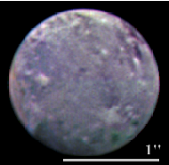
Here, as mentioned in the Neptune thread, is a link to an article about the PALM-3000 system working with the 5m Hale Telescope. The attached photo of Ganymede is one of the best ground-based images I've ever seen, and easily blows away HST resolution.
http://inspirehep.net/record/1252803/plots
Attached image(s)
|
 |
 
|
 |
|
Nov 17 2016, 03:18 PM
Post
#2
|
|
|
Solar System Cartographer Group: Members Posts: 10193 Joined: 5-April 05 From: Canada Member No.: 227 |
"Rotate Phil's 90° clockwise."
No, rotate the other one! Mine has north at the top. Call me old-fashioned but that's the way I like it. Phil -------------------- ... because the Solar System ain't gonna map itself.
Also to be found posting similar content on https://mastodon.social/@PhilStooke Maps for download (free PD: https://upload.wikimedia.org/wikipedia/comm...Cartography.pdf NOTE: everything created by me which I post on UMSF is considered to be in the public domain (NOT CC, public domain) |
|
|
|
|
Nov 19 2016, 12:32 AM
Post
#3
|
|
 Member Group: Members Posts: 593 Joined: 20-April 05 Member No.: 279 |
QUOTE (Phil Stooke @ Nov 17 2016, 03:18 PM)  "Rotate Phil's 90° clockwise." No, rotate the other one! Mine has north at the top. Call me old-fashioned but that's the way I like it. Phil Phil, you're old-fashioned.  Andy |
|
|
|
|
Nov 20 2016, 08:46 PM
Post
#4
|
|
|
Senior Member Group: Members Posts: 2530 Joined: 20-April 05 Member No.: 321 |
In astronomy, old fashioned puts south at the top.
One of the great delights of my astrophotography is the fact that the capture software I use allows mirror reflections to be elected at the flick of a switch. One simple click, made once, and I ever after see the correct orientation on my computer screen. It always bothered me to no end that astronomers sketching the Moon, Mars, etc., used to make south-up maps instead of performing the simple transformation. |
|
|
|
 JRehling Adaptive Optics Nov 16 2016, 06:23 PM
 Bjorn Jonsson Wow!!!!
Somehow the fact that gro... Nov 16 2016, 08:35 PM
Bjorn Jonsson Wow!!!!
Somehow the fact that gro... Nov 16 2016, 08:35 PM
 JRehling It certainly is impressive. Not quite Voyager leve... Nov 17 2016, 03:01 PM Phil Stooke Wow indeed. Amazing. OK, now I want to see... th... Nov 17 2016, 02:14 AM Decepticon The features don't seem to line up? Nov 17 2016, 07:57 AM AndyG Rotate Phil's 90° clockwise.
Andy Nov 17 2016, 08:25 AM algorimancer Thanks for posting. That is crazy impressive reso... Nov 17 2016, 05:56 PM JRehling QUOTE (algorimancer @ Nov 17 2016, 10:56 ... Nov 17 2016, 06:42 PM algorimancer I see that there is the ESO's VLTI, which is a... Nov 17 2016, 07:54 PM Gerald QUOTE (algorimancer @ Nov 17 2016, 09:54 ... Nov 18 2016, 08:55 PM algorimancer QUOTE (Gerald @ Nov 18 2016, 02:55 PM) ..... Nov 18 2016, 10:10 PM Phil Stooke I don't know a lot about this, but my impressi... Nov 17 2016, 08:15 PM Decepticon RE: Adaptive Optics Nov 17 2016, 08:19 PM algorimancer It's interesting to compare this adaptive opti... Nov 18 2016, 03:21 PM Phil Stooke I guess I asked for that...
Phil
PS get off my l... Nov 20 2016, 07:30 PM Phil Stooke Totally off topic, but look what happens when you ... Nov 21 2016, 03:25 PM
JRehling It certainly is impressive. Not quite Voyager leve... Nov 17 2016, 03:01 PM Phil Stooke Wow indeed. Amazing. OK, now I want to see... th... Nov 17 2016, 02:14 AM Decepticon The features don't seem to line up? Nov 17 2016, 07:57 AM AndyG Rotate Phil's 90° clockwise.
Andy Nov 17 2016, 08:25 AM algorimancer Thanks for posting. That is crazy impressive reso... Nov 17 2016, 05:56 PM JRehling QUOTE (algorimancer @ Nov 17 2016, 10:56 ... Nov 17 2016, 06:42 PM algorimancer I see that there is the ESO's VLTI, which is a... Nov 17 2016, 07:54 PM Gerald QUOTE (algorimancer @ Nov 17 2016, 09:54 ... Nov 18 2016, 08:55 PM algorimancer QUOTE (Gerald @ Nov 18 2016, 02:55 PM) ..... Nov 18 2016, 10:10 PM Phil Stooke I don't know a lot about this, but my impressi... Nov 17 2016, 08:15 PM Decepticon RE: Adaptive Optics Nov 17 2016, 08:19 PM algorimancer It's interesting to compare this adaptive opti... Nov 18 2016, 03:21 PM Phil Stooke I guess I asked for that...
Phil
PS get off my l... Nov 20 2016, 07:30 PM Phil Stooke Totally off topic, but look what happens when you ... Nov 21 2016, 03:25 PM |

|
Lo-Fi Version | Time is now: 16th June 2024 - 09:41 AM |
|
RULES AND GUIDELINES Please read the Forum Rules and Guidelines before posting. IMAGE COPYRIGHT |
OPINIONS AND MODERATION Opinions expressed on UnmannedSpaceflight.com are those of the individual posters and do not necessarily reflect the opinions of UnmannedSpaceflight.com or The Planetary Society. The all-volunteer UnmannedSpaceflight.com moderation team is wholly independent of The Planetary Society. The Planetary Society has no influence over decisions made by the UnmannedSpaceflight.com moderators. |
SUPPORT THE FORUM Unmannedspaceflight.com is funded by the Planetary Society. Please consider supporting our work and many other projects by donating to the Society or becoming a member. |
|


