Juno perijove 4, February 2, 2017 |

Juno perijove 4, February 2, 2017 |
 Jan 20 2017, 11:16 PM Jan 20 2017, 11:16 PM
Post
#1
|
|
|
Senior Member  Group: Members Posts: 2346 Joined: 7-December 12 Member No.: 6780 |
It's time to open a perijove-4 thread.
Voting is open for another two days. So, don't hesitate too long. Besides the discussion and the POIs on the mission page, you might consider John Roger's detailed discussion of several interesting features. If everything goes well, all instruments will be switched on. |
 |
 
|
 |
|
Mar 7 2017, 12:24 AM
Post
#2
|
|||
 IMG to PNG GOD Group: Moderator Posts: 2254 Joined: 19-February 04 From: Near fire and ice Member No.: 38 |
Now at last I took the time to finish the Juno-related software development I started around the time of the Juno Earth flyby back in 2013. Now I can reproject the raw framelets to simple cylindrical projection and render the resulting maps, resulting in nice images.
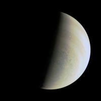
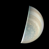
Here is a test image. This is image 119 ("radiation trend monitoring"). It was obtained on February 2, 2017 when Juno was ~340,000 km from Jupiter's center on the outbound leg of its trajectory. I selected this image because it's a global image where limb fits are trivial - this makes debugging stuff easier.
The left version is the image with almost no processing except for color correction and some sharpening. In the right version global illumination has been removed using a modified Lommel-Seeliger function and the contrast greatly exaggerated. In the original images the area near Jupiter's right limb is saturated in the red and green channels, resulting in very low contrast and slightly strange color. Interestingly, the saturated value in the original raw images is 240. The contrast is rather low. I suspect I need to add square root encoding to the processing to increase the contrast; I noticed that Gerald does this. One thing that caused me some minor headaches was a part the SPICE instrument kernel file, specifically this section: CODE --- 0,0---------------------|----------------------. | 230 pixels 4.94 deg | RED 128 pix * | -------- --- `----------------------|------------------1600,128 | V +Yjc | 61.69 deg | Boresight |---------------------------------------------| (+Zjc axis) | | is into the page Maybe I'm missing something elementary but the value 61.69 deg seems strange and I get weird results if I use it. However, a 58.015 deg field of view for all 1648 pixels works perfectly and is also consistent with the 58 deg value for JunoCam that I've seen elsewhere and it's also consistent with JunoCam's focal length and pixel size. As usual a big part of the work involved correcting the pointing. I used SPICE kernels and software I wrote using the SPICE toolkit to get the spacecraft position and pointing and to optionally correct the pointing (somewhat comparable to what the ISIS3 deltack program does). For the interested, here is an example of the output. It's somewhat similar to a PDS label file but with some 'new' custom labels that I added. CODE /* Spicegeom version 2017-02-28 */ TARGET_NAME="Jupiter" SPACECRAFT_NAME="Juno" IMAGE_NUMBER=" -1" IMAGE_TIME="2017-FEB-02 15:57:44.297" SC_TARGET_POSITION_VECTOR=(-148470.35180453,63094.92703727,-301286.56346215) TARGET_CENTER_DISTANCE=341757.236215459 SUB_SPACECRAFT_LATITUDE=-61.833627009783 SUB_SPACECRAFT_LONGITUDE=203.026167185770 SUB_SPACECRAFT_LINE_SAMPLE=832.2795709754 SUB_SPACECRAFT_LINE=738.4562742541 SAMPLE_TO_BE_CORRECTED=494.0000000000 LINE_TO_BE_CORRECTED=753.0000000000 SAMPLE_CORRECTION=-20.0000000000 LINE_CORRECTION=7.0000000000 NORTH_AZIMUTH=90.45299584 FIELD_OF_VIEW=58.01500000 /* LOOK_AT includes a possible user-specified correction to LINE[_SAMPLE] */ /* In contrast, SUB_SPACECRAFT_LINE[_SAMPLE] does not include this correction */ LOOK_AT_X=-143367.5394205331 LOOK_AT_Z=-292943.9225293422 LOOK_AT_Y=61006.4711387579 PLANETOGRAPHIC_SUB_SPACECRAFT_LATITUDE=-64.90958822 SUB_SOLAR_LATITUDE=-2.582962 SUB_SOLAR_LONGITUDE=100.197161 SOLAR_DISTANCE=815580051.923982 PLANETOGRAPHIC_SUB_SOLAR_LATITUDE=-2.953164 PHASE_ANGLE=93.724392 Next: Processing a much closer and higher resolution image of Jupiter. |
||
|
|
|
||
|
Mar 7 2017, 08:26 AM
Post
#3
|
|
|
Senior Member Group: Members Posts: 2346 Joined: 7-December 12 Member No.: 6780 |
QUOTE (Bjorn Jonsson @ Mar 7 2017, 01:24 AM)  The contrast is rather low. I suspect I need to add square root encoding to the processing to increase the contrast; I noticed that Gerald does this. The square root encoding returns low contrast, similar to the raws, but it covers most of the dynamical range of "natural" colors. One option I'm using to enhance the images is a gamma-stretch of the illumination-adjusted version, by a gamma of 4 with respect to the square-root encoded version, i.e. by using the square of the (approximately) radiometrically calibrated data. In your enhanced image, I see, that you get color banding, as others including me, had been getting for quite a period of time. That's due to the piece-wise linear de-companding function, substantially deviating from square-root encoding. Your Lommel-Seeliger model seems to work considerably better than the very simple Lambert model I'm using. Thanks for this hint! I've been going to infer the illumination model empirically. |
|
|
|
|
Mar 8 2017, 01:36 AM
Post
#4
|
||||
|
IMG to PNG GOD Group: Moderator Posts: 2254 Joined: 19-February 04 From: Near fire and ice Member No.: 38 |
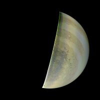
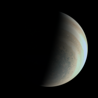
QUOTE (Gerald @ Mar 7 2017, 08:26 AM) In your enhanced image, I see, that you get color banding, as others including me, had been getting for quite a period of time. That's due to the piece-wise linear de-companding function, substantially deviating from square-root encoding. Your Lommel-Seeliger model seems to work considerably better than the very simple Lambert model I'm using. Thanks for this hint! I've been going to infer the illumination model empirically. I found the SQROOT companding table and added it to my software - I'm now getting greatly improved results by decompanding the data. Here is first a simple cylindrical map with global illumination removed. Latitude is planetographic. Lommel-Seeliger works better than simple Lambert, especially in the modified form I'm using. The modification is to apply an exponent to the cosines of the incidence and emission angles. I'm currently using a value of 1.1 but this can probably be improved slightly. I also experimented with a Backstorm function but it probably doesn't work as well as modified Lommel-Seeliger (I need to check this more carefully though).
It should be noted that to correct the color where R/G is saturated I made some manual modifications to the map in Photoshop and I also made minor adjustments near the terminator. And here are new versions of the images I posted yesterday. These new versions are significantly better.
The color correction I'm using is preliminary (without it the images are far too yellowish). It will probably change a bit but nevertheless this shouldn't be too far from Jupiter's true color. |
|||
|
|
|
|||
 Gerald Juno perijove 4 Jan 20 2017, 11:16 PM
 PhilipTerryGraham It'll be good to see JIRAM up and running agai... Jan 22 2017, 02:34 PM PhilipTerryGraham I redecorated the subreddit again, this time in an... Jan 30 2017, 08:44 PM mcaplinger Unofficial status: Be advised that even though PJ4... Feb 2 2017, 05:04 AM
 mcaplinger QUOTE (mcaplinger @ Feb 1 2017, 09:04 PM)... Feb 3 2017, 09:56 PM Gerald QUOTE (mcaplinger @ Feb 3 2017, 10:56 PM)... Feb 4 2017, 05:28 AM Gerald Thanks a lot! This helps planning the processi... Feb 2 2017, 04:38 PM PhilipTerryGraham Any word on JIRAM or Waves stuff, by any chance? Feb 2 2017, 10:54 PM mcaplinger Note that this pass was in the MWR attitude so the... Feb 2 2017, 11:10 PM Gerald According to the updated news, all instruments hav... Feb 3 2017, 11:21 AM PhilipTerryGraham They did it again, releasing JunoCam data much ear... Feb 4 2017, 02:18 AM Gerald Here a draft version of RGB close-ups. This versio... Feb 4 2017, 05:07 PM Roman Tkachenko The Pearl of Jupiter Feb 4 2017, 06:07 PM mcaplinger QUOTE (Roman Tkachenko @ Feb 4 2017, 10:0... Feb 8 2017, 07:45 PM Roman Tkachenko QUOTE (mcaplinger @ Feb 8 2017, 11:45 PM)... Feb 20 2017, 03:28 PM jccwrt The final image of Jupiter's south pole using ... Feb 4 2017, 11:31 PM t_oner Enhanced Justin's image a little bit. Feb 5 2017, 08:55 PM Roman Tkachenko Jupiter's South Pole (PJ-4) Feb 6 2017, 08:56 AM PaulH51 QUOTE (Roman Tkachenko @ Feb 6 2017, 04:5... Feb 6 2017, 09:12 AM Gerald This is a 5-fold reduced full version of the PJ04 ... Feb 9 2017, 12:14 AM nprev Mike, your 'mediocre' camera is beyond the... Feb 9 2017, 01:58 AM Gerald Selected PJ04 Approach Movie RGB images.
Enhanced ... Feb 9 2017, 09:03 PM Gerald The first 20 PJ-04 Departure Movie images.
These d... Feb 13 2017, 09:18 PM PhilipTerryGraham QUOTE (nprev @ Feb 9 2017, 12:58 PM) Mike... Feb 14 2017, 03:26 PM mcaplinger QUOTE (PhilipTerryGraham @ Feb 14 2017, 07... Feb 14 2017, 05:41 PM PhilipTerryGraham QUOTE (mcaplinger @ Feb 15 2017, 04:41 AM... Feb 14 2017, 07:13 PM Explorer1 Say they are lucky to get any images at all, and t... Feb 14 2017, 08:58 PM mcaplinger QUOTE (Explorer1 @ Feb 14 2017, 12:58 PM)... Feb 14 2017, 09:53 PM JRehling QUOTE (mcaplinger @ Feb 14 2017, 02:53 PM... Feb 22 2017, 08:58 PM PhilipTerryGraham An interesting question was brought up by my frien... Feb 19 2017, 07:07 AM jccwrt I took a look a while back, but that was still whe... Feb 19 2017, 07:21 PM Gerald PJ05 is 2017 MAR 27 08:52:14 (according to SPICE s... Feb 19 2017, 10:05 PM mcaplinger QUOTE (Gerald @ Feb 19 2017, 02:05 PM) Th... Feb 19 2017, 11:41 PM Floyd Adding 53.5 days to last known perijove is difficu... Feb 20 2017, 01:53 AM mcaplinger QUOTE (Floyd @ Feb 19 2017, 05:53 PM) Add... Feb 20 2017, 03:35 AM Gerald PJ03 Image #73 has been taken 6h42m before PJ04, i... Feb 20 2017, 09:01 AM PhilipTerryGraham Here's what Eyes on the Solar System has in it... Feb 21 2017, 04:31 PM Gerald The most accurate published times for perijoves 6 ... Feb 21 2017, 06:05 PM mcaplinger The most accurate source of PJ times I know of are... Feb 21 2017, 06:43 PM PhilipTerryGraham QUOTE (mcaplinger @ Feb 22 2017, 05:43 AM... Feb 21 2017, 07:21 PM Gerald For the simulation you require more than just the ... Feb 21 2017, 09:45 PM mcaplinger QUOTE (Gerald @ Feb 21 2017, 01:45 PM) Fo... Feb 21 2017, 10:04 PM JRehling FYI, Io shadow passes across Jupiter occur every 4... Mar 6 2017, 09:29 PM PhilipTerryGraham Congrats to Roman for what is now his third image ... Feb 24 2017, 05:11 PM Roman Tkachenko QUOTE (PhilipTerryGraham @ Feb 24 2017, 09... Feb 24 2017, 11:26 PM Gerald Selected PJ04 images cylindrically map projected, ... Mar 6 2017, 09:12 PM mcaplinger QUOTE (Bjorn Jonsson @ Mar 6 2017, 04:24 ... Mar 7 2017, 01:42 AM Gerald Montage of cylindrical planetocentrical PJ04 maps ... Mar 8 2017, 03:26 AM Gerald The individual cropped cylindrical PJ-04 maps, som... Mar 8 2017, 10:00 PM Roman Tkachenko Dark Spot and Jovian 'Galaxy' (Enhanced Co... Mar 9 2017, 01:23 PM Bjorn Jonsson QUOTE (Roman Tkachenko @ Mar 9 2017, 01:2... Mar 9 2017, 09:55 PM JRehling As we all know, Jupiter has a visible "surfac... Mar 10 2017, 05:01 AM Gerald QUOTE (JRehling @ Mar 10 2017, 06:01 AM) ... Mar 10 2017, 10:51 AM stevesliva QUOTE (Bjorn Jonsson @ Mar 9 2017, 04:55 ... Mar 10 2017, 05:17 PM Gerald Nice!
Some more recreation:
Oval BA and ... Mar 9 2017, 09:01 PM Gerald Roman's image shows parts of the northern hemi... Mar 11 2017, 01:45 AM Gerald I wondered, whether the polar CH4 images can be pa... Mar 11 2017, 08:24 PM Gerald PJ04 #102 in the context of #085 and #122:
(NASA ... Mar 14 2017, 02:45 AM Gerald A more complete set of rgb and methane band cylind... Mar 15 2017, 01:59 AM Bjorn Jonsson The JunoCam images are in a word awesome. They are... Mar 24 2017, 07:51 PM JRehling Amazing, Bjorn, and wonderful. The white ovals are... Mar 27 2017, 02:32 AM PhilipTerryGraham Wow Bjorn! This is some absolutely incredible ... Mar 24 2017, 08:22 PM stevesliva QUOTE (PhilipTerryGraham @ Mar 24 2017, 03... Mar 26 2017, 01:33 AM Gerald Well, each perijove would/should allow for dozens ... Mar 26 2017, 11:44 AM Gerald Here the first 170 frames of the same sequence as ... Mar 26 2017, 09:13 PM Gerald A 361 frames AVI version (125-fold time-lapse) of ... Mar 27 2017, 06:11 AM Gerald PJ-04 animation on youtube derived from images #09... Mar 28 2017, 02:27 PM Sean PJ04 portrait based on Gerald's work...
Det... May 24 2017, 12:36 PM Sean I'm constantly surprised how much detail can b... May 24 2017, 01:49 PM Sean PJ04 portraits...testing some new blending methods... May 24 2017, 04:29 PM jccwrt I think I found some examples of gravity waves in ... May 26 2017, 09:35 PM Sean PJ04_109 portrait using Gerald's work... May 28 2017, 08:36 PM Sean Here is a Juno sketch... Jun 4 2017, 07:36 PM Bjorn Jonsson This is a highly speculative experimental anaglyph... Sep 4 2017, 01:24 PM JRehling Bjorn, I love the anaglyphs.
One possibly helpful... Dec 11 2017, 04:07 PM Sean PJ04_106 Dec 8 2017, 08:10 PM Sean PJ04_101 Detail Dec 11 2017, 03:37 PM Gerald The channels are essentially mixed. You won't ... Dec 11 2017, 06:42 PM Sean PJ04_100
PJ04_100 detail Dec 11 2017, 08:58 PM Sean PJ04_099 [ after Gerald's work ]
Detail 00... Dec 11 2017, 11:58 PM Sean PJ04_107
Details Dec 12 2017, 03:07 PM Gerald A first revision of the Perijove-04 animation is o... Dec 14 2017, 05:17 PM Sean More tinkering with PJ04_101 [G.Eichstadt] this ti... Dec 15 2017, 01:51 AM Sean PJ04_107 update [G.Eichstadt] Dec 16 2017, 07:14 PM Sean PJ04_100 update [G.Eichstadt] Dec 16 2017, 08:36 PM Sean PJ04_106 details & portrait, new pass Apr 16 2018, 11:39 PM Sean A new take on PJ04_106 GE/SD Mar 21 2019, 09:36 PM
mcaplinger QUOTE (mcaplinger @ Feb 1 2017, 09:04 PM)... Feb 3 2017, 09:56 PM Gerald QUOTE (mcaplinger @ Feb 3 2017, 10:56 PM)... Feb 4 2017, 05:28 AM Gerald Thanks a lot! This helps planning the processi... Feb 2 2017, 04:38 PM PhilipTerryGraham Any word on JIRAM or Waves stuff, by any chance? Feb 2 2017, 10:54 PM mcaplinger Note that this pass was in the MWR attitude so the... Feb 2 2017, 11:10 PM Gerald According to the updated news, all instruments hav... Feb 3 2017, 11:21 AM PhilipTerryGraham They did it again, releasing JunoCam data much ear... Feb 4 2017, 02:18 AM Gerald Here a draft version of RGB close-ups. This versio... Feb 4 2017, 05:07 PM Roman Tkachenko The Pearl of Jupiter Feb 4 2017, 06:07 PM mcaplinger QUOTE (Roman Tkachenko @ Feb 4 2017, 10:0... Feb 8 2017, 07:45 PM Roman Tkachenko QUOTE (mcaplinger @ Feb 8 2017, 11:45 PM)... Feb 20 2017, 03:28 PM jccwrt The final image of Jupiter's south pole using ... Feb 4 2017, 11:31 PM t_oner Enhanced Justin's image a little bit. Feb 5 2017, 08:55 PM Roman Tkachenko Jupiter's South Pole (PJ-4) Feb 6 2017, 08:56 AM PaulH51 QUOTE (Roman Tkachenko @ Feb 6 2017, 04:5... Feb 6 2017, 09:12 AM Gerald This is a 5-fold reduced full version of the PJ04 ... Feb 9 2017, 12:14 AM nprev Mike, your 'mediocre' camera is beyond the... Feb 9 2017, 01:58 AM Gerald Selected PJ04 Approach Movie RGB images.
Enhanced ... Feb 9 2017, 09:03 PM Gerald The first 20 PJ-04 Departure Movie images.
These d... Feb 13 2017, 09:18 PM PhilipTerryGraham QUOTE (nprev @ Feb 9 2017, 12:58 PM) Mike... Feb 14 2017, 03:26 PM mcaplinger QUOTE (PhilipTerryGraham @ Feb 14 2017, 07... Feb 14 2017, 05:41 PM PhilipTerryGraham QUOTE (mcaplinger @ Feb 15 2017, 04:41 AM... Feb 14 2017, 07:13 PM Explorer1 Say they are lucky to get any images at all, and t... Feb 14 2017, 08:58 PM mcaplinger QUOTE (Explorer1 @ Feb 14 2017, 12:58 PM)... Feb 14 2017, 09:53 PM JRehling QUOTE (mcaplinger @ Feb 14 2017, 02:53 PM... Feb 22 2017, 08:58 PM PhilipTerryGraham An interesting question was brought up by my frien... Feb 19 2017, 07:07 AM jccwrt I took a look a while back, but that was still whe... Feb 19 2017, 07:21 PM Gerald PJ05 is 2017 MAR 27 08:52:14 (according to SPICE s... Feb 19 2017, 10:05 PM mcaplinger QUOTE (Gerald @ Feb 19 2017, 02:05 PM) Th... Feb 19 2017, 11:41 PM Floyd Adding 53.5 days to last known perijove is difficu... Feb 20 2017, 01:53 AM mcaplinger QUOTE (Floyd @ Feb 19 2017, 05:53 PM) Add... Feb 20 2017, 03:35 AM Gerald PJ03 Image #73 has been taken 6h42m before PJ04, i... Feb 20 2017, 09:01 AM PhilipTerryGraham Here's what Eyes on the Solar System has in it... Feb 21 2017, 04:31 PM Gerald The most accurate published times for perijoves 6 ... Feb 21 2017, 06:05 PM mcaplinger The most accurate source of PJ times I know of are... Feb 21 2017, 06:43 PM PhilipTerryGraham QUOTE (mcaplinger @ Feb 22 2017, 05:43 AM... Feb 21 2017, 07:21 PM Gerald For the simulation you require more than just the ... Feb 21 2017, 09:45 PM mcaplinger QUOTE (Gerald @ Feb 21 2017, 01:45 PM) Fo... Feb 21 2017, 10:04 PM JRehling FYI, Io shadow passes across Jupiter occur every 4... Mar 6 2017, 09:29 PM PhilipTerryGraham Congrats to Roman for what is now his third image ... Feb 24 2017, 05:11 PM Roman Tkachenko QUOTE (PhilipTerryGraham @ Feb 24 2017, 09... Feb 24 2017, 11:26 PM Gerald Selected PJ04 images cylindrically map projected, ... Mar 6 2017, 09:12 PM mcaplinger QUOTE (Bjorn Jonsson @ Mar 6 2017, 04:24 ... Mar 7 2017, 01:42 AM Gerald Montage of cylindrical planetocentrical PJ04 maps ... Mar 8 2017, 03:26 AM Gerald The individual cropped cylindrical PJ-04 maps, som... Mar 8 2017, 10:00 PM Roman Tkachenko Dark Spot and Jovian 'Galaxy' (Enhanced Co... Mar 9 2017, 01:23 PM Bjorn Jonsson QUOTE (Roman Tkachenko @ Mar 9 2017, 01:2... Mar 9 2017, 09:55 PM JRehling As we all know, Jupiter has a visible "surfac... Mar 10 2017, 05:01 AM Gerald QUOTE (JRehling @ Mar 10 2017, 06:01 AM) ... Mar 10 2017, 10:51 AM stevesliva QUOTE (Bjorn Jonsson @ Mar 9 2017, 04:55 ... Mar 10 2017, 05:17 PM Gerald Nice!
Some more recreation:
Oval BA and ... Mar 9 2017, 09:01 PM Gerald Roman's image shows parts of the northern hemi... Mar 11 2017, 01:45 AM Gerald I wondered, whether the polar CH4 images can be pa... Mar 11 2017, 08:24 PM Gerald PJ04 #102 in the context of #085 and #122:
(NASA ... Mar 14 2017, 02:45 AM Gerald A more complete set of rgb and methane band cylind... Mar 15 2017, 01:59 AM Bjorn Jonsson The JunoCam images are in a word awesome. They are... Mar 24 2017, 07:51 PM JRehling Amazing, Bjorn, and wonderful. The white ovals are... Mar 27 2017, 02:32 AM PhilipTerryGraham Wow Bjorn! This is some absolutely incredible ... Mar 24 2017, 08:22 PM stevesliva QUOTE (PhilipTerryGraham @ Mar 24 2017, 03... Mar 26 2017, 01:33 AM Gerald Well, each perijove would/should allow for dozens ... Mar 26 2017, 11:44 AM Gerald Here the first 170 frames of the same sequence as ... Mar 26 2017, 09:13 PM Gerald A 361 frames AVI version (125-fold time-lapse) of ... Mar 27 2017, 06:11 AM Gerald PJ-04 animation on youtube derived from images #09... Mar 28 2017, 02:27 PM Sean PJ04 portrait based on Gerald's work...
Det... May 24 2017, 12:36 PM Sean I'm constantly surprised how much detail can b... May 24 2017, 01:49 PM Sean PJ04 portraits...testing some new blending methods... May 24 2017, 04:29 PM jccwrt I think I found some examples of gravity waves in ... May 26 2017, 09:35 PM Sean PJ04_109 portrait using Gerald's work... May 28 2017, 08:36 PM Sean Here is a Juno sketch... Jun 4 2017, 07:36 PM Bjorn Jonsson This is a highly speculative experimental anaglyph... Sep 4 2017, 01:24 PM JRehling Bjorn, I love the anaglyphs.
One possibly helpful... Dec 11 2017, 04:07 PM Sean PJ04_106 Dec 8 2017, 08:10 PM Sean PJ04_101 Detail Dec 11 2017, 03:37 PM Gerald The channels are essentially mixed. You won't ... Dec 11 2017, 06:42 PM Sean PJ04_100
PJ04_100 detail Dec 11 2017, 08:58 PM Sean PJ04_099 [ after Gerald's work ]
Detail 00... Dec 11 2017, 11:58 PM Sean PJ04_107
Details Dec 12 2017, 03:07 PM Gerald A first revision of the Perijove-04 animation is o... Dec 14 2017, 05:17 PM Sean More tinkering with PJ04_101 [G.Eichstadt] this ti... Dec 15 2017, 01:51 AM Sean PJ04_107 update [G.Eichstadt] Dec 16 2017, 07:14 PM Sean PJ04_100 update [G.Eichstadt] Dec 16 2017, 08:36 PM Sean PJ04_106 details & portrait, new pass Apr 16 2018, 11:39 PM Sean A new take on PJ04_106 GE/SD Mar 21 2019, 09:36 PM |

|
Lo-Fi Version | Time is now: 21st September 2024 - 07:10 AM |
|
RULES AND GUIDELINES Please read the Forum Rules and Guidelines before posting. IMAGE COPYRIGHT |
OPINIONS AND MODERATION Opinions expressed on UnmannedSpaceflight.com are those of the individual posters and do not necessarily reflect the opinions of UnmannedSpaceflight.com or The Planetary Society. The all-volunteer UnmannedSpaceflight.com moderation team is wholly independent of The Planetary Society. The Planetary Society has no influence over decisions made by the UnmannedSpaceflight.com moderators. |
SUPPORT THE FORUM Unmannedspaceflight.com is funded by the Planetary Society. Please consider supporting our work and many other projects by donating to the Society or becoming a member. |
|