Juno perijove 5, March 27, 2017 |

Juno perijove 5, March 27, 2017 |
 Mar 16 2017, 10:24 PM Mar 16 2017, 10:24 PM
Post
#1
|
|
 IMG to PNG GOD  Group: Moderator Posts: 2254 Joined: 19-February 04 From: Near fire and ice Member No.: 38 |
Juno's perijove 5 is coming up less than two weeks from now - it's on March 27, 2017.
The target selection voting has started and is open until almost four days from now: https://www.missionjuno.swri.edu/junocam/voting?current A large part of the data volume will be reserved for polar time lapse sequences though. John Rogers has written a helpful summary of the upcoming perijove 5: https://www.britastro.org/node/9377 |
 |
 
|
 |
|
Apr 2 2017, 08:51 AM
Post
#2
|
||
|
Senior Member Group: Members Posts: 2346 Joined: 7-December 12 Member No.: 6780 |
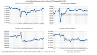
For completeness, here the statistics resulting from the calibration run:
There are peaks and discontinuities near the change of the s/c spin axis. But at least the camera's optical axis shouldn't change during these maneuvers, with the x-position near 812. The inconsistencies indicate residual flaws in the model, and help to uncover them. |
|
|
|
|
|
|
Apr 3 2017, 12:10 AM
Post
#3
|
||
|
IMG to PNG GOD Group: Moderator Posts: 2254 Joined: 19-February 04 From: Near fire and ice Member No.: 38 |
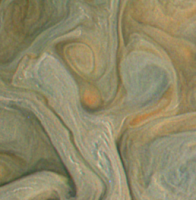
QUOTE (Gerald @ Apr 2 2017, 08:51 AM)  For completeness, here the statistics resulting from the calibration run: Have you checked how accurate the interframe delay in the metadata is? For the PJ5 images it is 0.371 but I'm starting to suspect that I might get slightly better results by adjusting it slightly. I haven't tried it yet though but I'm pretty sure any adjustment (if needed) is less than 0.001. QUOTE (Gerald @ Mar 31 2017, 11:45 PM) Is it possible to discern any rotation in these large storms within the five and a half minutes between images #109 and #110? My best candidate is the large white (anticyclonic) oval A6: Quick back of the envelope calculations seem to suggest this *might* be possible. The elapsed time between the images is ~330 seconds. Assuming a wind speed of ~60 m/s near the A6 spot's periphery (a very crude but probably not bad assumption made by scaling down the speed in the bigger white oval BC in the Voyager era by a factor of ~2 since A6 is smaller) results in a ~20 km movement. This corresponds to roughly 2-3 pixels in the higher-res image which is noticeable if the images are well aligned. QUOTE (scalbers @ Apr 2 2017, 07:33 PM) That has some super detail in it, including what look like convective cloud elements. Do we know what the pixel resolution is? Considering the context, these convective clouds on the right are in a zone, with overall low altitude clouds, so that we see more into a water rich level. The redder clouds on the left are in a higher belt. It seems the bluer nature of the zone would be consistent with looking through some overlying clear air with attendant Rayleigh scattering. Hmmm... but I have always been under the impression that the whitish zones are higher in the atmosphere than the darker and more reddish/brownish belts and that they are probably ammonia cirrus (the water clouds are much lower in the atmosphere and look darker and more fuzzy). But the possible convective clouds in Roman's image are very interesting. An interesting fact is that these small, whitish clouds are very common and not just in Roman's image. They occur both as isolated features, e.g. at ~(435,740) and in 'clusters', e.g. at ~(980,105) in Roman's image above. And there's a lot of them in the whitish zone. Some of them look like cumulus to me. These clouds seem to occur at various locations although some areas are more likely to have them than others. There are also small/narrow 'elongated', whitish clouds at various locations, typically above darker clouds. I suspect their altitude is similar to the convective/cumulus clouds. Here is an example, an enhanced crop from an image (PJ5 image 110) I'm working on:
|
|
|
|
|
|
|
Apr 3 2017, 03:55 AM
Post
#4
|
|
|
Member Group: Members Posts: 306 Joined: 4-October 14 Member No.: 7273 |
QUOTE (Bjorn Jonsson @ Apr 2 2017, 06:10 PM) Hmmm... but I have always been under the impression that the whitish zones are higher in the atmosphere than the darker and more reddish/brownish belts and that they are probably ammonia cirrus (the water clouds are much lower in the atmosphere and look darker and more fuzzy). But the possible convective clouds in Roman's image are very interesting. An interesting fact is that these small, whitish clouds are very common and not just in Roman's image. They occur both as isolated features, e.g. at ~(435,740) and in 'clusters', e.g. at ~(980,105) in Roman's image above. And there's a lot of them in the whitish zone. Some of them look like cumulus to me. These clouds seem to occur at various locations although some areas are more likely to have them than others. It's possible that the white spots are a form of pileus in the ammonia cirrus deck or perhaps even overshooting tops of water vapor cumulus. Given some of the Voyager images you found in a similar region last year, I'm inclined to say it's the latter, but I don't know enough about Jovian meteorology to say if a water vapor-driven updraft is capable of rising that high through the cloud deck without collapsing. QUOTE (scalbers @ Apr 2 2017, 07:00 PM) This is a good learning experience for me. If we look at this hi-res IR/visible pair we can see most of the hot spots are in the brown belts as you suggest. However some bluish areas continue into the zones with "suppressed" IR warmings. This suggests to me the bluish areas in the zones are areas fairly cold in IR with thin high ammonia haze, while also allowing us a partially transparent view with visible light into much lower altitudes. The equatorward side of the equatorial belts is marked by a vertical jet stream oscillation. You get an IR hotspots where the jet stream is descending and warming the air through adiabatic heating. That clears out the upper cloud decks to give us an unobstructed view deep into Jupiter (probably down to the water cloud layer), which correspond with the dark blue areas in the VIS along the edge of the belt. The ascending portion oscillation generates a long-lived convective updraft that encourages the formation of ammonia cirrus muddied with some of the ammonium sulfate cloud layer that's been carried upwards. Most of that cirrus drifts equatorwards, but some of it gets entrained within the belt circulation patterns and is forming an IR-blocking layer that shows up against the bright IR radiation emitted from the belts. The belts are also a region of generally descending air, so you might also be getting variable IR bright spots where the ammonium sulfate clouds are being eroded more deeply by adiabatic heating. |
|
|
|
 Bjorn Jonsson Juno perijove 5 Mar 16 2017, 10:24 PM
 PhilipTerryGraham An insignia for perijove 5 that I made for the sub... Mar 21 2017, 06:07 AM
 JRehling Nice, Philip! (The board should have "Lik... Mar 22 2017, 12:50 AM belleraphon1 Very cool Philip!
My desktop for March 27th
... Mar 22 2017, 11:39 AM PhilipTerryGraham Ehyup! I've got a few ideas for graphics e... Mar 24 2017, 12:29 AM PhilipTerryGraham The word from NASA: all instruments will be on, an... Mar 25 2017, 11:29 PM PhilipTerryGraham Here's what Juno's signal looked like at c... Mar 27 2017, 09:37 AM PhilipTerryGraham Madrid downlinking data from the spacecraft at the... Mar 27 2017, 11:45 PM Bjorn Jonsson On the other hand this is almost 1000 times faster... Mar 28 2017, 12:10 PM PhilipTerryGraham Imagine how different the Galileo mission would... Mar 28 2017, 01:05 PM Explorer1 Things would be quite different, though I always p... Mar 28 2017, 04:03 PM Bjorn Jonsson That was fast - the PJ5 images are now available a... Mar 28 2017, 08:50 PM PhilipTerryGraham The image of Trevmation's Dark Spot was report... Mar 28 2017, 11:43 PM mcaplinger QUOTE (PhilipTerryGraham @ Mar 28 2017, 03... Mar 29 2017, 02:51 AM Gerald Usually the metadata are pretty accurate. However,... Mar 29 2017, 01:46 AM Gerald Polar projection of PJ-05 image #111, and detail, ... Mar 29 2017, 01:56 PM Bjorn Jonsson QUOTE (Gerald @ Mar 29 2017, 01:56 PM) Po... May 18 2017, 01:33 AM PhilipTerryGraham Looks like Jupiter is happy to see Juno again
Mar 30 2017, 12:02 AM Roman Tkachenko Jupiter, Io and Europa. Mar 30 2017, 12:22 AM mcaplinger Lightly-processed quicklook version of image pj5-1... Mar 30 2017, 02:20 AM Roman Tkachenko #110 Mar 31 2017, 04:23 PM Decepticon Roman that is beautiful! Mar 31 2017, 08:42 PM Gerald Is it possible to discern any rotation in these la... Mar 31 2017, 11:45 PM Decepticon Can Juno image lightning on the dark side? Apr 1 2017, 02:23 AM Gerald Yes, but there are also energetic particle events ... Apr 1 2017, 04:44 AM Gerald Spacecraft changing spin axis (and observation mod... Apr 2 2017, 07:45 AM mcaplinger QUOTE (Bjorn Jonsson @ Apr 2 2017, 04:10 ... Apr 3 2017, 12:38 AM scalbers QUOTE (Bjorn Jonsson @ Apr 3 2017, 12:10 ... Apr 3 2017, 12:45 AM Bjorn Jonsson QUOTE (scalbers @ Apr 3 2017, 12:45 AM) M... Apr 3 2017, 12:51 AM Roman Tkachenko #109 Apr 2 2017, 06:07 PM scalbers That has some super detail in it, including what l... Apr 2 2017, 07:33 PM mcaplinger QUOTE (scalbers @ Apr 2 2017, 11:33 AM) D... Apr 2 2017, 08:21 PM scalbers Thanks - we can see the sizes of the convective cl... Apr 2 2017, 09:48 PM scalbers This is a good learning experience for me. If we l... Apr 3 2017, 01:00 AM scalbers We can see these variable hot-spots in the belts a... Apr 3 2017, 04:40 PM Bjorn Jonsson Here's everything from image 110 ("String... Apr 3 2017, 08:17 PM Jerry
What is the circular cloud formation in this ima... Apr 14 2017, 03:49 AM Gerald Outstanding work, Björn!
I didn't yet incl... Apr 4 2017, 12:00 PM scalbers QUOTE (Gerald @ Apr 4 2017, 12:00 PM) I... Apr 4 2017, 05:21 PM stevesliva Some quite nice crescent/quarter shots in your sti... Apr 4 2017, 01:06 PM Gerald Departure sequence, level 1 stills, decompanded, s... Apr 5 2017, 05:24 PM Bjorn Jonsson This is definitely a real feature, it appears in m... Apr 14 2017, 12:20 PM Jerry QUOTE (Bjorn Jonsson @ Apr 14 2017, 07:20... Apr 14 2017, 09:54 PM nprev It's not possible. It's a complex low or h... Apr 14 2017, 11:59 PM scalbers QUOTE (nprev @ Apr 14 2017, 11:59 PM) It... Apr 17 2017, 08:14 PM HSchirmer QUOTE (nprev @ Apr 15 2017, 12:59 AM) QUO... May 20 2017, 02:29 AM Roman Tkachenko Jupiter at 6000 km Apr 17 2017, 06:49 PM JRehling Wow, Roman. In the upper right, there are patterns... Apr 17 2017, 10:44 PM Spock1108 Roman congratulations! A crazy image! What... May 6 2017, 06:07 PM Gerald The "storyboard" version of a PJ05 flyby... May 17 2017, 09:40 AM Gerald The pixel position you assume for the pole is with... May 18 2017, 08:34 AM Gerald This is one of the stills of the movie I'm try... May 18 2017, 12:53 PM Gerald Here another two stills of more than 2000 in the m... May 19 2017, 04:44 PM Sean This is looking spectacular Gerald. Looking forwar... May 19 2017, 09:40 PM ngunn They're beautiful but I'm wodering why all... May 19 2017, 11:00 PM Gerald Youtube upload of Perijove-05 animation completed.... May 20 2017, 02:07 AM mcaplinger QUOTE (Gerald @ May 19 2017, 06:07 PM) Yo... May 21 2017, 03:51 PM Gerald QUOTE (mcaplinger @ May 21 2017, 05:51 PM... May 21 2017, 06:29 PM scalbers QUOTE (Gerald @ May 20 2017, 02:07 AM) Th... May 21 2017, 04:59 PM mcaplinger QUOTE (scalbers @ May 21 2017, 08:59 AM) ... May 21 2017, 06:21 PM Gerald QUOTE (scalbers @ May 21 2017, 06:59 PM) ... May 21 2017, 06:34 PM Gerald Here is a link to the AVI version of the PJ05 flyb... May 20 2017, 06:23 PM Sean Thank you Gerald. 1.7GB isn't that big!
... May 21 2017, 02:31 PM Bjorn Jonsson Planetary colors are a complicated subject and I... May 22 2017, 12:34 AM Gerald For the animation and PJ06 images, I didn't us... May 22 2017, 06:31 AM Sean Some processed stills from Gerald's Perijove 0... May 23 2017, 12:41 AM Sean I processed Gerald's work again for this video... May 27 2017, 09:26 PM Sean PJ05_110 via Gerald May 30 2017, 02:18 PM Sean PJ05_anim_1369 processed frame from Gerald's a... Jun 1 2017, 11:43 AM Sean More from Gerald's PJ05 animation...
And a... Jun 5 2017, 12:38 PM Gerald May be, we should consider a real-time animation w... Jun 5 2017, 12:56 PM Sean Ha, you read my mind Gerald...already working on i... Jun 5 2017, 01:38 PM Sean An image process update for Gerald's PJ05... Jun 7 2017, 10:33 AM Gerald The subtle striping is my fault. For a video, you ... Jun 7 2017, 12:17 PM Sean Some processing & retiming on Gerald's ani... Jun 21 2017, 09:18 AM Gerald Tonight, I'll upload a set of revised PJ5 stil... Feb 22 2018, 06:05 PM Gerald Revised stills of PJ05 flyby are online.
I didn... Feb 23 2018, 05:41 AM Gerald A revised version of the PJ05 flyby is on YouTube,... Feb 26 2018, 02:23 AM Sean PJ05_110 details + portrait Apr 20 2018, 09:00 PM
JRehling Nice, Philip! (The board should have "Lik... Mar 22 2017, 12:50 AM belleraphon1 Very cool Philip!
My desktop for March 27th
... Mar 22 2017, 11:39 AM PhilipTerryGraham Ehyup! I've got a few ideas for graphics e... Mar 24 2017, 12:29 AM PhilipTerryGraham The word from NASA: all instruments will be on, an... Mar 25 2017, 11:29 PM PhilipTerryGraham Here's what Juno's signal looked like at c... Mar 27 2017, 09:37 AM PhilipTerryGraham Madrid downlinking data from the spacecraft at the... Mar 27 2017, 11:45 PM Bjorn Jonsson On the other hand this is almost 1000 times faster... Mar 28 2017, 12:10 PM PhilipTerryGraham Imagine how different the Galileo mission would... Mar 28 2017, 01:05 PM Explorer1 Things would be quite different, though I always p... Mar 28 2017, 04:03 PM Bjorn Jonsson That was fast - the PJ5 images are now available a... Mar 28 2017, 08:50 PM PhilipTerryGraham The image of Trevmation's Dark Spot was report... Mar 28 2017, 11:43 PM mcaplinger QUOTE (PhilipTerryGraham @ Mar 28 2017, 03... Mar 29 2017, 02:51 AM Gerald Usually the metadata are pretty accurate. However,... Mar 29 2017, 01:46 AM Gerald Polar projection of PJ-05 image #111, and detail, ... Mar 29 2017, 01:56 PM Bjorn Jonsson QUOTE (Gerald @ Mar 29 2017, 01:56 PM) Po... May 18 2017, 01:33 AM PhilipTerryGraham Looks like Jupiter is happy to see Juno again
Mar 30 2017, 12:02 AM Roman Tkachenko Jupiter, Io and Europa. Mar 30 2017, 12:22 AM mcaplinger Lightly-processed quicklook version of image pj5-1... Mar 30 2017, 02:20 AM Roman Tkachenko #110 Mar 31 2017, 04:23 PM Decepticon Roman that is beautiful! Mar 31 2017, 08:42 PM Gerald Is it possible to discern any rotation in these la... Mar 31 2017, 11:45 PM Decepticon Can Juno image lightning on the dark side? Apr 1 2017, 02:23 AM Gerald Yes, but there are also energetic particle events ... Apr 1 2017, 04:44 AM Gerald Spacecraft changing spin axis (and observation mod... Apr 2 2017, 07:45 AM mcaplinger QUOTE (Bjorn Jonsson @ Apr 2 2017, 04:10 ... Apr 3 2017, 12:38 AM scalbers QUOTE (Bjorn Jonsson @ Apr 3 2017, 12:10 ... Apr 3 2017, 12:45 AM Bjorn Jonsson QUOTE (scalbers @ Apr 3 2017, 12:45 AM) M... Apr 3 2017, 12:51 AM Roman Tkachenko #109 Apr 2 2017, 06:07 PM scalbers That has some super detail in it, including what l... Apr 2 2017, 07:33 PM mcaplinger QUOTE (scalbers @ Apr 2 2017, 11:33 AM) D... Apr 2 2017, 08:21 PM scalbers Thanks - we can see the sizes of the convective cl... Apr 2 2017, 09:48 PM scalbers This is a good learning experience for me. If we l... Apr 3 2017, 01:00 AM scalbers We can see these variable hot-spots in the belts a... Apr 3 2017, 04:40 PM Bjorn Jonsson Here's everything from image 110 ("String... Apr 3 2017, 08:17 PM Jerry
What is the circular cloud formation in this ima... Apr 14 2017, 03:49 AM Gerald Outstanding work, Björn!
I didn't yet incl... Apr 4 2017, 12:00 PM scalbers QUOTE (Gerald @ Apr 4 2017, 12:00 PM) I... Apr 4 2017, 05:21 PM stevesliva Some quite nice crescent/quarter shots in your sti... Apr 4 2017, 01:06 PM Gerald Departure sequence, level 1 stills, decompanded, s... Apr 5 2017, 05:24 PM Bjorn Jonsson This is definitely a real feature, it appears in m... Apr 14 2017, 12:20 PM Jerry QUOTE (Bjorn Jonsson @ Apr 14 2017, 07:20... Apr 14 2017, 09:54 PM nprev It's not possible. It's a complex low or h... Apr 14 2017, 11:59 PM scalbers QUOTE (nprev @ Apr 14 2017, 11:59 PM) It... Apr 17 2017, 08:14 PM HSchirmer QUOTE (nprev @ Apr 15 2017, 12:59 AM) QUO... May 20 2017, 02:29 AM Roman Tkachenko Jupiter at 6000 km Apr 17 2017, 06:49 PM JRehling Wow, Roman. In the upper right, there are patterns... Apr 17 2017, 10:44 PM Spock1108 Roman congratulations! A crazy image! What... May 6 2017, 06:07 PM Gerald The "storyboard" version of a PJ05 flyby... May 17 2017, 09:40 AM Gerald The pixel position you assume for the pole is with... May 18 2017, 08:34 AM Gerald This is one of the stills of the movie I'm try... May 18 2017, 12:53 PM Gerald Here another two stills of more than 2000 in the m... May 19 2017, 04:44 PM Sean This is looking spectacular Gerald. Looking forwar... May 19 2017, 09:40 PM ngunn They're beautiful but I'm wodering why all... May 19 2017, 11:00 PM Gerald Youtube upload of Perijove-05 animation completed.... May 20 2017, 02:07 AM mcaplinger QUOTE (Gerald @ May 19 2017, 06:07 PM) Yo... May 21 2017, 03:51 PM Gerald QUOTE (mcaplinger @ May 21 2017, 05:51 PM... May 21 2017, 06:29 PM scalbers QUOTE (Gerald @ May 20 2017, 02:07 AM) Th... May 21 2017, 04:59 PM mcaplinger QUOTE (scalbers @ May 21 2017, 08:59 AM) ... May 21 2017, 06:21 PM Gerald QUOTE (scalbers @ May 21 2017, 06:59 PM) ... May 21 2017, 06:34 PM Gerald Here is a link to the AVI version of the PJ05 flyb... May 20 2017, 06:23 PM Sean Thank you Gerald. 1.7GB isn't that big!
... May 21 2017, 02:31 PM Bjorn Jonsson Planetary colors are a complicated subject and I... May 22 2017, 12:34 AM Gerald For the animation and PJ06 images, I didn't us... May 22 2017, 06:31 AM Sean Some processed stills from Gerald's Perijove 0... May 23 2017, 12:41 AM Sean I processed Gerald's work again for this video... May 27 2017, 09:26 PM Sean PJ05_110 via Gerald May 30 2017, 02:18 PM Sean PJ05_anim_1369 processed frame from Gerald's a... Jun 1 2017, 11:43 AM Sean More from Gerald's PJ05 animation...
And a... Jun 5 2017, 12:38 PM Gerald May be, we should consider a real-time animation w... Jun 5 2017, 12:56 PM Sean Ha, you read my mind Gerald...already working on i... Jun 5 2017, 01:38 PM Sean An image process update for Gerald's PJ05... Jun 7 2017, 10:33 AM Gerald The subtle striping is my fault. For a video, you ... Jun 7 2017, 12:17 PM Sean Some processing & retiming on Gerald's ani... Jun 21 2017, 09:18 AM Gerald Tonight, I'll upload a set of revised PJ5 stil... Feb 22 2018, 06:05 PM Gerald Revised stills of PJ05 flyby are online.
I didn... Feb 23 2018, 05:41 AM Gerald A revised version of the PJ05 flyby is on YouTube,... Feb 26 2018, 02:23 AM Sean PJ05_110 details + portrait Apr 20 2018, 09:00 PM |

|
Lo-Fi Version | Time is now: 24th September 2024 - 01:21 PM |
|
RULES AND GUIDELINES Please read the Forum Rules and Guidelines before posting. IMAGE COPYRIGHT |
OPINIONS AND MODERATION Opinions expressed on UnmannedSpaceflight.com are those of the individual posters and do not necessarily reflect the opinions of UnmannedSpaceflight.com or The Planetary Society. The all-volunteer UnmannedSpaceflight.com moderation team is wholly independent of The Planetary Society. The Planetary Society has no influence over decisions made by the UnmannedSpaceflight.com moderators. |
SUPPORT THE FORUM Unmannedspaceflight.com is funded by the Planetary Society. Please consider supporting our work and many other projects by donating to the Society or becoming a member. |
|