South to Vera Rubin Ridge, (Sites 62-63, Sols 1659-1726, Apr 6 2017-Jun 14 2017) |

South to Vera Rubin Ridge, (Sites 62-63, Sols 1659-1726, Apr 6 2017-Jun 14 2017) |
 Apr 7 2017, 07:24 PM Apr 7 2017, 07:24 PM
Post
#1
|
|
|
Solar System Cartographer  Group: Members Posts: 10227 Joined: 5-April 05 From: Canada Member No.: 227 |
OK, we have left the dunes, and it's time for a new chapter in our story as we head south to Vera Rubin (formerly known as Hematite) Ridge.
Phil -------------------- ... because the Solar System ain't gonna map itself.
Also to be found posting similar content on https://mastodon.social/@PhilStooke Maps for download (free PDF: https://upload.wikimedia.org/wikipedia/comm...Cartography.pdf NOTE: everything created by me which I post on UMSF is considered to be in the public domain (NOT CC, public domain) |
 |
 
|
 |
|
Apr 17 2017, 08:51 AM
Post
#2
|
||
 Senior Member Group: Members Posts: 2431 Joined: 30-January 13 From: Penang, Malaysia. Member No.: 6853 |
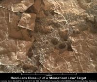
One of the 1668 'Moosehead Lake' focus merged MAHLIs ('Morancy Stream' or 'Sheldrake Island'). Scale bar thanks to Gerald and the focus motor count. Some really nice details in this set of images LINK
|
|
|
|
|
|
 Phil Stooke South to Vera Rubin Ridge Apr 7 2017, 07:24 PM
 Phil Stooke OK, we are on the road, and here is a circular ver... Apr 7 2017, 08:19 PM PaulH51 Mission Update from Ryan Anderson: Sols 1661-1663:... Apr 8 2017, 09:39 PM PaulH51 Not much here really (1662 L-NavCam partial) but i... Apr 10 2017, 10:39 AM fredk DD activity has been quiet recently, but here... Apr 10 2017, 07:23 PM jvandriel The Navcam L view on Sol 1662.
Jan van Driel
Apr 10 2017, 08:40 PM Phil Stooke Thanks, Jan. Here is a circular version. We are ... Apr 10 2017, 09:15 PM PaulH51 Curiosity Rover Mission Update: Sols 1664-1665: Ke... Apr 11 2017, 05:12 AM atomoid ICe stitch of the sol1661 chemcam. i think that se... Apr 12 2017, 03:02 AM
Phil Stooke OK, we are on the road, and here is a circular ver... Apr 7 2017, 08:19 PM PaulH51 Mission Update from Ryan Anderson: Sols 1661-1663:... Apr 8 2017, 09:39 PM PaulH51 Not much here really (1662 L-NavCam partial) but i... Apr 10 2017, 10:39 AM fredk DD activity has been quiet recently, but here... Apr 10 2017, 07:23 PM jvandriel The Navcam L view on Sol 1662.
Jan van Driel
Apr 10 2017, 08:40 PM Phil Stooke Thanks, Jan. Here is a circular version. We are ... Apr 10 2017, 09:15 PM PaulH51 Curiosity Rover Mission Update: Sols 1664-1665: Ke... Apr 11 2017, 05:12 AM atomoid ICe stitch of the sol1661 chemcam. i think that se... Apr 12 2017, 03:02 AM
 PaulH51 QUOTE (atomoid @ Apr 12 2017, 11:02 AM) I... Apr 12 2017, 03:51 AM elakdawalla I don't have time to do this myself, but: take... Apr 12 2017, 04:34 AM PaulH51 QUOTE (elakdawalla @ Apr 12 2017, 12:34 P... Apr 12 2017, 05:39 AM Phil Stooke If there was any move at all it can only have been... Apr 12 2017, 01:08 PM PaulH51 QUOTE (Phil Stooke @ Apr 12 2017, 09:08 P... Apr 12 2017, 01:39 PM jvandriel The Navcam L view on Sol 1664.
Jan van Driel
Apr 12 2017, 08:14 PM PaulH51 Sol 1666: The short drive up to 'Moosehead Lak... Apr 14 2017, 03:06 AM HSchirmer QUOTE (PaulH51 @ Apr 14 2017, 03:06 AM) S... Apr 14 2017, 09:36 PM PaulH51 QUOTE (HSchirmer @ Apr 15 2017, 05:36 AM)... Apr 14 2017, 10:10 PM PaulH51 USGS Mission Update by Ryan Anderson Sols 1668-167... Apr 15 2017, 01:34 AM jvandriel The Navcam L view on Sol 1666.
Jan van Driel
Apr 15 2017, 01:38 PM Phil Stooke Thanks, Jan. Here is a circular view of it. The ... Apr 15 2017, 03:17 PM PaulH51 1666 MS ICE L-MastCam 'arm workspace' with... Apr 16 2017, 02:17 AM PaulH51 A pair of 'colour-boundary' targets dubbed... Apr 16 2017, 11:33 PM PaulH51 And the 1669 drive images all came down in one sho... Apr 17 2017, 08:19 AM Floyd Sand crepes. It looks like the delicates crepe is... Apr 17 2017, 11:42 AM PaulH51 QUOTE (Floyd @ Apr 17 2017, 07:42 PM) San... Apr 17 2017, 12:06 PM Phil Stooke Thanks for the panorama, Paul - here is a circular... Apr 17 2017, 12:09 PM jvandriel Here is my view of the Sol 1669 Panorama.
Jan van... Apr 17 2017, 01:55 PM atomoid crosseyed/parallel version of that deliciously und... Apr 18 2017, 10:38 PM serpens The "crepes" are really quite lovely. I... Apr 19 2017, 02:15 AM Phil Stooke Just a few metres drive on sol 1671.
Phil Apr 19 2017, 12:44 PM jvandriel The Navcam L view on Sol 1671.
Jan van Driel
Apr 20 2017, 08:18 PM PaulH51 1673 Drive: EDIT : 'Curiosity moved approximat... Apr 21 2017, 07:54 AM Phil Stooke An invaluable source of day to day news about Curi... Apr 22 2017, 12:44 AM PaulH51 QUOTE (Phil Stooke @ Apr 22 2017, 08:44 A... Apr 22 2017, 12:50 AM elakdawalla QUOTE (Phil Stooke @ Apr 21 2017, 04:44 P... Apr 24 2017, 04:18 PM PaulH51 Sol 1673 L-MastCam mosaic of the rover's weeke... Apr 22 2017, 11:09 AM jvandriel Thhe Navcam L view on Sol 1672.
Jan van Driel
Apr 22 2017, 02:27 PM jvandriel and the L Navcam view on Sol 1673.
Jan van Driel
... Apr 22 2017, 07:19 PM PaulH51 Another periodic check of the deck mounted Rover E... Apr 24 2017, 03:34 AM PaulH51 Sol 1676 drive of ~26 minutes, partial NavCam pan ... Apr 24 2017, 07:37 AM Phil Stooke Reprojected hazcams for the sol 1676 drive. They ... Apr 24 2017, 12:04 PM PaulH51 QUOTE (Phil Stooke @ Apr 24 2017, 08:04 P... Apr 24 2017, 01:17 PM Phil Stooke Also, the JPL site contains archives all the way b... Apr 24 2017, 04:29 PM Sean Here is a still from a movie I'm cooking up sh... Apr 24 2017, 06:16 PM PaulH51 A short YouTube video 'How To Not Break A Mars... Apr 25 2017, 01:31 AM PaulH51 Drive on sol 1677 : L-NavCam Partial Pan (MS ICE),... Apr 25 2017, 01:19 PM jvandriel The MAHLI view on Sol 1675.
Jan van Driel
Apr 25 2017, 03:02 PM PaulH51 My take on the 1675 MAHLI mosaic, rotated and scal... Apr 26 2017, 02:35 AM PaulH51 Curiosity Rover Total Traverse Passes The 10 Mile ... Apr 26 2017, 03:56 AM PaulH51 Curiosity Rover USGS Mission Update: Sol 1678: A S... Apr 26 2017, 09:11 AM PaulH51 1678 partial pan L-NavCam using MS ICE, will add d... Apr 26 2017, 10:23 AM PaulH51 Sol 1679 L-NavCam partial pan in MS ICE, drive was... Apr 27 2017, 11:36 AM PaulH51 Sol 1678 L-MastCam mosaic (arm workspace) MS-ICE
Apr 27 2017, 12:07 PM jvandriel The complete Navcam L view on Sol 1676.
Jan van D... Apr 27 2017, 07:26 PM jvandriel and the complete one taken on Sol 1677.
Jan van D... Apr 27 2017, 08:17 PM PaulH51 Crocker Mountain? Sol 1678 RMI and R-MastCam monta... Apr 28 2017, 06:49 AM jvandriel The Navcam L view on Sol 1678.
Jan van Driel
Apr 28 2017, 02:13 PM Phil Stooke Here is Jan's latest panorama in circular form... Apr 28 2017, 06:07 PM jvandriel and the view, with missing data, on Sol 1679.
Jan... Apr 28 2017, 08:11 PM Phil Stooke Thanks, Jan - here is a circular view of it (I fil... Apr 30 2017, 01:48 AM jvandriel The complete Navcam L view on Sol 1679.
( Added th... Apr 30 2017, 07:50 PM jvandriel and the view on Sol 1680.
Jan van Driel
Apr 30 2017, 08:43 PM PaulH51 Partial NLB 1683, with a little data drop out. M-P... May 1 2017, 09:25 PM atomoid anaglyph and reduced crosseye of sol1683 navcam pa... May 2 2017, 09:04 PM jvandriel The Navcam L view on Sol 1684.
Jan van Driel
May 3 2017, 09:09 AM PaulH51 Short Drive? Partial NLB 1685 in MS ICE, the missi... May 3 2017, 02:25 PM Phil Stooke Here is your half-panorama in circular form. My m... May 3 2017, 03:49 PM jvandriel The last complete image is down and here is the Na... May 3 2017, 07:41 PM vikingmars Thank you very much jvandriel for this very intere... May 4 2017, 07:04 AM PaulH51 'May the 4th be with your Megaripples...'
... May 4 2017, 02:39 PM jvandriel The Navcam L View on Sol 1685.
Jan van Driel
May 4 2017, 07:33 PM atomoid anaglph and crosseye excerpt of stitches of the ou... May 4 2017, 09:53 PM Phil Stooke This is Jan's 1685 panorama in circular form, ... May 5 2017, 12:04 AM jvandriel The Navcam L view on Sol 1686.
Jan van Driel
May 5 2017, 10:26 AM verfkwast Thanks 4 the great pictures Jan, Paul, Phil, atom ... May 5 2017, 01:28 PM Art Martin I see that we're ascending a hill because the ... May 5 2017, 02:03 PM scalbers QUOTE (Art Martin @ May 5 2017, 02:03 PM)... May 5 2017, 09:59 PM PaulH51 QUOTE (Art Martin @ May 5 2017, 10:03 PM)... May 6 2017, 03:13 AM Art Martin QUOTE (PaulH51 @ May 5 2017, 08:13 PM) Th... May 6 2017, 11:17 PM Phil Stooke Jan's sol 1686 panorama in circular form. Com... May 5 2017, 06:57 PM Art Martin Some 3D from Sol 1686
1686 Ripples Anaglyph 2
16... May 7 2017, 12:38 AM PaulH51 Sol 1682 : A mosaic of focus merged MAHLIs assembl... May 7 2017, 02:24 AM PaulH51 Meagaripple grains, sol 1688 MAHLI,
Edit: One of ... May 7 2017, 10:42 AM PaulH51 Sol 1688: a crop from a mosaic of two R-MastCam fr... May 8 2017, 03:17 AM charborob The complete sol 1688 Rmastcam panorama: May 8 2017, 10:11 AM PaulH51 1690 L-NavCam: Quick & very dirty in MS ICE, b... May 9 2017, 12:52 AM Phil Stooke Paul's panorama in a circular version - I crop... May 9 2017, 01:27 AM jvandriel The Navcam L view on Sol 1690.
Jan van Driel
May 9 2017, 04:56 PM Phil Stooke Sol 1691 - a short drive, just a few metres, south... May 9 2017, 06:29 PM atomoid layer flake stereo of sol1688, presumably one of t... May 9 2017, 08:34 PM fredk QUOTE (atomoid @ May 9 2017, 09:34 PM) th... May 9 2017, 10:10 PM Phil Stooke "I'm not sure what the story is with that... May 9 2017, 10:45 PM Phil Stooke This is Jan's panorama from sol 1690 in circul... May 10 2017, 03:08 AM jvandriel The Navcam L view on Sol 1691.
Jan van Driel
May 10 2017, 11:30 AM PaulH51 One of a series of pre-drive focus merged MAHLI... May 10 2017, 12:04 PM Gerald For the focus-stacked images, the motor count for ... May 10 2017, 02:15 PM PaulH51 QUOTE (Gerald @ May 10 2017, 10:15 PM) I... May 10 2017, 11:05 PM PaulH51 1691 L-MastCam of Curiosity's workspace, assem... May 10 2017, 11:14 PM
PaulH51 QUOTE (atomoid @ Apr 12 2017, 11:02 AM) I... Apr 12 2017, 03:51 AM elakdawalla I don't have time to do this myself, but: take... Apr 12 2017, 04:34 AM PaulH51 QUOTE (elakdawalla @ Apr 12 2017, 12:34 P... Apr 12 2017, 05:39 AM Phil Stooke If there was any move at all it can only have been... Apr 12 2017, 01:08 PM PaulH51 QUOTE (Phil Stooke @ Apr 12 2017, 09:08 P... Apr 12 2017, 01:39 PM jvandriel The Navcam L view on Sol 1664.
Jan van Driel
Apr 12 2017, 08:14 PM PaulH51 Sol 1666: The short drive up to 'Moosehead Lak... Apr 14 2017, 03:06 AM HSchirmer QUOTE (PaulH51 @ Apr 14 2017, 03:06 AM) S... Apr 14 2017, 09:36 PM PaulH51 QUOTE (HSchirmer @ Apr 15 2017, 05:36 AM)... Apr 14 2017, 10:10 PM PaulH51 USGS Mission Update by Ryan Anderson Sols 1668-167... Apr 15 2017, 01:34 AM jvandriel The Navcam L view on Sol 1666.
Jan van Driel
Apr 15 2017, 01:38 PM Phil Stooke Thanks, Jan. Here is a circular view of it. The ... Apr 15 2017, 03:17 PM PaulH51 1666 MS ICE L-MastCam 'arm workspace' with... Apr 16 2017, 02:17 AM PaulH51 A pair of 'colour-boundary' targets dubbed... Apr 16 2017, 11:33 PM PaulH51 And the 1669 drive images all came down in one sho... Apr 17 2017, 08:19 AM Floyd Sand crepes. It looks like the delicates crepe is... Apr 17 2017, 11:42 AM PaulH51 QUOTE (Floyd @ Apr 17 2017, 07:42 PM) San... Apr 17 2017, 12:06 PM Phil Stooke Thanks for the panorama, Paul - here is a circular... Apr 17 2017, 12:09 PM jvandriel Here is my view of the Sol 1669 Panorama.
Jan van... Apr 17 2017, 01:55 PM atomoid crosseyed/parallel version of that deliciously und... Apr 18 2017, 10:38 PM serpens The "crepes" are really quite lovely. I... Apr 19 2017, 02:15 AM Phil Stooke Just a few metres drive on sol 1671.
Phil Apr 19 2017, 12:44 PM jvandriel The Navcam L view on Sol 1671.
Jan van Driel
Apr 20 2017, 08:18 PM PaulH51 1673 Drive: EDIT : 'Curiosity moved approximat... Apr 21 2017, 07:54 AM Phil Stooke An invaluable source of day to day news about Curi... Apr 22 2017, 12:44 AM PaulH51 QUOTE (Phil Stooke @ Apr 22 2017, 08:44 A... Apr 22 2017, 12:50 AM elakdawalla QUOTE (Phil Stooke @ Apr 21 2017, 04:44 P... Apr 24 2017, 04:18 PM PaulH51 Sol 1673 L-MastCam mosaic of the rover's weeke... Apr 22 2017, 11:09 AM jvandriel Thhe Navcam L view on Sol 1672.
Jan van Driel
Apr 22 2017, 02:27 PM jvandriel and the L Navcam view on Sol 1673.
Jan van Driel
... Apr 22 2017, 07:19 PM PaulH51 Another periodic check of the deck mounted Rover E... Apr 24 2017, 03:34 AM PaulH51 Sol 1676 drive of ~26 minutes, partial NavCam pan ... Apr 24 2017, 07:37 AM Phil Stooke Reprojected hazcams for the sol 1676 drive. They ... Apr 24 2017, 12:04 PM PaulH51 QUOTE (Phil Stooke @ Apr 24 2017, 08:04 P... Apr 24 2017, 01:17 PM Phil Stooke Also, the JPL site contains archives all the way b... Apr 24 2017, 04:29 PM Sean Here is a still from a movie I'm cooking up sh... Apr 24 2017, 06:16 PM PaulH51 A short YouTube video 'How To Not Break A Mars... Apr 25 2017, 01:31 AM PaulH51 Drive on sol 1677 : L-NavCam Partial Pan (MS ICE),... Apr 25 2017, 01:19 PM jvandriel The MAHLI view on Sol 1675.
Jan van Driel
Apr 25 2017, 03:02 PM PaulH51 My take on the 1675 MAHLI mosaic, rotated and scal... Apr 26 2017, 02:35 AM PaulH51 Curiosity Rover Total Traverse Passes The 10 Mile ... Apr 26 2017, 03:56 AM PaulH51 Curiosity Rover USGS Mission Update: Sol 1678: A S... Apr 26 2017, 09:11 AM PaulH51 1678 partial pan L-NavCam using MS ICE, will add d... Apr 26 2017, 10:23 AM PaulH51 Sol 1679 L-NavCam partial pan in MS ICE, drive was... Apr 27 2017, 11:36 AM PaulH51 Sol 1678 L-MastCam mosaic (arm workspace) MS-ICE
Apr 27 2017, 12:07 PM jvandriel The complete Navcam L view on Sol 1676.
Jan van D... Apr 27 2017, 07:26 PM jvandriel and the complete one taken on Sol 1677.
Jan van D... Apr 27 2017, 08:17 PM PaulH51 Crocker Mountain? Sol 1678 RMI and R-MastCam monta... Apr 28 2017, 06:49 AM jvandriel The Navcam L view on Sol 1678.
Jan van Driel
Apr 28 2017, 02:13 PM Phil Stooke Here is Jan's latest panorama in circular form... Apr 28 2017, 06:07 PM jvandriel and the view, with missing data, on Sol 1679.
Jan... Apr 28 2017, 08:11 PM Phil Stooke Thanks, Jan - here is a circular view of it (I fil... Apr 30 2017, 01:48 AM jvandriel The complete Navcam L view on Sol 1679.
( Added th... Apr 30 2017, 07:50 PM jvandriel and the view on Sol 1680.
Jan van Driel
Apr 30 2017, 08:43 PM PaulH51 Partial NLB 1683, with a little data drop out. M-P... May 1 2017, 09:25 PM atomoid anaglyph and reduced crosseye of sol1683 navcam pa... May 2 2017, 09:04 PM jvandriel The Navcam L view on Sol 1684.
Jan van Driel
May 3 2017, 09:09 AM PaulH51 Short Drive? Partial NLB 1685 in MS ICE, the missi... May 3 2017, 02:25 PM Phil Stooke Here is your half-panorama in circular form. My m... May 3 2017, 03:49 PM jvandriel The last complete image is down and here is the Na... May 3 2017, 07:41 PM vikingmars Thank you very much jvandriel for this very intere... May 4 2017, 07:04 AM PaulH51 'May the 4th be with your Megaripples...'
... May 4 2017, 02:39 PM jvandriel The Navcam L View on Sol 1685.
Jan van Driel
May 4 2017, 07:33 PM atomoid anaglph and crosseye excerpt of stitches of the ou... May 4 2017, 09:53 PM Phil Stooke This is Jan's 1685 panorama in circular form, ... May 5 2017, 12:04 AM jvandriel The Navcam L view on Sol 1686.
Jan van Driel
May 5 2017, 10:26 AM verfkwast Thanks 4 the great pictures Jan, Paul, Phil, atom ... May 5 2017, 01:28 PM Art Martin I see that we're ascending a hill because the ... May 5 2017, 02:03 PM scalbers QUOTE (Art Martin @ May 5 2017, 02:03 PM)... May 5 2017, 09:59 PM PaulH51 QUOTE (Art Martin @ May 5 2017, 10:03 PM)... May 6 2017, 03:13 AM Art Martin QUOTE (PaulH51 @ May 5 2017, 08:13 PM) Th... May 6 2017, 11:17 PM Phil Stooke Jan's sol 1686 panorama in circular form. Com... May 5 2017, 06:57 PM Art Martin Some 3D from Sol 1686
1686 Ripples Anaglyph 2
16... May 7 2017, 12:38 AM PaulH51 Sol 1682 : A mosaic of focus merged MAHLIs assembl... May 7 2017, 02:24 AM PaulH51 Meagaripple grains, sol 1688 MAHLI,
Edit: One of ... May 7 2017, 10:42 AM PaulH51 Sol 1688: a crop from a mosaic of two R-MastCam fr... May 8 2017, 03:17 AM charborob The complete sol 1688 Rmastcam panorama: May 8 2017, 10:11 AM PaulH51 1690 L-NavCam: Quick & very dirty in MS ICE, b... May 9 2017, 12:52 AM Phil Stooke Paul's panorama in a circular version - I crop... May 9 2017, 01:27 AM jvandriel The Navcam L view on Sol 1690.
Jan van Driel
May 9 2017, 04:56 PM Phil Stooke Sol 1691 - a short drive, just a few metres, south... May 9 2017, 06:29 PM atomoid layer flake stereo of sol1688, presumably one of t... May 9 2017, 08:34 PM fredk QUOTE (atomoid @ May 9 2017, 09:34 PM) th... May 9 2017, 10:10 PM Phil Stooke "I'm not sure what the story is with that... May 9 2017, 10:45 PM Phil Stooke This is Jan's panorama from sol 1690 in circul... May 10 2017, 03:08 AM jvandriel The Navcam L view on Sol 1691.
Jan van Driel
May 10 2017, 11:30 AM PaulH51 One of a series of pre-drive focus merged MAHLI... May 10 2017, 12:04 PM Gerald For the focus-stacked images, the motor count for ... May 10 2017, 02:15 PM PaulH51 QUOTE (Gerald @ May 10 2017, 10:15 PM) I... May 10 2017, 11:05 PM PaulH51 1691 L-MastCam of Curiosity's workspace, assem... May 10 2017, 11:14 PM |

|
Lo-Fi Version | Time is now: 25th September 2024 - 07:55 AM |
|
RULES AND GUIDELINES Please read the Forum Rules and Guidelines before posting. IMAGE COPYRIGHT |
OPINIONS AND MODERATION Opinions expressed on UnmannedSpaceflight.com are those of the individual posters and do not necessarily reflect the opinions of UnmannedSpaceflight.com or The Planetary Society. The all-volunteer UnmannedSpaceflight.com moderation team is wholly independent of The Planetary Society. The Planetary Society has no influence over decisions made by the UnmannedSpaceflight.com moderators. |
SUPPORT THE FORUM Unmannedspaceflight.com is funded by the Planetary Society. Please consider supporting our work and many other projects by donating to the Society or becoming a member. |
|