Juno perijove 6, May 19, 2017 |

Juno perijove 6, May 19, 2017 |
 May 4 2017, 05:57 PM May 4 2017, 05:57 PM
Post
#1
|
|
|
Senior Member  Group: Members Posts: 2346 Joined: 7-December 12 Member No.: 6780 |
Voting for Perijove 06 started yesterday, and it will last for another almost 7 days.
This time, I'm not quite free of bias, since I'm interested in an extension of the polar time-lapse sequence, especially in a coverage of the north and south polar FFRs and the presumed edge of the respective polar haze disks. I think - well, I'm rather certain - that it's possible to infer short-time dynamics of the FFRs, and of the vortices near the edge of the haze disk. Due to the expected good contact to Earth during the PJ-6 pass we have a good chance to obtain overlapping images of these regions. More in the discussion section on the missionjuno site. Of course, there are other interesting targets, too; see Glenn's and John Rogers' (Philosophia-47) comments. A full latitude coverage would allow for a pole-to-pole animation. |
 |
 
|
 |
|
May 25 2017, 05:14 PM
Post
#2
|
|||
 IMG to PNG GOD Group: Moderator Posts: 2254 Joined: 19-February 04 From: Near fire and ice Member No.: 38 |
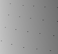
As I mentioned previously, these latest JunoCam images are awesome. I took a fairly detailed look at one of the images I posted earlier with particular attention to cloud elevation differences. First an unusual image. This is a perfectly flat DEM with several spikes - their shadows show the direction of sunlight in one of the JunoCam images I posted earlier:
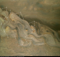
And here is the corresponding JunoCam image. This is one of the images I posted earlier but here I have added some annotations:
A. Bright, high altitude clouds that usually seem to be isolated or to occur in small clusters. B. These clouds are similar to (A) in color and altitude. But unlike (A) they appear elongated, probably parallel to the wind direction. At least in some cases they indicate high wind speeds - clouds like these are visible at lower resolution in Voyager images showing the northeast periphery of the Great Red Spot where the wind speed is very high. C. I suspect that here we are seeing the darker and lower cloud deck through tenuous and mostly transparent high altitude clouds. This is more obvious when looking at the red channel only. D and E. Here JunoCam may have directly observed/imaged the elevation difference between the dark clouds and the less dark clouds south of the 'color/brightness transition'. Areas indicated by (D) appear slightly darker than areas indicated by (E). When taking into account the direction of the shadows in the DEM/spike shadow render above, the areas indicated by (D) may be in shadow caused by the brighter clouds south of the brightness/color transitions while the areas indicated by (E) are not in shadow. F. These clouds seem somewhat similar to (A) but they occur in far bigger clusters. Apparently they also might be at a slightly lower altitude - this is not obvious though. G. Possible shadows hinting at elevation differences but color/brightness variations are also a possibility. Features like this are very common. |
||
|
|
|
||
|
May 25 2017, 09:54 PM
Post
#3
|
||
|
Member Group: Members Posts: 306 Joined: 4-October 14 Member No.: 7273 |
QUOTE (Bjorn Jonsson @ May 25 2017, 11:14 AM)  And here is the corresponding JunoCam image. This is one of the images I posted earlier but here I have added some annotations:
A. Bright, high altitude clouds that usually seem to be isolated or to occur in small clusters. B. These clouds are similar to (A) in color and altitude. But unlike (A) they appear elongated, probably parallel to the wind direction. At least in some cases they indicate high wind speeds - clouds like these are visible at lower resolution in Voyager images showing the northeast periphery of the Great Red Spot where the wind speed is very high. C. I suspect that here we are seeing the darker and lower cloud deck through tenuous and mostly transparent high altitude clouds. This is more obvious when looking at the red channel only. D and E. Here JunoCam may have directly observed/imaged the elevation difference between the dark clouds and the less dark clouds south of the 'color/brightness transition'. Areas indicated by (D) appear slightly darker than areas indicated by (E). When taking into account the direction of the shadows in the DEM/spike shadow render above, the areas indicated by (D) may be in shadow caused by the brighter clouds south of the brightness/color transitions while the areas indicated by (E) are not in shadow. F. These clouds seem somewhat similar to (A) but they occur in far bigger clusters. Apparently they also might be at a slightly lower altitude - this is not obvious though. G. Possible shadows hinting at elevation differences but color/brightness variations are also a possibility. Features like this are very common. Going to make some interested-layman interpretations of the meteorology here. One observation is that the two largest A-type clouds seem to be found at eddy inflection points, right where the white clouds meet the brown clouds. I wonder if these might be supercell-like convective systems that are popping up along the boundary of white and brown clouds, and whose development is aided by favorable upper level conditions created by air diverging as it rounds the inflection point of the eddy. F-type clouds seem to be more embedded within the local flow and are vaguely oriented in "streets" parallel to the flow direction. These are kind of reminiscent of the cloud streets that tend to form in the dry slot of a mature low-pressure system, or in clusters of multicell convection in strong upper level wind regimes where the updrafts tend to form trains. B-type clouds look like cirrus streaks formed getting blown off the tops of the more intense convective clouds, and if you look closely at the A-type cloud clusters near the center of the image, you can see some of these streaks beginning to form as elongated cloudtops on individual convective cells. Maybe a more clear example of what Bjorn is getting at with point C can be seen just to the right of the F at left center. There is an extremely dark brown cloud rotating around the top of the eddy that has an apparently sharp edge, but if you look closely you can see that it continues underneath the lighter clouds. (Not at a computer where I can highlight this but if anyone is having issues seeing what I'm talking about I'll try to have something up within a day) |
|
|
|
|
|
 Gerald Juno perijove 6 May 4 2017, 05:57 PM
 mcaplinger Part of the PJ6 dataset has been posted to mission... May 19 2017, 09:28 PM Gerald Here PJ06 images #109, #110, and #111, in a prelim... May 20 2017, 05:47 PM Gerald Another 5 PJ06 images split into 2 posts for uploa... May 21 2017, 01:15 AM Gerald
The target names in the order of the images:
JN... May 21 2017, 01:26 AM xflare Looks like there are hundreds of individual storm ... May 21 2017, 09:36 AM Gerald Large version (30 pixels per cylindrical camera de... May 21 2017, 05:40 PM scalbers New wonders to behold on Jupiter. I like this sect... May 21 2017, 07:14 PM Sean Gerald's excellent work with some processing t... May 21 2017, 08:56 PM Sean After NASA / SwRI / MSSS / Gerald Eichstädt
Image... May 22 2017, 12:59 PM Sean Last one... my favourite image from the latest seq... May 22 2017, 04:53 PM
mcaplinger Part of the PJ6 dataset has been posted to mission... May 19 2017, 09:28 PM Gerald Here PJ06 images #109, #110, and #111, in a prelim... May 20 2017, 05:47 PM Gerald Another 5 PJ06 images split into 2 posts for uploa... May 21 2017, 01:15 AM Gerald
The target names in the order of the images:
JN... May 21 2017, 01:26 AM xflare Looks like there are hundreds of individual storm ... May 21 2017, 09:36 AM Gerald Large version (30 pixels per cylindrical camera de... May 21 2017, 05:40 PM scalbers New wonders to behold on Jupiter. I like this sect... May 21 2017, 07:14 PM Sean Gerald's excellent work with some processing t... May 21 2017, 08:56 PM Sean After NASA / SwRI / MSSS / Gerald Eichstädt
Image... May 22 2017, 12:59 PM Sean Last one... my favourite image from the latest seq... May 22 2017, 04:53 PM mcaplinger QUOTE (Sean @ May 22 2017, 08:53 AM) Last... May 22 2017, 05:46 PM
 JRehling That's great, Sean. It almost induces vertigo,... May 22 2017, 05:51 PM Sean Thanks but all credit to Gerald for the work he ha... May 22 2017, 06:25 PM Gerald QUOTE (Sean @ May 22 2017, 08:25 PM) Than... May 22 2017, 08:44 PM jccwrt I tried my hand at processing some of Gerald's... May 22 2017, 11:56 PM Explorer1 First science result press conference on Thursday ... May 23 2017, 12:57 AM mcaplinger Everyone who's processed images from PJ6 (Sean... May 23 2017, 03:23 AM jccwrt QUOTE (mcaplinger @ May 22 2017, 10:23 PM... May 23 2017, 02:51 PM Gerald Most of the remaining PJ06 close-up raws are on th... May 23 2017, 08:39 AM Ant103 Hi
Those Junocam pictures processed by you, Gera... May 23 2017, 11:30 AM Sean I've started uploading to the Mission Juno sit... May 23 2017, 01:53 PM Sean Another portrait from Gerald's latest...
Ju... May 23 2017, 03:06 PM Sean A third portrait from Gerald's latest...
De... May 23 2017, 04:51 PM The Singing Badger These images are absolutely incredible. It's a... May 23 2017, 05:21 PM Sean Thanks Badger!
Here is the last one for toda... May 23 2017, 06:57 PM GS_Brazil QUOTE (The Singing Badger @ May 23 2017, 02... May 23 2017, 10:52 PM Sean PJ06 sequence
Added a couple more shots to fill... May 23 2017, 11:36 PM belleraphon1 These are phenomenal.... really feel I am seeing t... May 24 2017, 12:26 AM jccwrt Here's my effort at processing image #123 usin... May 24 2017, 02:28 AM Ron Hobbs AWESOME!!! May 24 2017, 02:37 AM Sean PJ06 cloud detail May 24 2017, 10:40 AM antipode I cant believe Junocam was an 'add-on'. Th... May 24 2017, 11:53 AM GS_Brazil QUOTE (antipode @ May 24 2017, 08:53 AM) ... May 24 2017, 12:38 PM mcaplinger QUOTE (GS_Brazil @ May 24 2017, 04:38 AM)... May 24 2017, 03:45 PM Sean I will be sure to include that info for the next b... May 24 2017, 04:32 PM mcaplinger QUOTE (Sean @ May 24 2017, 08:32 AM) I wa... May 24 2017, 06:21 PM Gerald QUOTE (mcaplinger @ May 24 2017, 08:21 PM... May 24 2017, 08:35 PM mcaplinger QUOTE (GS_Brazil @ May 24 2017, 04:38 AM)... May 24 2017, 06:50 PM ChrisC QUOTE (GS_Brazil @ May 24 2017, 07:38 AM)... May 27 2017, 04:07 AM Gerald For the images on the junocam.picture site, I... May 24 2017, 05:57 PM Sean Since working with this data I have refined my pro... May 24 2017, 07:40 PM Sean I would love to have a go at processing the P06 an... May 24 2017, 09:40 PM jccwrt Processed image #117, centered over the southern e... May 24 2017, 10:39 PM Bjorn Jonsson I never thought I'd say this about any of the ... May 25 2017, 12:51 AM Explorer1 Astounding work, Bjorn (and everyone else!). S... May 25 2017, 02:25 AM J.J. Can only echo thanks to the Juno team and to every... May 25 2017, 03:49 AM Sean I have updated the following portrait from Perijov... May 25 2017, 03:22 PM scalbers Superb image processing and analysis. Great to see... May 25 2017, 05:33 PM Bjorn Jonsson QUOTE (scalbers @ May 25 2017, 05:33 PM) ... May 28 2017, 04:25 PM Gerald For completeness, a few hours ago I've uploade... May 25 2017, 07:47 PM Gerald PJ-06 flyby movie, first release:
- on youtube
- A... May 25 2017, 10:09 PM Sean Another updated portrait...
Details... May 26 2017, 03:43 AM Candy Hansen These are simply heart-stopping beautiful! Th... May 30 2017, 10:07 PM Gerald Stills of PJ06 flyby animation, zipped:
- Part 12
... May 26 2017, 04:11 AM Sean Here is a preview of the sequence Gerald shared...... May 26 2017, 01:27 PM Gerald QUOTE (Sean @ May 26 2017, 03:27 PM) Here... May 28 2017, 07:26 PM stevesliva The seeming relief-- maybe call it drop shadowing-... May 29 2017, 06:30 PM Sean Here is the full sequence of Perijove 06 based on ... May 30 2017, 05:45 AM Gerald QUOTE (Sean @ May 30 2017, 07:45 AM) ... ... May 31 2017, 05:51 PM Sean Thanks Gerald.
I started looking at the cylindric... May 31 2017, 08:06 PM Gerald QUOTE (Sean @ May 31 2017, 10:06 PM) I st... Jun 2 2017, 12:10 AM Sean 125 Megapixel upscaled & refreshed Print portr... May 30 2017, 07:06 PM Gerald Candy, I'm glad, that with PJ6 we've been ... May 31 2017, 08:07 AM Sean I would like to reiterate what Gerald said, as wel... May 31 2017, 10:41 AM Bjorn Jonsson QUOTE (Sean @ May 31 2017, 10:41 AM) Now,... May 31 2017, 11:12 PM antipode Sean
I assume this is your work?
https://www.you... Jun 2 2017, 02:07 AM JRehling Sean, the video is amazing, and it looks like ther... Jun 2 2017, 02:42 PM Sean Much appreciated Gerald. I've also started loo... Jun 2 2017, 09:32 AM PFK QUOTE (Sean @ Jun 2 2017, 10:32 AM) Thank... Jun 3 2017, 08:40 AM Gerald Seán, Charley Locke just notified, that she comple... Jun 2 2017, 03:08 PM JRehling QUOTE (Gerald @ Jun 2 2017, 08:08 AM) Reg... Jun 4 2017, 12:17 AM Gerald QUOTE (JRehling @ Jun 4 2017, 02:17 AM) I... Jun 4 2017, 06:34 AM Sean @JRehling Thanks, I would be careful about reading... Jun 2 2017, 03:24 PM Gerald I've terabytes of processed JunoCam images, bu... Jun 2 2017, 04:17 PM avisolo QUOTE (Gerald @ Jun 2 2017, 04:17 PM) I... Jun 3 2017, 01:06 AM Gerald Very nice, avisolo! I knew, that there are peo... Jun 3 2017, 01:33 AM avisolo QUOTE (Gerald @ Jun 3 2017, 01:33 AM) Ver... Jun 4 2017, 04:17 PM Sean @PFK... It's been a fascinating online discuss... Jun 3 2017, 10:51 AM avisolo QUOTE (Sean @ Jun 3 2017, 10:51 AM) @PFK.... Jun 3 2017, 12:46 PM Sean Here is an update on processing Gerald's anima... Jun 7 2017, 10:15 AM Sean An update on the PJ06 sequence... Jun 7 2017, 11:21 AM Gerald Finally, I found some time to process drafts of th... Jun 7 2017, 11:49 AM Sean Some new processing on clouds... Jun 7 2017, 12:59 PM Sean Can someone explain this rippled feature I culled ... Jun 7 2017, 01:12 PM Gerald That's structures in Jupiter's haze layer,... Jun 7 2017, 01:34 PM Gerald Here is an extended, kind, and interesting intervi... Jun 7 2017, 07:55 PM Sean More clouds from Geralds PJ06_112... Jun 8 2017, 04:26 PM Bjorn Jonsson Awesome stuff, image-wise this is one of the most ... Jun 8 2017, 09:03 PM charborob Good idea. However, the 1MB limit on file size may... Jun 8 2017, 09:44 PM Phil Stooke I would encourage all of you who are doing this gr... Jun 8 2017, 10:55 PM Gerald At least some of the Jupiter images are already in... Jun 9 2017, 09:54 AM Bjorn Jonsson Here are my versions of the PJ-6 111 image (... Jun 9 2017, 09:21 PM Gerald I thought, I should post this rendition of PJ06#92... Jun 9 2017, 11:39 PM Sean More from Gerald's PJ06 work...
PJ06_110
PJ... Jun 9 2017, 11:47 PM Gerald This is a crop of an enhanced version of PJ06#133 ... Jun 10 2017, 01:31 AM Floyd Thank you Gerald and Sean and others who process a... Jun 10 2017, 01:24 PM Gerald Here the 2-fold supersampled reprojections I annou... Jun 10 2017, 03:15 PM
JRehling That's great, Sean. It almost induces vertigo,... May 22 2017, 05:51 PM Sean Thanks but all credit to Gerald for the work he ha... May 22 2017, 06:25 PM Gerald QUOTE (Sean @ May 22 2017, 08:25 PM) Than... May 22 2017, 08:44 PM jccwrt I tried my hand at processing some of Gerald's... May 22 2017, 11:56 PM Explorer1 First science result press conference on Thursday ... May 23 2017, 12:57 AM mcaplinger Everyone who's processed images from PJ6 (Sean... May 23 2017, 03:23 AM jccwrt QUOTE (mcaplinger @ May 22 2017, 10:23 PM... May 23 2017, 02:51 PM Gerald Most of the remaining PJ06 close-up raws are on th... May 23 2017, 08:39 AM Ant103 Hi
Those Junocam pictures processed by you, Gera... May 23 2017, 11:30 AM Sean I've started uploading to the Mission Juno sit... May 23 2017, 01:53 PM Sean Another portrait from Gerald's latest...
Ju... May 23 2017, 03:06 PM Sean A third portrait from Gerald's latest...
De... May 23 2017, 04:51 PM The Singing Badger These images are absolutely incredible. It's a... May 23 2017, 05:21 PM Sean Thanks Badger!
Here is the last one for toda... May 23 2017, 06:57 PM GS_Brazil QUOTE (The Singing Badger @ May 23 2017, 02... May 23 2017, 10:52 PM Sean PJ06 sequence
Added a couple more shots to fill... May 23 2017, 11:36 PM belleraphon1 These are phenomenal.... really feel I am seeing t... May 24 2017, 12:26 AM jccwrt Here's my effort at processing image #123 usin... May 24 2017, 02:28 AM Ron Hobbs AWESOME!!! May 24 2017, 02:37 AM Sean PJ06 cloud detail May 24 2017, 10:40 AM antipode I cant believe Junocam was an 'add-on'. Th... May 24 2017, 11:53 AM GS_Brazil QUOTE (antipode @ May 24 2017, 08:53 AM) ... May 24 2017, 12:38 PM mcaplinger QUOTE (GS_Brazil @ May 24 2017, 04:38 AM)... May 24 2017, 03:45 PM Sean I will be sure to include that info for the next b... May 24 2017, 04:32 PM mcaplinger QUOTE (Sean @ May 24 2017, 08:32 AM) I wa... May 24 2017, 06:21 PM Gerald QUOTE (mcaplinger @ May 24 2017, 08:21 PM... May 24 2017, 08:35 PM mcaplinger QUOTE (GS_Brazil @ May 24 2017, 04:38 AM)... May 24 2017, 06:50 PM ChrisC QUOTE (GS_Brazil @ May 24 2017, 07:38 AM)... May 27 2017, 04:07 AM Gerald For the images on the junocam.picture site, I... May 24 2017, 05:57 PM Sean Since working with this data I have refined my pro... May 24 2017, 07:40 PM Sean I would love to have a go at processing the P06 an... May 24 2017, 09:40 PM jccwrt Processed image #117, centered over the southern e... May 24 2017, 10:39 PM Bjorn Jonsson I never thought I'd say this about any of the ... May 25 2017, 12:51 AM Explorer1 Astounding work, Bjorn (and everyone else!). S... May 25 2017, 02:25 AM J.J. Can only echo thanks to the Juno team and to every... May 25 2017, 03:49 AM Sean I have updated the following portrait from Perijov... May 25 2017, 03:22 PM scalbers Superb image processing and analysis. Great to see... May 25 2017, 05:33 PM Bjorn Jonsson QUOTE (scalbers @ May 25 2017, 05:33 PM) ... May 28 2017, 04:25 PM Gerald For completeness, a few hours ago I've uploade... May 25 2017, 07:47 PM Gerald PJ-06 flyby movie, first release:
- on youtube
- A... May 25 2017, 10:09 PM Sean Another updated portrait...
Details... May 26 2017, 03:43 AM Candy Hansen These are simply heart-stopping beautiful! Th... May 30 2017, 10:07 PM Gerald Stills of PJ06 flyby animation, zipped:
- Part 12
... May 26 2017, 04:11 AM Sean Here is a preview of the sequence Gerald shared...... May 26 2017, 01:27 PM Gerald QUOTE (Sean @ May 26 2017, 03:27 PM) Here... May 28 2017, 07:26 PM stevesliva The seeming relief-- maybe call it drop shadowing-... May 29 2017, 06:30 PM Sean Here is the full sequence of Perijove 06 based on ... May 30 2017, 05:45 AM Gerald QUOTE (Sean @ May 30 2017, 07:45 AM) ... ... May 31 2017, 05:51 PM Sean Thanks Gerald.
I started looking at the cylindric... May 31 2017, 08:06 PM Gerald QUOTE (Sean @ May 31 2017, 10:06 PM) I st... Jun 2 2017, 12:10 AM Sean 125 Megapixel upscaled & refreshed Print portr... May 30 2017, 07:06 PM Gerald Candy, I'm glad, that with PJ6 we've been ... May 31 2017, 08:07 AM Sean I would like to reiterate what Gerald said, as wel... May 31 2017, 10:41 AM Bjorn Jonsson QUOTE (Sean @ May 31 2017, 10:41 AM) Now,... May 31 2017, 11:12 PM antipode Sean
I assume this is your work?
https://www.you... Jun 2 2017, 02:07 AM JRehling Sean, the video is amazing, and it looks like ther... Jun 2 2017, 02:42 PM Sean Much appreciated Gerald. I've also started loo... Jun 2 2017, 09:32 AM PFK QUOTE (Sean @ Jun 2 2017, 10:32 AM) Thank... Jun 3 2017, 08:40 AM Gerald Seán, Charley Locke just notified, that she comple... Jun 2 2017, 03:08 PM JRehling QUOTE (Gerald @ Jun 2 2017, 08:08 AM) Reg... Jun 4 2017, 12:17 AM Gerald QUOTE (JRehling @ Jun 4 2017, 02:17 AM) I... Jun 4 2017, 06:34 AM Sean @JRehling Thanks, I would be careful about reading... Jun 2 2017, 03:24 PM Gerald I've terabytes of processed JunoCam images, bu... Jun 2 2017, 04:17 PM avisolo QUOTE (Gerald @ Jun 2 2017, 04:17 PM) I... Jun 3 2017, 01:06 AM Gerald Very nice, avisolo! I knew, that there are peo... Jun 3 2017, 01:33 AM avisolo QUOTE (Gerald @ Jun 3 2017, 01:33 AM) Ver... Jun 4 2017, 04:17 PM Sean @PFK... It's been a fascinating online discuss... Jun 3 2017, 10:51 AM avisolo QUOTE (Sean @ Jun 3 2017, 10:51 AM) @PFK.... Jun 3 2017, 12:46 PM Sean Here is an update on processing Gerald's anima... Jun 7 2017, 10:15 AM Sean An update on the PJ06 sequence... Jun 7 2017, 11:21 AM Gerald Finally, I found some time to process drafts of th... Jun 7 2017, 11:49 AM Sean Some new processing on clouds... Jun 7 2017, 12:59 PM Sean Can someone explain this rippled feature I culled ... Jun 7 2017, 01:12 PM Gerald That's structures in Jupiter's haze layer,... Jun 7 2017, 01:34 PM Gerald Here is an extended, kind, and interesting intervi... Jun 7 2017, 07:55 PM Sean More clouds from Geralds PJ06_112... Jun 8 2017, 04:26 PM Bjorn Jonsson Awesome stuff, image-wise this is one of the most ... Jun 8 2017, 09:03 PM charborob Good idea. However, the 1MB limit on file size may... Jun 8 2017, 09:44 PM Phil Stooke I would encourage all of you who are doing this gr... Jun 8 2017, 10:55 PM Gerald At least some of the Jupiter images are already in... Jun 9 2017, 09:54 AM Bjorn Jonsson Here are my versions of the PJ-6 111 image (... Jun 9 2017, 09:21 PM Gerald I thought, I should post this rendition of PJ06#92... Jun 9 2017, 11:39 PM Sean More from Gerald's PJ06 work...
PJ06_110
PJ... Jun 9 2017, 11:47 PM Gerald This is a crop of an enhanced version of PJ06#133 ... Jun 10 2017, 01:31 AM Floyd Thank you Gerald and Sean and others who process a... Jun 10 2017, 01:24 PM Gerald Here the 2-fold supersampled reprojections I annou... Jun 10 2017, 03:15 PM |

|
Lo-Fi Version | Time is now: 22nd September 2024 - 02:45 AM |
|
RULES AND GUIDELINES Please read the Forum Rules and Guidelines before posting. IMAGE COPYRIGHT |
OPINIONS AND MODERATION Opinions expressed on UnmannedSpaceflight.com are those of the individual posters and do not necessarily reflect the opinions of UnmannedSpaceflight.com or The Planetary Society. The all-volunteer UnmannedSpaceflight.com moderation team is wholly independent of The Planetary Society. The Planetary Society has no influence over decisions made by the UnmannedSpaceflight.com moderators. |
SUPPORT THE FORUM Unmannedspaceflight.com is funded by the Planetary Society. Please consider supporting our work and many other projects by donating to the Society or becoming a member. |
|