Juno perijove 7: GRS images, July 11, 2017 |

Juno perijove 7: GRS images, July 11, 2017 |
 Jun 30 2017, 12:38 PM Jun 30 2017, 12:38 PM
Post
#1
|
|
|
Senior Member  Group: Members Posts: 2346 Joined: 7-December 12 Member No.: 6780 |
There are another three days left over to vote for Perijove-07 points of interest (POI).
This time, all eyes will be on the Great Red Spot (GRS). Provided everything works as scheduled, one RGB image will be made almost above the center of the GRS. I'd think, that this RGB image will be complemented by a methane image. Since this time, we won't have contact with Earth during the flyby, the amount of data to be collected is rather constraint. Therefore, only a small number of images of the polar region is scheduled, just enough for a long-term observation. Storage will be sufficient for imaging several POIs to be voted for, but we may not get a full latitudinal coverage. In order to obtain a full latitudinal coverage of the GRS and adjacent regions, we should take at least one image near the northern and one image near the southern edge of the GRS, better a set of five RGB images. We would see the GRS from different angles, and we would be able to study the turbulence north and south of the GRS. I'd also expect, that only images from north and south of the GRS will be able to cover most of its longitudinal extent. In addition, a sequence of images near the GRS would provide the raw material for a great and unprecedented fly-over movie. That said, there are several other interesting or potentially interesting targets to consider. Besides for an adjacent region of the GRS, I voted for the two polar-most POIs, since I hope, that we'll get some additional polar and subpolar images for a long-term study, and more close-ups of those incredibly turbulent FFR zones near the poles. |
 |
 
|
 |
|
Jul 14 2017, 02:11 PM
Post
#2
|
|
|
Member Group: Members Posts: 923 Joined: 10-November 15 Member No.: 7837 |
Thanks. I have updated the post & hope this is closer to the reality for now... apologies for the error.
 I will update again once the sums are done. -------------------- |
|
|
|
|
Jul 14 2017, 04:17 PM
Post
#3
|
||
|
Senior Member Group: Members Posts: 2542 Joined: 13-September 05 Member No.: 497 |
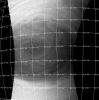
QUOTE (Sean @ Jul 14 2017, 06:11 AM)  I will update again once the sums are done. In PJ7-0060 the east-west limb-to-limb view centered on the GRS covers about 10 degrees of longitude and the north-south extent of the GRS is about 10 degrees of latitude. See attached grid image (I apologize for this ugly figure, I don't have any good tools to make publication-quality grids.) The scale on Jupiter is pi*2*70000/360 = 1222 km/degree roughly (using 70000 for the radius and ignoring oblateness). Longitudes have to be multiplied by cos(lat) but that's not a big effect at the latitude of the GRS (cos(22) is 0.93). So in this image, the GRS is about 12000 km in vertical extent. That's just about the diameter of the Earth, so your revised image looks about right. Note that the GRS has been shrinking over time, so there are all kinds of estimates for how big it is on the Web, and I wouldn't trust most of them. See http://www.lpi.usra.edu/opag/july2014/pres...-Simon_OPAG.pdf but that's from 2014.
-------------------- Disclaimer: This post is based on public information only. Any opinions are my own.
|
|
|
|
|
|
 Gerald Juno perijove 7: GRS images Jun 30 2017, 12:38 PM
 PhilipTerryGraham Presenting, the fancy commemorative logo I made fo... Jul 1 2017, 01:55 PM Candy Hansen We have scheduled 3 GRS images - one that will cap... Jul 6 2017, 06:58 PM nprev All right, all you image wizards...here's a pe... Jul 7 2017, 01:14 AM Candy Hansen I am such a newbie I started a new topic, when I i... Jul 7 2017, 04:39 PM Roman Tkachenko Can't wait for new images!
While we wait f... Jul 7 2017, 10:50 PM t_oner Would we have a GRS floyover with the original orb... Jul 9 2017, 02:38 PM
PhilipTerryGraham Presenting, the fancy commemorative logo I made fo... Jul 1 2017, 01:55 PM Candy Hansen We have scheduled 3 GRS images - one that will cap... Jul 6 2017, 06:58 PM nprev All right, all you image wizards...here's a pe... Jul 7 2017, 01:14 AM Candy Hansen I am such a newbie I started a new topic, when I i... Jul 7 2017, 04:39 PM Roman Tkachenko Can't wait for new images!
While we wait f... Jul 7 2017, 10:50 PM t_oner Would we have a GRS floyover with the original orb... Jul 9 2017, 02:38 PM
 mcaplinger QUOTE (t_oner @ Jul 9 2017, 06:38 AM) Wou... Jul 11 2017, 04:22 AM PhilipTerryGraham QUOTE (mcaplinger @ Jul 11 2017, 02:22 PM... Jul 11 2017, 04:37 AM Sean Using Bjorn's Voyager mosaic for this comp...
... Jul 10 2017, 02:57 PM Candy Hansen I've been asked this a lot...
When will the GR... Jul 10 2017, 05:37 PM mcaplinger QUOTE (Candy Hansen @ Jul 10 2017, 09:37 ... Jul 10 2017, 06:55 PM Roman Tkachenko Thanks a lot for the information! Jul 10 2017, 07:15 PM Explorer1 DSN shows Juno talking to Earth (only a carrier wa... Jul 11 2017, 03:36 AM Gerald QUOTE (Explorer1 @ Jul 11 2017, 05:36 AM)... Jul 11 2017, 05:05 AM PhilipTerryGraham I have been checking DSN Now as early as ~10:00 UT... Jul 11 2017, 02:49 PM mcaplinger For those following along, we switched to the 34m ... Jul 11 2017, 06:51 PM mcaplinger Expect a partial set of images from PJ7 to show up... Jul 12 2017, 02:23 PM Bjorn Jonsson Woo-hoo! Now the fun starts...
Thanks for the... Jul 12 2017, 03:08 PM Gerald PJ07, #060:
This one ensures, that we have at lea... Jul 12 2017, 04:06 PM PhilipTerryGraham I have to say, the views of the Great Red Spot rem... Jul 12 2017, 04:24 PM Sean Wow Gerald that was fast!
Here is my initial ... Jul 12 2017, 04:55 PM Candy Hansen This is gorgeous - please post this on missionjuno... Jul 12 2017, 05:01 PM Sean Thanks Candy...just posted it. Jul 12 2017, 05:10 PM Explorer1 Jaw-dropping! I know it's huge, but gettin... Jul 12 2017, 05:09 PM tolis QUOTE (Explorer1 @ Jul 12 2017, 06:09 PM)... Jul 12 2017, 07:19 PM PhilipTerryGraham By the way, Sean and Gerald, just thought I'd ... Jul 12 2017, 06:15 PM Sean Gotta love naysayers!
Here is a detail from ... Jul 12 2017, 06:34 PM rogelio Look at the parallel "ripple clouds" nea... Jul 12 2017, 06:50 PM Ant103 My take based on the WONDERFUL work of Gerald
... Jul 12 2017, 08:14 PM avisolo GIF of latest flyover of Jupiter's Great Red S... Jul 12 2017, 09:28 PM jccwrt Here's my take on Gerald's processed versi... Jul 12 2017, 09:39 PM antipode WOW! I see another area of enhanced convection... Jul 12 2017, 10:26 PM Gerald Ammonia or H2O, both plausible.
PJ07, #51, 53, 54... Jul 12 2017, 11:57 PM Gerald PJ7, #55, and 56:
Jul 12 2017, 11:59 PM Gerald PJ7, #57, and 59:
Jul 13 2017, 12:02 AM Gerald PJ7, #60 (reviewed), and #61
PNG versions, exce... Jul 13 2017, 12:11 AM Bjorn Jonsson Wow. The GRS also has the high altitude clusters o... Jul 13 2017, 01:51 AM Sean Thanks for your excellent work Gerald. Here are so... Jul 13 2017, 02:01 AM jccwrt Approaching the Great Red Spot...
And not to be... Jul 13 2017, 03:53 AM GS_Brazil How do I have to understand these images? I'm ... Jul 13 2017, 12:08 PM Gerald A cylindrical projection of #60 looks like this:
... Jul 13 2017, 12:41 PM GS_Brazil QUOTE (Gerald @ Jul 13 2017, 09:41 AM) A ... Jul 13 2017, 01:56 PM Bjorn Jonsson QUOTE (GS_Brazil @ Jul 13 2017, 12:08 PM)... Jul 13 2017, 01:56 PM Bjorn Jonsson Note: I took the two perijove 7 threads ("Jun... Jul 13 2017, 02:07 PM Gerald GS_Brasil: "...other images look very strange... Jul 13 2017, 03:19 PM jccwrt Departing the Great Red Spot. Still lots of ... Jul 13 2017, 03:22 PM Gerald PJ07, #062, and #064:
Jul 13 2017, 04:45 PM PFK I take it BBC's report includes some of the br... Jul 13 2017, 05:59 PM Explorer1 Just saw an article illustrated with that same ima... Jul 13 2017, 07:55 PM jccwrt Wallpaper version of the 4 GRS images from the Per... Jul 13 2017, 10:01 PM mcaplinger QUOTE (jccwrt @ Jul 13 2017, 02:01 PM) Wa... Jul 13 2017, 11:16 PM jccwrt QUOTE (mcaplinger @ Jul 13 2017, 06:16 PM... Jul 13 2017, 11:32 PM Tom Tamlyn The BBC report additionally contains two images cr... Jul 13 2017, 10:54 PM Bjorn Jonsson A bit late to the party but here are my versions o... Jul 14 2017, 01:15 AM Sean PJ07_62 from Gerald's batch...
PJ07_62_detai... Jul 14 2017, 02:42 AM GS_Brazil QUOTE (Sean @ Jul 13 2017, 11:42 PM) PJ07... Jul 14 2017, 02:14 PM Sean PJ07_60 Detail v2
Some agressive processing to t... Jul 14 2017, 09:56 AM Bjorn Jonsson Here is an aproximately true color/contrast animat... Jul 14 2017, 12:29 PM Sean I posted this image...
based on a scale comparis... Jul 14 2017, 01:26 PM mcaplinger QUOTE (Sean @ Jul 14 2017, 05:26 AM) I ha... Jul 14 2017, 01:55 PM jccwrt This is a different example of a relatively common... Jul 14 2017, 02:34 PM Sean Awesome! Thanks for the reply. Jul 14 2017, 04:59 PM mcaplinger Maybe I'm having some web cache problem, but t... Jul 14 2017, 05:12 PM Sean I wanted to preserve the error to keep discussion ... Jul 14 2017, 05:39 PM Gerald This one has the potential to go viral.
I thought,... Jul 14 2017, 06:21 PM PFK Amazing stuff on here (as usual!). The contras... Jul 14 2017, 06:44 PM Sean That's why I used a tabloid style satirical he... Jul 14 2017, 07:17 PM jccwrt Image #56, taken near the southern edge of the Nor... Jul 14 2017, 09:14 PM Ant103 What I could do with your imagery Gerald
But I... Jul 15 2017, 11:14 AM Sean The lens effect is a great idea Damia...so effecti... Jul 15 2017, 02:33 PM Gerald Damia, your artistic skills are one order of magni... Jul 15 2017, 07:37 PM Sean That is great news Gerald...can't wait to get ... Jul 15 2017, 08:03 PM Gerald My YouTube version of the GRS fly-over is online n... Jul 16 2017, 12:31 AM Gerald The zip files 61_1, 61_2, 62_0, and 62_1, i.e. the... Jul 16 2017, 06:36 AM Sean Thanks Gerald, downloading fine. Jul 16 2017, 09:51 AM Sean Here is a re-timed video using your files Gerald. ... Jul 16 2017, 03:43 PM Gerald Upload completed.
I've also added an MP4 vers... Jul 16 2017, 04:23 PM brellis That's gorgeous! You get a feel for the i... Jul 16 2017, 05:37 PM PhilipTerryGraham So, a person on the subreddit wanted to know what ... Jul 16 2017, 05:47 PM mcaplinger QUOTE (PhilipTerryGraham @ Jul 16 2017, 09... Jul 16 2017, 06:11 PM Gerald In my patched version of PJ07, #60, there is the s... Jul 16 2017, 08:56 PM Bjorn Jonsson At least some of the PJ7 images are a bit noisy. T... Jul 16 2017, 10:24 PM Bjorn Jonsson Here are approximately true color versions of PJ7_... Jul 17 2017, 05:02 PM stevesliva Wow, beautiful. The redness of the GRS makes it l... Jul 17 2017, 05:50 PM Decepticon Its amazing how Jupiter Red Spot looks more like t... Jul 17 2017, 09:51 PM Sean A fun take on GRS/Earth scale.
Click thru for a v... Jul 18 2017, 05:49 PM Nate_Bradford Hi All -
Newbie here. I've visited site many ... Jul 19 2017, 07:32 AM Gerald This article of John Rogers (BAA) contains an anim... Jul 19 2017, 01:02 PM Sean Here is my take on the GRS sequence using Gerald... Jul 30 2017, 02:30 PM nogal QUOTE (Gerald @ Jul 19 2017, 02:02 PM) Th... Jul 30 2017, 05:09 PM Gerald That's most likely energetic particle hits. Mo... Jul 30 2017, 10:51 PM nogal Many thanks for your information-packed reply, Ger... Jul 31 2017, 05:03 PM Gerald The Roche limit for a rigid spherical body is abou... Jul 31 2017, 09:50 PM nogal Thanks again Gerald.
The article was the one you ... Jul 31 2017, 10:14 PM Sean I had another stab at Gerald's PJ07_062...
H... Aug 1 2017, 12:03 AM Gerald Here the result of some recreation with PJ07, #053... Aug 2 2017, 10:52 PM Johann Guillon QUOTE (Gerald @ Aug 2 2017, 11:52 PM) Her... Aug 26 2017, 01:39 PM
mcaplinger QUOTE (t_oner @ Jul 9 2017, 06:38 AM) Wou... Jul 11 2017, 04:22 AM PhilipTerryGraham QUOTE (mcaplinger @ Jul 11 2017, 02:22 PM... Jul 11 2017, 04:37 AM Sean Using Bjorn's Voyager mosaic for this comp...
... Jul 10 2017, 02:57 PM Candy Hansen I've been asked this a lot...
When will the GR... Jul 10 2017, 05:37 PM mcaplinger QUOTE (Candy Hansen @ Jul 10 2017, 09:37 ... Jul 10 2017, 06:55 PM Roman Tkachenko Thanks a lot for the information! Jul 10 2017, 07:15 PM Explorer1 DSN shows Juno talking to Earth (only a carrier wa... Jul 11 2017, 03:36 AM Gerald QUOTE (Explorer1 @ Jul 11 2017, 05:36 AM)... Jul 11 2017, 05:05 AM PhilipTerryGraham I have been checking DSN Now as early as ~10:00 UT... Jul 11 2017, 02:49 PM mcaplinger For those following along, we switched to the 34m ... Jul 11 2017, 06:51 PM mcaplinger Expect a partial set of images from PJ7 to show up... Jul 12 2017, 02:23 PM Bjorn Jonsson Woo-hoo! Now the fun starts...
Thanks for the... Jul 12 2017, 03:08 PM Gerald PJ07, #060:
This one ensures, that we have at lea... Jul 12 2017, 04:06 PM PhilipTerryGraham I have to say, the views of the Great Red Spot rem... Jul 12 2017, 04:24 PM Sean Wow Gerald that was fast!
Here is my initial ... Jul 12 2017, 04:55 PM Candy Hansen This is gorgeous - please post this on missionjuno... Jul 12 2017, 05:01 PM Sean Thanks Candy...just posted it. Jul 12 2017, 05:10 PM Explorer1 Jaw-dropping! I know it's huge, but gettin... Jul 12 2017, 05:09 PM tolis QUOTE (Explorer1 @ Jul 12 2017, 06:09 PM)... Jul 12 2017, 07:19 PM PhilipTerryGraham By the way, Sean and Gerald, just thought I'd ... Jul 12 2017, 06:15 PM Sean Gotta love naysayers!
Here is a detail from ... Jul 12 2017, 06:34 PM rogelio Look at the parallel "ripple clouds" nea... Jul 12 2017, 06:50 PM Ant103 My take based on the WONDERFUL work of Gerald
... Jul 12 2017, 08:14 PM avisolo GIF of latest flyover of Jupiter's Great Red S... Jul 12 2017, 09:28 PM jccwrt Here's my take on Gerald's processed versi... Jul 12 2017, 09:39 PM antipode WOW! I see another area of enhanced convection... Jul 12 2017, 10:26 PM Gerald Ammonia or H2O, both plausible.
PJ07, #51, 53, 54... Jul 12 2017, 11:57 PM Gerald PJ7, #55, and 56:
Jul 12 2017, 11:59 PM Gerald PJ7, #57, and 59:
Jul 13 2017, 12:02 AM Gerald PJ7, #60 (reviewed), and #61
PNG versions, exce... Jul 13 2017, 12:11 AM Bjorn Jonsson Wow. The GRS also has the high altitude clusters o... Jul 13 2017, 01:51 AM Sean Thanks for your excellent work Gerald. Here are so... Jul 13 2017, 02:01 AM jccwrt Approaching the Great Red Spot...
And not to be... Jul 13 2017, 03:53 AM GS_Brazil How do I have to understand these images? I'm ... Jul 13 2017, 12:08 PM Gerald A cylindrical projection of #60 looks like this:
... Jul 13 2017, 12:41 PM GS_Brazil QUOTE (Gerald @ Jul 13 2017, 09:41 AM) A ... Jul 13 2017, 01:56 PM Bjorn Jonsson QUOTE (GS_Brazil @ Jul 13 2017, 12:08 PM)... Jul 13 2017, 01:56 PM Bjorn Jonsson Note: I took the two perijove 7 threads ("Jun... Jul 13 2017, 02:07 PM Gerald GS_Brasil: "...other images look very strange... Jul 13 2017, 03:19 PM jccwrt Departing the Great Red Spot. Still lots of ... Jul 13 2017, 03:22 PM Gerald PJ07, #062, and #064:
Jul 13 2017, 04:45 PM PFK I take it BBC's report includes some of the br... Jul 13 2017, 05:59 PM Explorer1 Just saw an article illustrated with that same ima... Jul 13 2017, 07:55 PM jccwrt Wallpaper version of the 4 GRS images from the Per... Jul 13 2017, 10:01 PM mcaplinger QUOTE (jccwrt @ Jul 13 2017, 02:01 PM) Wa... Jul 13 2017, 11:16 PM jccwrt QUOTE (mcaplinger @ Jul 13 2017, 06:16 PM... Jul 13 2017, 11:32 PM Tom Tamlyn The BBC report additionally contains two images cr... Jul 13 2017, 10:54 PM Bjorn Jonsson A bit late to the party but here are my versions o... Jul 14 2017, 01:15 AM Sean PJ07_62 from Gerald's batch...
PJ07_62_detai... Jul 14 2017, 02:42 AM GS_Brazil QUOTE (Sean @ Jul 13 2017, 11:42 PM) PJ07... Jul 14 2017, 02:14 PM Sean PJ07_60 Detail v2
Some agressive processing to t... Jul 14 2017, 09:56 AM Bjorn Jonsson Here is an aproximately true color/contrast animat... Jul 14 2017, 12:29 PM Sean I posted this image...
based on a scale comparis... Jul 14 2017, 01:26 PM mcaplinger QUOTE (Sean @ Jul 14 2017, 05:26 AM) I ha... Jul 14 2017, 01:55 PM jccwrt This is a different example of a relatively common... Jul 14 2017, 02:34 PM Sean Awesome! Thanks for the reply. Jul 14 2017, 04:59 PM mcaplinger Maybe I'm having some web cache problem, but t... Jul 14 2017, 05:12 PM Sean I wanted to preserve the error to keep discussion ... Jul 14 2017, 05:39 PM Gerald This one has the potential to go viral.
I thought,... Jul 14 2017, 06:21 PM PFK Amazing stuff on here (as usual!). The contras... Jul 14 2017, 06:44 PM Sean That's why I used a tabloid style satirical he... Jul 14 2017, 07:17 PM jccwrt Image #56, taken near the southern edge of the Nor... Jul 14 2017, 09:14 PM Ant103 What I could do with your imagery Gerald
But I... Jul 15 2017, 11:14 AM Sean The lens effect is a great idea Damia...so effecti... Jul 15 2017, 02:33 PM Gerald Damia, your artistic skills are one order of magni... Jul 15 2017, 07:37 PM Sean That is great news Gerald...can't wait to get ... Jul 15 2017, 08:03 PM Gerald My YouTube version of the GRS fly-over is online n... Jul 16 2017, 12:31 AM Gerald The zip files 61_1, 61_2, 62_0, and 62_1, i.e. the... Jul 16 2017, 06:36 AM Sean Thanks Gerald, downloading fine. Jul 16 2017, 09:51 AM Sean Here is a re-timed video using your files Gerald. ... Jul 16 2017, 03:43 PM Gerald Upload completed.
I've also added an MP4 vers... Jul 16 2017, 04:23 PM brellis That's gorgeous! You get a feel for the i... Jul 16 2017, 05:37 PM PhilipTerryGraham So, a person on the subreddit wanted to know what ... Jul 16 2017, 05:47 PM mcaplinger QUOTE (PhilipTerryGraham @ Jul 16 2017, 09... Jul 16 2017, 06:11 PM Gerald In my patched version of PJ07, #60, there is the s... Jul 16 2017, 08:56 PM Bjorn Jonsson At least some of the PJ7 images are a bit noisy. T... Jul 16 2017, 10:24 PM Bjorn Jonsson Here are approximately true color versions of PJ7_... Jul 17 2017, 05:02 PM stevesliva Wow, beautiful. The redness of the GRS makes it l... Jul 17 2017, 05:50 PM Decepticon Its amazing how Jupiter Red Spot looks more like t... Jul 17 2017, 09:51 PM Sean A fun take on GRS/Earth scale.
Click thru for a v... Jul 18 2017, 05:49 PM Nate_Bradford Hi All -
Newbie here. I've visited site many ... Jul 19 2017, 07:32 AM Gerald This article of John Rogers (BAA) contains an anim... Jul 19 2017, 01:02 PM Sean Here is my take on the GRS sequence using Gerald... Jul 30 2017, 02:30 PM nogal QUOTE (Gerald @ Jul 19 2017, 02:02 PM) Th... Jul 30 2017, 05:09 PM Gerald That's most likely energetic particle hits. Mo... Jul 30 2017, 10:51 PM nogal Many thanks for your information-packed reply, Ger... Jul 31 2017, 05:03 PM Gerald The Roche limit for a rigid spherical body is abou... Jul 31 2017, 09:50 PM nogal Thanks again Gerald.
The article was the one you ... Jul 31 2017, 10:14 PM Sean I had another stab at Gerald's PJ07_062...
H... Aug 1 2017, 12:03 AM Gerald Here the result of some recreation with PJ07, #053... Aug 2 2017, 10:52 PM Johann Guillon QUOTE (Gerald @ Aug 2 2017, 11:52 PM) Her... Aug 26 2017, 01:39 PM |

|
Lo-Fi Version | Time is now: 27th September 2024 - 09:45 AM |
|
RULES AND GUIDELINES Please read the Forum Rules and Guidelines before posting. IMAGE COPYRIGHT |
OPINIONS AND MODERATION Opinions expressed on UnmannedSpaceflight.com are those of the individual posters and do not necessarily reflect the opinions of UnmannedSpaceflight.com or The Planetary Society. The all-volunteer UnmannedSpaceflight.com moderation team is wholly independent of The Planetary Society. The Planetary Society has no influence over decisions made by the UnmannedSpaceflight.com moderators. |
SUPPORT THE FORUM Unmannedspaceflight.com is funded by the Planetary Society. Please consider supporting our work and many other projects by donating to the Society or becoming a member. |
|