Juno perijove 8, September 1, 2017 |

Juno perijove 8, September 1, 2017 |
 Aug 21 2017, 09:13 PM Aug 21 2017, 09:13 PM
Post
#1
|
|
|
Senior Member  Group: Members Posts: 2346 Joined: 7-December 12 Member No.: 6780 |
It's time to open a Perijove-8 thread. Only a little more than two days are left for voting. For this perijove pass, JunoCam is scheduled to use more memory than during any previous perijove pass. Therefore, we have the best conditions to collect a considerable number of images, and images of good quality.
One of my votes went to an image near the equator, in order to give the ops team the opportunity to take a lossless image from very close up. In previous perijoves, these very close ups suffered a bit from lossy compression. This time, we may have one of the rare chances to find out, whether subtle small features are present, but escaped notice due to high compression rates. My other votes are for the subpolar regions with the fascinating FFRs. But I don't make specific recommendations, since I'm hoping for a full latitude coverage in good quality. Besides their science value, such a sequence will be a good basis for a pole to pole animation. I'm also curious, whether we can learn more about the polar regions. These images are scheduled in any case. Besides low TDI images, I'm hoping for some high TDI images in order to get high S/N for the circumpolar storm systems. For Perijove-8, we'll get approach and departure images for a global map. So close to solar conjunction, those are of more interest than in times with good observational conditions from Earth. Unfortunately, during Perijove-9, obtaining a global map will be much harder, if possible at all. And as a special bonus, an image if Io is scheduled for PJ-08. My time for processing these images is very restricted in September. But I'll try to cover the full suite of close-ups as soon as the raws become available, nevertheless. |
 |
 
|
 |
|
Oct 7 2017, 08:28 PM
Post
#2
|
||
 IMG to PNG GOD Group: Moderator Posts: 2254 Joined: 19-February 04 From: Near fire and ice Member No.: 38 |
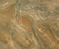
The central image in the above post has some of the best examples of direct imaging of (probable) cloud elevation differences that I have seen in images of Jupiter. Here is an enlarged crop from the image with some annotations:
The sun illuminates the clouds from the west (left) in this image. Keeping this in mind it's looking very much like we are seeing 'topography' at various locations, in particular around the vortex left of center: A: Clearly defined 'valleys'. B: More subtle 'valleys' than in A. C: Elevated and elongated high altitude 'walls' of clouds that are apparently roughly parallel to the wind direction around the vortex. D: Elevated clouds that have a more irregular shape than the clouds in C. There are also some some subtle indications that narrower and subtle 'valleys' and 'ridges' may spiral into the vortex toward its center. It is possible that these features are due to clouds of different color/brightness and not due to altitude differences. However, looking at the image, altitude differences look to me like the obvious (and more likely) explanation. |
|
|
|
|
|
 Gerald Juno perijove 8 Aug 21 2017, 09:13 PM
 PhilipTerryGraham Curious question: when they say that this is the ... Aug 24 2017, 02:19 AM nprev I didn't see anything about a last vote. I did... Aug 24 2017, 02:24 AM PhilipTerryGraham It's the main subtitle under the link to the P... Aug 24 2017, 10:14 AM Bjorn Jonsson This may have something to do with the fact that t... Aug 24 2017, 02:25 PM
 Candy Hansen QUOTE (Bjorn Jonsson @ Aug 24 2017, 07:25... Aug 24 2017, 05:13 PM tedstryk QUOTE (Candy Hansen @ Aug 24 2017, 06:13 ... Aug 25 2017, 12:55 AM mcaplinger QUOTE (tedstryk @ Aug 24 2017, 04:55 PM) ... Aug 25 2017, 02:46 PM mcaplinger QUOTE (Candy Hansen @ Aug 24 2017, 09:13 ... Aug 25 2017, 04:12 PM nprev QUOTE (mcaplinger @ Aug 25 2017, 08:12 AM... Aug 26 2017, 10:19 AM Gerald For the small team, there is currently a very high... Aug 25 2017, 12:28 PM Jackbauer first image :
https://www.missionjuno.swri.edu/ju... Sep 4 2017, 09:31 PM Gerald Perijove-08 RGB drafts, approach and close-ups. Th... Sep 5 2017, 06:46 AM Sean Here is a quick process of Gerald's first pass... Sep 5 2017, 10:05 AM climber Just beautiful !
Can't wait to watch wheth... Sep 5 2017, 12:31 PM tedstryk QUOTE (climber @ Sep 5 2017, 01:31 PM) Ju... Sep 7 2017, 08:47 PM Gerald Perijove 08, images #105, #107, and #108:
Those... Sep 5 2017, 01:41 PM Gerald #109
Sep 5 2017, 01:43 PM Gerald #110:
Sep 5 2017, 01:44 PM Gerald #111:
Sep 5 2017, 01:45 PM Gerald #112:
Sep 5 2017, 01:47 PM Gerald #113, with some remaining repetitive artifacts, I... Sep 5 2017, 01:49 PM JRehling What this helped me realize is that the programs I... Sep 6 2017, 03:50 PM Gerald #114, also preliminary due to residual repetitive ... Sep 5 2017, 01:56 PM Gerald #116:
Sep 5 2017, 01:58 PM Gerald #117:
Sep 5 2017, 01:59 PM Gerald #118:
Sep 5 2017, 02:00 PM Gerald #119:
Sep 5 2017, 02:01 PM Gerald #120:
Sep 5 2017, 02:03 PM Gerald #121, and #122:
Sep 5 2017, 02:05 PM Gerald #123, and #124:
Sep 5 2017, 02:07 PM Gerald And the last two for now, #125, and #126:
Sep 5 2017, 02:09 PM Sean Wow Gerald...just fantastic. I'm rolling up my... Sep 5 2017, 02:11 PM Johann Guillon Hi everybody,
here's my contribution for thi... Sep 5 2017, 08:14 PM stevesliva QUOTE (Johann Guillon @ Sep 5 2017, 04:14... Sep 6 2017, 03:25 AM Johann Guillon QUOTE (stevesliva @ Sep 6 2017, 04:25 AM)... Sep 6 2017, 04:33 PM mcaplinger BTW, note that image 114 ("Collision of colou... Sep 6 2017, 01:00 AM Gerald QUOTE (mcaplinger @ Sep 6 2017, 03:00 AM)... Sep 6 2017, 12:56 PM Bjorn Jonsson QUOTE (mcaplinger @ Sep 6 2017, 01:00 AM)... Sep 22 2017, 10:59 PM Gabriel Im astonished by your work gerald, here is a quic... Sep 6 2017, 02:58 AM Sean Here is a 19 frame PJ08 sequence based on Gerald... Sep 6 2017, 03:28 PM Sean Updated process with Gerald's source... PJ08_1... Sep 7 2017, 02:01 PM jasedm QUOTE (Sean @ Sep 7 2017, 03:01 PM) Updat... Sep 7 2017, 09:03 PM Sean Thankee.
Here is a portrait of PJ08_124 using Ge... Sep 7 2017, 09:15 PM JRehling I don't know when we got conclusive evidence t... Sep 8 2017, 12:00 AM Phil Stooke Great pictures everyone!
I can't be absol... Sep 8 2017, 04:19 PM Phil Stooke Here's an image to compare with the Juno view,... Sep 8 2017, 04:31 PM Sean Here is a detail from Gerald's PJ08_118...
... Sep 8 2017, 06:50 PM Sean Here is a portrait from Gerald's PJ08_108...
... Sep 9 2017, 07:46 PM Gerald 125-fold Perijove-08 animation on Youtube.
MP4 vid... Sep 12 2017, 05:30 AM Sean Thanks for sharing these Gerald, there is so much ... Sep 12 2017, 09:29 AM Sean I shared Gerald's PJ08 sequence over on Twitte... Sep 15 2017, 05:51 PM stevesliva QUOTE (Sean @ Sep 15 2017, 12:51 PM) I sh... Sep 18 2017, 01:57 PM MahFL QUOTE (Sean @ Sep 15 2017, 05:51 PM) I sh... Sep 23 2017, 01:32 AM Sean Here are some upscaled, processed & retimed cl... Sep 16 2017, 09:59 PM Sean It's hanging in Lund, Sweden. Sep 18 2017, 05:49 PM Bjorn Jonsson After making a few improvements to my Juno-related... Sep 18 2017, 10:42 PM Sean Beautiful work Bjorn.
Here is a montage of Gerald... Sep 20 2017, 10:07 AM Bjorn Jonsson And here are two more images processed from PJ8_11... Sep 22 2017, 11:16 PM Bjorn Jonsson Here is an image from the departure sequence:
T... Sep 23 2017, 10:17 PM scalbers Nice to see these realistically processed views. O... Sep 24 2017, 12:00 AM Bjorn Jonsson The limb is not fully shown. The images are proces... Oct 1 2017, 12:43 PM Bjorn Jonsson Image PJ8_110, approximately true color/contrast:
... Oct 6 2017, 07:51 PM Bjorn Jonsson Image PJ8_124, true color/contrast version and an ... Oct 16 2017, 09:52 PM Gerald John Rogers (BAA) posted his detailed and interest... Oct 18 2017, 06:20 PM elakdawalla Jupiter's south pole is a "vortex crystal... Oct 19 2017, 03:15 AM Gerald I doubt, that these things are cleared for public ... Oct 19 2017, 09:43 AM mcaplinger QUOTE (Gerald @ Oct 19 2017, 01:43 AM) I ... Oct 19 2017, 02:44 PM Gerald After some more investigation, I think, that we ar... Oct 19 2017, 03:57 PM mcaplinger QUOTE (Gerald @ Oct 19 2017, 07:57 AM) Af... Oct 19 2017, 04:04 PM Gerald You are in Candy's team. Without your camera n... Oct 19 2017, 04:16 PM Bjorn Jonsson Yet another collection of images, this is from PJ8... Oct 23 2017, 11:18 PM Brian Swift My PJ08 approach movie. PJ08 Approach Movie Has a... Nov 5 2017, 09:15 PM Sean PJ08_108 update [G.Eichstadt]
Detail Dec 18 2017, 05:15 AM Sean Update to PJ08_123 [G.Eichstadt]
I've arrive... Dec 27 2017, 04:43 PM Sean PJ08 latter sequence Mar 8 2018, 02:27 AM Sean PJ08_122_new pass Apr 13 2018, 04:47 PM Sean PJ08_121 new process pass details & portrait Apr 16 2018, 12:02 AM JRehling Check out the little red spot in the upper left of... Apr 16 2018, 04:02 AM
Candy Hansen QUOTE (Bjorn Jonsson @ Aug 24 2017, 07:25... Aug 24 2017, 05:13 PM tedstryk QUOTE (Candy Hansen @ Aug 24 2017, 06:13 ... Aug 25 2017, 12:55 AM mcaplinger QUOTE (tedstryk @ Aug 24 2017, 04:55 PM) ... Aug 25 2017, 02:46 PM mcaplinger QUOTE (Candy Hansen @ Aug 24 2017, 09:13 ... Aug 25 2017, 04:12 PM nprev QUOTE (mcaplinger @ Aug 25 2017, 08:12 AM... Aug 26 2017, 10:19 AM Gerald For the small team, there is currently a very high... Aug 25 2017, 12:28 PM Jackbauer first image :
https://www.missionjuno.swri.edu/ju... Sep 4 2017, 09:31 PM Gerald Perijove-08 RGB drafts, approach and close-ups. Th... Sep 5 2017, 06:46 AM Sean Here is a quick process of Gerald's first pass... Sep 5 2017, 10:05 AM climber Just beautiful !
Can't wait to watch wheth... Sep 5 2017, 12:31 PM tedstryk QUOTE (climber @ Sep 5 2017, 01:31 PM) Ju... Sep 7 2017, 08:47 PM Gerald Perijove 08, images #105, #107, and #108:
Those... Sep 5 2017, 01:41 PM Gerald #109
Sep 5 2017, 01:43 PM Gerald #110:
Sep 5 2017, 01:44 PM Gerald #111:
Sep 5 2017, 01:45 PM Gerald #112:
Sep 5 2017, 01:47 PM Gerald #113, with some remaining repetitive artifacts, I... Sep 5 2017, 01:49 PM JRehling What this helped me realize is that the programs I... Sep 6 2017, 03:50 PM Gerald #114, also preliminary due to residual repetitive ... Sep 5 2017, 01:56 PM Gerald #116:
Sep 5 2017, 01:58 PM Gerald #117:
Sep 5 2017, 01:59 PM Gerald #118:
Sep 5 2017, 02:00 PM Gerald #119:
Sep 5 2017, 02:01 PM Gerald #120:
Sep 5 2017, 02:03 PM Gerald #121, and #122:
Sep 5 2017, 02:05 PM Gerald #123, and #124:
Sep 5 2017, 02:07 PM Gerald And the last two for now, #125, and #126:
Sep 5 2017, 02:09 PM Sean Wow Gerald...just fantastic. I'm rolling up my... Sep 5 2017, 02:11 PM Johann Guillon Hi everybody,
here's my contribution for thi... Sep 5 2017, 08:14 PM stevesliva QUOTE (Johann Guillon @ Sep 5 2017, 04:14... Sep 6 2017, 03:25 AM Johann Guillon QUOTE (stevesliva @ Sep 6 2017, 04:25 AM)... Sep 6 2017, 04:33 PM mcaplinger BTW, note that image 114 ("Collision of colou... Sep 6 2017, 01:00 AM Gerald QUOTE (mcaplinger @ Sep 6 2017, 03:00 AM)... Sep 6 2017, 12:56 PM Bjorn Jonsson QUOTE (mcaplinger @ Sep 6 2017, 01:00 AM)... Sep 22 2017, 10:59 PM Gabriel Im astonished by your work gerald, here is a quic... Sep 6 2017, 02:58 AM Sean Here is a 19 frame PJ08 sequence based on Gerald... Sep 6 2017, 03:28 PM Sean Updated process with Gerald's source... PJ08_1... Sep 7 2017, 02:01 PM jasedm QUOTE (Sean @ Sep 7 2017, 03:01 PM) Updat... Sep 7 2017, 09:03 PM Sean Thankee.
Here is a portrait of PJ08_124 using Ge... Sep 7 2017, 09:15 PM JRehling I don't know when we got conclusive evidence t... Sep 8 2017, 12:00 AM Phil Stooke Great pictures everyone!
I can't be absol... Sep 8 2017, 04:19 PM Phil Stooke Here's an image to compare with the Juno view,... Sep 8 2017, 04:31 PM Sean Here is a detail from Gerald's PJ08_118...
... Sep 8 2017, 06:50 PM Sean Here is a portrait from Gerald's PJ08_108...
... Sep 9 2017, 07:46 PM Gerald 125-fold Perijove-08 animation on Youtube.
MP4 vid... Sep 12 2017, 05:30 AM Sean Thanks for sharing these Gerald, there is so much ... Sep 12 2017, 09:29 AM Sean I shared Gerald's PJ08 sequence over on Twitte... Sep 15 2017, 05:51 PM stevesliva QUOTE (Sean @ Sep 15 2017, 12:51 PM) I sh... Sep 18 2017, 01:57 PM MahFL QUOTE (Sean @ Sep 15 2017, 05:51 PM) I sh... Sep 23 2017, 01:32 AM Sean Here are some upscaled, processed & retimed cl... Sep 16 2017, 09:59 PM Sean It's hanging in Lund, Sweden. Sep 18 2017, 05:49 PM Bjorn Jonsson After making a few improvements to my Juno-related... Sep 18 2017, 10:42 PM Sean Beautiful work Bjorn.
Here is a montage of Gerald... Sep 20 2017, 10:07 AM Bjorn Jonsson And here are two more images processed from PJ8_11... Sep 22 2017, 11:16 PM Bjorn Jonsson Here is an image from the departure sequence:
T... Sep 23 2017, 10:17 PM scalbers Nice to see these realistically processed views. O... Sep 24 2017, 12:00 AM Bjorn Jonsson The limb is not fully shown. The images are proces... Oct 1 2017, 12:43 PM Bjorn Jonsson Image PJ8_110, approximately true color/contrast:
... Oct 6 2017, 07:51 PM Bjorn Jonsson Image PJ8_124, true color/contrast version and an ... Oct 16 2017, 09:52 PM Gerald John Rogers (BAA) posted his detailed and interest... Oct 18 2017, 06:20 PM elakdawalla Jupiter's south pole is a "vortex crystal... Oct 19 2017, 03:15 AM Gerald I doubt, that these things are cleared for public ... Oct 19 2017, 09:43 AM mcaplinger QUOTE (Gerald @ Oct 19 2017, 01:43 AM) I ... Oct 19 2017, 02:44 PM Gerald After some more investigation, I think, that we ar... Oct 19 2017, 03:57 PM mcaplinger QUOTE (Gerald @ Oct 19 2017, 07:57 AM) Af... Oct 19 2017, 04:04 PM Gerald You are in Candy's team. Without your camera n... Oct 19 2017, 04:16 PM Bjorn Jonsson Yet another collection of images, this is from PJ8... Oct 23 2017, 11:18 PM Brian Swift My PJ08 approach movie. PJ08 Approach Movie Has a... Nov 5 2017, 09:15 PM Sean PJ08_108 update [G.Eichstadt]
Detail Dec 18 2017, 05:15 AM Sean Update to PJ08_123 [G.Eichstadt]
I've arrive... Dec 27 2017, 04:43 PM Sean PJ08 latter sequence Mar 8 2018, 02:27 AM Sean PJ08_122_new pass Apr 13 2018, 04:47 PM Sean PJ08_121 new process pass details & portrait Apr 16 2018, 12:02 AM JRehling Check out the little red spot in the upper left of... Apr 16 2018, 04:02 AM |

|
Lo-Fi Version | Time is now: 22nd September 2024 - 11:41 PM |
|
RULES AND GUIDELINES Please read the Forum Rules and Guidelines before posting. IMAGE COPYRIGHT |
OPINIONS AND MODERATION Opinions expressed on UnmannedSpaceflight.com are those of the individual posters and do not necessarily reflect the opinions of UnmannedSpaceflight.com or The Planetary Society. The all-volunteer UnmannedSpaceflight.com moderation team is wholly independent of The Planetary Society. The Planetary Society has no influence over decisions made by the UnmannedSpaceflight.com moderators. |
SUPPORT THE FORUM Unmannedspaceflight.com is funded by the Planetary Society. Please consider supporting our work and many other projects by donating to the Society or becoming a member. |
|