MSL Route Map |

MSL Route Map |
 Aug 29 2012, 08:52 PM Aug 29 2012, 08:52 PM
Post
#1
|
|||
|
Solar System Cartographer  Group: Members Posts: 10226 Joined: 5-April 05 From: Canada Member No.: 227 |
Thread created for posting MSL route maps and map updates.
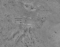
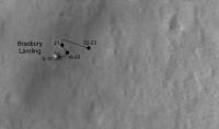
Comments / suggestions adding value to the route maps are allowed, but discussions regarding the route itself and "future" paths are not. Use the currently active thread for the latter. Eduardo Tesheiner Moderator ----- Here's an updated map of activities near the landing site and the start of a map of the route to Glenelg. I may get one more step added to this before I have to take a break Aug. 31 to Sept 16, and I will resume it after that. Details will be revised as necessary as we go. Phil
-------------------- ... because the Solar System ain't gonna map itself.
Also to be found posting similar content on https://mastodon.social/@PhilStooke Maps for download (free PDF: https://upload.wikimedia.org/wikipedia/comm...Cartography.pdf NOTE: everything created by me which I post on UMSF is considered to be in the public domain (NOT CC, public domain) |
||
 |
 
|
||
 |
|
Dec 9 2017, 07:34 PM
Post
#2
|
||
 Member Group: Members Posts: 966 Joined: 15-June 09 From: Lisbon, Portugal Member No.: 4824 |
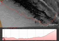
Curiosity continues to climb Mt. Sharp. It is now more than 330m (~1100 ft) above Yellowknife Bay, the lowest point in its route (thanks Paolo!). This is only a rough sketch, the elevation profile's alignment with the route is poor, but I hope it conveys the idea.
Fernando
|
|
|
|
|
|
|
Dec 13 2017, 06:52 PM
Post
#3
|
||
 Senior Member Group: Members Posts: 1089 Joined: 19-February 05 From: Close to Meudon Observatory in France Member No.: 172 |
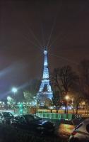
QUOTE (nogal @ Dec 9 2017, 08:34 PM)  Curiosity continues to climb Mt. Sharp. It is now more than 330m (~1100 ft) above Yellowknife Bay, the lowest point in its route (thanks Paolo!). This is only a rough sketch, the elevation profile's alignment with the route is poor, but I hope it conveys the idea. Fernando Wow ! Thanks Nogal : a 330m climb goes definitely above the summit (antenna) of the Eiffel Tower (325 m).
An image I took last Sunday... Enjoy 
|
|
|
|
|
|
|
Dec 13 2017, 09:52 PM
Post
#4
|
|
|
Member Group: Members Posts: 966 Joined: 15-June 09 From: Lisbon, Portugal Member No.: 4824 |
Thanks vikingmars. The height difference in the PDS data set (sols 0 to 1781) is approximately 294m, but Curiosity has continued her climb ever since.
Ah, Paris! When I was young I once climbed the Eiffel Tower till the second floor, the access was free. Many steps, a hard climb, but was rewarded with a magnificent view. Lovely photo, thank you. |
|
|
|
 Phil Stooke MSL Route Map Aug 29 2012, 08:52 PM
 nogal Update to sol 1891.
Fernando
Dec 4 2017, 01:05 AM
nogal Update to sol 1891.
Fernando
Dec 4 2017, 01:05 AM
 PaulH51 QUOTE (nogal @ Dec 4 2017, 09:05 AM) Upda... Dec 4 2017, 01:56 AM nogal Thanks Paul. Curiosity drove about 19.2m on sol 1... Dec 4 2017, 05:04 PM Phil Stooke Map update to sol 1894. I will do an overview soo... Dec 5 2017, 12:25 AM Phil Stooke Damia's latest panorama shows us inside the da... Dec 6 2017, 06:25 PM nogal This update to sol 1899 includes the data from the... Dec 9 2017, 04:39 PM Phil Stooke We had a drive of 25-30 m roughly, to the south an... Dec 11 2017, 07:56 PM Phil Stooke ... and a wider context map.
Phil
Dec 11 2017, 08:44 PM Phil Stooke A short jog to the west on sol 1903.
Phil
Dec 13 2017, 05:12 PM Phil Stooke I took the elevator up the tower! Back in the... Dec 16 2017, 07:43 AM nogal I was on my high-school-finalist's trip and my... Dec 16 2017, 06:39 PM Phil Stooke Update to sol 1910, with a return to the bright ou... Dec 21 2017, 12:37 AM serpens Obviously an outcrop of more than passing interest... Dec 21 2017, 02:02 AM nogal Just as things were getting really interesting (La... Dec 21 2017, 02:00 PM Bobby Richardson QUOTE (nogal @ Dec 21 2017, 09:00 AM) ... Dec 22 2017, 01:56 AM Phil Stooke Map update to sol 1912, a short move back to almos... Dec 23 2017, 07:22 AM Phil Stooke This is a preliminary version of a close-up map of... Jan 3 2018, 06:38 PM nogal Happy New Year!
Here is another way to look a... Jan 5 2018, 02:59 PM Phil Stooke Here's my map for sol 1928 - we already moved ... Jan 9 2018, 08:09 PM Phil Stooke This time the exact location is not very reliable ... Jan 10 2018, 08:55 PM SkyeLab Hi Phil, one of your splendid maps has made it to ... Jan 11 2018, 12:33 PM nogal Update to sol 1933. Curiosity has passed the 18km... Jan 13 2018, 01:28 PM nogal Update to sol 1939. A bump of 5m to position Curi... Jan 19 2018, 06:33 PM Phil Stooke My update to sol 1939, using Paul's panorama f... Jan 19 2018, 07:01 PM Phil Stooke On sol 1942, Curiosity sailed the ocean blue... a ... Jan 22 2018, 05:30 PM Phil Stooke Sol 1944, driving south and west a bit to look at ... Jan 25 2018, 12:31 AM Phil Stooke Still on sol 1944, but an overview of the area sho... Jan 25 2018, 10:57 PM nogal Update to sol 1946. A long drive of about 45m with... Jan 27 2018, 03:12 PM Phil Stooke Thanks, Nogal. Your .kmz files are really useful.... Jan 27 2018, 07:03 PM nogal Thank you Phil. I do appreciate it. You know that ... Jan 27 2018, 11:31 PM Sean Small bump for my VR ready 3D map of the area Fern... Jan 28 2018, 12:16 AM nogal Oh Sean this is priceless! Thank you.
Woul... Jan 28 2018, 12:27 AM Sean I could update with a new texture that uses Phil... Jan 28 2018, 04:28 PM nogal Hi Sean,
Only later did I found out there already ... Jan 28 2018, 04:58 PM Sean I'm not sure if that would be any easier than ... Jan 29 2018, 01:59 AM Phil Stooke Update to sol 1949, and another drive is scheduled... Jan 30 2018, 06:25 PM nogal QUOTE (Phil Stooke @ Jan 30 2018, 06:25 P... Jan 30 2018, 11:01 PM Phil Stooke Update to include the sol 1950 drive.
Phil
Jan 31 2018, 09:49 PM Phil Stooke I have been posting these maps since landing (and ... Feb 1 2018, 11:54 PM nogal Update to sol 1952 (last drive on sol 1950), inclu... Feb 3 2018, 02:18 PM Phil Stooke Sol 1962, a drive to a bright outcrop sitting in a... Feb 12 2018, 07:42 PM nogal It seems Curiosity might stay at sol's 1963 lo... Feb 13 2018, 04:59 PM Phil Stooke A drive on sol 1985... here's an updated map. ... Mar 8 2018, 03:15 AM Phil Stooke A roughly 50 m drive on sol 1986. That is shorter... Mar 9 2018, 06:29 PM Phil Stooke I was right about the last drive - it was much lon... Mar 12 2018, 01:59 AM nogal QUOTE (Phil Stooke @ Mar 12 2018, 01:59 A... Mar 12 2018, 04:30 PM Phil Stooke 15 m on sol 1991 - quick update. I will be travel... Mar 14 2018, 05:28 PM ngunn Thanks as always for the great mapping work. Just... Mar 14 2018, 08:57 PM Phil Stooke Niggles are always welcome! I took the name f... Mar 14 2018, 09:22 PM nogal Update to sol 1993, a drive of about 34m in the NE... Mar 16 2018, 07:28 PM Phil Stooke Thanks, Fernando! I am in my hotel in Houston... Mar 17 2018, 02:44 AM Phil Stooke A drive on sol 1996 took us out of my map area, so... Mar 20 2018, 03:14 AM Phil Stooke A short drive on sol 1998.
Phil
Mar 22 2018, 02:22 AM Phil Stooke ... and a slightly longer one (15 m) on sol 1999.
... Mar 22 2018, 02:47 PM nogal Update to sol 1999 (sol 2002). The next drive is... Mar 25 2018, 06:12 PM Phil Stooke The 2003 drive faulted out but 2004 recovered it. ... Mar 27 2018, 04:52 PM fredk QUOTE (Phil Stooke @ Mar 27 2018, 05:52 P... Mar 27 2018, 06:39 PM nogal Hi Phil,
The path is a bit more to the west and ha... Mar 27 2018, 04:58 PM nogal Phil you're the greatest! The data on whi... Mar 29 2018, 01:34 PM Phil Stooke I was all set to change my map... good job I didn... Mar 29 2018, 03:00 PM nogal Update to sol 2006 (last move on sol 2004) and cel... Mar 30 2018, 02:45 PM Phil Stooke 3 Mars years! And another drive on sol 2007 -... Mar 30 2018, 03:09 PM Phil Stooke We moved east on sol 2009, up to a small scarp whi... Apr 2 2018, 03:00 PM Sean Thought you might like to see some in-progress col... Apr 2 2018, 06:41 PM Phil Stooke No, I can assure you nobody wants to see that.
Ph... Apr 2 2018, 07:39 PM Sean *edit* Apr 3 2018, 08:34 AM Explorer1 Sarcasm doesn't come through easily by text. G... Apr 3 2018, 12:41 PM Phil Stooke It would be amazing to zoom in on the full size ve... Apr 4 2018, 03:43 PM nogal Update to sol 2014. Curiosity moved SSE and to h... Apr 6 2018, 05:50 PM Phil Stooke Roughly here... may need to edit later.
Phil
Apr 6 2018, 10:10 PM Phil Stooke Here is a closer look at recent activities on Vera... Apr 8 2018, 09:14 PM Phil Stooke A short drive on sol 2017 to look at the other sid... Apr 9 2018, 06:13 PM Phil Stooke A short drive on sol 2020 to reach a rock beside t... Apr 13 2018, 02:05 AM Phil Stooke We moved down the slope to stop on the dark drifts... Apr 16 2018, 01:29 AM nogal Update to sol 2023.
Fernando
Apr 17 2018, 04:44 PM Phil Stooke A hefty drive on sol 2027. This is just taken fro... Apr 20 2018, 06:38 PM nogal Update to sol 2027. A WNW drive of about 88m and 1... Apr 21 2018, 01:44 PM Phil Stooke On sol 2030 we moved 12 or 15 m west (and a bit so... Apr 23 2018, 04:37 AM Phil Stooke Another drive on sol 2032. A larger scale map wi... Apr 25 2018, 06:13 PM Phil Stooke I just have an approximate position and drive path... Apr 27 2018, 05:31 PM Sean Here is Gale & MSL Route map with added notion... Apr 27 2018, 11:49 PM PaulH51 QUOTE (Sean @ Apr 28 2018, 07:49 AM) Here... Apr 28 2018, 01:54 AM nogal QUOTE (Sean @ Apr 28 2018, 12:49 AM) Here... Apr 28 2018, 09:28 PM Phil Stooke Amazing. Thanks so much for all your work on this... Apr 28 2018, 12:09 AM nogal Update to sol 2034.
Fernando
Apr 28 2018, 10:08 PM Phil Stooke I don't have a good position yet for sol 2036,... Apr 30 2018, 04:23 AM Phil Stooke We moved over 40 m southwest on sol 2039, towards ... May 2 2018, 06:52 PM Phil Stooke Another c. 40 m drive on sol 2040. Unfortunately, ... May 3 2018, 08:03 PM nogal Update to sol 2041. Less than 20m to the 19km mar... May 4 2018, 08:28 PM Phil Stooke Thanks, Fernando! Here's my map for sol 2... May 5 2018, 02:07 AM nogal My pleasure, Phil! But I did miss the new nam... May 5 2018, 04:19 PM Phil Stooke Sol 2044, move to a nice big chunk of rock.
Phil
... May 7 2018, 04:57 PM Phil Stooke OK, off the big chunk of rock and down onto the lo... May 9 2018, 05:41 PM Phil Stooke Quite a few edits since the last map, mostly to al... May 11 2018, 10:42 PM nogal Update to sol 2047, with Phil's names and the ... May 13 2018, 01:57 PM Phil Stooke Sol 2052: a c. 10 m drive to the northwest, perilo... May 15 2018, 07:48 PM Phil Stooke Sol 2053, a drive around the rock target Duluth. ... May 16 2018, 09:45 PM
PaulH51 QUOTE (nogal @ Dec 4 2017, 09:05 AM) Upda... Dec 4 2017, 01:56 AM nogal Thanks Paul. Curiosity drove about 19.2m on sol 1... Dec 4 2017, 05:04 PM Phil Stooke Map update to sol 1894. I will do an overview soo... Dec 5 2017, 12:25 AM Phil Stooke Damia's latest panorama shows us inside the da... Dec 6 2017, 06:25 PM nogal This update to sol 1899 includes the data from the... Dec 9 2017, 04:39 PM Phil Stooke We had a drive of 25-30 m roughly, to the south an... Dec 11 2017, 07:56 PM Phil Stooke ... and a wider context map.
Phil
Dec 11 2017, 08:44 PM Phil Stooke A short jog to the west on sol 1903.
Phil
Dec 13 2017, 05:12 PM Phil Stooke I took the elevator up the tower! Back in the... Dec 16 2017, 07:43 AM nogal I was on my high-school-finalist's trip and my... Dec 16 2017, 06:39 PM Phil Stooke Update to sol 1910, with a return to the bright ou... Dec 21 2017, 12:37 AM serpens Obviously an outcrop of more than passing interest... Dec 21 2017, 02:02 AM nogal Just as things were getting really interesting (La... Dec 21 2017, 02:00 PM Bobby Richardson QUOTE (nogal @ Dec 21 2017, 09:00 AM) ... Dec 22 2017, 01:56 AM Phil Stooke Map update to sol 1912, a short move back to almos... Dec 23 2017, 07:22 AM Phil Stooke This is a preliminary version of a close-up map of... Jan 3 2018, 06:38 PM nogal Happy New Year!
Here is another way to look a... Jan 5 2018, 02:59 PM Phil Stooke Here's my map for sol 1928 - we already moved ... Jan 9 2018, 08:09 PM Phil Stooke This time the exact location is not very reliable ... Jan 10 2018, 08:55 PM SkyeLab Hi Phil, one of your splendid maps has made it to ... Jan 11 2018, 12:33 PM nogal Update to sol 1933. Curiosity has passed the 18km... Jan 13 2018, 01:28 PM nogal Update to sol 1939. A bump of 5m to position Curi... Jan 19 2018, 06:33 PM Phil Stooke My update to sol 1939, using Paul's panorama f... Jan 19 2018, 07:01 PM Phil Stooke On sol 1942, Curiosity sailed the ocean blue... a ... Jan 22 2018, 05:30 PM Phil Stooke Sol 1944, driving south and west a bit to look at ... Jan 25 2018, 12:31 AM Phil Stooke Still on sol 1944, but an overview of the area sho... Jan 25 2018, 10:57 PM nogal Update to sol 1946. A long drive of about 45m with... Jan 27 2018, 03:12 PM Phil Stooke Thanks, Nogal. Your .kmz files are really useful.... Jan 27 2018, 07:03 PM nogal Thank you Phil. I do appreciate it. You know that ... Jan 27 2018, 11:31 PM Sean Small bump for my VR ready 3D map of the area Fern... Jan 28 2018, 12:16 AM nogal Oh Sean this is priceless! Thank you.
Woul... Jan 28 2018, 12:27 AM Sean I could update with a new texture that uses Phil... Jan 28 2018, 04:28 PM nogal Hi Sean,
Only later did I found out there already ... Jan 28 2018, 04:58 PM Sean I'm not sure if that would be any easier than ... Jan 29 2018, 01:59 AM Phil Stooke Update to sol 1949, and another drive is scheduled... Jan 30 2018, 06:25 PM nogal QUOTE (Phil Stooke @ Jan 30 2018, 06:25 P... Jan 30 2018, 11:01 PM Phil Stooke Update to include the sol 1950 drive.
Phil
Jan 31 2018, 09:49 PM Phil Stooke I have been posting these maps since landing (and ... Feb 1 2018, 11:54 PM nogal Update to sol 1952 (last drive on sol 1950), inclu... Feb 3 2018, 02:18 PM Phil Stooke Sol 1962, a drive to a bright outcrop sitting in a... Feb 12 2018, 07:42 PM nogal It seems Curiosity might stay at sol's 1963 lo... Feb 13 2018, 04:59 PM Phil Stooke A drive on sol 1985... here's an updated map. ... Mar 8 2018, 03:15 AM Phil Stooke A roughly 50 m drive on sol 1986. That is shorter... Mar 9 2018, 06:29 PM Phil Stooke I was right about the last drive - it was much lon... Mar 12 2018, 01:59 AM nogal QUOTE (Phil Stooke @ Mar 12 2018, 01:59 A... Mar 12 2018, 04:30 PM Phil Stooke 15 m on sol 1991 - quick update. I will be travel... Mar 14 2018, 05:28 PM ngunn Thanks as always for the great mapping work. Just... Mar 14 2018, 08:57 PM Phil Stooke Niggles are always welcome! I took the name f... Mar 14 2018, 09:22 PM nogal Update to sol 1993, a drive of about 34m in the NE... Mar 16 2018, 07:28 PM Phil Stooke Thanks, Fernando! I am in my hotel in Houston... Mar 17 2018, 02:44 AM Phil Stooke A drive on sol 1996 took us out of my map area, so... Mar 20 2018, 03:14 AM Phil Stooke A short drive on sol 1998.
Phil
Mar 22 2018, 02:22 AM Phil Stooke ... and a slightly longer one (15 m) on sol 1999.
... Mar 22 2018, 02:47 PM nogal Update to sol 1999 (sol 2002). The next drive is... Mar 25 2018, 06:12 PM Phil Stooke The 2003 drive faulted out but 2004 recovered it. ... Mar 27 2018, 04:52 PM fredk QUOTE (Phil Stooke @ Mar 27 2018, 05:52 P... Mar 27 2018, 06:39 PM nogal Hi Phil,
The path is a bit more to the west and ha... Mar 27 2018, 04:58 PM nogal Phil you're the greatest! The data on whi... Mar 29 2018, 01:34 PM Phil Stooke I was all set to change my map... good job I didn... Mar 29 2018, 03:00 PM nogal Update to sol 2006 (last move on sol 2004) and cel... Mar 30 2018, 02:45 PM Phil Stooke 3 Mars years! And another drive on sol 2007 -... Mar 30 2018, 03:09 PM Phil Stooke We moved east on sol 2009, up to a small scarp whi... Apr 2 2018, 03:00 PM Sean Thought you might like to see some in-progress col... Apr 2 2018, 06:41 PM Phil Stooke No, I can assure you nobody wants to see that.
Ph... Apr 2 2018, 07:39 PM Sean *edit* Apr 3 2018, 08:34 AM Explorer1 Sarcasm doesn't come through easily by text. G... Apr 3 2018, 12:41 PM Phil Stooke It would be amazing to zoom in on the full size ve... Apr 4 2018, 03:43 PM nogal Update to sol 2014. Curiosity moved SSE and to h... Apr 6 2018, 05:50 PM Phil Stooke Roughly here... may need to edit later.
Phil
Apr 6 2018, 10:10 PM Phil Stooke Here is a closer look at recent activities on Vera... Apr 8 2018, 09:14 PM Phil Stooke A short drive on sol 2017 to look at the other sid... Apr 9 2018, 06:13 PM Phil Stooke A short drive on sol 2020 to reach a rock beside t... Apr 13 2018, 02:05 AM Phil Stooke We moved down the slope to stop on the dark drifts... Apr 16 2018, 01:29 AM nogal Update to sol 2023.
Fernando
Apr 17 2018, 04:44 PM Phil Stooke A hefty drive on sol 2027. This is just taken fro... Apr 20 2018, 06:38 PM nogal Update to sol 2027. A WNW drive of about 88m and 1... Apr 21 2018, 01:44 PM Phil Stooke On sol 2030 we moved 12 or 15 m west (and a bit so... Apr 23 2018, 04:37 AM Phil Stooke Another drive on sol 2032. A larger scale map wi... Apr 25 2018, 06:13 PM Phil Stooke I just have an approximate position and drive path... Apr 27 2018, 05:31 PM Sean Here is Gale & MSL Route map with added notion... Apr 27 2018, 11:49 PM PaulH51 QUOTE (Sean @ Apr 28 2018, 07:49 AM) Here... Apr 28 2018, 01:54 AM nogal QUOTE (Sean @ Apr 28 2018, 12:49 AM) Here... Apr 28 2018, 09:28 PM Phil Stooke Amazing. Thanks so much for all your work on this... Apr 28 2018, 12:09 AM nogal Update to sol 2034.
Fernando
Apr 28 2018, 10:08 PM Phil Stooke I don't have a good position yet for sol 2036,... Apr 30 2018, 04:23 AM Phil Stooke We moved over 40 m southwest on sol 2039, towards ... May 2 2018, 06:52 PM Phil Stooke Another c. 40 m drive on sol 2040. Unfortunately, ... May 3 2018, 08:03 PM nogal Update to sol 2041. Less than 20m to the 19km mar... May 4 2018, 08:28 PM Phil Stooke Thanks, Fernando! Here's my map for sol 2... May 5 2018, 02:07 AM nogal My pleasure, Phil! But I did miss the new nam... May 5 2018, 04:19 PM Phil Stooke Sol 2044, move to a nice big chunk of rock.
Phil
... May 7 2018, 04:57 PM Phil Stooke OK, off the big chunk of rock and down onto the lo... May 9 2018, 05:41 PM Phil Stooke Quite a few edits since the last map, mostly to al... May 11 2018, 10:42 PM nogal Update to sol 2047, with Phil's names and the ... May 13 2018, 01:57 PM Phil Stooke Sol 2052: a c. 10 m drive to the northwest, perilo... May 15 2018, 07:48 PM Phil Stooke Sol 2053, a drive around the rock target Duluth. ... May 16 2018, 09:45 PM |

|
Lo-Fi Version | Time is now: 22nd September 2024 - 11:51 AM |
|
RULES AND GUIDELINES Please read the Forum Rules and Guidelines before posting. IMAGE COPYRIGHT |
OPINIONS AND MODERATION Opinions expressed on UnmannedSpaceflight.com are those of the individual posters and do not necessarily reflect the opinions of UnmannedSpaceflight.com or The Planetary Society. The all-volunteer UnmannedSpaceflight.com moderation team is wholly independent of The Planetary Society. The Planetary Society has no influence over decisions made by the UnmannedSpaceflight.com moderators. |
SUPPORT THE FORUM Unmannedspaceflight.com is funded by the Planetary Society. Please consider supporting our work and many other projects by donating to the Society or becoming a member. |
|