"Dragonfly" Titan explorer drone, NASA funds Johns Hopkins University Applied Physics Laboratory (APL) |

"Dragonfly" Titan explorer drone, NASA funds Johns Hopkins University Applied Physics Laboratory (APL) |
 Dec 20 2017, 09:04 PM Dec 20 2017, 09:04 PM
Post
#1
|
||
 Junior Member  Group: Members Posts: 66 Joined: 3-August 12 Member No.: 6454 |
Is there a specific website for this Johns Hopkins University Applied Physics Laboratory (APL) concept for a Titan explorer drone?
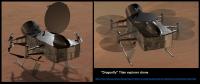
Looks to be an RTG powered machine, somewhat reminiscent of MSL Curiosity (RTG sticking out the tail end). But no camera mast, ChemCam, or sampling arm visible in the concept illustration. QUOTE Dec. 20, 2017 RELEASE 17-101 NASA Invests in Concept Development for Missions to Comet, Saturn Moon Titan Dragonfly Dragonfly is a drone-like rotorcraft that would explore the prebiotic chemistry and habitability of dozens of sites on Saturns moon Titan, an ocean world in our solar system. Elizabeth Turtle from the Johns Hopkins University Applied Physics Laboratory (APL) in Laurel, Maryland, is the lead investigator, with APL providing project management. https://www.nasa.gov/press-release/nasa-inv...turn-moon-titan
|
|
 |
 
|
|
 |
|
Dec 31 2017, 09:31 AM
Post
#2
|
|
|
Merciless Robot Group: Admin Posts: 8785 Joined: 8-December 05 From: Los Angeles Member No.: 602 |
I wonder how effectively it could navigate over long distances. We don't have nearly good enough surface maps for AI terrain recognition, there's no significant magnetic field, so all that's left is inertial. Maintaining a good heading alignment over long periods may be problematic since IMUs do have inherent drift, and though periodic realignment is the usual method to correct that Titan's outer shell rotation seems to vary significantly in comparison to the rest of the moon's mass (not sure if that's a fixed offset or variable), and measuring rate & direction of rotation after vertical alignment is the usual method of finding true north (and latitude).
This could possibly be augmented by RDFing the vehicle's downlink to Earth, but not sure how much position precision could be achieved...tens/hundreds of km? Then again, maybe the position of the Sun could be used as well, foggy though it's gonna be. Dunno if Saturn would be detectable, but the Sun's definitely gonna be the only possible reference star. -------------------- A few will take this knowledge and use this power of a dream realized as a force for change, an impetus for further discovery to make less ancient dreams real.
|
|
|
|
|
Dec 31 2017, 04:46 PM
Post
#3
|
|
|
Member Group: Members Posts: 715 Joined: 22-April 05 Member No.: 351 |
QUOTE (nprev @ Dec 31 2017, 01:31 AM)  I wonder how effectively it could navigate over long distances. We don't have nearly good enough surface maps for AI terrain recognition, there's no significant magnetic field, so all that's left is inertial. Maintaining a good heading alignment over long periods may be problematic since IMUs do have inherent drift, and though periodic realignment is the usual method to correct that Titan's outer shell rotation seems to vary significantly in comparison to the rest of the moon's mass (not sure if that's a fixed offset or variable), and measuring rate & direction of rotation after vertical alignment is the usual method of finding true north (and latitude). This could possibly be augmented by RDFing the vehicle's downlink to Earth, but not sure how much position precision could be achieved...tens/hundreds of km? Then again, maybe the position of the Sun could be used as well, foggy though it's gonna be. Dunno if Saturn would be detectable, but the Sun's definitely gonna be the only possible reference star. From Ralph et al.'s paper, Dragonfly would do 40 km hops with 16 days between. I presume the quadcopter would have its position updated during the between days. The paper hints that longer flights are likely possible and 40 km is the safe planning distance. One factor that would shorten traverses is the plan to use each flight to locate a more distant future landing site and then fly back to a previously scouted nearer landing site. With experience, the mission team might gain the confidence to not do the fly back and allow the quadcopter to chose its own safe landing site. With lidar or structure from motion (building 3D maps from stereo images), Dragonfly could continuously search for safe landing sites below its flight path and know of safe landing sites. -------------------- |
|
|
|
|
Dec 31 2017, 10:17 PM
Post
#4
|
|
|
Merciless Robot Group: Admin Posts: 8785 Joined: 8-December 05 From: Los Angeles Member No.: 602 |
QUOTE (vjkane @ Dec 31 2017, 08:46 AM) With experience, the mission team might gain the confidence to not do the fly back and allow the quadcopter to chose its own safe landing site. With lidar or structure from motion (building 3D maps from stereo images), Dragonfly could continuously search for safe landing sites below its flight path and know of safe landing sites. Interesting, and thanks for the responses, all. Didn't know that terrestrial-based radiometry was accurate at sub-km resolution, Mike, so that solves the main problem: navigating to targets like lakes and cryovolcano candidates that may be extremely distant from the original landing site. Periodic position fixes combined with the local-scale 'hop & look' nav methods described should solve that with a high degree of precision and operational safety. -------------------- A few will take this knowledge and use this power of a dream realized as a force for change, an impetus for further discovery to make less ancient dreams real.
|
|
|
|
 Jaro_in_Montreal "Dragonfly" Titan explorer drone Dec 20 2017, 09:04 PM
 elakdawalla dragonfly.jhuapl.edu Dec 20 2017, 09:33 PM
 rlorenz QUOTE (elakdawalla @ Dec 20 2017, 04:33 P... Dec 22 2017, 01:22 AM
 rlorenz QUOTE (elakdawalla @ Dec 20 2017, 04:33 P... Dec 14 2018, 09:51 PM Julius This mission should easily top the list. Titan her... Dec 22 2017, 03:55 PM Y Bar Ranch I use Titan as a case study for an aero class I te... Dec 29 2017, 10:45 PM vjkane QUOTE (Julius @ Dec 22 2017, 07:55 AM) Th... Dec 30 2017, 05:39 AM Julius QUOTE (vjkane @ Dec 30 2017, 06:39 AM) Th... Dec 30 2017, 12:23 PM Jaro_in_Montreal QUOTE (Julius @ Dec 30 2017, 12:23 PM) I ... Dec 30 2017, 05:30 PM mcaplinger QUOTE (Jaro_in_Montreal @ Dec 30 2017, 09... Dec 30 2017, 06:03 PM vjkane QUOTE (mcaplinger @ Dec 30 2017, 10:03 AM... Dec 31 2017, 02:12 AM mcaplinger I share everyone's excitement, but we are unli... Dec 30 2017, 04:52 PM Explorer1 Opportunity certainly went beyond its designed ran... Dec 31 2017, 02:55 AM HSchirmer QUOTE (nprev @ Dec 31 2017, 09:31 AM) We ... Dec 31 2017, 02:36 PM RoverDriver QUOTE (nprev @ Dec 31 2017, 01:31 AM) ...... Dec 31 2017, 04:25 PM mcaplinger QUOTE (RoverDriver @ Dec 31 2017, 08:25 A... Dec 31 2017, 04:50 PM RoverDriver QUOTE (mcaplinger @ Dec 31 2017, 08:50 AM... Jan 2 2018, 06:23 PM HSchirmer QUOTE (vjkane @ Dec 31 2017, 04:46 PM) Fr... Dec 31 2017, 05:24 PM Y Bar Ranch Wonder what kinds of information can be gathered b... Jan 1 2018, 04:39 AM vjkane QUOTE (Y Bar Ranch @ Dec 31 2017, 08:39 P... Jan 1 2018, 03:30 PM Y Bar Ranch QUOTE (vjkane @ Jan 1 2018, 10:30 AM) Tha... Jan 1 2018, 10:44 PM Daniele_bianchino_Italy I certainly hope for this mission. but ... if one ... Jan 2 2018, 05:51 PM Explorer1 QUOTE (Daniele_bianchino_Italy @ Jan 2 2018, ... Jan 2 2018, 08:49 PM vjkane QUOTE (Explorer1 @ Jan 2 2018, 12:49 PM) ... Jan 2 2018, 10:41 PM Webscientist QUOTE (vjkane @ Jan 2 2018, 11:41 PM) How... Jan 3 2018, 06:05 PM Webscientist QUOTE (Webscientist @ Jan 3 2018, 07:05 P... Jan 3 2018, 06:10 PM Habukaz QUOTE (Explorer1 @ Jan 2 2018, 09:49 PM) ... Jan 4 2018, 04:20 PM fredk QUOTE (RoverDriver @ Jan 2 2018, 07:23 PM... Jan 2 2018, 06:54 PM mcaplinger QUOTE (fredk @ Jan 2 2018, 10:54 AM) Know... Jan 2 2018, 07:56 PM JRehling From half of Titan's surface, Saturn will be v... Jan 6 2018, 08:15 AM vjkane QUOTE (JRehling @ Jan 6 2018, 12:15 AM) G... Jan 6 2018, 06:26 PM vjkane QUOTE (vjkane @ Jan 6 2018, 10:26 AM) The... Jan 7 2018, 03:31 AM Daniele_bianchino_Italy iL kraken sea extends to 56 north. I think small l... Jan 3 2018, 07:07 PM scalbers How about some twilight lake watching?
https://ww... Jan 3 2018, 11:25 PM scalbers At around 0.93 microns these images would be inter... Jan 7 2018, 10:28 PM Explorer1 A nice video overview from the PI: https://www.you... Jan 17 2019, 12:22 AM propguy Announcement is out. Dragonfly is the next New Fr... Jun 27 2019, 08:12 PM charborob According to this press release, launch in 2026 an... Jun 27 2019, 08:55 PM Steve G QUOTE (charborob @ Jun 27 2019, 12:55 PM)... Jun 27 2019, 09:23 PM pioneer Interesting mission. I wonder how it will avoid l... Jun 27 2019, 09:31 PM MahFL QUOTE (pioneer @ Jun 27 2019, 10:31 PM) I... Jun 28 2019, 12:09 AM Hungry4info QUOTE (pioneer @ Jun 27 2019, 04:31 PM) I... Jun 28 2019, 12:53 AM MahFL QUOTE (Hungry4info @ Jun 28 2019, 01:53 A... Jun 28 2019, 02:28 AM nprev Congrats to all involved! Should be a VERY exc... Jun 27 2019, 10:01 PM JRehling This is super exciting. Jun 27 2019, 10:26 PM Explorer1 Huygens was one of the highlights of my youth, and... Jun 27 2019, 11:31 PM volcanopele Cassini RADAR mosaic of Selk and the surrounding e... Jun 28 2019, 12:58 AM Explorer1 Well, one thing that is guaranteed is Dragonfly fi... Jun 28 2019, 02:52 AM rlorenz QUOTE (Explorer1 @ Jun 27 2019, 10:52 PM)... Jun 29 2019, 03:01 AM vjkane Ralph L: recovered from the celebration yet? Jun 28 2019, 03:52 PM vjkane A year or so ago, the Cassini VIMS team released a... Jun 28 2019, 03:58 PM JRehling Here is a zoom to the region of Selk (upper center... Jun 28 2019, 08:30 PM kymani76 QUOTE (vjkane @ Jun 28 2019, 04:58 PM) A ... Jun 30 2019, 09:08 PM lilmac Exciting news. I find Titan to be the most fascina... Jun 29 2019, 04:37 PM dolphin QUOTE (lilmac @ Jun 29 2019, 05:37 PM) Ex... Jun 29 2019, 04:39 PM Superstring Really excited about this! Question to anyone ... Jun 29 2019, 10:32 PM mcaplinger QUOTE (Superstring @ Jun 29 2019, 02:32 P... Jun 29 2019, 11:11 PM MahFL Most of the time DragonFly will be GroundFly... Jun 30 2019, 02:41 AM Decepticon I was a little upset that we may not see any close... Jun 30 2019, 04:34 AM JRehling Titan has extraordinary diversity of surface units... Jun 30 2019, 07:50 PM Webscientist Great news!
A major technological and scientif... Jun 30 2019, 08:41 PM JRehling Most locations in Titan's low latitudes did no... Jun 30 2019, 09:01 PM Webscientist For a presentation upon the Cassini-Huygens missio... Jul 1 2019, 08:06 AM Webscientist For the perspective, another one revealing the wor... Jul 1 2019, 08:09 AM ngunn I like that liquid surfaces one. Just maybe you w... Jul 1 2019, 06:02 PM HSchirmer QUOTE (ngunn @ Jul 1 2019, 07:02 PM) I li... Jul 1 2019, 07:37 PM Webscientist [quote name='ngunn' date='Jul 1 2019, ... Jul 1 2019, 08:54 PM JRehling Beautiful painting, ngunn! First I was struck ... Jul 1 2019, 09:15 PM titanicrivers What a superb creation ngunn! I really like t... Jul 1 2019, 07:12 PM ngunn I was thinking banks of icy shingle strewn here an... Jul 1 2019, 07:36 PM vjkane I've added a 200 km scale bar and a 200 km rad... Jul 2 2019, 02:49 PM mcaplinger QUOTE (vjkane @ Jul 2 2019, 06:49 AM) The... Jul 2 2019, 03:40 PM vjkane QUOTE (mcaplinger @ Jul 2 2019, 08:40 AM)... Jul 2 2019, 04:14 PM atomoid ...Dragonfly would advance 10 km per flight. Assum... Jul 2 2019, 10:49 PM vjkane QUOTE (atomoid @ Jul 2 2019, 02:49 PM) ..... Jul 3 2019, 03:02 PM JRehling This is probably already in everyone's conscio... Jul 3 2019, 08:47 PM climber Did you notice that launch will be 29 years after ... Jul 3 2019, 10:27 PM elakdawalla The launch being 1 Saturn year after Huygens is so... Jul 25 2019, 05:06 PM Decepticon What is the minimum number of propellers needed to... Jul 26 2019, 07:40 AM rlorenz QUOTE (Decepticon @ Jul 26 2019, 03:40 AM... Jul 26 2019, 11:22 AM Jaro_in_Montreal With the high atmospheric density and low gravity ... Aug 19 2019, 01:46 PM mcaplinger QUOTE (Jaro_in_Montreal @ Aug 19 2019, 05... Aug 19 2019, 03:07 PM djellison QUOTE (Jaro_in_Montreal @ Aug 19 2019, 06... Aug 19 2019, 07:41 PM vjkane QUOTE (djellison @ Aug 19 2019, 12:41 PM)... Aug 20 2019, 06:23 AM djellison The great thing about Titan EDL...you've got P... Aug 20 2019, 03:47 PM rlorenz QUOTE (djellison @ Aug 20 2019, 11:47 AM)... Aug 21 2019, 01:49 AM mrpotatomoto Is there any risk that Dragonfly's landing ski... Sep 4 2019, 10:01 PM centsworth_II I imagine that the skids, not being heated, would... Sep 4 2019, 10:37 PM mrpotatomoto QUOTE (centsworth_II @ Sep 4 2019, 11:37 ... Sep 4 2019, 11:08 PM centsworth_II QUOTE (mrpotatomoto @ Sep 4 2019, 07:08 P... Sep 5 2019, 01:53 AM HSchirmer Two quick questions-
First - Sonar?
Some quadcopt... Sep 4 2019, 11:03 PM Explorer1 QUOTE (HSchirmer @ Sep 4 2019, 06:03 PM) ... Sep 5 2019, 12:37 AM HSchirmer QUOTE (Explorer1 @ Sep 5 2019, 01:37 AM) ... Sep 5 2019, 02:21 AM nprev Gonna guess here that additional moving parts besi... Sep 5 2019, 02:00 AM mcaplinger From https://dragonfly.jhuapl.edu/News-and-Resou..... Sep 5 2019, 06:33 AM HSchirmer QUOTE (mcaplinger @ Sep 5 2019, 06:33 AM)... Sep 5 2019, 01:04 PM JRehling The precise composition of Titan's surface is ... Sep 6 2019, 03:59 AM
rlorenz QUOTE (elakdawalla @ Dec 20 2017, 04:33 P... Dec 14 2018, 09:51 PM Julius This mission should easily top the list. Titan her... Dec 22 2017, 03:55 PM Y Bar Ranch I use Titan as a case study for an aero class I te... Dec 29 2017, 10:45 PM vjkane QUOTE (Julius @ Dec 22 2017, 07:55 AM) Th... Dec 30 2017, 05:39 AM Julius QUOTE (vjkane @ Dec 30 2017, 06:39 AM) Th... Dec 30 2017, 12:23 PM Jaro_in_Montreal QUOTE (Julius @ Dec 30 2017, 12:23 PM) I ... Dec 30 2017, 05:30 PM mcaplinger QUOTE (Jaro_in_Montreal @ Dec 30 2017, 09... Dec 30 2017, 06:03 PM vjkane QUOTE (mcaplinger @ Dec 30 2017, 10:03 AM... Dec 31 2017, 02:12 AM mcaplinger I share everyone's excitement, but we are unli... Dec 30 2017, 04:52 PM Explorer1 Opportunity certainly went beyond its designed ran... Dec 31 2017, 02:55 AM HSchirmer QUOTE (nprev @ Dec 31 2017, 09:31 AM) We ... Dec 31 2017, 02:36 PM RoverDriver QUOTE (nprev @ Dec 31 2017, 01:31 AM) ...... Dec 31 2017, 04:25 PM mcaplinger QUOTE (RoverDriver @ Dec 31 2017, 08:25 A... Dec 31 2017, 04:50 PM RoverDriver QUOTE (mcaplinger @ Dec 31 2017, 08:50 AM... Jan 2 2018, 06:23 PM HSchirmer QUOTE (vjkane @ Dec 31 2017, 04:46 PM) Fr... Dec 31 2017, 05:24 PM Y Bar Ranch Wonder what kinds of information can be gathered b... Jan 1 2018, 04:39 AM vjkane QUOTE (Y Bar Ranch @ Dec 31 2017, 08:39 P... Jan 1 2018, 03:30 PM Y Bar Ranch QUOTE (vjkane @ Jan 1 2018, 10:30 AM) Tha... Jan 1 2018, 10:44 PM Daniele_bianchino_Italy I certainly hope for this mission. but ... if one ... Jan 2 2018, 05:51 PM Explorer1 QUOTE (Daniele_bianchino_Italy @ Jan 2 2018, ... Jan 2 2018, 08:49 PM vjkane QUOTE (Explorer1 @ Jan 2 2018, 12:49 PM) ... Jan 2 2018, 10:41 PM Webscientist QUOTE (vjkane @ Jan 2 2018, 11:41 PM) How... Jan 3 2018, 06:05 PM Webscientist QUOTE (Webscientist @ Jan 3 2018, 07:05 P... Jan 3 2018, 06:10 PM Habukaz QUOTE (Explorer1 @ Jan 2 2018, 09:49 PM) ... Jan 4 2018, 04:20 PM fredk QUOTE (RoverDriver @ Jan 2 2018, 07:23 PM... Jan 2 2018, 06:54 PM mcaplinger QUOTE (fredk @ Jan 2 2018, 10:54 AM) Know... Jan 2 2018, 07:56 PM JRehling From half of Titan's surface, Saturn will be v... Jan 6 2018, 08:15 AM vjkane QUOTE (JRehling @ Jan 6 2018, 12:15 AM) G... Jan 6 2018, 06:26 PM vjkane QUOTE (vjkane @ Jan 6 2018, 10:26 AM) The... Jan 7 2018, 03:31 AM Daniele_bianchino_Italy iL kraken sea extends to 56 north. I think small l... Jan 3 2018, 07:07 PM scalbers How about some twilight lake watching?
https://ww... Jan 3 2018, 11:25 PM scalbers At around 0.93 microns these images would be inter... Jan 7 2018, 10:28 PM Explorer1 A nice video overview from the PI: https://www.you... Jan 17 2019, 12:22 AM propguy Announcement is out. Dragonfly is the next New Fr... Jun 27 2019, 08:12 PM charborob According to this press release, launch in 2026 an... Jun 27 2019, 08:55 PM Steve G QUOTE (charborob @ Jun 27 2019, 12:55 PM)... Jun 27 2019, 09:23 PM pioneer Interesting mission. I wonder how it will avoid l... Jun 27 2019, 09:31 PM MahFL QUOTE (pioneer @ Jun 27 2019, 10:31 PM) I... Jun 28 2019, 12:09 AM Hungry4info QUOTE (pioneer @ Jun 27 2019, 04:31 PM) I... Jun 28 2019, 12:53 AM MahFL QUOTE (Hungry4info @ Jun 28 2019, 01:53 A... Jun 28 2019, 02:28 AM nprev Congrats to all involved! Should be a VERY exc... Jun 27 2019, 10:01 PM JRehling This is super exciting. Jun 27 2019, 10:26 PM Explorer1 Huygens was one of the highlights of my youth, and... Jun 27 2019, 11:31 PM volcanopele Cassini RADAR mosaic of Selk and the surrounding e... Jun 28 2019, 12:58 AM Explorer1 Well, one thing that is guaranteed is Dragonfly fi... Jun 28 2019, 02:52 AM rlorenz QUOTE (Explorer1 @ Jun 27 2019, 10:52 PM)... Jun 29 2019, 03:01 AM vjkane Ralph L: recovered from the celebration yet? Jun 28 2019, 03:52 PM vjkane A year or so ago, the Cassini VIMS team released a... Jun 28 2019, 03:58 PM JRehling Here is a zoom to the region of Selk (upper center... Jun 28 2019, 08:30 PM kymani76 QUOTE (vjkane @ Jun 28 2019, 04:58 PM) A ... Jun 30 2019, 09:08 PM lilmac Exciting news. I find Titan to be the most fascina... Jun 29 2019, 04:37 PM dolphin QUOTE (lilmac @ Jun 29 2019, 05:37 PM) Ex... Jun 29 2019, 04:39 PM Superstring Really excited about this! Question to anyone ... Jun 29 2019, 10:32 PM mcaplinger QUOTE (Superstring @ Jun 29 2019, 02:32 P... Jun 29 2019, 11:11 PM MahFL Most of the time DragonFly will be GroundFly... Jun 30 2019, 02:41 AM Decepticon I was a little upset that we may not see any close... Jun 30 2019, 04:34 AM JRehling Titan has extraordinary diversity of surface units... Jun 30 2019, 07:50 PM Webscientist Great news!
A major technological and scientif... Jun 30 2019, 08:41 PM JRehling Most locations in Titan's low latitudes did no... Jun 30 2019, 09:01 PM Webscientist For a presentation upon the Cassini-Huygens missio... Jul 1 2019, 08:06 AM Webscientist For the perspective, another one revealing the wor... Jul 1 2019, 08:09 AM ngunn I like that liquid surfaces one. Just maybe you w... Jul 1 2019, 06:02 PM HSchirmer QUOTE (ngunn @ Jul 1 2019, 07:02 PM) I li... Jul 1 2019, 07:37 PM Webscientist [quote name='ngunn' date='Jul 1 2019, ... Jul 1 2019, 08:54 PM JRehling Beautiful painting, ngunn! First I was struck ... Jul 1 2019, 09:15 PM titanicrivers What a superb creation ngunn! I really like t... Jul 1 2019, 07:12 PM ngunn I was thinking banks of icy shingle strewn here an... Jul 1 2019, 07:36 PM vjkane I've added a 200 km scale bar and a 200 km rad... Jul 2 2019, 02:49 PM mcaplinger QUOTE (vjkane @ Jul 2 2019, 06:49 AM) The... Jul 2 2019, 03:40 PM vjkane QUOTE (mcaplinger @ Jul 2 2019, 08:40 AM)... Jul 2 2019, 04:14 PM atomoid ...Dragonfly would advance 10 km per flight. Assum... Jul 2 2019, 10:49 PM vjkane QUOTE (atomoid @ Jul 2 2019, 02:49 PM) ..... Jul 3 2019, 03:02 PM JRehling This is probably already in everyone's conscio... Jul 3 2019, 08:47 PM climber Did you notice that launch will be 29 years after ... Jul 3 2019, 10:27 PM elakdawalla The launch being 1 Saturn year after Huygens is so... Jul 25 2019, 05:06 PM Decepticon What is the minimum number of propellers needed to... Jul 26 2019, 07:40 AM rlorenz QUOTE (Decepticon @ Jul 26 2019, 03:40 AM... Jul 26 2019, 11:22 AM Jaro_in_Montreal With the high atmospheric density and low gravity ... Aug 19 2019, 01:46 PM mcaplinger QUOTE (Jaro_in_Montreal @ Aug 19 2019, 05... Aug 19 2019, 03:07 PM djellison QUOTE (Jaro_in_Montreal @ Aug 19 2019, 06... Aug 19 2019, 07:41 PM vjkane QUOTE (djellison @ Aug 19 2019, 12:41 PM)... Aug 20 2019, 06:23 AM djellison The great thing about Titan EDL...you've got P... Aug 20 2019, 03:47 PM rlorenz QUOTE (djellison @ Aug 20 2019, 11:47 AM)... Aug 21 2019, 01:49 AM mrpotatomoto Is there any risk that Dragonfly's landing ski... Sep 4 2019, 10:01 PM centsworth_II I imagine that the skids, not being heated, would... Sep 4 2019, 10:37 PM mrpotatomoto QUOTE (centsworth_II @ Sep 4 2019, 11:37 ... Sep 4 2019, 11:08 PM centsworth_II QUOTE (mrpotatomoto @ Sep 4 2019, 07:08 P... Sep 5 2019, 01:53 AM HSchirmer Two quick questions-
First - Sonar?
Some quadcopt... Sep 4 2019, 11:03 PM Explorer1 QUOTE (HSchirmer @ Sep 4 2019, 06:03 PM) ... Sep 5 2019, 12:37 AM HSchirmer QUOTE (Explorer1 @ Sep 5 2019, 01:37 AM) ... Sep 5 2019, 02:21 AM nprev Gonna guess here that additional moving parts besi... Sep 5 2019, 02:00 AM mcaplinger From https://dragonfly.jhuapl.edu/News-and-Resou..... Sep 5 2019, 06:33 AM HSchirmer QUOTE (mcaplinger @ Sep 5 2019, 06:33 AM)... Sep 5 2019, 01:04 PM JRehling The precise composition of Titan's surface is ... Sep 6 2019, 03:59 AM |

|
Lo-Fi Version | Time is now: 24th September 2024 - 12:14 PM |
|
RULES AND GUIDELINES Please read the Forum Rules and Guidelines before posting. IMAGE COPYRIGHT |
OPINIONS AND MODERATION Opinions expressed on UnmannedSpaceflight.com are those of the individual posters and do not necessarily reflect the opinions of UnmannedSpaceflight.com or The Planetary Society. The all-volunteer UnmannedSpaceflight.com moderation team is wholly independent of The Planetary Society. The Planetary Society has no influence over decisions made by the UnmannedSpaceflight.com moderators. |
SUPPORT THE FORUM Unmannedspaceflight.com is funded by the Planetary Society. Please consider supporting our work and many other projects by donating to the Society or becoming a member. |
|