Opportunity Route Map |

Opportunity Route Map |
 Feb 11 2005, 08:11 AM Feb 11 2005, 08:11 AM
Post
#3501
|
||
 The Insider  Group: Members Posts: 669 Joined: 3-May 04 Member No.: 73 |
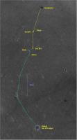
Here is an updated map of the road to Vostok.
Attached thumbnail(s)
|
|
 |
 
|
|
 |
|
Jan 4 2018, 08:36 PM
Post
#3502
|
||
|
Solar System Cartographer Group: Members Posts: 10196 Joined: 5-April 05 From: Canada Member No.: 227 |
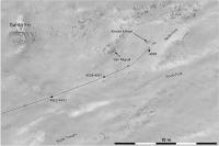
As Fredk said in another thread, we are taking the northern route around the elongated feature in the channel. The new pictures suggest it is a rock outcrop which diverted flow rather than a depositional feature (bar), though it has since weathered until it may no longer be a positive relief feature.
Phil
-------------------- ... because the Solar System ain't gonna map itself.
Also to be found posting similar content on https://mastodon.social/@PhilStooke Maps for download (free PD: https://upload.wikimedia.org/wikipedia/comm...Cartography.pdf NOTE: everything created by me which I post on UMSF is considered to be in the public domain (NOT CC, public domain) |
|
|
|
|
|
 Pando Opportunity Route Map Feb 11 2005, 08:11 AM
 Phil Stooke Getting close to the steeper slope down off Cape T... Mar 27 2017, 01:58 PM Phil Stooke Approximate location after the sol 4686 drive.
Ph... Mar 31 2017, 12:58 PM Phil Stooke Oops, a bit off track with the last drive. Here... Apr 2 2017, 04:48 PM Phil Stooke Nearly at the bottom now, 27 m on sol 4691.
Phil
... Apr 5 2017, 11:32 AM Phil Stooke And another 14 m on sol 4693.
Phil
Apr 7 2017, 01:06 PM Phil Stooke Almost 40 m on sol 4695, and we are off Cape Tribu... Apr 9 2017, 11:58 AM Phil Stooke A very small move on sol 4699 - this map has some ... Apr 13 2017, 04:43 PM Phil Stooke Update to sol 4705. Wherein I make the prepostero... Apr 19 2017, 07:41 PM Phil Stooke We trundled another 19 m south on sol 4706.
Phil
... Apr 21 2017, 12:39 AM Phil Stooke Tootling along at a fine old clip on sol 4708, cov... Apr 22 2017, 07:46 PM Phil Stooke 36 m south to the edge of that little crater on so... Apr 25 2017, 08:44 PM Phil Stooke I've updated recent positions and added today... May 1 2017, 05:29 PM Phil Stooke Sol 4718, a 32 m drive and we are almost there. N... May 3 2017, 12:57 PM Phil Stooke OK, we are looking down the slope a bit. But the ... May 5 2017, 02:31 PM
Phil Stooke Getting close to the steeper slope down off Cape T... Mar 27 2017, 01:58 PM Phil Stooke Approximate location after the sol 4686 drive.
Ph... Mar 31 2017, 12:58 PM Phil Stooke Oops, a bit off track with the last drive. Here... Apr 2 2017, 04:48 PM Phil Stooke Nearly at the bottom now, 27 m on sol 4691.
Phil
... Apr 5 2017, 11:32 AM Phil Stooke And another 14 m on sol 4693.
Phil
Apr 7 2017, 01:06 PM Phil Stooke Almost 40 m on sol 4695, and we are off Cape Tribu... Apr 9 2017, 11:58 AM Phil Stooke A very small move on sol 4699 - this map has some ... Apr 13 2017, 04:43 PM Phil Stooke Update to sol 4705. Wherein I make the prepostero... Apr 19 2017, 07:41 PM Phil Stooke We trundled another 19 m south on sol 4706.
Phil
... Apr 21 2017, 12:39 AM Phil Stooke Tootling along at a fine old clip on sol 4708, cov... Apr 22 2017, 07:46 PM Phil Stooke 36 m south to the edge of that little crater on so... Apr 25 2017, 08:44 PM Phil Stooke I've updated recent positions and added today... May 1 2017, 05:29 PM Phil Stooke Sol 4718, a 32 m drive and we are almost there. N... May 3 2017, 12:57 PM Phil Stooke OK, we are looking down the slope a bit. But the ... May 5 2017, 02:31 PM
 BuckGalaxy QUOTE (Phil Stooke @ May 5 2017, 06:31 AM... May 22 2017, 11:29 PM serpens "The valley campaign". Now there is an ... May 7 2017, 03:25 AM Phil Stooke On the move... sol 4730 - we just moved north and ... May 15 2017, 02:00 PM Phil Stooke Apparently we drove 43 m south on sol 4734 - I wil... May 19 2017, 09:10 PM Phil Stooke Back in the saddle again - did i say saddle? I mea... May 28 2017, 03:15 AM Phil Stooke Another drive on sol 4746, exploring the area at t... Jun 1 2017, 03:48 AM Phil Stooke Two rovers on the move today! Here's an u... Jun 8 2017, 02:41 AM Phil Stooke Back on the move, just about 6 m so far. But at l... Jun 21 2017, 04:15 PM Phil Stooke Update to sol 4767 with a few corrections from Lar... Jun 22 2017, 10:33 PM Phil Stooke updated to sol 4769 with a correction to the last ... Jun 24 2017, 10:31 PM Phil Stooke OK, big new map for the walk-about. I have had tr... Jun 27 2017, 09:25 PM RoverDriver QUOTE (Phil Stooke @ Jun 27 2017, 02:25 P... Jun 27 2017, 09:51 PM Phil Stooke Thanks, Paolo. I assumed (being a cartographer) t... Jun 28 2017, 11:40 PM RoverDriver QUOTE (Phil Stooke @ Jun 28 2017, 04:40 P... Jul 1 2017, 11:03 AM Phil Stooke Another drive on sol 4774 to approach the north ma... Jun 30 2017, 08:59 PM Phil Stooke It's just this cartographer you have to be war... Jul 4 2017, 10:50 PM Phil Stooke A 13 m drive on sol 4781 brings us over the lip an... Jul 6 2017, 10:31 PM Phil Stooke It's Buy One - Get One Free week here in the O... Jul 9 2017, 12:36 AM Phil Stooke A post-conjunction drive for Opportunity on sol 48... Aug 8 2017, 11:40 PM Phil Stooke There was a very small move on sol 4814, mostly a ... Aug 11 2017, 03:14 AM Phil Stooke Another 10 m down the slope on sol 4816.
Phil
Aug 11 2017, 05:16 PM Phil Stooke Sol 4831 - we moved 25 m down the valley to anothe... Aug 27 2017, 06:59 AM Phil Stooke Sol 4834, a move of about 4 m uphill and to the so... Aug 30 2017, 04:37 PM RoverDriver QUOTE (Phil Stooke @ Aug 30 2017, 08:37 A... Aug 30 2017, 09:49 PM Phil Stooke As we know, zombies stagger around groaning ... Sep 26 2017, 11:32 AM HSchirmer QUOTE (Phil Stooke @ Sep 26 2017, 12:32 P... Sep 26 2017, 11:47 AM Phil Stooke You may be right!
A drive uphill on sol 4874,... Oct 10 2017, 09:26 AM Phil Stooke I am ignoring the small move on sol 4883, which wa... Oct 21 2017, 07:32 PM Phil Stooke Another 3 m or so downslope on sol 4890. EDIT - n... Oct 26 2017, 08:10 PM Phil Stooke Here is the final result of that mapping I was ill... Oct 29 2017, 06:15 PM Phil Stooke A drive on sol 4907 to another part of the rocky o... Nov 15 2017, 01:08 AM Phil Stooke We drove again on sol 4922, nearly 15 m further do... Nov 28 2017, 08:47 PM Phil Stooke Strolling down the valley again on sol 4934... tow... Dec 12 2017, 01:39 AM Phil Stooke No new drive yet but a new close-up map of this ar... Dec 24 2017, 09:28 PM Phil Stooke Update to sol 4968, with a drive to the north to l... Jan 20 2018, 11:34 PM Phil Stooke About a 1 m drive on sol 4975 to interesting rocks... Jan 23 2018, 11:27 PM fredk Luckily http://curiosityrover.com/ is back in oper... Jan 23 2018, 11:59 PM Phil Stooke No move, but an updated map. Locations of many na... Feb 5 2018, 08:31 PM Phil Stooke We had a drive of a few meters on sol 4990, backin... Feb 7 2018, 07:17 PM RoverDriver QUOTE (Phil Stooke @ Feb 7 2018, 11:17 AM... Feb 7 2018, 07:59 PM Phil Stooke Thanks! Here is the 4991 position - though I ... Feb 7 2018, 11:16 PM Phil Stooke Update to sol 4993, and on sol 4994 the MI was use... Feb 10 2018, 10:53 PM Phil Stooke Whoa! Sprinting uphill on sol 4997. I didn... Feb 13 2018, 10:21 PM RoverDriver QUOTE (Phil Stooke @ Feb 13 2018, 02:21 P... Feb 14 2018, 01:43 AM Phil Stooke Here is an overview of the valley activities - we... Feb 15 2018, 08:04 PM Phil Stooke A short drive downhill to the tip of the outcrop o... Mar 5 2018, 11:23 PM Phil Stooke A small move, 40 cm, on sol 5023. I have moved a ... Mar 13 2018, 12:11 AM Phil Stooke Update to sol 5038. A short drive to the NW.
Phi... Mar 28 2018, 09:46 PM Phil Stooke And that short drive was preparing for this - a 4 ... Mar 29 2018, 08:57 PM Phil Stooke This area is so interesting that we just moved bac... Apr 16 2018, 03:13 PM Phil Stooke Sol 5058, another short drive to reach the next ta... Apr 18 2018, 03:48 PM Phil Stooke Sol 5060, Opportunity moves a meter on Mars so I h... Apr 19 2018, 05:05 PM HSchirmer QUOTE (Phil Stooke @ Apr 19 2018, 06:05 P... Apr 19 2018, 06:26 PM RoverDriver QUOTE (HSchirmer @ Apr 19 2018, 11:26 AM)... Apr 20 2018, 11:56 AM fredk The scale on Phil's map shows that Oppy's ... Apr 19 2018, 07:43 PM HSchirmer QUOTE (fredk @ Apr 19 2018, 07:43 PM) The... Apr 19 2018, 07:55 PM Phil Stooke All Mars rovers have done pivots in place, leaving... Apr 19 2018, 09:01 PM Phil Stooke A small move to the north on sol 5063.
Phil
Apr 22 2018, 04:08 PM RoverDriver The Sol 5063 drive objective was to do a (almost) ... Apr 22 2018, 09:20 PM Phil Stooke Made it! Nearly 10 m uphill on sol 5065.
Phi... Apr 24 2018, 10:24 PM Phil Stooke And now an adjustment to reach the next interestin... Apr 25 2018, 05:42 PM Phil Stooke A short approach drive on sol 5068 to reach the ne... Apr 27 2018, 05:47 PM Phil Stooke A very small adjustment in position today - sol 50... Apr 30 2018, 04:08 AM Phil Stooke We pulled back from the outcrop on sol 5074.
Phil... May 3 2018, 08:00 PM Phil Stooke A 3 m drive to reach another interesting rock on s... May 6 2018, 07:46 PM Phil Stooke Sol 5083, a small move to reach new targets.
Phil... May 13 2018, 03:54 AM Phil Stooke No new drive, but to celebrate sol 5100, a new bas... May 30 2018, 07:59 PM ajsrayl QUOTE (Phil Stooke @ May 30 2018, 11:59 A... Jun 16 2018, 01:38 PM nprev That was a fast 100 sols... May 31 2018, 04:34 AM John Moore As always, thanks, Phil...for these maps...so expl... May 31 2018, 07:02 AM Floyd Many thanks AJS Rayl for the MER Updates every mo... Jun 16 2018, 04:56 PM RoverDriver Q: What does a bored rover driver do?
A: Looks bac... Jun 19 2018, 12:00 AM vikingmars QUOTE (RoverDriver @ Jun 19 2018, 02:00 A... Jun 20 2018, 05:48 AM jccwrt Here's a big project I've been working on.... Jan 12 2019, 05:57 AM atomoid QUOTE (jccwrt @ Jan 11 2019, 09:57 PM) ..... Jan 14 2019, 10:00 PM RoverDriver QUOTE (atomoid @ Jan 14 2019, 02:00 PM) .... Jan 16 2019, 12:11 AM marsophile QUOTE (RoverDriver @ Jan 15 2019, 04:11 P... Jan 18 2019, 07:54 AM RoverDriver QUOTE (marsophile @ Jan 17 2019, 11:54 PM... Jan 18 2019, 02:37 PM Phil Stooke Really beautiful work, Justin.
Phil Jan 12 2019, 11:01 PM SFJCody QUOTE (Phil Stooke @ Jan 13 2019, 10:01 A... Jan 13 2019, 03:38 AM John Moore Wonderful: puts the mission's path in perspect... Jan 18 2019, 08:01 AM rtphokie Does this sound right as a final position?
2°19... Feb 14 2019, 12:25 PM sranderson So, we'll go no more a roving
So late into ... Jan 23 2020, 09:55 PM
BuckGalaxy QUOTE (Phil Stooke @ May 5 2017, 06:31 AM... May 22 2017, 11:29 PM serpens "The valley campaign". Now there is an ... May 7 2017, 03:25 AM Phil Stooke On the move... sol 4730 - we just moved north and ... May 15 2017, 02:00 PM Phil Stooke Apparently we drove 43 m south on sol 4734 - I wil... May 19 2017, 09:10 PM Phil Stooke Back in the saddle again - did i say saddle? I mea... May 28 2017, 03:15 AM Phil Stooke Another drive on sol 4746, exploring the area at t... Jun 1 2017, 03:48 AM Phil Stooke Two rovers on the move today! Here's an u... Jun 8 2017, 02:41 AM Phil Stooke Back on the move, just about 6 m so far. But at l... Jun 21 2017, 04:15 PM Phil Stooke Update to sol 4767 with a few corrections from Lar... Jun 22 2017, 10:33 PM Phil Stooke updated to sol 4769 with a correction to the last ... Jun 24 2017, 10:31 PM Phil Stooke OK, big new map for the walk-about. I have had tr... Jun 27 2017, 09:25 PM RoverDriver QUOTE (Phil Stooke @ Jun 27 2017, 02:25 P... Jun 27 2017, 09:51 PM Phil Stooke Thanks, Paolo. I assumed (being a cartographer) t... Jun 28 2017, 11:40 PM RoverDriver QUOTE (Phil Stooke @ Jun 28 2017, 04:40 P... Jul 1 2017, 11:03 AM Phil Stooke Another drive on sol 4774 to approach the north ma... Jun 30 2017, 08:59 PM Phil Stooke It's just this cartographer you have to be war... Jul 4 2017, 10:50 PM Phil Stooke A 13 m drive on sol 4781 brings us over the lip an... Jul 6 2017, 10:31 PM Phil Stooke It's Buy One - Get One Free week here in the O... Jul 9 2017, 12:36 AM Phil Stooke A post-conjunction drive for Opportunity on sol 48... Aug 8 2017, 11:40 PM Phil Stooke There was a very small move on sol 4814, mostly a ... Aug 11 2017, 03:14 AM Phil Stooke Another 10 m down the slope on sol 4816.
Phil
Aug 11 2017, 05:16 PM Phil Stooke Sol 4831 - we moved 25 m down the valley to anothe... Aug 27 2017, 06:59 AM Phil Stooke Sol 4834, a move of about 4 m uphill and to the so... Aug 30 2017, 04:37 PM RoverDriver QUOTE (Phil Stooke @ Aug 30 2017, 08:37 A... Aug 30 2017, 09:49 PM Phil Stooke As we know, zombies stagger around groaning ... Sep 26 2017, 11:32 AM HSchirmer QUOTE (Phil Stooke @ Sep 26 2017, 12:32 P... Sep 26 2017, 11:47 AM Phil Stooke You may be right!
A drive uphill on sol 4874,... Oct 10 2017, 09:26 AM Phil Stooke I am ignoring the small move on sol 4883, which wa... Oct 21 2017, 07:32 PM Phil Stooke Another 3 m or so downslope on sol 4890. EDIT - n... Oct 26 2017, 08:10 PM Phil Stooke Here is the final result of that mapping I was ill... Oct 29 2017, 06:15 PM Phil Stooke A drive on sol 4907 to another part of the rocky o... Nov 15 2017, 01:08 AM Phil Stooke We drove again on sol 4922, nearly 15 m further do... Nov 28 2017, 08:47 PM Phil Stooke Strolling down the valley again on sol 4934... tow... Dec 12 2017, 01:39 AM Phil Stooke No new drive yet but a new close-up map of this ar... Dec 24 2017, 09:28 PM Phil Stooke Update to sol 4968, with a drive to the north to l... Jan 20 2018, 11:34 PM Phil Stooke About a 1 m drive on sol 4975 to interesting rocks... Jan 23 2018, 11:27 PM fredk Luckily http://curiosityrover.com/ is back in oper... Jan 23 2018, 11:59 PM Phil Stooke No move, but an updated map. Locations of many na... Feb 5 2018, 08:31 PM Phil Stooke We had a drive of a few meters on sol 4990, backin... Feb 7 2018, 07:17 PM RoverDriver QUOTE (Phil Stooke @ Feb 7 2018, 11:17 AM... Feb 7 2018, 07:59 PM Phil Stooke Thanks! Here is the 4991 position - though I ... Feb 7 2018, 11:16 PM Phil Stooke Update to sol 4993, and on sol 4994 the MI was use... Feb 10 2018, 10:53 PM Phil Stooke Whoa! Sprinting uphill on sol 4997. I didn... Feb 13 2018, 10:21 PM RoverDriver QUOTE (Phil Stooke @ Feb 13 2018, 02:21 P... Feb 14 2018, 01:43 AM Phil Stooke Here is an overview of the valley activities - we... Feb 15 2018, 08:04 PM Phil Stooke A short drive downhill to the tip of the outcrop o... Mar 5 2018, 11:23 PM Phil Stooke A small move, 40 cm, on sol 5023. I have moved a ... Mar 13 2018, 12:11 AM Phil Stooke Update to sol 5038. A short drive to the NW.
Phi... Mar 28 2018, 09:46 PM Phil Stooke And that short drive was preparing for this - a 4 ... Mar 29 2018, 08:57 PM Phil Stooke This area is so interesting that we just moved bac... Apr 16 2018, 03:13 PM Phil Stooke Sol 5058, another short drive to reach the next ta... Apr 18 2018, 03:48 PM Phil Stooke Sol 5060, Opportunity moves a meter on Mars so I h... Apr 19 2018, 05:05 PM HSchirmer QUOTE (Phil Stooke @ Apr 19 2018, 06:05 P... Apr 19 2018, 06:26 PM RoverDriver QUOTE (HSchirmer @ Apr 19 2018, 11:26 AM)... Apr 20 2018, 11:56 AM fredk The scale on Phil's map shows that Oppy's ... Apr 19 2018, 07:43 PM HSchirmer QUOTE (fredk @ Apr 19 2018, 07:43 PM) The... Apr 19 2018, 07:55 PM Phil Stooke All Mars rovers have done pivots in place, leaving... Apr 19 2018, 09:01 PM Phil Stooke A small move to the north on sol 5063.
Phil
Apr 22 2018, 04:08 PM RoverDriver The Sol 5063 drive objective was to do a (almost) ... Apr 22 2018, 09:20 PM Phil Stooke Made it! Nearly 10 m uphill on sol 5065.
Phi... Apr 24 2018, 10:24 PM Phil Stooke And now an adjustment to reach the next interestin... Apr 25 2018, 05:42 PM Phil Stooke A short approach drive on sol 5068 to reach the ne... Apr 27 2018, 05:47 PM Phil Stooke A very small adjustment in position today - sol 50... Apr 30 2018, 04:08 AM Phil Stooke We pulled back from the outcrop on sol 5074.
Phil... May 3 2018, 08:00 PM Phil Stooke A 3 m drive to reach another interesting rock on s... May 6 2018, 07:46 PM Phil Stooke Sol 5083, a small move to reach new targets.
Phil... May 13 2018, 03:54 AM Phil Stooke No new drive, but to celebrate sol 5100, a new bas... May 30 2018, 07:59 PM ajsrayl QUOTE (Phil Stooke @ May 30 2018, 11:59 A... Jun 16 2018, 01:38 PM nprev That was a fast 100 sols... May 31 2018, 04:34 AM John Moore As always, thanks, Phil...for these maps...so expl... May 31 2018, 07:02 AM Floyd Many thanks AJS Rayl for the MER Updates every mo... Jun 16 2018, 04:56 PM RoverDriver Q: What does a bored rover driver do?
A: Looks bac... Jun 19 2018, 12:00 AM vikingmars QUOTE (RoverDriver @ Jun 19 2018, 02:00 A... Jun 20 2018, 05:48 AM jccwrt Here's a big project I've been working on.... Jan 12 2019, 05:57 AM atomoid QUOTE (jccwrt @ Jan 11 2019, 09:57 PM) ..... Jan 14 2019, 10:00 PM RoverDriver QUOTE (atomoid @ Jan 14 2019, 02:00 PM) .... Jan 16 2019, 12:11 AM marsophile QUOTE (RoverDriver @ Jan 15 2019, 04:11 P... Jan 18 2019, 07:54 AM RoverDriver QUOTE (marsophile @ Jan 17 2019, 11:54 PM... Jan 18 2019, 02:37 PM Phil Stooke Really beautiful work, Justin.
Phil Jan 12 2019, 11:01 PM SFJCody QUOTE (Phil Stooke @ Jan 13 2019, 10:01 A... Jan 13 2019, 03:38 AM John Moore Wonderful: puts the mission's path in perspect... Jan 18 2019, 08:01 AM rtphokie Does this sound right as a final position?
2°19... Feb 14 2019, 12:25 PM sranderson So, we'll go no more a roving
So late into ... Jan 23 2020, 09:55 PM |

|
Lo-Fi Version | Time is now: 22nd June 2024 - 08:45 AM |
|
RULES AND GUIDELINES Please read the Forum Rules and Guidelines before posting. IMAGE COPYRIGHT |
OPINIONS AND MODERATION Opinions expressed on UnmannedSpaceflight.com are those of the individual posters and do not necessarily reflect the opinions of UnmannedSpaceflight.com or The Planetary Society. The all-volunteer UnmannedSpaceflight.com moderation team is wholly independent of The Planetary Society. The Planetary Society has no influence over decisions made by the UnmannedSpaceflight.com moderators. |
SUPPORT THE FORUM Unmannedspaceflight.com is funded by the Planetary Society. Please consider supporting our work and many other projects by donating to the Society or becoming a member. |
|