Opportunity Route Map |

Opportunity Route Map |
 Feb 11 2005, 08:11 AM Feb 11 2005, 08:11 AM
Post
#3501
|
||
 The Insider  Group: Members Posts: 669 Joined: 3-May 04 Member No.: 73 |
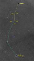
Here is an updated map of the road to Vostok.
Attached thumbnail(s)
|
|
 |
 
|
|
 |
|
Feb 13 2018, 10:21 PM
Post
#3502
|
||
|
Solar System Cartographer Group: Members Posts: 10226 Joined: 5-April 05 From: Canada Member No.: 227 |
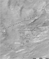
Whoa! Sprinting uphill on sol 4997. I didn't see that coming. Sort of diagonally across the hill really, but maybe we will take that South Fork now. Who shot JR? (digital Mars Bar to anyone who has the faintest idea what I am talking about - but no replies to this thread please!).
Phil
-------------------- ... because the Solar System ain't gonna map itself.
Also to be found posting similar content on https://mastodon.social/@PhilStooke Maps for download (free PDF: https://upload.wikimedia.org/wikipedia/comm...Cartography.pdf NOTE: everything created by me which I post on UMSF is considered to be in the public domain (NOT CC, public domain) |
|
|
|
|
|
 Pando Opportunity Route Map Feb 11 2005, 08:11 AM
 Phil Stooke Getting close to the steeper slope down off Cape T... Mar 27 2017, 01:58 PM Phil Stooke Approximate location after the sol 4686 drive.
Ph... Mar 31 2017, 12:58 PM Phil Stooke Oops, a bit off track with the last drive. Here... Apr 2 2017, 04:48 PM Phil Stooke Nearly at the bottom now, 27 m on sol 4691.
Phil
... Apr 5 2017, 11:32 AM Phil Stooke And another 14 m on sol 4693.
Phil
Apr 7 2017, 01:06 PM Phil Stooke Almost 40 m on sol 4695, and we are off Cape Tribu... Apr 9 2017, 11:58 AM Phil Stooke A very small move on sol 4699 - this map has some ... Apr 13 2017, 04:43 PM Phil Stooke Update to sol 4705. Wherein I make the prepostero... Apr 19 2017, 07:41 PM Phil Stooke We trundled another 19 m south on sol 4706.
Phil
... Apr 21 2017, 12:39 AM Phil Stooke Tootling along at a fine old clip on sol 4708, cov... Apr 22 2017, 07:46 PM Phil Stooke 36 m south to the edge of that little crater on so... Apr 25 2017, 08:44 PM Phil Stooke I've updated recent positions and added today... May 1 2017, 05:29 PM Phil Stooke Sol 4718, a 32 m drive and we are almost there. N... May 3 2017, 12:57 PM Phil Stooke OK, we are looking down the slope a bit. But the ... May 5 2017, 02:31 PM
Phil Stooke Getting close to the steeper slope down off Cape T... Mar 27 2017, 01:58 PM Phil Stooke Approximate location after the sol 4686 drive.
Ph... Mar 31 2017, 12:58 PM Phil Stooke Oops, a bit off track with the last drive. Here... Apr 2 2017, 04:48 PM Phil Stooke Nearly at the bottom now, 27 m on sol 4691.
Phil
... Apr 5 2017, 11:32 AM Phil Stooke And another 14 m on sol 4693.
Phil
Apr 7 2017, 01:06 PM Phil Stooke Almost 40 m on sol 4695, and we are off Cape Tribu... Apr 9 2017, 11:58 AM Phil Stooke A very small move on sol 4699 - this map has some ... Apr 13 2017, 04:43 PM Phil Stooke Update to sol 4705. Wherein I make the prepostero... Apr 19 2017, 07:41 PM Phil Stooke We trundled another 19 m south on sol 4706.
Phil
... Apr 21 2017, 12:39 AM Phil Stooke Tootling along at a fine old clip on sol 4708, cov... Apr 22 2017, 07:46 PM Phil Stooke 36 m south to the edge of that little crater on so... Apr 25 2017, 08:44 PM Phil Stooke I've updated recent positions and added today... May 1 2017, 05:29 PM Phil Stooke Sol 4718, a 32 m drive and we are almost there. N... May 3 2017, 12:57 PM Phil Stooke OK, we are looking down the slope a bit. But the ... May 5 2017, 02:31 PM
 BuckGalaxy QUOTE (Phil Stooke @ May 5 2017, 06:31 AM... May 22 2017, 11:29 PM serpens "The valley campaign". Now there is an ... May 7 2017, 03:25 AM Phil Stooke On the move... sol 4730 - we just moved north and ... May 15 2017, 02:00 PM Phil Stooke Apparently we drove 43 m south on sol 4734 - I wil... May 19 2017, 09:10 PM Phil Stooke Back in the saddle again - did i say saddle? I mea... May 28 2017, 03:15 AM Phil Stooke Another drive on sol 4746, exploring the area at t... Jun 1 2017, 03:48 AM Phil Stooke Two rovers on the move today! Here's an u... Jun 8 2017, 02:41 AM Phil Stooke Back on the move, just about 6 m so far. But at l... Jun 21 2017, 04:15 PM Phil Stooke Update to sol 4767 with a few corrections from Lar... Jun 22 2017, 10:33 PM Phil Stooke updated to sol 4769 with a correction to the last ... Jun 24 2017, 10:31 PM Phil Stooke OK, big new map for the walk-about. I have had tr... Jun 27 2017, 09:25 PM RoverDriver QUOTE (Phil Stooke @ Jun 27 2017, 02:25 P... Jun 27 2017, 09:51 PM Phil Stooke Thanks, Paolo. I assumed (being a cartographer) t... Jun 28 2017, 11:40 PM RoverDriver QUOTE (Phil Stooke @ Jun 28 2017, 04:40 P... Jul 1 2017, 11:03 AM Phil Stooke Another drive on sol 4774 to approach the north ma... Jun 30 2017, 08:59 PM Phil Stooke It's just this cartographer you have to be war... Jul 4 2017, 10:50 PM Phil Stooke A 13 m drive on sol 4781 brings us over the lip an... Jul 6 2017, 10:31 PM Phil Stooke It's Buy One - Get One Free week here in the O... Jul 9 2017, 12:36 AM Phil Stooke A post-conjunction drive for Opportunity on sol 48... Aug 8 2017, 11:40 PM Phil Stooke There was a very small move on sol 4814, mostly a ... Aug 11 2017, 03:14 AM Phil Stooke Another 10 m down the slope on sol 4816.
Phil
Aug 11 2017, 05:16 PM Phil Stooke Sol 4831 - we moved 25 m down the valley to anothe... Aug 27 2017, 06:59 AM Phil Stooke Sol 4834, a move of about 4 m uphill and to the so... Aug 30 2017, 04:37 PM RoverDriver QUOTE (Phil Stooke @ Aug 30 2017, 08:37 A... Aug 30 2017, 09:49 PM Phil Stooke As we know, zombies stagger around groaning ... Sep 26 2017, 11:32 AM HSchirmer QUOTE (Phil Stooke @ Sep 26 2017, 12:32 P... Sep 26 2017, 11:47 AM Phil Stooke You may be right!
A drive uphill on sol 4874,... Oct 10 2017, 09:26 AM Phil Stooke I am ignoring the small move on sol 4883, which wa... Oct 21 2017, 07:32 PM Phil Stooke Another 3 m or so downslope on sol 4890. EDIT - n... Oct 26 2017, 08:10 PM Phil Stooke Here is the final result of that mapping I was ill... Oct 29 2017, 06:15 PM Phil Stooke A drive on sol 4907 to another part of the rocky o... Nov 15 2017, 01:08 AM Phil Stooke We drove again on sol 4922, nearly 15 m further do... Nov 28 2017, 08:47 PM Phil Stooke Strolling down the valley again on sol 4934... tow... Dec 12 2017, 01:39 AM Phil Stooke No new drive yet but a new close-up map of this ar... Dec 24 2017, 09:28 PM Phil Stooke As Fredk said in another thread, we are taking the... Jan 4 2018, 08:36 PM Phil Stooke Update to sol 4968, with a drive to the north to l... Jan 20 2018, 11:34 PM Phil Stooke About a 1 m drive on sol 4975 to interesting rocks... Jan 23 2018, 11:27 PM fredk Luckily http://curiosityrover.com/ is back in oper... Jan 23 2018, 11:59 PM Phil Stooke No move, but an updated map. Locations of many na... Feb 5 2018, 08:31 PM Phil Stooke We had a drive of a few meters on sol 4990, backin... Feb 7 2018, 07:17 PM RoverDriver QUOTE (Phil Stooke @ Feb 7 2018, 11:17 AM... Feb 7 2018, 07:59 PM Phil Stooke Thanks! Here is the 4991 position - though I ... Feb 7 2018, 11:16 PM Phil Stooke Update to sol 4993, and on sol 4994 the MI was use... Feb 10 2018, 10:53 PM RoverDriver QUOTE (Phil Stooke @ Feb 13 2018, 02:21 P... Feb 14 2018, 01:43 AM Phil Stooke Here is an overview of the valley activities - we... Feb 15 2018, 08:04 PM Phil Stooke A short drive downhill to the tip of the outcrop o... Mar 5 2018, 11:23 PM Phil Stooke A small move, 40 cm, on sol 5023. I have moved a ... Mar 13 2018, 12:11 AM Phil Stooke Update to sol 5038. A short drive to the NW.
Phi... Mar 28 2018, 09:46 PM Phil Stooke And that short drive was preparing for this - a 4 ... Mar 29 2018, 08:57 PM Phil Stooke This area is so interesting that we just moved bac... Apr 16 2018, 03:13 PM Phil Stooke Sol 5058, another short drive to reach the next ta... Apr 18 2018, 03:48 PM Phil Stooke Sol 5060, Opportunity moves a meter on Mars so I h... Apr 19 2018, 05:05 PM HSchirmer QUOTE (Phil Stooke @ Apr 19 2018, 06:05 P... Apr 19 2018, 06:26 PM RoverDriver QUOTE (HSchirmer @ Apr 19 2018, 11:26 AM)... Apr 20 2018, 11:56 AM fredk The scale on Phil's map shows that Oppy's ... Apr 19 2018, 07:43 PM HSchirmer QUOTE (fredk @ Apr 19 2018, 07:43 PM) The... Apr 19 2018, 07:55 PM Phil Stooke All Mars rovers have done pivots in place, leaving... Apr 19 2018, 09:01 PM Phil Stooke A small move to the north on sol 5063.
Phil
Apr 22 2018, 04:08 PM RoverDriver The Sol 5063 drive objective was to do a (almost) ... Apr 22 2018, 09:20 PM Phil Stooke Made it! Nearly 10 m uphill on sol 5065.
Phi... Apr 24 2018, 10:24 PM Phil Stooke And now an adjustment to reach the next interestin... Apr 25 2018, 05:42 PM Phil Stooke A short approach drive on sol 5068 to reach the ne... Apr 27 2018, 05:47 PM Phil Stooke A very small adjustment in position today - sol 50... Apr 30 2018, 04:08 AM Phil Stooke We pulled back from the outcrop on sol 5074.
Phil... May 3 2018, 08:00 PM Phil Stooke A 3 m drive to reach another interesting rock on s... May 6 2018, 07:46 PM Phil Stooke Sol 5083, a small move to reach new targets.
Phil... May 13 2018, 03:54 AM Phil Stooke No new drive, but to celebrate sol 5100, a new bas... May 30 2018, 07:59 PM ajsrayl QUOTE (Phil Stooke @ May 30 2018, 11:59 A... Jun 16 2018, 01:38 PM nprev That was a fast 100 sols... May 31 2018, 04:34 AM John Moore As always, thanks, Phil...for these maps...so expl... May 31 2018, 07:02 AM Floyd Many thanks AJS Rayl for the MER Updates every mo... Jun 16 2018, 04:56 PM RoverDriver Q: What does a bored rover driver do?
A: Looks bac... Jun 19 2018, 12:00 AM vikingmars QUOTE (RoverDriver @ Jun 19 2018, 02:00 A... Jun 20 2018, 05:48 AM jccwrt Here's a big project I've been working on.... Jan 12 2019, 05:57 AM atomoid QUOTE (jccwrt @ Jan 11 2019, 09:57 PM) ..... Jan 14 2019, 10:00 PM RoverDriver QUOTE (atomoid @ Jan 14 2019, 02:00 PM) .... Jan 16 2019, 12:11 AM marsophile QUOTE (RoverDriver @ Jan 15 2019, 04:11 P... Jan 18 2019, 07:54 AM RoverDriver QUOTE (marsophile @ Jan 17 2019, 11:54 PM... Jan 18 2019, 02:37 PM Phil Stooke Really beautiful work, Justin.
Phil Jan 12 2019, 11:01 PM SFJCody QUOTE (Phil Stooke @ Jan 13 2019, 10:01 A... Jan 13 2019, 03:38 AM John Moore Wonderful: puts the mission's path in perspect... Jan 18 2019, 08:01 AM rtphokie Does this sound right as a final position?
2°19... Feb 14 2019, 12:25 PM sranderson So, we'll go no more a roving
So late into ... Jan 23 2020, 09:55 PM
BuckGalaxy QUOTE (Phil Stooke @ May 5 2017, 06:31 AM... May 22 2017, 11:29 PM serpens "The valley campaign". Now there is an ... May 7 2017, 03:25 AM Phil Stooke On the move... sol 4730 - we just moved north and ... May 15 2017, 02:00 PM Phil Stooke Apparently we drove 43 m south on sol 4734 - I wil... May 19 2017, 09:10 PM Phil Stooke Back in the saddle again - did i say saddle? I mea... May 28 2017, 03:15 AM Phil Stooke Another drive on sol 4746, exploring the area at t... Jun 1 2017, 03:48 AM Phil Stooke Two rovers on the move today! Here's an u... Jun 8 2017, 02:41 AM Phil Stooke Back on the move, just about 6 m so far. But at l... Jun 21 2017, 04:15 PM Phil Stooke Update to sol 4767 with a few corrections from Lar... Jun 22 2017, 10:33 PM Phil Stooke updated to sol 4769 with a correction to the last ... Jun 24 2017, 10:31 PM Phil Stooke OK, big new map for the walk-about. I have had tr... Jun 27 2017, 09:25 PM RoverDriver QUOTE (Phil Stooke @ Jun 27 2017, 02:25 P... Jun 27 2017, 09:51 PM Phil Stooke Thanks, Paolo. I assumed (being a cartographer) t... Jun 28 2017, 11:40 PM RoverDriver QUOTE (Phil Stooke @ Jun 28 2017, 04:40 P... Jul 1 2017, 11:03 AM Phil Stooke Another drive on sol 4774 to approach the north ma... Jun 30 2017, 08:59 PM Phil Stooke It's just this cartographer you have to be war... Jul 4 2017, 10:50 PM Phil Stooke A 13 m drive on sol 4781 brings us over the lip an... Jul 6 2017, 10:31 PM Phil Stooke It's Buy One - Get One Free week here in the O... Jul 9 2017, 12:36 AM Phil Stooke A post-conjunction drive for Opportunity on sol 48... Aug 8 2017, 11:40 PM Phil Stooke There was a very small move on sol 4814, mostly a ... Aug 11 2017, 03:14 AM Phil Stooke Another 10 m down the slope on sol 4816.
Phil
Aug 11 2017, 05:16 PM Phil Stooke Sol 4831 - we moved 25 m down the valley to anothe... Aug 27 2017, 06:59 AM Phil Stooke Sol 4834, a move of about 4 m uphill and to the so... Aug 30 2017, 04:37 PM RoverDriver QUOTE (Phil Stooke @ Aug 30 2017, 08:37 A... Aug 30 2017, 09:49 PM Phil Stooke As we know, zombies stagger around groaning ... Sep 26 2017, 11:32 AM HSchirmer QUOTE (Phil Stooke @ Sep 26 2017, 12:32 P... Sep 26 2017, 11:47 AM Phil Stooke You may be right!
A drive uphill on sol 4874,... Oct 10 2017, 09:26 AM Phil Stooke I am ignoring the small move on sol 4883, which wa... Oct 21 2017, 07:32 PM Phil Stooke Another 3 m or so downslope on sol 4890. EDIT - n... Oct 26 2017, 08:10 PM Phil Stooke Here is the final result of that mapping I was ill... Oct 29 2017, 06:15 PM Phil Stooke A drive on sol 4907 to another part of the rocky o... Nov 15 2017, 01:08 AM Phil Stooke We drove again on sol 4922, nearly 15 m further do... Nov 28 2017, 08:47 PM Phil Stooke Strolling down the valley again on sol 4934... tow... Dec 12 2017, 01:39 AM Phil Stooke No new drive yet but a new close-up map of this ar... Dec 24 2017, 09:28 PM Phil Stooke As Fredk said in another thread, we are taking the... Jan 4 2018, 08:36 PM Phil Stooke Update to sol 4968, with a drive to the north to l... Jan 20 2018, 11:34 PM Phil Stooke About a 1 m drive on sol 4975 to interesting rocks... Jan 23 2018, 11:27 PM fredk Luckily http://curiosityrover.com/ is back in oper... Jan 23 2018, 11:59 PM Phil Stooke No move, but an updated map. Locations of many na... Feb 5 2018, 08:31 PM Phil Stooke We had a drive of a few meters on sol 4990, backin... Feb 7 2018, 07:17 PM RoverDriver QUOTE (Phil Stooke @ Feb 7 2018, 11:17 AM... Feb 7 2018, 07:59 PM Phil Stooke Thanks! Here is the 4991 position - though I ... Feb 7 2018, 11:16 PM Phil Stooke Update to sol 4993, and on sol 4994 the MI was use... Feb 10 2018, 10:53 PM RoverDriver QUOTE (Phil Stooke @ Feb 13 2018, 02:21 P... Feb 14 2018, 01:43 AM Phil Stooke Here is an overview of the valley activities - we... Feb 15 2018, 08:04 PM Phil Stooke A short drive downhill to the tip of the outcrop o... Mar 5 2018, 11:23 PM Phil Stooke A small move, 40 cm, on sol 5023. I have moved a ... Mar 13 2018, 12:11 AM Phil Stooke Update to sol 5038. A short drive to the NW.
Phi... Mar 28 2018, 09:46 PM Phil Stooke And that short drive was preparing for this - a 4 ... Mar 29 2018, 08:57 PM Phil Stooke This area is so interesting that we just moved bac... Apr 16 2018, 03:13 PM Phil Stooke Sol 5058, another short drive to reach the next ta... Apr 18 2018, 03:48 PM Phil Stooke Sol 5060, Opportunity moves a meter on Mars so I h... Apr 19 2018, 05:05 PM HSchirmer QUOTE (Phil Stooke @ Apr 19 2018, 06:05 P... Apr 19 2018, 06:26 PM RoverDriver QUOTE (HSchirmer @ Apr 19 2018, 11:26 AM)... Apr 20 2018, 11:56 AM fredk The scale on Phil's map shows that Oppy's ... Apr 19 2018, 07:43 PM HSchirmer QUOTE (fredk @ Apr 19 2018, 07:43 PM) The... Apr 19 2018, 07:55 PM Phil Stooke All Mars rovers have done pivots in place, leaving... Apr 19 2018, 09:01 PM Phil Stooke A small move to the north on sol 5063.
Phil
Apr 22 2018, 04:08 PM RoverDriver The Sol 5063 drive objective was to do a (almost) ... Apr 22 2018, 09:20 PM Phil Stooke Made it! Nearly 10 m uphill on sol 5065.
Phi... Apr 24 2018, 10:24 PM Phil Stooke And now an adjustment to reach the next interestin... Apr 25 2018, 05:42 PM Phil Stooke A short approach drive on sol 5068 to reach the ne... Apr 27 2018, 05:47 PM Phil Stooke A very small adjustment in position today - sol 50... Apr 30 2018, 04:08 AM Phil Stooke We pulled back from the outcrop on sol 5074.
Phil... May 3 2018, 08:00 PM Phil Stooke A 3 m drive to reach another interesting rock on s... May 6 2018, 07:46 PM Phil Stooke Sol 5083, a small move to reach new targets.
Phil... May 13 2018, 03:54 AM Phil Stooke No new drive, but to celebrate sol 5100, a new bas... May 30 2018, 07:59 PM ajsrayl QUOTE (Phil Stooke @ May 30 2018, 11:59 A... Jun 16 2018, 01:38 PM nprev That was a fast 100 sols... May 31 2018, 04:34 AM John Moore As always, thanks, Phil...for these maps...so expl... May 31 2018, 07:02 AM Floyd Many thanks AJS Rayl for the MER Updates every mo... Jun 16 2018, 04:56 PM RoverDriver Q: What does a bored rover driver do?
A: Looks bac... Jun 19 2018, 12:00 AM vikingmars QUOTE (RoverDriver @ Jun 19 2018, 02:00 A... Jun 20 2018, 05:48 AM jccwrt Here's a big project I've been working on.... Jan 12 2019, 05:57 AM atomoid QUOTE (jccwrt @ Jan 11 2019, 09:57 PM) ..... Jan 14 2019, 10:00 PM RoverDriver QUOTE (atomoid @ Jan 14 2019, 02:00 PM) .... Jan 16 2019, 12:11 AM marsophile QUOTE (RoverDriver @ Jan 15 2019, 04:11 P... Jan 18 2019, 07:54 AM RoverDriver QUOTE (marsophile @ Jan 17 2019, 11:54 PM... Jan 18 2019, 02:37 PM Phil Stooke Really beautiful work, Justin.
Phil Jan 12 2019, 11:01 PM SFJCody QUOTE (Phil Stooke @ Jan 13 2019, 10:01 A... Jan 13 2019, 03:38 AM John Moore Wonderful: puts the mission's path in perspect... Jan 18 2019, 08:01 AM rtphokie Does this sound right as a final position?
2°19... Feb 14 2019, 12:25 PM sranderson So, we'll go no more a roving
So late into ... Jan 23 2020, 09:55 PM |

|
Lo-Fi Version | Time is now: 23rd September 2024 - 12:40 PM |
|
RULES AND GUIDELINES Please read the Forum Rules and Guidelines before posting. IMAGE COPYRIGHT |
OPINIONS AND MODERATION Opinions expressed on UnmannedSpaceflight.com are those of the individual posters and do not necessarily reflect the opinions of UnmannedSpaceflight.com or The Planetary Society. The all-volunteer UnmannedSpaceflight.com moderation team is wholly independent of The Planetary Society. The Planetary Society has no influence over decisions made by the UnmannedSpaceflight.com moderators. |
SUPPORT THE FORUM Unmannedspaceflight.com is funded by the Planetary Society. Please consider supporting our work and many other projects by donating to the Society or becoming a member. |
|