The Martian Sky |

The Martian Sky |
 Oct 11 2009, 06:41 PM Oct 11 2009, 06:41 PM
Post
#1
|
|||
 IMG to PNG GOD  Group: Moderator Posts: 2254 Joined: 19-February 04 From: Near fire and ice Member No.: 38 |
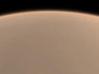
I have been attempting to make computer generated images of the Martian atmosphere, both as seen from the surface and from space. To check the results I have been looking for spacecraft images to use as ground truth. I have found lots of images - by far the best ones I have found are from UMSF in this thread: http://www.unmannedspaceflight.com/index.php?showtopic=3324
However, I'm always looking for more ;-). So if anyone knows of more and/or better images I'm interested in them. What would be best are mosaics showing the sky from the horizon (with the horizon/surface visible) and towards the zenith. The sky varies a lot because of variable amount of dust but the general impression I get is that the sky is bright near the horizon (usually brighter than the surface) but gets much darker higher in the sky. There is probably a fairly large, bright area in the sky near the sun, possibly less reddish (lower R/B ratio) than parts of the sky farther from the sun. I'm already getting fairly interesting results, this one has a field of view of 90 degrees:
(needless to say this one is 'overexposed' near the horizon; dynamic range is sometimes a problem) The problem is that even though this may not be bad the limb currently appears far too bright as seen from space :
This shows that my atmospheric model is erroneous in some way - I suspect that as seen from the surface the Martian sky is darker high above the horizon than I have been assuming. |
||
 |
 
|
||
 |
|
Mar 31 2018, 12:27 AM
Post
#2
|
|
 Senior Member Group: Members Posts: 1669 Joined: 5-March 05 From: Boulder, CO Member No.: 184 |
Hi Sean - thanks. Good question - the intent (as before) with the 16-bit images is to have the image reside in the middle of the logarithmic brightness space so there's extra room on both the dark and bright ends. Thus to convert it to an equivalent 8-bit image one could try dividing the image by 16 and truncating at 255. How does this look? Depending on the viewer multiplying by 16 can look OK, though you'd be clipping next to the sun a bit. The actual numerical data in the images look basically OK. Interestingly the sun doesn't seem go to the max at 65535 counts. Sky areas that are 128 counts in the 8-bit images should be 2048 counts in the 16-bit ones.
Looking with a 16-bit image viewer with some type of sliding brightness scale seems like an ideal way to view the entire dynamic range. I wonder if browsers might someday support something like this. On a Mac "Photos" works to do a quick image stretch, though perhaps there's another viewer out there with better brightness controls. I looked at the numerical values by using ImageMagick to make a .ppm image with "convert -compress none". I could then see the image with a plain text editor. -------------------- Steve [ my home page and planetary maps page ]
|
|
|
|
 Bjorn Jonsson The Martian Sky Oct 11 2009, 06:41 PM
 djellison That first image is surprisingly (and pleasingly) ... Oct 11 2009, 07:29 PM ngunn I expect you've seen this paper (one of my fav... Oct 11 2009, 09:24 PM Ant103 The first image seems very good for me. Don't ... Oct 13 2009, 08:42 AM
 djellison QUOTE (Ant103 @ Oct 13 2009, 09:42 AM) wi... Oct 13 2009, 05:15 PM mcaplinger QUOTE (Bjorn Jonsson @ Oct 11 2009, 10:41... Oct 13 2009, 04:48 PM Bjorn Jonsson QUOTE (mcaplinger @ Oct 13 2009, 04:48 PM... Oct 14 2009, 12:49 AM mwolff QUOTE (Bjorn Jonsson @ Oct 13 2009, 06:49... Oct 15 2009, 03:32 PM vikingmars ...And here is a photo controlled mosaic showing t... Oct 14 2009, 10:43 PM djellison All those words and 'sky hemisphere' didn... Oct 15 2009, 10:12 PM ngunn Sorry - who's Mike? - and who mentioned 's... Oct 15 2009, 10:39 PM djellison Check the bottom of http://pancam.astro.cornell.ed... Oct 16 2009, 05:59 AM ngunn Much appreciated, thanks Doug. I'll start agit... Oct 16 2009, 07:38 AM DDAVIS I wish they would place a hemispherical mirror som... Oct 16 2009, 07:53 PM Ant103 Hum
I will better prefer a camera with a fisheye ... Oct 16 2009, 08:26 PM DDAVIS So would I, but the mirror should be easier to arr... Oct 16 2009, 11:01 PM djellison It would also be a lot lighter. Beagle 2 used a w... Oct 17 2009, 08:41 AM Ant103 Here is the settings of the atmosphere in TG2, set... Oct 17 2009, 11:32 AM Bjorn Jonsson QUOTE (Ant103 @ Oct 17 2009, 11:32 AM) He... Oct 19 2009, 12:58 AM vikingmars Bjorn, your test images and simulations are really... Oct 20 2009, 07:47 AM mwolff QUOTE (Bjorn Jonsson @ Oct 18 2009, 07:58... Oct 20 2009, 04:53 PM Bjorn Jonsson QUOTE (mwolff @ Oct 20 2009, 04:53 PM) I ... Oct 21 2009, 05:39 PM Bjorn Jonsson I have now made significant improvements to my ren... Dec 1 2009, 12:33 AM vikingmars Really interesting Bjorn ! My 1st impression i... Dec 1 2009, 07:11 PM Bjorn Jonsson Which reminds me - there really should be a test r... Dec 1 2009, 11:49 PM Bjorn Jonsson QUOTE (Bjorn Jonsson @ Dec 1 2009, 12:33 ... Dec 22 2009, 11:31 PM tolis One question that is relevant to the appearance of... Oct 21 2009, 01:09 PM vikingmars QUOTE (tolis @ Oct 21 2009, 03:09 PM) One... Oct 21 2009, 01:37 PM djellison Don't encourage him Bjorn Dec 2 2009, 08:15 AM DDAVIS I would like to encourage a small hemispheric mirr... Dec 2 2009, 08:04 PM James Sorenson I have imagined a modified MER hazcam camera, but ... Dec 2 2009, 09:17 PM hendric Don,
Some experiments and deconvolution software... Dec 2 2009, 10:44 PM mcaplinger An all-sky pan with the 34mm Mastcam on MSL wouldn... Dec 2 2009, 11:55 PM mwolff --- unnecessary quoting removed ---
That would be... Dec 3 2009, 03:13 PM scalbers Nice animation above by Bjorn from 2009. Here... Jan 26 2014, 11:06 PM scalbers Here is a more direct link to the recent paper tha... May 12 2015, 06:59 PM Deimos Yes, I was a bit annoyed by that APOD comment. The... May 14 2015, 02:39 AM scalbers Here's a simulation with my latest software fo... Sep 19 2016, 06:28 PM neo56 Amazing work Scalbers, that's a really nice pr... Sep 28 2016, 05:12 PM scalbers Thanks Thomas, and glad they can be used in your m... Oct 2 2016, 03:13 PM scalbers Greetings,
Considering that light can reflect off... Oct 30 2016, 08:27 PM scalbers I can report on some progress with a Monte Carlo p... Jan 28 2018, 09:46 PM fredk I'm curious what are the differences between t... Jan 28 2018, 10:18 PM scalbers Indeed both techniques involve tracing of light ra... Jan 29 2018, 01:09 AM antipode If you looked up on an average dusty day in Gale C... Jan 29 2018, 02:04 AM djellison Do you mean at night?
If so - yes - https://www.j... Jan 29 2018, 09:28 PM mcaplinger QUOTE (djellison @ Jan 29 2018, 01:28 PM)... Jan 29 2018, 09:56 PM elakdawalla Would Jupiter be visible to the naked eye in the d... Jan 29 2018, 11:46 PM Explorer1 A quick Google search shows that some folks have s... Jan 30 2018, 12:02 AM scalbers I've seen Jupiter at 10:20am from a high deser... Jan 30 2018, 12:50 AM Explorer1 QUOTE (scalbers @ Jan 29 2018, 07:50 PM) ... Jan 30 2018, 01:17 AM antipode Hi all, OP here (at least in terms of Mars' sk... Jan 30 2018, 05:34 AM scalbers QUOTE (antipode @ Jan 30 2018, 05:34 AM) ... Jan 30 2018, 02:36 PM ngunn I seem to recall one of the rovers acquired at lea... Jan 30 2018, 09:57 AM mcaplinger QUOTE (ngunn @ Jan 30 2018, 01:57 AM) I s... Jan 30 2018, 03:55 PM scalbers Olympus Mons should be pretty good as I'm gett... Jan 30 2018, 04:45 PM JRehling I'm not sure how much the martian sky varies, ... Jan 30 2018, 07:29 PM mcaplinger QUOTE (JRehling @ Jan 30 2018, 11:29 AM) ... Jan 30 2018, 08:22 PM fredk QUOTE (mcaplinger @ Jan 30 2018, 09:22 PM... Jan 31 2018, 12:20 AM JRehling Great shot of Phobos, mcaplinger! (I assume th... Jan 31 2018, 04:27 PM Ant103 Actually, there was a Mastcam mosaic of the sky, n... Jan 30 2018, 11:33 PM scalbers QUOTE (Ant103 @ Jan 30 2018, 11:33 PM) Ac... Jan 31 2018, 07:39 PM vikingmars QUOTE (Ant103 @ Jan 31 2018, 12:33 AM) Ac... Jan 31 2018, 08:29 PM mcaplinger QUOTE (Ant103 @ Jan 30 2018, 03:33 PM) Ac... Jan 31 2018, 09:11 PM Deimos Navcam images of Phobos just before & after su... Jan 31 2018, 11:35 PM scalbers Indeed it's kind of similar to this earlier si... Feb 1 2018, 12:33 AM scalbers Here is an attempt to generate a similar polar (fi... Feb 4 2018, 12:54 AM Sean This is wonderful work Steve.... can you please ch... Mar 31 2018, 12:19 AM JohnVV normally i use the gui for the vips image lib ... Apr 2 2018, 04:24 AM scalbers Thanks JohnVV. Revisiting this a bit I made a sequ... Sep 4 2021, 06:31 PM scalbers Relating to the last linked paper above, I was abl... Dec 5 2021, 09:19 PM scalbers After looking at some additional papers and doing ... Dec 27 2021, 06:21 PM scalbers Thanks to Damia's post in a different thread (... Jan 23 2022, 09:09 PM fredk QUOTE (scalbers @ Jan 23 2022, 10:09 PM) ... Jan 23 2022, 10:37 PM scalbers QUOTE (fredk @ Jan 23 2022, 10:37 PM) Can... Jan 23 2022, 11:29 PM Deimos The Sun was saturated in the recent M2020 sunset i... Jan 24 2022, 12:02 AM Deimos Holy Moly! That Applied Optics paper modeled t... Jan 24 2022, 12:19 AM scalbers Yes we could still provide the authors with that d... Jan 24 2022, 12:31 AM scalbers Here's a animated version with -0.15 Angstrom ... Feb 6 2022, 07:44 PM fredk This MSL navcam image:
https://mars.nasa.gov/msl-... Sep 15 2022, 10:32 PM climber Any chance it could be zodiacal light instead ? Sep 16 2022, 06:26 AM djellison QUOTE (climber @ Sep 15 2022, 10:26 PM) A... Sep 16 2022, 02:21 PM nprev Likely has at least something to do with the scale... Sep 16 2022, 08:04 AM scalbers As mentioned a longer twilight on Mars relates to ... Sep 16 2022, 04:34 PM Bill Harris "Do we expect martian twilight to last longer... Sep 19 2022, 03:25 AM scalbers Earth sky analogy to Mars:
https://www.scmp.com/n... Apr 10 2023, 06:32 PM scalbers For convenience is there a handy reference to find... Jul 2 2023, 09:50 PM rlorenz QUOTE (scalbers @ Jul 2 2023, 05:50 PM) F... Jul 4 2023, 04:03 PM fredk The filename sites for MER and MSL are still up:
... Jul 2 2023, 11:26 PM mcaplinger https://www.giss.nasa.gov/tools/mars24/ Jul 2 2023, 11:43 PM
djellison QUOTE (Ant103 @ Oct 13 2009, 09:42 AM) wi... Oct 13 2009, 05:15 PM mcaplinger QUOTE (Bjorn Jonsson @ Oct 11 2009, 10:41... Oct 13 2009, 04:48 PM Bjorn Jonsson QUOTE (mcaplinger @ Oct 13 2009, 04:48 PM... Oct 14 2009, 12:49 AM mwolff QUOTE (Bjorn Jonsson @ Oct 13 2009, 06:49... Oct 15 2009, 03:32 PM vikingmars ...And here is a photo controlled mosaic showing t... Oct 14 2009, 10:43 PM djellison All those words and 'sky hemisphere' didn... Oct 15 2009, 10:12 PM ngunn Sorry - who's Mike? - and who mentioned 's... Oct 15 2009, 10:39 PM djellison Check the bottom of http://pancam.astro.cornell.ed... Oct 16 2009, 05:59 AM ngunn Much appreciated, thanks Doug. I'll start agit... Oct 16 2009, 07:38 AM DDAVIS I wish they would place a hemispherical mirror som... Oct 16 2009, 07:53 PM Ant103 Hum
I will better prefer a camera with a fisheye ... Oct 16 2009, 08:26 PM DDAVIS So would I, but the mirror should be easier to arr... Oct 16 2009, 11:01 PM djellison It would also be a lot lighter. Beagle 2 used a w... Oct 17 2009, 08:41 AM Ant103 Here is the settings of the atmosphere in TG2, set... Oct 17 2009, 11:32 AM Bjorn Jonsson QUOTE (Ant103 @ Oct 17 2009, 11:32 AM) He... Oct 19 2009, 12:58 AM vikingmars Bjorn, your test images and simulations are really... Oct 20 2009, 07:47 AM mwolff QUOTE (Bjorn Jonsson @ Oct 18 2009, 07:58... Oct 20 2009, 04:53 PM Bjorn Jonsson QUOTE (mwolff @ Oct 20 2009, 04:53 PM) I ... Oct 21 2009, 05:39 PM Bjorn Jonsson I have now made significant improvements to my ren... Dec 1 2009, 12:33 AM vikingmars Really interesting Bjorn ! My 1st impression i... Dec 1 2009, 07:11 PM Bjorn Jonsson Which reminds me - there really should be a test r... Dec 1 2009, 11:49 PM Bjorn Jonsson QUOTE (Bjorn Jonsson @ Dec 1 2009, 12:33 ... Dec 22 2009, 11:31 PM tolis One question that is relevant to the appearance of... Oct 21 2009, 01:09 PM vikingmars QUOTE (tolis @ Oct 21 2009, 03:09 PM) One... Oct 21 2009, 01:37 PM djellison Don't encourage him Bjorn Dec 2 2009, 08:15 AM DDAVIS I would like to encourage a small hemispheric mirr... Dec 2 2009, 08:04 PM James Sorenson I have imagined a modified MER hazcam camera, but ... Dec 2 2009, 09:17 PM hendric Don,
Some experiments and deconvolution software... Dec 2 2009, 10:44 PM mcaplinger An all-sky pan with the 34mm Mastcam on MSL wouldn... Dec 2 2009, 11:55 PM mwolff --- unnecessary quoting removed ---
That would be... Dec 3 2009, 03:13 PM scalbers Nice animation above by Bjorn from 2009. Here... Jan 26 2014, 11:06 PM scalbers Here is a more direct link to the recent paper tha... May 12 2015, 06:59 PM Deimos Yes, I was a bit annoyed by that APOD comment. The... May 14 2015, 02:39 AM scalbers Here's a simulation with my latest software fo... Sep 19 2016, 06:28 PM neo56 Amazing work Scalbers, that's a really nice pr... Sep 28 2016, 05:12 PM scalbers Thanks Thomas, and glad they can be used in your m... Oct 2 2016, 03:13 PM scalbers Greetings,
Considering that light can reflect off... Oct 30 2016, 08:27 PM scalbers I can report on some progress with a Monte Carlo p... Jan 28 2018, 09:46 PM fredk I'm curious what are the differences between t... Jan 28 2018, 10:18 PM scalbers Indeed both techniques involve tracing of light ra... Jan 29 2018, 01:09 AM antipode If you looked up on an average dusty day in Gale C... Jan 29 2018, 02:04 AM djellison Do you mean at night?
If so - yes - https://www.j... Jan 29 2018, 09:28 PM mcaplinger QUOTE (djellison @ Jan 29 2018, 01:28 PM)... Jan 29 2018, 09:56 PM elakdawalla Would Jupiter be visible to the naked eye in the d... Jan 29 2018, 11:46 PM Explorer1 A quick Google search shows that some folks have s... Jan 30 2018, 12:02 AM scalbers I've seen Jupiter at 10:20am from a high deser... Jan 30 2018, 12:50 AM Explorer1 QUOTE (scalbers @ Jan 29 2018, 07:50 PM) ... Jan 30 2018, 01:17 AM antipode Hi all, OP here (at least in terms of Mars' sk... Jan 30 2018, 05:34 AM scalbers QUOTE (antipode @ Jan 30 2018, 05:34 AM) ... Jan 30 2018, 02:36 PM ngunn I seem to recall one of the rovers acquired at lea... Jan 30 2018, 09:57 AM mcaplinger QUOTE (ngunn @ Jan 30 2018, 01:57 AM) I s... Jan 30 2018, 03:55 PM scalbers Olympus Mons should be pretty good as I'm gett... Jan 30 2018, 04:45 PM JRehling I'm not sure how much the martian sky varies, ... Jan 30 2018, 07:29 PM mcaplinger QUOTE (JRehling @ Jan 30 2018, 11:29 AM) ... Jan 30 2018, 08:22 PM fredk QUOTE (mcaplinger @ Jan 30 2018, 09:22 PM... Jan 31 2018, 12:20 AM JRehling Great shot of Phobos, mcaplinger! (I assume th... Jan 31 2018, 04:27 PM Ant103 Actually, there was a Mastcam mosaic of the sky, n... Jan 30 2018, 11:33 PM scalbers QUOTE (Ant103 @ Jan 30 2018, 11:33 PM) Ac... Jan 31 2018, 07:39 PM vikingmars QUOTE (Ant103 @ Jan 31 2018, 12:33 AM) Ac... Jan 31 2018, 08:29 PM mcaplinger QUOTE (Ant103 @ Jan 30 2018, 03:33 PM) Ac... Jan 31 2018, 09:11 PM Deimos Navcam images of Phobos just before & after su... Jan 31 2018, 11:35 PM scalbers Indeed it's kind of similar to this earlier si... Feb 1 2018, 12:33 AM scalbers Here is an attempt to generate a similar polar (fi... Feb 4 2018, 12:54 AM Sean This is wonderful work Steve.... can you please ch... Mar 31 2018, 12:19 AM JohnVV normally i use the gui for the vips image lib ... Apr 2 2018, 04:24 AM scalbers Thanks JohnVV. Revisiting this a bit I made a sequ... Sep 4 2021, 06:31 PM scalbers Relating to the last linked paper above, I was abl... Dec 5 2021, 09:19 PM scalbers After looking at some additional papers and doing ... Dec 27 2021, 06:21 PM scalbers Thanks to Damia's post in a different thread (... Jan 23 2022, 09:09 PM fredk QUOTE (scalbers @ Jan 23 2022, 10:09 PM) ... Jan 23 2022, 10:37 PM scalbers QUOTE (fredk @ Jan 23 2022, 10:37 PM) Can... Jan 23 2022, 11:29 PM Deimos The Sun was saturated in the recent M2020 sunset i... Jan 24 2022, 12:02 AM Deimos Holy Moly! That Applied Optics paper modeled t... Jan 24 2022, 12:19 AM scalbers Yes we could still provide the authors with that d... Jan 24 2022, 12:31 AM scalbers Here's a animated version with -0.15 Angstrom ... Feb 6 2022, 07:44 PM fredk This MSL navcam image:
https://mars.nasa.gov/msl-... Sep 15 2022, 10:32 PM climber Any chance it could be zodiacal light instead ? Sep 16 2022, 06:26 AM djellison QUOTE (climber @ Sep 15 2022, 10:26 PM) A... Sep 16 2022, 02:21 PM nprev Likely has at least something to do with the scale... Sep 16 2022, 08:04 AM scalbers As mentioned a longer twilight on Mars relates to ... Sep 16 2022, 04:34 PM Bill Harris "Do we expect martian twilight to last longer... Sep 19 2022, 03:25 AM scalbers Earth sky analogy to Mars:
https://www.scmp.com/n... Apr 10 2023, 06:32 PM scalbers For convenience is there a handy reference to find... Jul 2 2023, 09:50 PM rlorenz QUOTE (scalbers @ Jul 2 2023, 05:50 PM) F... Jul 4 2023, 04:03 PM fredk The filename sites for MER and MSL are still up:
... Jul 2 2023, 11:26 PM mcaplinger https://www.giss.nasa.gov/tools/mars24/ Jul 2 2023, 11:43 PM |

|
Lo-Fi Version | Time is now: 20th September 2024 - 05:06 PM |
|
RULES AND GUIDELINES Please read the Forum Rules and Guidelines before posting. IMAGE COPYRIGHT |
OPINIONS AND MODERATION Opinions expressed on UnmannedSpaceflight.com are those of the individual posters and do not necessarily reflect the opinions of UnmannedSpaceflight.com or The Planetary Society. The all-volunteer UnmannedSpaceflight.com moderation team is wholly independent of The Planetary Society. The Planetary Society has no influence over decisions made by the UnmannedSpaceflight.com moderators. |
SUPPORT THE FORUM Unmannedspaceflight.com is funded by the Planetary Society. Please consider supporting our work and many other projects by donating to the Society or becoming a member. |
|