Geomorphology of Gale Crater, Rock on! |

Geomorphology of Gale Crater, Rock on! |
 Sep 26 2012, 10:22 PM Sep 26 2012, 10:22 PM
Post
#1
|
|
|
Senior Member  Group: Members Posts: 3516 Joined: 4-November 05 From: North Wales Member No.: 542 |
I'd like a discussion thread about the geology detatched from the time limits of current MSL threads. We had a 'Geomorphology of Cape York' thread that attracted a lot of interesting posts. How about 'Geomorphology of Gale Crater'? I have one or two ideas but many more questions, and I'd like to post them in a longer-running thread away from the day to day imaging discussion. Any other takers?
For starters, does anybody have a contour map of this place like the one at Meridiani with 5m intervals? ADMIN: You have your wishes fulfilled on UMSF (sometimes) 
|
 |
 
|
 |
|
Jun 14 2019, 12:33 AM
Post
#2
|
|
|
Senior Member Group: Members Posts: 1045 Joined: 17-February 09 Member No.: 4605 |
Given the height of the Gale crater central peak the development of a peak ring is unlikely since this is predicated on the collapse of the central peak.
There is clear evidence that the sedimentary formations investigated by Curiosity since landing predominantly reflect fluvial lacustrine environments and the accessible 300 metre odd thickness of the Murray formation was laid down over some considerable time in a reasonably deep, neutral pH lake. We do not know just how deep the Murray formation extends; or indeed if it is actually the basal layer of Mount Sharp or whether beneath it is a sedimentary formation reflecting the environment you describe. Certainly the veins and halos indicate that there have been extensive hydraulic fracturing and deposition incidents, primarily alkaline but in the lower levels acidic on occasion. The clear transition from the phyllosilicate bearing Murray formation to the sulphate bearing layers represents a change in the local environment from water dominated to arid, acidic conditions. But there is clear evidence of significant water, both surface features and groundwater well into the Mount Sharp erosion period. For example hydraulic fractures extend across the contact between the Murray formation and the much later, aeolian Stimson. The thing I think we all struggle with is the timescale represented by the sedimentary layers of Mount Sharp and the subsequent erosional end state of Gale crater. On Earth we have only fragments of the Eoarchean crust which date to the time of the Gale impact. The evidence of long standing surface water on Mars presents a real challenge to the traditional view of the early solar system. |
|
|
|
|
Jun 14 2019, 02:45 PM
Post
#3
|
|||
 Member Group: Members Posts: 684 Joined: 24-July 15 Member No.: 7619 |
Hypothesis - Vera Rubin Ridge's odd chemistry is the result of the ridge's location above the inner ring of Gale crater; hydrothermal activity concentrates at crater peaks and rings, so the ring is associated with mineral deposits. Water flowing down through sediments leached minerals into the overlying strata which alter the overburden to create the erosion-resistant Vera Rubin Ridge.
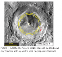
QUOTE (serpens @ Jun 14 2019, 12:33 AM)  Given the height of the Gale crater central peak the development of a peak ring is unlikely since this is predicated on the collapse of the central peak. Not necessarily, the peak ring can also be an uplift effect. QUOTE A MASSIVE CENTRAL PEAK AND A LOW PEAK RING IN GALE CRATER – IMPORTANT INFLUENCES ON THE FORMATION OF MT. SHARP. Gale’s central peak and peak ring were emplaced immediately after the impact, and influenced the subsequent history of deposition and erosion that formed Mt. Sharp (snip) Spray et al { Spray J. et al (2013) LPS XLIV, Abs. #2959.} suggested that a peak ring in Gale crater could have influenced the location Mt. Sharp’s lower segment by localizing the deposition of sediments. This effect could account for the fact that the northern, eastern, and western boundaries of Mt. Sharp correspond to a ~ 80 km diameter circle (Fig. 4). https://ntrs.nasa.gov/archive/nasa/casi.ntr...20150001905.pdf Also important - Gale crater's rim and floor tilt down towards the North. Assuming this is not due to post-impact subsidence, that suggests the breccia reservoir is also tiled, and the Northern edge of the reservoir is deeper than the southern edge. It seems that rain or surface water could flow into the central ring, so water in the sloped 80km diameter inner ring would have collected into a crescent-shaped lake along the Northern edge of the inner ring. That water would have percolated through the warm outer ring breccia, experience hydrothermal alterations, and then exited at roughly the location of the current Vera Rubin Ridge. Surface water from a large area enters Gale from the southwest and flows clockwise across the area between the inner and outer ring. This would seem to suggest that 2 different types of water 1-hydrothermal springs associated with the northern arc of the inner ring, and 2- surface water flowing across the crater floor from the west, would have mixed in roughly the location where we now find Vera Rubin Ridge. The early hydrothermal system could have created acidic mineral deposits along faults and along the inner crater ring. Those minerals could leech out and cement later lake sediments. Another interesting article on impact crater hydrothermal systems, this one specific to Gale Crater Gale Crater: Formation and post-impact hydrous environments https://www.sciencedirect.com/science/artic...1274?via%3Dihub
Attached thumbnail(s)
|
||
|
|
|
||
 ngunn Geomorphology of Gale Crater Sep 26 2012, 10:22 PM
 Don1 @Gerald: I recently came across another very inter... Aug 27 2016, 08:07 AM
 Gerald QUOTE (Don1 @ Aug 27 2016, 10:07 AM) In h... Aug 27 2016, 12:49 PM Don1 From the GSA meeting abstracts:
"LONG-LIVED ... Aug 27 2016, 08:35 AM serpens Re your comment on "TESTING A MECHANICAL MODE... Aug 27 2016, 11:50 AM Don1 @serpens....Yes, I was wondering about that when I... Aug 27 2016, 08:52 PM serpens The Watkins, Grotzinger and Avouac paper in no way... Aug 28 2016, 12:42 AM MarkG In reading this, please keep in mind the profound ... Aug 28 2016, 11:49 PM tty "The mention of "oxic conditions" i... Sep 1 2016, 06:57 PM serpens Probably photodissociation of CO2 and H2O. This r... Sep 1 2016, 11:28 PM tty Yes. The process has actually been rather extensiv... Sep 2 2016, 08:29 AM PDP8E Hematite? (aka Squyers' blueberries) Dec 25 2016, 05:19 PM Steve5304 QUOTE (PDP8E @ Dec 25 2016, 06:19 PM) Hem... Dec 28 2016, 04:00 AM HSchirmer QUOTE (Steve5304 @ Dec 28 2016, 05:00 AM)... Dec 28 2016, 06:29 PM Steve5304 QUOTE (HSchirmer @ Dec 28 2016, 07:29 PM)... Dec 28 2016, 07:20 PM serpens After the exhaustive work to identify the provenan... Dec 28 2016, 09:47 PM Steve5304 QUOTE (serpens @ Dec 28 2016, 10:47 PM) A... Dec 29 2016, 12:27 AM HSchirmer QUOTE (Steve5304 @ Dec 29 2016, 12:27 AM)... Dec 29 2016, 12:55 AM serpens We have to climb around another hundred metres of ... Dec 29 2016, 02:33 AM HSchirmer QUOTE We have to climb around another hundred metr... Dec 29 2016, 10:53 PM Julius Simply brilliant stuff! Dec 29 2016, 07:52 AM Greg Malone To add to the mix of ideas about dessicated mudcra... Dec 29 2016, 06:34 PM HSchirmer QUOTE (Greg Malone @ Dec 29 2016, 06:34 P... Jan 3 2017, 02:40 PM serpens Basically a closed system I expect. One needs to ... Dec 31 2016, 02:06 AM dburt QUOTE (serpens @ Dec 30 2016, 07:06 PM) .... Dec 31 2016, 04:24 AM HSchirmer QUOTE (serpens @ Dec 31 2016, 02:06 AM) B... Dec 31 2016, 02:33 PM HSchirmer QUOTE (serpens @ Dec 31 2016, 03:06 AM) B... Jan 2 2017, 01:49 PM Julius Sulphates on Earth require oxygen to form either b... Jan 12 2017, 09:41 PM serpens SAM has the capability to conduct isotopic analysi... Jan 13 2017, 11:14 PM dburt Julius, I agree with what Serpens said, but to try... Jan 14 2017, 12:02 AM Julius The consensus up to now seems to have been that su... Jun 7 2017, 02:41 AM Gerald My first thought about the silica enrichment has b... Jun 7 2017, 06:38 AM serpens Julius, I think that Curiosity will need to get up... Jun 7 2017, 08:40 AM serpens QUOTE (HSchirmer @ Nov 8 2018, 05:06 PM
...Given t... Nov 9 2018, 12:14 AM HSchirmer QUOTE (serpens @ Nov 9 2018, 01:14 AM) Th... Nov 9 2018, 12:57 AM serpens I suspect that this would represent the maximum fi... Nov 11 2018, 05:33 AM HSchirmer Theory - Gale Crater was a bay when the Arabia Oce... Nov 11 2018, 04:12 PM HSchirmer QUOTE I suspect that this would represent the maxi... Nov 11 2018, 05:27 PM serpens The basal/basalt misinterpretation was explained, ... Feb 4 2019, 05:53 AM atomoid As referenced in an article on sciencenews.org acc... Feb 5 2019, 10:04 PM serpens The hardness of the Jura and upper Pettegrove Poin... Feb 6 2019, 01:27 AM serpens Just in case anyone missed it, Emily provided an u... Feb 9 2019, 04:08 AM HSchirmer Curious if a new theory about the Pathfinder site ... Mar 17 2019, 03:22 PM serpens HSchirmer, could I perhaps suggest that you may li... Jun 7 2019, 06:33 AM HSchirmer Already received that admonition from a Mod.
Curi... Jun 9 2019, 10:14 PM serpens QUOTE (HSchirmer @ Jun 9 2019, 11:14 PM) ... Jun 10 2019, 12:35 AM jccwrt In addition, acidic waters rapidly neutralize in b... Jun 10 2019, 04:38 PM HSchirmer QUOTE (jccwrt @ Jun 10 2019, 05:38 PM) In... Jun 10 2019, 08:10 PM serpens There is no indication that the northern ocean int... Jun 11 2019, 01:55 AM HSchirmer QUOTE (serpens @ Jun 11 2019, 01:55 AM) (... Jun 11 2019, 04:51 AM serpens The proportional change in phyllosilicate and amor... Jun 12 2019, 02:47 AM jccwrt I'm not sure we can entirely discount a contri... Jun 12 2019, 05:13 AM HSchirmer QUOTE (jccwrt @ Jun 12 2019, 06:13 AM) An... Jun 12 2019, 09:16 PM ngunn In such well informed company I have nothing to ad... Jun 13 2019, 08:41 AM HSchirmer QUOTE (ngunn @ Jun 13 2019, 09:41 AM) (sn... Jun 13 2019, 02:15 PM HSchirmer Perhaps Gale crater was, for perhaps half-a-millio... Jun 13 2019, 06:18 PM HSchirmer QUOTE (serpens @ Jun 14 2019, 01:33 AM) (... Jun 16 2019, 11:18 PM HSchirmer Here's a thought- Ahuna Mons on Ceres seems t... Jun 15 2019, 02:54 AM serpens On Earth it would be a reasonably simple matter to... Jun 16 2019, 04:31 AM serpens I don't think that a pseudo Langmuir circulat... Jun 18 2019, 01:30 AM HSchirmer QUOTE (serpens @ Jun 18 2019, 02:30 AM) I... Jun 18 2019, 04:33 PM HSchirmer Let me take a step back-
I've been thinking a... Jun 18 2019, 07:45 PM serpens Immediately following the Gale impact there would ... Jun 23 2019, 03:08 AM HSchirmer QUOTE (serpens @ Jun 23 2019, 04:08 AM) (... Jun 23 2019, 09:13 AM serpens The introduction of the paper you link indicates t... Jun 24 2019, 11:50 PM ngunn Maybe it's worth noting that we see absolutely... Jun 25 2019, 08:24 AM serpens In their supplementary materials for their paper ... Jun 25 2019, 01:52 PM stevesliva QUOTE (ngunn @ Jun 25 2019, 04:24 AM) May... Jun 25 2019, 03:05 PM serpens Some interesting and thought provoking abstracts f... Jul 4 2019, 11:41 PM HSchirmer QUOTE (serpens @ Jul 5 2019, 12:41 AM) So... Jul 8 2019, 01:47 AM jccwrt I'd expect most of the new science results wer... Jul 8 2019, 03:01 AM serpens Exactly. Jul 8 2019, 04:03 AM PaulH51 This open source paper appears to address some of ... May 17 2020, 10:45 AM serpens Thanks for that link. The conclusion that "t... May 17 2020, 11:25 PM PaulH51 Curiosity Rover Finds Clues to Chilly Ancient Mars... May 20 2020, 01:48 AM serpens I don't feel there is any contradiction with t... May 20 2020, 01:08 PM serpens An interesting abstract from LPSC 2021 which inclu... Mar 1 2021, 04:35 AM HSchirmer QUOTE (serpens @ Mar 1 2021, 04:35 AM) An... Mar 1 2021, 05:05 PM climber Not sure its the right section
From lake to rive... Sep 19 2022, 10:43 AM serpens Another possible indication of a northern ocean wi... Oct 28 2022, 05:29 AM Gladstoner Trying to make sense of the geologic context of th... Nov 17 2022, 10:29 PM Gladstoner Wider map view:
Nov 17 2022, 10:31 PM Gladstoner Possible northward extension of the Marker horizon... Nov 18 2022, 10:10 PM
Gerald QUOTE (Don1 @ Aug 27 2016, 10:07 AM) In h... Aug 27 2016, 12:49 PM Don1 From the GSA meeting abstracts:
"LONG-LIVED ... Aug 27 2016, 08:35 AM serpens Re your comment on "TESTING A MECHANICAL MODE... Aug 27 2016, 11:50 AM Don1 @serpens....Yes, I was wondering about that when I... Aug 27 2016, 08:52 PM serpens The Watkins, Grotzinger and Avouac paper in no way... Aug 28 2016, 12:42 AM MarkG In reading this, please keep in mind the profound ... Aug 28 2016, 11:49 PM tty "The mention of "oxic conditions" i... Sep 1 2016, 06:57 PM serpens Probably photodissociation of CO2 and H2O. This r... Sep 1 2016, 11:28 PM tty Yes. The process has actually been rather extensiv... Sep 2 2016, 08:29 AM PDP8E Hematite? (aka Squyers' blueberries) Dec 25 2016, 05:19 PM Steve5304 QUOTE (PDP8E @ Dec 25 2016, 06:19 PM) Hem... Dec 28 2016, 04:00 AM HSchirmer QUOTE (Steve5304 @ Dec 28 2016, 05:00 AM)... Dec 28 2016, 06:29 PM Steve5304 QUOTE (HSchirmer @ Dec 28 2016, 07:29 PM)... Dec 28 2016, 07:20 PM serpens After the exhaustive work to identify the provenan... Dec 28 2016, 09:47 PM Steve5304 QUOTE (serpens @ Dec 28 2016, 10:47 PM) A... Dec 29 2016, 12:27 AM HSchirmer QUOTE (Steve5304 @ Dec 29 2016, 12:27 AM)... Dec 29 2016, 12:55 AM serpens We have to climb around another hundred metres of ... Dec 29 2016, 02:33 AM HSchirmer QUOTE We have to climb around another hundred metr... Dec 29 2016, 10:53 PM Julius Simply brilliant stuff! Dec 29 2016, 07:52 AM Greg Malone To add to the mix of ideas about dessicated mudcra... Dec 29 2016, 06:34 PM HSchirmer QUOTE (Greg Malone @ Dec 29 2016, 06:34 P... Jan 3 2017, 02:40 PM serpens Basically a closed system I expect. One needs to ... Dec 31 2016, 02:06 AM dburt QUOTE (serpens @ Dec 30 2016, 07:06 PM) .... Dec 31 2016, 04:24 AM HSchirmer QUOTE (serpens @ Dec 31 2016, 02:06 AM) B... Dec 31 2016, 02:33 PM HSchirmer QUOTE (serpens @ Dec 31 2016, 03:06 AM) B... Jan 2 2017, 01:49 PM Julius Sulphates on Earth require oxygen to form either b... Jan 12 2017, 09:41 PM serpens SAM has the capability to conduct isotopic analysi... Jan 13 2017, 11:14 PM dburt Julius, I agree with what Serpens said, but to try... Jan 14 2017, 12:02 AM Julius The consensus up to now seems to have been that su... Jun 7 2017, 02:41 AM Gerald My first thought about the silica enrichment has b... Jun 7 2017, 06:38 AM serpens Julius, I think that Curiosity will need to get up... Jun 7 2017, 08:40 AM serpens QUOTE (HSchirmer @ Nov 8 2018, 05:06 PM
...Given t... Nov 9 2018, 12:14 AM HSchirmer QUOTE (serpens @ Nov 9 2018, 01:14 AM) Th... Nov 9 2018, 12:57 AM serpens I suspect that this would represent the maximum fi... Nov 11 2018, 05:33 AM HSchirmer Theory - Gale Crater was a bay when the Arabia Oce... Nov 11 2018, 04:12 PM HSchirmer QUOTE I suspect that this would represent the maxi... Nov 11 2018, 05:27 PM serpens The basal/basalt misinterpretation was explained, ... Feb 4 2019, 05:53 AM atomoid As referenced in an article on sciencenews.org acc... Feb 5 2019, 10:04 PM serpens The hardness of the Jura and upper Pettegrove Poin... Feb 6 2019, 01:27 AM serpens Just in case anyone missed it, Emily provided an u... Feb 9 2019, 04:08 AM HSchirmer Curious if a new theory about the Pathfinder site ... Mar 17 2019, 03:22 PM serpens HSchirmer, could I perhaps suggest that you may li... Jun 7 2019, 06:33 AM HSchirmer Already received that admonition from a Mod.
Curi... Jun 9 2019, 10:14 PM serpens QUOTE (HSchirmer @ Jun 9 2019, 11:14 PM) ... Jun 10 2019, 12:35 AM jccwrt In addition, acidic waters rapidly neutralize in b... Jun 10 2019, 04:38 PM HSchirmer QUOTE (jccwrt @ Jun 10 2019, 05:38 PM) In... Jun 10 2019, 08:10 PM serpens There is no indication that the northern ocean int... Jun 11 2019, 01:55 AM HSchirmer QUOTE (serpens @ Jun 11 2019, 01:55 AM) (... Jun 11 2019, 04:51 AM serpens The proportional change in phyllosilicate and amor... Jun 12 2019, 02:47 AM jccwrt I'm not sure we can entirely discount a contri... Jun 12 2019, 05:13 AM HSchirmer QUOTE (jccwrt @ Jun 12 2019, 06:13 AM) An... Jun 12 2019, 09:16 PM ngunn In such well informed company I have nothing to ad... Jun 13 2019, 08:41 AM HSchirmer QUOTE (ngunn @ Jun 13 2019, 09:41 AM) (sn... Jun 13 2019, 02:15 PM HSchirmer Perhaps Gale crater was, for perhaps half-a-millio... Jun 13 2019, 06:18 PM HSchirmer QUOTE (serpens @ Jun 14 2019, 01:33 AM) (... Jun 16 2019, 11:18 PM HSchirmer Here's a thought- Ahuna Mons on Ceres seems t... Jun 15 2019, 02:54 AM serpens On Earth it would be a reasonably simple matter to... Jun 16 2019, 04:31 AM serpens I don't think that a pseudo Langmuir circulat... Jun 18 2019, 01:30 AM HSchirmer QUOTE (serpens @ Jun 18 2019, 02:30 AM) I... Jun 18 2019, 04:33 PM HSchirmer Let me take a step back-
I've been thinking a... Jun 18 2019, 07:45 PM serpens Immediately following the Gale impact there would ... Jun 23 2019, 03:08 AM HSchirmer QUOTE (serpens @ Jun 23 2019, 04:08 AM) (... Jun 23 2019, 09:13 AM serpens The introduction of the paper you link indicates t... Jun 24 2019, 11:50 PM ngunn Maybe it's worth noting that we see absolutely... Jun 25 2019, 08:24 AM serpens In their supplementary materials for their paper ... Jun 25 2019, 01:52 PM stevesliva QUOTE (ngunn @ Jun 25 2019, 04:24 AM) May... Jun 25 2019, 03:05 PM serpens Some interesting and thought provoking abstracts f... Jul 4 2019, 11:41 PM HSchirmer QUOTE (serpens @ Jul 5 2019, 12:41 AM) So... Jul 8 2019, 01:47 AM jccwrt I'd expect most of the new science results wer... Jul 8 2019, 03:01 AM serpens Exactly. Jul 8 2019, 04:03 AM PaulH51 This open source paper appears to address some of ... May 17 2020, 10:45 AM serpens Thanks for that link. The conclusion that "t... May 17 2020, 11:25 PM PaulH51 Curiosity Rover Finds Clues to Chilly Ancient Mars... May 20 2020, 01:48 AM serpens I don't feel there is any contradiction with t... May 20 2020, 01:08 PM serpens An interesting abstract from LPSC 2021 which inclu... Mar 1 2021, 04:35 AM HSchirmer QUOTE (serpens @ Mar 1 2021, 04:35 AM) An... Mar 1 2021, 05:05 PM climber Not sure its the right section
From lake to rive... Sep 19 2022, 10:43 AM serpens Another possible indication of a northern ocean wi... Oct 28 2022, 05:29 AM Gladstoner Trying to make sense of the geologic context of th... Nov 17 2022, 10:29 PM Gladstoner Wider map view:
Nov 17 2022, 10:31 PM Gladstoner Possible northward extension of the Marker horizon... Nov 18 2022, 10:10 PM |

|
Lo-Fi Version | Time is now: 5th June 2024 - 07:47 AM |
|
RULES AND GUIDELINES Please read the Forum Rules and Guidelines before posting. IMAGE COPYRIGHT |
OPINIONS AND MODERATION Opinions expressed on UnmannedSpaceflight.com are those of the individual posters and do not necessarily reflect the opinions of UnmannedSpaceflight.com or The Planetary Society. The all-volunteer UnmannedSpaceflight.com moderation team is wholly independent of The Planetary Society. The Planetary Society has no influence over decisions made by the UnmannedSpaceflight.com moderators. |
SUPPORT THE FORUM Unmannedspaceflight.com is funded by the Planetary Society. Please consider supporting our work and many other projects by donating to the Society or becoming a member. |
|