Yutu-2 route map |

Yutu-2 route map |
 Jan 3 2019, 09:04 PM Jan 3 2019, 09:04 PM
Post
#1
|
||
|
Solar System Cartographer  Group: Members Posts: 10193 Joined: 5-April 05 From: Canada Member No.: 227 |
I am setting this up to record activities of Yutu 2, but it looks as if this will be difficult unless we start to see more data releases. As soon as LRO images the lander (and the image is released) I can put a rough background on the map. When descent images of the actual site are released thay can be improved on. Until then this will be very simple.
Let me know if you see any signs of maps or feature names, including in the background of a TV broadcast or on a forum. Meanwhile, a first contribution. So simple it's almost not necessary, but you have to start somewhere. So rough I am not including a scale yet. I welcome anyone else's maps as well. Phil
-------------------- ... because the Solar System ain't gonna map itself.
Also to be found posting similar content on https://mastodon.social/@PhilStooke Maps for download (free PD: https://upload.wikimedia.org/wikipedia/comm...Cartography.pdf NOTE: everything created by me which I post on UMSF is considered to be in the public domain (NOT CC, public domain) |
|
 |
 
|
|
 |
|
Jun 26 2019, 07:19 PM
Post
#2
|
||||
|
Solar System Cartographer Group: Members Posts: 10193 Joined: 5-April 05 From: Canada Member No.: 227 |
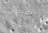
Pictures from lunar day 6, released at the start of lunar day 7, let me revise the route map. I don't really know that those images cover all the day 6 tracks or that I have joined them correctly, but this is what i have at the moment.
3 maps this time. The first is the updated version of the previous map. The other two are more detailed maps adding labels from a recent Chinese map noted in the other thread. I have changed symbols and added a legend to match previous work on Chang'e 3's route map. Phil
-------------------- ... because the Solar System ain't gonna map itself.
Also to be found posting similar content on https://mastodon.social/@PhilStooke Maps for download (free PD: https://upload.wikimedia.org/wikipedia/comm...Cartography.pdf NOTE: everything created by me which I post on UMSF is considered to be in the public domain (NOT CC, public domain) |
|||
|
|
|
|||
 Phil Stooke Yutu-2 route map Jan 3 2019, 09:04 PM
 Phil Stooke No new information really, except the total distan... Feb 18 2019, 12:12 AM kenny So it has now exceeded the drive distance of Yutu-... Feb 18 2019, 07:34 AM SpaceListener A recent picture from LRO on Chang'e-4' la... Feb 18 2019, 03:33 PM Phil Stooke Yes, Kenny, it has exceeded the first Yutu's d... Feb 18 2019, 06:33 PM John Moore Phil...to see rover tracks: presuming LRO will low... Feb 18 2019, 09:50 PM Phil Stooke No, don't look for any change in the orbit, th... Feb 19 2019, 02:14 AM Phil Stooke Thanks, John.
Here is an update based on a map se... Feb 28 2019, 12:43 AM elakdawalla Just a reminder that the route map threads are str... Mar 4 2019, 04:11 PM Phil Stooke A very approximate location for our current positi... Mar 4 2019, 08:06 PM Phil Stooke Another iteration of the map. I wanted to get the... Mar 13 2019, 03:47 AM Phil Stooke A map update using the new LRO image to get an exa... Mar 22 2019, 03:34 AM Phil Stooke Andrew Jones tweeted a map here:
https://twitter.... Mar 25 2019, 05:58 PM Phil Stooke No real news but I decided to show an estimate for... Apr 27 2019, 12:14 PM Phil Stooke This is a slightly tentative route map up to day 5... May 17 2019, 05:09 PM Phil Stooke China isn't exactly making my life easy at the... Jun 10 2019, 07:00 PM Phil Stooke This is a preliminary update based on the reprojec... Jul 9 2019, 08:30 PM Phil Stooke Andrew Jones tweeted a total distance of 271 m aft... Aug 7 2019, 05:30 PM Phil Stooke Took a while to get this together from the latest ... Sep 18 2019, 08:59 PM Phil Stooke A new paper in Earth and Planetary Science Letters... Oct 2 2019, 10:06 PM Phil Stooke This is my estimate of the location after the 11th... Nov 5 2019, 09:29 PM Phil Stooke A new map update using the newest Day 12 images. ... Dec 13 2019, 02:11 AM Phil Stooke OK, new data! From maps and a video of the tr... Jan 4 2020, 03:43 AM Phil Stooke This is my current route map, updated using the ne... Jan 16 2020, 08:07 PM Phil Stooke I am incorporating those observation numbers (or w... Feb 7 2020, 08:52 PM Phil Stooke Here's a special map of the area around the im... Feb 8 2020, 06:21 AM Phil Stooke Here is an updated version of the map. Still no i... Feb 15 2020, 09:42 PM Phil Stooke Here's a map update to day 15, which just ende... Mar 5 2020, 06:04 PM Phil Stooke A very tentative update to the 16th lunar night, w... Apr 8 2020, 09:37 PM Phil Stooke This is an updated version of the map shown a few ... Apr 8 2020, 11:42 PM Phil Stooke Another close-up map: this is the rock analyzed by... Apr 12 2020, 07:09 PM Phil Stooke I have updated the route map based on a map in the... Apr 15 2020, 05:35 PM Phil Stooke This map updates us to the end of lunar day 17. U... May 1 2020, 08:12 PM Paolo I don't know how useful it can be, but this pa... May 9 2020, 09:11 AM Phil Stooke Thanks, Paolo. This is interesting but doesn... May 31 2020, 09:17 PM Phil Stooke A tentative update to the end of the 19th day. No... Jun 28 2020, 03:58 PM Phil Stooke Another tentative update for the end of day 20. I... Jul 30 2020, 02:38 AM Phil Stooke A new drive diary was published here:
https://www... Aug 2 2020, 07:26 AM
Phil Stooke No new information really, except the total distan... Feb 18 2019, 12:12 AM kenny So it has now exceeded the drive distance of Yutu-... Feb 18 2019, 07:34 AM SpaceListener A recent picture from LRO on Chang'e-4' la... Feb 18 2019, 03:33 PM Phil Stooke Yes, Kenny, it has exceeded the first Yutu's d... Feb 18 2019, 06:33 PM John Moore Phil...to see rover tracks: presuming LRO will low... Feb 18 2019, 09:50 PM Phil Stooke No, don't look for any change in the orbit, th... Feb 19 2019, 02:14 AM Phil Stooke Thanks, John.
Here is an update based on a map se... Feb 28 2019, 12:43 AM elakdawalla Just a reminder that the route map threads are str... Mar 4 2019, 04:11 PM Phil Stooke A very approximate location for our current positi... Mar 4 2019, 08:06 PM Phil Stooke Another iteration of the map. I wanted to get the... Mar 13 2019, 03:47 AM Phil Stooke A map update using the new LRO image to get an exa... Mar 22 2019, 03:34 AM Phil Stooke Andrew Jones tweeted a map here:
https://twitter.... Mar 25 2019, 05:58 PM Phil Stooke No real news but I decided to show an estimate for... Apr 27 2019, 12:14 PM Phil Stooke This is a slightly tentative route map up to day 5... May 17 2019, 05:09 PM Phil Stooke China isn't exactly making my life easy at the... Jun 10 2019, 07:00 PM Phil Stooke This is a preliminary update based on the reprojec... Jul 9 2019, 08:30 PM Phil Stooke Andrew Jones tweeted a total distance of 271 m aft... Aug 7 2019, 05:30 PM Phil Stooke Took a while to get this together from the latest ... Sep 18 2019, 08:59 PM Phil Stooke A new paper in Earth and Planetary Science Letters... Oct 2 2019, 10:06 PM Phil Stooke This is my estimate of the location after the 11th... Nov 5 2019, 09:29 PM Phil Stooke A new map update using the newest Day 12 images. ... Dec 13 2019, 02:11 AM Phil Stooke OK, new data! From maps and a video of the tr... Jan 4 2020, 03:43 AM Phil Stooke This is my current route map, updated using the ne... Jan 16 2020, 08:07 PM Phil Stooke I am incorporating those observation numbers (or w... Feb 7 2020, 08:52 PM Phil Stooke Here's a special map of the area around the im... Feb 8 2020, 06:21 AM Phil Stooke Here is an updated version of the map. Still no i... Feb 15 2020, 09:42 PM Phil Stooke Here's a map update to day 15, which just ende... Mar 5 2020, 06:04 PM Phil Stooke A very tentative update to the 16th lunar night, w... Apr 8 2020, 09:37 PM Phil Stooke This is an updated version of the map shown a few ... Apr 8 2020, 11:42 PM Phil Stooke Another close-up map: this is the rock analyzed by... Apr 12 2020, 07:09 PM Phil Stooke I have updated the route map based on a map in the... Apr 15 2020, 05:35 PM Phil Stooke This map updates us to the end of lunar day 17. U... May 1 2020, 08:12 PM Paolo I don't know how useful it can be, but this pa... May 9 2020, 09:11 AM Phil Stooke Thanks, Paolo. This is interesting but doesn... May 31 2020, 09:17 PM Phil Stooke A tentative update to the end of the 19th day. No... Jun 28 2020, 03:58 PM Phil Stooke Another tentative update for the end of day 20. I... Jul 30 2020, 02:38 AM Phil Stooke A new drive diary was published here:
https://www... Aug 2 2020, 07:26 AM
 Antdoghalo Hey Phil, could you please upload the map as 2 sep... Aug 13 2020, 03:08 AM Phil Stooke OK! Send me a reminder when you need it if I ... Aug 13 2020, 05:11 PM Antdoghalo Many Thanks! Aug 13 2020, 05:27 PM Phil Stooke This is a bit of an experiment. I am plotting rep... Aug 13 2020, 08:35 PM Phil Stooke Update to the end of day 21. The last 2 sections ... Aug 28 2020, 09:16 PM Phil Stooke Day 22 update. The last points on the previous ma... Oct 4 2020, 07:53 PM Phil Stooke This is a quick update for lunar day 23. The exac... Oct 24 2020, 03:27 AM Phil Stooke This is still an approximation for the 23rd day dr... Nov 4 2020, 10:01 PM Phil Stooke No drive diary or other information yet so I still... Nov 30 2020, 09:24 PM Phil Stooke Here is a map up to the end of day 25 (with the la... Dec 22 2020, 07:01 PM Phil Stooke A new drive diary tweeted about by Andrew Jones gi... Jan 3 2021, 08:07 AM Phil Stooke Two maps for the end of the 26th day. The details... Feb 3 2021, 07:52 AM Phil Stooke This is a corrected version of the map for the end... Feb 20 2021, 08:16 AM kymani76 Yutu 2 drive map updated to lunar day 27. The rove... Mar 8 2021, 04:14 PM kymani76
If I understand above mentioned article correctl... Mar 8 2021, 04:47 PM Phil Stooke They are driving in that direction during the 28th... Mar 8 2021, 09:16 PM John Moore The nomenclature names confused me, too, Phil.
As... Mar 8 2021, 11:19 PM Phil Stooke All our Mars missions give informal names to featu... Mar 8 2021, 11:41 PM John Moore Well, at least, the IAU gave official refence to P... Mar 9 2021, 12:00 AM Phil Stooke My feeling is that informal names are just as sign... Mar 9 2021, 12:51 AM John Moore Yeah, see your point, Phil...you're right.
Jo... Mar 9 2021, 04:20 AM Phil Stooke This map takes us up to the end of lunar day 28. ... Apr 8 2021, 03:20 AM Phil Stooke This is a very rough map for lunar day 29. Up to ... Apr 27 2021, 06:07 AM Phil Stooke A drive diary did show up here:
https://www.163.co... May 9 2021, 02:14 AM Huguet The PCAM stereo clusters of images from Yutu-2 all... May 12 2021, 01:01 PM Phil Stooke The first big data release covered that period you... May 12 2021, 11:39 PM Huguet The most recents there are from Apr 2020. On Scien... May 13 2021, 10:53 AM Phil Stooke Very little news about Yutu 2 except a statement a... Jul 8 2021, 06:37 AM Phil Stooke Not much news lately except distances driven. Jus... Sep 5 2021, 03:21 AM Phil Stooke Finally - an update on Chang'e 4 and Yutu 2. ... Sep 29 2021, 06:52 PM Phil Stooke Here is a full route map for Yutu 2 combining the ... Sep 30 2021, 12:44 AM Phil Stooke An update at this site:
https://mp.weixin.qq.com/... Oct 26 2021, 08:04 PM Phil Stooke You might enjoy this map showing the landing regio... Nov 4 2021, 01:59 AM Phil Stooke This is an update for lunar day 36. The drive dur... Dec 3 2021, 08:19 AM Phil Stooke And the full map including the last few months.
P... Dec 3 2021, 08:29 AM marsbug Thanks for keeping the updates going Phil, it... Dec 5 2021, 10:29 PM Phil Stooke A Chinese map up to the 37th day has been released... Jan 4 2022, 04:25 AM kymani76
My version in addition to Phil's. Jan 14 2022, 11:51 PM Phil Stooke A very small map shown on sohu.com ( https://www.... Jan 16 2022, 08:38 AM Phil Stooke We are well into the 39th lunar day today so here ... Feb 4 2022, 03:38 AM Phil Stooke Using images from the drive diary I have estimated... Feb 27 2022, 12:06 AM Phil Stooke Good news on the map front. The LROC team have up... Feb 27 2022, 12:53 AM Phil Stooke The latest news discussed in the other thread lead... Apr 15 2022, 02:54 AM Phil Stooke And the full map to go with it.
Phil
Apr 15 2022, 03:00 AM Phil Stooke Here is a corrected map for the end of lunar day 4... Apr 30 2022, 07:03 AM Phil Stooke This map for the end of lunar day 42 is updated us... Jun 17 2022, 07:46 PM Phil Stooke This context map shows the traverse as of day 42 a... Jun 17 2022, 07:58 PM Phil Stooke Another context map. A description of how it was ... Jun 18 2022, 03:11 AM Phil Stooke Here is the full map up to day 44. It leaves me u... Jul 25 2022, 03:25 AM Phil Stooke The first part of a map update to the end of lunar... Jan 3 2023, 10:06 PM Thorsten Denk QUOTE (Phil Stooke @ Jan 3 2023, 11:06 PM... Jan 6 2023, 11:10 AM Phil Stooke Here are two sections of my Yutu 2 route map at th... Jan 4 2023, 04:13 AM Phil Stooke And my update of the full map... which needs an ex... Jan 4 2023, 05:01 AM Phil Stooke Good point, Thorsten!
A new map at last! ... Jul 12 2023, 06:11 AM Phil Stooke Andrew Jones has tweeted ( I can't say 'Xe... Sep 5 2023, 07:19 PM marsbug As ever: Thanks for doing this Phil! Sep 6 2023, 01:35 AM Phil Stooke You're welcome!
Here is the full traverse... Sep 12 2023, 06:54 AM Phil Stooke The same path shown on a topo map - green is low, ... Sep 19 2023, 06:50 AM Phil Stooke https://m.weibo.cn/p/index?extparam=%E6%9C%...a0d2... Sep 27 2023, 08:09 PM Phil Stooke Andrew Jones tweeted a map up to the present date ... Sep 30 2023, 02:33 AM Phil Stooke My full map up to the end of day 59.
Phil
Oct 16 2023, 06:10 PM Phil Stooke My estimate of the new position based on that new ... Mar 4 2024, 09:28 PM
Antdoghalo Hey Phil, could you please upload the map as 2 sep... Aug 13 2020, 03:08 AM Phil Stooke OK! Send me a reminder when you need it if I ... Aug 13 2020, 05:11 PM Antdoghalo Many Thanks! Aug 13 2020, 05:27 PM Phil Stooke This is a bit of an experiment. I am plotting rep... Aug 13 2020, 08:35 PM Phil Stooke Update to the end of day 21. The last 2 sections ... Aug 28 2020, 09:16 PM Phil Stooke Day 22 update. The last points on the previous ma... Oct 4 2020, 07:53 PM Phil Stooke This is a quick update for lunar day 23. The exac... Oct 24 2020, 03:27 AM Phil Stooke This is still an approximation for the 23rd day dr... Nov 4 2020, 10:01 PM Phil Stooke No drive diary or other information yet so I still... Nov 30 2020, 09:24 PM Phil Stooke Here is a map up to the end of day 25 (with the la... Dec 22 2020, 07:01 PM Phil Stooke A new drive diary tweeted about by Andrew Jones gi... Jan 3 2021, 08:07 AM Phil Stooke Two maps for the end of the 26th day. The details... Feb 3 2021, 07:52 AM Phil Stooke This is a corrected version of the map for the end... Feb 20 2021, 08:16 AM kymani76 Yutu 2 drive map updated to lunar day 27. The rove... Mar 8 2021, 04:14 PM kymani76
If I understand above mentioned article correctl... Mar 8 2021, 04:47 PM Phil Stooke They are driving in that direction during the 28th... Mar 8 2021, 09:16 PM John Moore The nomenclature names confused me, too, Phil.
As... Mar 8 2021, 11:19 PM Phil Stooke All our Mars missions give informal names to featu... Mar 8 2021, 11:41 PM John Moore Well, at least, the IAU gave official refence to P... Mar 9 2021, 12:00 AM Phil Stooke My feeling is that informal names are just as sign... Mar 9 2021, 12:51 AM John Moore Yeah, see your point, Phil...you're right.
Jo... Mar 9 2021, 04:20 AM Phil Stooke This map takes us up to the end of lunar day 28. ... Apr 8 2021, 03:20 AM Phil Stooke This is a very rough map for lunar day 29. Up to ... Apr 27 2021, 06:07 AM Phil Stooke A drive diary did show up here:
https://www.163.co... May 9 2021, 02:14 AM Huguet The PCAM stereo clusters of images from Yutu-2 all... May 12 2021, 01:01 PM Phil Stooke The first big data release covered that period you... May 12 2021, 11:39 PM Huguet The most recents there are from Apr 2020. On Scien... May 13 2021, 10:53 AM Phil Stooke Very little news about Yutu 2 except a statement a... Jul 8 2021, 06:37 AM Phil Stooke Not much news lately except distances driven. Jus... Sep 5 2021, 03:21 AM Phil Stooke Finally - an update on Chang'e 4 and Yutu 2. ... Sep 29 2021, 06:52 PM Phil Stooke Here is a full route map for Yutu 2 combining the ... Sep 30 2021, 12:44 AM Phil Stooke An update at this site:
https://mp.weixin.qq.com/... Oct 26 2021, 08:04 PM Phil Stooke You might enjoy this map showing the landing regio... Nov 4 2021, 01:59 AM Phil Stooke This is an update for lunar day 36. The drive dur... Dec 3 2021, 08:19 AM Phil Stooke And the full map including the last few months.
P... Dec 3 2021, 08:29 AM marsbug Thanks for keeping the updates going Phil, it... Dec 5 2021, 10:29 PM Phil Stooke A Chinese map up to the 37th day has been released... Jan 4 2022, 04:25 AM kymani76
My version in addition to Phil's. Jan 14 2022, 11:51 PM Phil Stooke A very small map shown on sohu.com ( https://www.... Jan 16 2022, 08:38 AM Phil Stooke We are well into the 39th lunar day today so here ... Feb 4 2022, 03:38 AM Phil Stooke Using images from the drive diary I have estimated... Feb 27 2022, 12:06 AM Phil Stooke Good news on the map front. The LROC team have up... Feb 27 2022, 12:53 AM Phil Stooke The latest news discussed in the other thread lead... Apr 15 2022, 02:54 AM Phil Stooke And the full map to go with it.
Phil
Apr 15 2022, 03:00 AM Phil Stooke Here is a corrected map for the end of lunar day 4... Apr 30 2022, 07:03 AM Phil Stooke This map for the end of lunar day 42 is updated us... Jun 17 2022, 07:46 PM Phil Stooke This context map shows the traverse as of day 42 a... Jun 17 2022, 07:58 PM Phil Stooke Another context map. A description of how it was ... Jun 18 2022, 03:11 AM Phil Stooke Here is the full map up to day 44. It leaves me u... Jul 25 2022, 03:25 AM Phil Stooke The first part of a map update to the end of lunar... Jan 3 2023, 10:06 PM Thorsten Denk QUOTE (Phil Stooke @ Jan 3 2023, 11:06 PM... Jan 6 2023, 11:10 AM Phil Stooke Here are two sections of my Yutu 2 route map at th... Jan 4 2023, 04:13 AM Phil Stooke And my update of the full map... which needs an ex... Jan 4 2023, 05:01 AM Phil Stooke Good point, Thorsten!
A new map at last! ... Jul 12 2023, 06:11 AM Phil Stooke Andrew Jones has tweeted ( I can't say 'Xe... Sep 5 2023, 07:19 PM marsbug As ever: Thanks for doing this Phil! Sep 6 2023, 01:35 AM Phil Stooke You're welcome!
Here is the full traverse... Sep 12 2023, 06:54 AM Phil Stooke The same path shown on a topo map - green is low, ... Sep 19 2023, 06:50 AM Phil Stooke https://m.weibo.cn/p/index?extparam=%E6%9C%...a0d2... Sep 27 2023, 08:09 PM Phil Stooke Andrew Jones tweeted a map up to the present date ... Sep 30 2023, 02:33 AM Phil Stooke My full map up to the end of day 59.
Phil
Oct 16 2023, 06:10 PM Phil Stooke My estimate of the new position based on that new ... Mar 4 2024, 09:28 PM |

|
Lo-Fi Version | Time is now: 16th June 2024 - 04:32 PM |
|
RULES AND GUIDELINES Please read the Forum Rules and Guidelines before posting. IMAGE COPYRIGHT |
OPINIONS AND MODERATION Opinions expressed on UnmannedSpaceflight.com are those of the individual posters and do not necessarily reflect the opinions of UnmannedSpaceflight.com or The Planetary Society. The all-volunteer UnmannedSpaceflight.com moderation team is wholly independent of The Planetary Society. The Planetary Society has no influence over decisions made by the UnmannedSpaceflight.com moderators. |
SUPPORT THE FORUM Unmannedspaceflight.com is funded by the Planetary Society. Please consider supporting our work and many other projects by donating to the Society or becoming a member. |
|