InSight Surface Operations, 26 Nov 2018- 21 Dec 2022 |

InSight Surface Operations, 26 Nov 2018- 21 Dec 2022 |
 Nov 26 2018, 08:20 PM Nov 26 2018, 08:20 PM
Post
#801
|
|
|
Merciless Robot  Group: Admin Posts: 8785 Joined: 8-December 05 From: Los Angeles Member No.: 602 |
Congratulations to the InSight team on a successful landing! We'll discuss the remainder of the mission here.

-------------------- A few will take this knowledge and use this power of a dream realized as a force for change, an impetus for further discovery to make less ancient dreams real.
|
 |
 
|
 |
|
Jan 30 2020, 12:02 AM
Post
#802
|
||||
|
Member Group: Members Posts: 866 Joined: 15-March 05 From: Santa Cruz, CA Member No.: 196 |
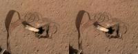
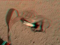
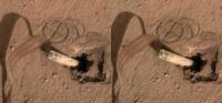
Here is one set of the sol417 stereo pairs, from the left in crosseye/anaglyph/parallel renderings:
"the alien instrument descended as dusts of ages fell away revealing a sort of portal, as if a long buried Cenote emerging from the deep to accept the sacrifice" |
|||
|
|
|
|||
|
Jan 30 2020, 07:08 PM
Post
#803
|
|
 Member Group: Members Posts: 684 Joined: 24-July 15 Member No.: 7619 |
QUOTE (atomoid @ Jan 30 2020, 12:02 AM)  Here is one set of the parallel renderings: Oh WOW. That is a HUGE amount of missing volume! Can that ALL be from compaction? I'm starting to think there is a void UNDER the duricrust, and the mole punched a small hole through which is allowing the soil to drop down into a void? |
|
|
|
|
Jan 30 2020, 08:46 PM
Post
#804
|
|
|
Senior Member Group: Members Posts: 3516 Joined: 4-November 05 From: North Wales Member No.: 542 |
QUOTE (HSchirmer @ Jan 30 2020, 08:08 PM) Can that ALL be from compaction? It was partly wondering about this that prompted me to ask the question about densities a few posts back. Apart from the visible void there is the volume now occupied by the probe itself. If the regolith here is indeed very porous and lightly packed that would initially have helped the mole to sink. Maybe the hammering causes the stuff to collapse and there is now a much denser sand 'puddle' at the bottom of the hole. |
|
|
|
|
Jan 31 2020, 11:13 AM
Post
#805
|
|
 Senior Member Group: Members Posts: 2530 Joined: 20-April 05 Member No.: 321 |
The presence of duricrust implies the previous presence of saline water from which the water departed. To some extent, this compaction must be showing us how much water there once was.
|
|
|
|
|
Feb 2 2020, 10:51 AM
Post
#806
|
|
|
Senior Member Group: Members Posts: 1057 Joined: 17-February 09 Member No.: 4605 |
QUOTE (JRehling @ Jan 31 2020, 11:13 AM) The presence of duricrust implies the previous presence of saline water from which the water departed. To some extent, this compaction must be showing us how much water there once was. The scenario seems to be that the mole encountered a duricrust layer beneath the reasonably loose regolith. When the mole encountered the cemented layer there was insufficient friction against the barrel from the surface deposits to let it penetrate and the mole effectively bounced around compacting the (comparatively) loose material. The friction applied by the scoop permitted the mole to begin to penetrate the duricrust but the effect diminished with depth and the mole bounced back, possibly with loose material sifting down to progressively refill the hole. There is no way to tell how deep the duricrust layer is but it could be measured in metres, representing the surface a long time ago. |
|
|
|
|
Feb 3 2020, 05:34 AM
Post
#807
|
|
|
Senior Member Group: Members Posts: 2530 Joined: 20-April 05 Member No.: 321 |
QUOTE (serpens @ Feb 2 2020, 03:51 AM) The scenario seems to be that the mole encountered a duricrust layer beneath the reasonably loose regolith. Correct me if I'm reading this wrong, but that seems to me to be the opposite (vertically speaking) of what the team blog said on December 23: "The most convincing (at least to me) explanation for the backing out of the mole assumes that the duricrust is underlain by cohesionless sand." And further, " motion of the mole provides an estimate for the thickness of the duricrust of about 20cm." You speak of a duricrust layer under loose regolith, but they speak of loose (cohesionless) material below the duricrust. And you speak of unknown thickness perhaps meters and they speak of about 20 cm. Perhaps they are wrong (they express uncertainty) but it seems like you are knowingly or unknowingly contradicting them. Again, my understanding from this is that there is a duricrust on the top, and that it has a definite end within cm from the surface. Viking found this to be just a couple of cm, but here the team supposes about 20cm. Then, there is a loose layer of unknown depth below that in this locality. Do you think the team is wrong or are we interpreting the wording differently? (I'm sure there is some degree of surface dust above the duricrust, but I was interpreting that as negligible, approximately or less than 1cm.) https://www.dlr.de/blogs/en/all-blog-posts/...on-logbook.aspx |
|
|
|
 nprev InSight Surface Operations Nov 26 2018, 08:20 PM
 antipode Does anyone know if there are any preliminary resu... Dec 19 2019, 04:05 AM Paolo a quick recap of InSight's first scientific re... Dec 19 2019, 11:30 AM vikingmars
but that they expected InSights landing place t... Dec 20 2019, 03:37 PM PaulH51 Last hammer session of the year on sol 380
Animat... Dec 22 2019, 12:29 PM Decepticon ^COOL!
Can you combine it with last clip? Dec 22 2019, 09:12 PM
antipode Does anyone know if there are any preliminary resu... Dec 19 2019, 04:05 AM Paolo a quick recap of InSight's first scientific re... Dec 19 2019, 11:30 AM vikingmars
but that they expected InSights landing place t... Dec 20 2019, 03:37 PM PaulH51 Last hammer session of the year on sol 380
Animat... Dec 22 2019, 12:29 PM Decepticon ^COOL!
Can you combine it with last clip? Dec 22 2019, 09:12 PM
 PaulH51 QUOTE (Decepticon @ Dec 23 2019, 05:12 AM... Dec 23 2019, 12:44 AM ddeerrff Almost as if it is running into something hard. Dec 23 2019, 03:37 AM PaulH51 QUOTE (ddeerrff @ Dec 23 2019, 11:37 AM) ... Dec 23 2019, 03:45 AM fredk QUOTE (PaulH51 @ Dec 23 2019, 04:45 AM) F... Dec 23 2019, 02:56 PM PaulH51 The DLR HP3 blog for the mole has been updated (De... Dec 23 2019, 12:21 PM atomoid not much going on mole-wise, so looking for enviro... Jan 8 2020, 11:46 PM Explorer1 Seems like the scoop is getting a bit dusty? Jan 9 2020, 12:51 AM atomoid pretty much all was deposited between sol383 and s... Jan 9 2020, 09:57 PM PaulH51 Hammer attempt? Sol 400 Scoop movement, but I don... Jan 12 2020, 08:32 AM Phil Stooke Putting more pressure on the mole at this stage, I... Jan 12 2020, 04:56 PM kungpostyle and back up again : ( Jan 19 2020, 09:41 PM JRehling This time they got some imagery of the mole coming... Jan 20 2020, 05:21 PM atomoid Such frustrating antics, seems to just be jumping... Jan 21 2020, 10:07 PM nprev Frustrating as hell to be sure, but in the long ru... Jan 22 2020, 02:41 PM Phil Stooke Apart from the problem with the heat flow instrume... Jan 22 2020, 10:01 PM HSchirmer Hmm, not sure if I asked this before but-
1) What... Jan 22 2020, 10:50 PM JRehling According to the last post on the team blog (which... Jan 24 2020, 05:56 AM HSchirmer QUOTE the problem is that it is underlain by cohes... Jan 24 2020, 02:27 PM JRehling Vertical diversity and horizontal diversity are no... Jan 27 2020, 04:07 AM algorithm Hi,
I don't wish to sound rude but that smac... Jan 23 2020, 11:30 AM HSchirmer QUOTE (algorithm @ Jan 23 2020, 11:30 AM)... Jan 23 2020, 02:42 PM serpens Initially the team believed that the obstruction c... Jan 23 2020, 12:19 PM fredk QUOTE (serpens @ Jan 23 2020, 01:19 PM) i... Jan 23 2020, 03:40 PM HSchirmer QUOTE (fredk @ Jan 23 2020, 04:40 PM) The... Jan 23 2020, 04:09 PM serpens QUOTE (fredk @ Jan 23 2020, 04:40 PM) Fro... Jan 23 2020, 10:01 PM fredk QUOTE (serpens @ Jan 23 2020, 11:01 PM) t... Jan 23 2020, 11:54 PM serpens Could well be, although Atomoid's gif (Post #8... Jan 24 2020, 03:33 AM atomoid I didn't look too much into Phoenix but i thin... Jan 27 2020, 10:10 PM James Sorenson QUOTE (atomoid @ Jan 27 2020, 02:10 PM) I... Jan 28 2020, 03:16 AM mcaplinger QUOTE (James Sorenson @ Jan 27 2020, 07:1... Jan 28 2020, 08:02 PM ngunn I have a very simple question to which some here m... Jan 27 2020, 10:43 PM serpens The density of the regolith at the immediate sub s... Jan 28 2020, 12:30 AM djellison Yup - this actual arm was destined to deploy Marie... Jan 29 2020, 01:27 AM PaulH51 They have pulled the scoop away from the mole, exp... Jan 29 2020, 10:17 PM HSchirmer QUOTE (JRehling @ Jan 31 2020, 11:13 AM) ... Jan 31 2020, 06:53 PM HSchirmer QUOTE (JRehling @ Jan 31 2020, 12:13 PM) ... Feb 4 2020, 02:01 AM JRehling QUOTE (HSchirmer @ Feb 3 2020, 07:01 PM) ... Feb 4 2020, 06:36 AM HSchirmer QUOTE (JRehling @ Feb 4 2020, 07:36 AM) t... Feb 4 2020, 06:59 PM djellison Took the Sol 420 IDC images and was able to extrac... Feb 3 2020, 12:23 AM atomoid Wow! incredible sketchfab djellison, thanks... Feb 3 2020, 11:21 PM mcaplinger QUOTE (atomoid @ Feb 3 2020, 03:21 PM) I... Feb 3 2020, 11:48 PM Phil Stooke Quick recap of arm activities: on sol 417 the scoo... Feb 4 2020, 03:21 AM Phil Stooke Here is a graphic summary of the mole operations s... Feb 6 2020, 01:09 AM HSchirmer Interesting paper - seasonal water frost on Mars c... Feb 13 2020, 01:02 PM PaulH51 Sol 434: Looks like they've pinned the top of ... Feb 16 2020, 11:43 AM algorithm Now THAT is what's known as a calculated risk.... Feb 16 2020, 07:44 PM atomoid Looks like they will try out pressing the backcap ... Feb 18 2020, 07:48 PM Explorer1 A few more details in this press release from JPL:... Feb 22 2020, 04:40 AM fredk And the complete DLR blog now public. Feb 22 2020, 03:17 PM PaulH51 Sol 441, tiny movement? Small cap press, or possib... Feb 23 2020, 04:45 AM Fox The landing area around InSight is very level, but... Feb 24 2020, 06:40 PM Phil Stooke Check out post 389 in this thread for an identific... Feb 24 2020, 07:17 PM Quetzalcoatl Good evening to you all,
For my first post, I off... Feb 24 2020, 07:44 PM Steve G QUOTE (Quetzalcoatl @ Feb 24 2020, 12:44 ... Feb 24 2020, 09:10 PM PaulH51 QUOTE (Quetzalcoatl @ Feb 25 2020, 03:44 ... Feb 24 2020, 09:11 PM Quetzalcoatl Hello everyone, special thanks to Steve and Paul, ... Feb 25 2020, 03:29 PM ngunn I'm sure the admins will advise if they'd ... Feb 25 2020, 05:36 PM Quetzalcoatl Thanks for your reply. Feb 25 2020, 06:04 PM JRehling The mole keeps making me thinking of certain movie... Feb 26 2020, 05:48 PM Quetzalcoatl QUOTE (JRehling @ Feb 26 2020, 06:48 PM) ... Feb 28 2020, 03:36 PM Marcin600 I know that the situation is very serious, but for... Feb 27 2020, 12:02 AM Quetzalcoatl Hello,
In addition to post 867, I am offering y... Mar 11 2020, 04:32 PM PaulH51 Sol 458 The scoop pushes the side of the mole... Mar 12 2020, 04:16 AM Quetzalcoatl Thank you Paul,
The big question that can be ask... Mar 12 2020, 03:02 PM atomoid Once that end-cap goes to ground, its probably be ... Mar 12 2020, 09:58 PM Quetzalcoatl I love this realism tinged with optimism.
There is... Mar 13 2020, 07:44 AM rob66 Looks like it may be rotating back out this time (... Mar 14 2020, 04:33 PM Quetzalcoatl QUOTE (rob66 @ Mar 14 2020, 05:33 PM) Loo... Mar 15 2020, 10:27 AM Quetzalcoatl Let us remain cautious but hope seems to be reborn... Mar 15 2020, 07:42 AM Explorer1 The mole is looking rather horizontal in the lates... Mar 19 2020, 12:10 PM ddeerrff QUOTE (Explorer1 @ Mar 19 2020, 06:10 AM)... Mar 19 2020, 04:33 PM Quetzalcoatl QUOTE (ddeerrff @ Mar 19 2020, 05:33 PM) ... Mar 19 2020, 05:04 PM James Sorenson QUOTE (Explorer1 @ Mar 19 2020, 05:10 AM)... Mar 19 2020, 07:27 PM atomoid Sounds like a first step for now, tallying the res... Mar 19 2020, 07:55 PM James Sorenson Trying to right it could have had more of a succes... Mar 19 2020, 08:08 PM monty python At the angle the mole is drilling, would it drill ... Mar 20 2020, 06:39 AM Quetzalcoatl QUOTE (monty python @ Mar 20 2020, 07:39 ... Mar 20 2020, 01:30 PM JRehling I will never get tired of the anecdote that Venera... Mar 20 2020, 04:30 PM atomoid QUOTE (JRehling @ Mar 20 2020, 08:30 AM) ... Mar 24 2020, 10:53 PM PaulH51 Some arm/mole pressing/hammering? from the lander... Mar 26 2020, 03:03 AM JRehling I found myself watching the shadow since the motio... Mar 27 2020, 09:52 AM Quetzalcoatl Automatic translation of a short article in a Fren... Mar 29 2020, 09:15 AM Quetzalcoatl This is a shock!
The mole was suddenly swallo... Apr 1 2020, 04:13 PM PaulH51 Action for sol 481 (April 3, 2020) Animated GIF us... Apr 5 2020, 12:24 AM Quetzalcoatl Hello and thank you, Paul,
It seems to me that ac... Apr 5 2020, 09:53 AM PaulH51 QUOTE (Quetzalcoatl @ Apr 5 2020, 05:53 P... Apr 5 2020, 08:59 PM PaulH51 Very roughly assembled and resized animated GIF us... Apr 12 2020, 12:43 PM rob66 Update from NASA Insight on Twitter
Progress bei... Apr 14 2020, 06:08 PM
PaulH51 QUOTE (Decepticon @ Dec 23 2019, 05:12 AM... Dec 23 2019, 12:44 AM ddeerrff Almost as if it is running into something hard. Dec 23 2019, 03:37 AM PaulH51 QUOTE (ddeerrff @ Dec 23 2019, 11:37 AM) ... Dec 23 2019, 03:45 AM fredk QUOTE (PaulH51 @ Dec 23 2019, 04:45 AM) F... Dec 23 2019, 02:56 PM PaulH51 The DLR HP3 blog for the mole has been updated (De... Dec 23 2019, 12:21 PM atomoid not much going on mole-wise, so looking for enviro... Jan 8 2020, 11:46 PM Explorer1 Seems like the scoop is getting a bit dusty? Jan 9 2020, 12:51 AM atomoid pretty much all was deposited between sol383 and s... Jan 9 2020, 09:57 PM PaulH51 Hammer attempt? Sol 400 Scoop movement, but I don... Jan 12 2020, 08:32 AM Phil Stooke Putting more pressure on the mole at this stage, I... Jan 12 2020, 04:56 PM kungpostyle and back up again : ( Jan 19 2020, 09:41 PM JRehling This time they got some imagery of the mole coming... Jan 20 2020, 05:21 PM atomoid Such frustrating antics, seems to just be jumping... Jan 21 2020, 10:07 PM nprev Frustrating as hell to be sure, but in the long ru... Jan 22 2020, 02:41 PM Phil Stooke Apart from the problem with the heat flow instrume... Jan 22 2020, 10:01 PM HSchirmer Hmm, not sure if I asked this before but-
1) What... Jan 22 2020, 10:50 PM JRehling According to the last post on the team blog (which... Jan 24 2020, 05:56 AM HSchirmer QUOTE the problem is that it is underlain by cohes... Jan 24 2020, 02:27 PM JRehling Vertical diversity and horizontal diversity are no... Jan 27 2020, 04:07 AM algorithm Hi,
I don't wish to sound rude but that smac... Jan 23 2020, 11:30 AM HSchirmer QUOTE (algorithm @ Jan 23 2020, 11:30 AM)... Jan 23 2020, 02:42 PM serpens Initially the team believed that the obstruction c... Jan 23 2020, 12:19 PM fredk QUOTE (serpens @ Jan 23 2020, 01:19 PM) i... Jan 23 2020, 03:40 PM HSchirmer QUOTE (fredk @ Jan 23 2020, 04:40 PM) The... Jan 23 2020, 04:09 PM serpens QUOTE (fredk @ Jan 23 2020, 04:40 PM) Fro... Jan 23 2020, 10:01 PM fredk QUOTE (serpens @ Jan 23 2020, 11:01 PM) t... Jan 23 2020, 11:54 PM serpens Could well be, although Atomoid's gif (Post #8... Jan 24 2020, 03:33 AM atomoid I didn't look too much into Phoenix but i thin... Jan 27 2020, 10:10 PM James Sorenson QUOTE (atomoid @ Jan 27 2020, 02:10 PM) I... Jan 28 2020, 03:16 AM mcaplinger QUOTE (James Sorenson @ Jan 27 2020, 07:1... Jan 28 2020, 08:02 PM ngunn I have a very simple question to which some here m... Jan 27 2020, 10:43 PM serpens The density of the regolith at the immediate sub s... Jan 28 2020, 12:30 AM djellison Yup - this actual arm was destined to deploy Marie... Jan 29 2020, 01:27 AM PaulH51 They have pulled the scoop away from the mole, exp... Jan 29 2020, 10:17 PM HSchirmer QUOTE (JRehling @ Jan 31 2020, 11:13 AM) ... Jan 31 2020, 06:53 PM HSchirmer QUOTE (JRehling @ Jan 31 2020, 12:13 PM) ... Feb 4 2020, 02:01 AM JRehling QUOTE (HSchirmer @ Feb 3 2020, 07:01 PM) ... Feb 4 2020, 06:36 AM HSchirmer QUOTE (JRehling @ Feb 4 2020, 07:36 AM) t... Feb 4 2020, 06:59 PM djellison Took the Sol 420 IDC images and was able to extrac... Feb 3 2020, 12:23 AM atomoid Wow! incredible sketchfab djellison, thanks... Feb 3 2020, 11:21 PM mcaplinger QUOTE (atomoid @ Feb 3 2020, 03:21 PM) I... Feb 3 2020, 11:48 PM Phil Stooke Quick recap of arm activities: on sol 417 the scoo... Feb 4 2020, 03:21 AM Phil Stooke Here is a graphic summary of the mole operations s... Feb 6 2020, 01:09 AM HSchirmer Interesting paper - seasonal water frost on Mars c... Feb 13 2020, 01:02 PM PaulH51 Sol 434: Looks like they've pinned the top of ... Feb 16 2020, 11:43 AM algorithm Now THAT is what's known as a calculated risk.... Feb 16 2020, 07:44 PM atomoid Looks like they will try out pressing the backcap ... Feb 18 2020, 07:48 PM Explorer1 A few more details in this press release from JPL:... Feb 22 2020, 04:40 AM fredk And the complete DLR blog now public. Feb 22 2020, 03:17 PM PaulH51 Sol 441, tiny movement? Small cap press, or possib... Feb 23 2020, 04:45 AM Fox The landing area around InSight is very level, but... Feb 24 2020, 06:40 PM Phil Stooke Check out post 389 in this thread for an identific... Feb 24 2020, 07:17 PM Quetzalcoatl Good evening to you all,
For my first post, I off... Feb 24 2020, 07:44 PM Steve G QUOTE (Quetzalcoatl @ Feb 24 2020, 12:44 ... Feb 24 2020, 09:10 PM PaulH51 QUOTE (Quetzalcoatl @ Feb 25 2020, 03:44 ... Feb 24 2020, 09:11 PM Quetzalcoatl Hello everyone, special thanks to Steve and Paul, ... Feb 25 2020, 03:29 PM ngunn I'm sure the admins will advise if they'd ... Feb 25 2020, 05:36 PM Quetzalcoatl Thanks for your reply. Feb 25 2020, 06:04 PM JRehling The mole keeps making me thinking of certain movie... Feb 26 2020, 05:48 PM Quetzalcoatl QUOTE (JRehling @ Feb 26 2020, 06:48 PM) ... Feb 28 2020, 03:36 PM Marcin600 I know that the situation is very serious, but for... Feb 27 2020, 12:02 AM Quetzalcoatl Hello,
In addition to post 867, I am offering y... Mar 11 2020, 04:32 PM PaulH51 Sol 458 The scoop pushes the side of the mole... Mar 12 2020, 04:16 AM Quetzalcoatl Thank you Paul,
The big question that can be ask... Mar 12 2020, 03:02 PM atomoid Once that end-cap goes to ground, its probably be ... Mar 12 2020, 09:58 PM Quetzalcoatl I love this realism tinged with optimism.
There is... Mar 13 2020, 07:44 AM rob66 Looks like it may be rotating back out this time (... Mar 14 2020, 04:33 PM Quetzalcoatl QUOTE (rob66 @ Mar 14 2020, 05:33 PM) Loo... Mar 15 2020, 10:27 AM Quetzalcoatl Let us remain cautious but hope seems to be reborn... Mar 15 2020, 07:42 AM Explorer1 The mole is looking rather horizontal in the lates... Mar 19 2020, 12:10 PM ddeerrff QUOTE (Explorer1 @ Mar 19 2020, 06:10 AM)... Mar 19 2020, 04:33 PM Quetzalcoatl QUOTE (ddeerrff @ Mar 19 2020, 05:33 PM) ... Mar 19 2020, 05:04 PM James Sorenson QUOTE (Explorer1 @ Mar 19 2020, 05:10 AM)... Mar 19 2020, 07:27 PM atomoid Sounds like a first step for now, tallying the res... Mar 19 2020, 07:55 PM James Sorenson Trying to right it could have had more of a succes... Mar 19 2020, 08:08 PM monty python At the angle the mole is drilling, would it drill ... Mar 20 2020, 06:39 AM Quetzalcoatl QUOTE (monty python @ Mar 20 2020, 07:39 ... Mar 20 2020, 01:30 PM JRehling I will never get tired of the anecdote that Venera... Mar 20 2020, 04:30 PM atomoid QUOTE (JRehling @ Mar 20 2020, 08:30 AM) ... Mar 24 2020, 10:53 PM PaulH51 Some arm/mole pressing/hammering? from the lander... Mar 26 2020, 03:03 AM JRehling I found myself watching the shadow since the motio... Mar 27 2020, 09:52 AM Quetzalcoatl Automatic translation of a short article in a Fren... Mar 29 2020, 09:15 AM Quetzalcoatl This is a shock!
The mole was suddenly swallo... Apr 1 2020, 04:13 PM PaulH51 Action for sol 481 (April 3, 2020) Animated GIF us... Apr 5 2020, 12:24 AM Quetzalcoatl Hello and thank you, Paul,
It seems to me that ac... Apr 5 2020, 09:53 AM PaulH51 QUOTE (Quetzalcoatl @ Apr 5 2020, 05:53 P... Apr 5 2020, 08:59 PM PaulH51 Very roughly assembled and resized animated GIF us... Apr 12 2020, 12:43 PM rob66 Update from NASA Insight on Twitter
Progress bei... Apr 14 2020, 06:08 PM |

|
Lo-Fi Version | Time is now: 26th September 2024 - 06:57 AM |
|
RULES AND GUIDELINES Please read the Forum Rules and Guidelines before posting. IMAGE COPYRIGHT |
OPINIONS AND MODERATION Opinions expressed on UnmannedSpaceflight.com are those of the individual posters and do not necessarily reflect the opinions of UnmannedSpaceflight.com or The Planetary Society. The all-volunteer UnmannedSpaceflight.com moderation team is wholly independent of The Planetary Society. The Planetary Society has no influence over decisions made by the UnmannedSpaceflight.com moderators. |
SUPPORT THE FORUM Unmannedspaceflight.com is funded by the Planetary Society. Please consider supporting our work and many other projects by donating to the Society or becoming a member. |
|