Tianwen-1- Development, China's 2020 Mission |

Tianwen-1- Development, China's 2020 Mission |
 Nov 4 2008, 08:53 AM Nov 4 2008, 08:53 AM
Post
#1
|
|
 The Poet Dude  Group: Moderator Posts: 5551 Joined: 15-March 04 From: Kendal, Cumbria, UK Member No.: 60 |
Sounds like one is planned...
-------------------- |
 |
 
|
 |
|
Jul 24 2020, 04:14 PM
Post
#2
|
|||
 Member Group: Members Posts: 966 Joined: 15-June 09 From: Lisbon, Portugal Member No.: 4824 |
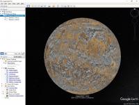
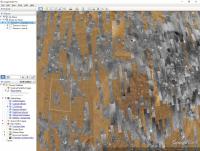
Searching Alan Boyle's twitter posts I chanced upon a post by Thomas Schumann. At the EPSC-DPS 2019 Joint Meeting the late Dr. Wei Yan gave a presentation about China's first Mars mission. One of the slides clearly shows two landing sites in Utopia Planitia. Thomas also says "As far as I've understood, the Chinese will evaluate final landing sites once in orbit."
Here is a Google Mars globe with the CTX map made available by Google (see the side bar for how to enable the CTX global map) and those two areas marked, and a closer view that shows Area A has very little coverage. However, Google has not mapped every CTX image, so other images may be available (as well as from the HiRISE camera).
This is the kmz file I used to mark the areas.  Tianwen_1_CandidateLandingAreas.kmz ( 876bytes )
Number of downloads: 605
Tianwen_1_CandidateLandingAreas.kmz ( 876bytes )
Number of downloads: 605Fernando |
||
|
|
|
||
|
Jul 24 2020, 06:32 PM
Post
#3
|
|||
 Member Group: Members Posts: 241 Joined: 13-October 09 From: Olympus Mons Member No.: 4972 |
QUOTE (nogal @ Jul 24 2020, 12:14 PM)  Searching Alan Boyle's twitter posts I chanced upon a post by Thomas Schumann. At the EPSC-DPS 2019 Joint Meeting the late Dr. Wei Yan gave a presentation about China's first Mars mission. One of the slides clearly shows two landing sites in Utopia Planitia. Thomas also says "As far as I've understood, the Chinese will evaluate final landing sites once in orbit." Here is a Google Mars globe with the CTX map made available by Google (see the side bar for how to enable the CTX global map) and those two areas marked, and a closer view that shows Area A has very little coverage. However, Google has not mapped every CTX image, so other images may be available (as well as from the HiRISE camera).
This is the kmz file I used to mark the areas.
Tianwen_1_CandidateLandingAreas.kmz ( 876bytes )
Number of downloads: 605Fernando Quite true, Google's CTX layer is 9 years old and MRO has since mapped almost the entire planet with it aside from a couple tiny areas in the poles https://themis.asu.edu/maps I used this site to find HiRise and CTX images that are not available in GE, (though I wish you could sort by year it's hard to find pre-post landing pictures when there's 100s of HiRISE images saturating a location) -------------------- "Thats no moon... IT'S A TRAP!"
|
||
|
|
|
||
 Stu Tianwen-1- Development Nov 4 2008, 08:53 AM
 remcook Next year already! It looks like it's been... Nov 4 2008, 09:51 AM Zvezdichko During the press conference in BAS it was confirme... Nov 4 2008, 11:40 AM mps already discussed in Phobos-Grunt topic two years ... Nov 4 2008, 12:07 PM remcook aaah yes I forgot about that. I imagined a stand-a... Nov 4 2008, 12:11 PM Zvezdichko There may be in the future, but the Chinese space ... Nov 4 2008, 12:23 PM mps Some new details about Yinghuo-1:
QUOTE designers ... Dec 10 2008, 09:08 AM Paolo Apparently, the Chinese delegation at this year... Nov 1 2009, 10:48 AM Paolo A rather technical paper on YH-1 "An Emulatio... Feb 16 2010, 05:57 PM Paolo Lots of papers (freely accessible but in Chinese) ... Jul 24 2010, 08:51 PM Paolo I was finally able to get a copy of the two papers... Aug 30 2010, 05:21 PM Paolo I have long been monitoring Chinese technical publ... Oct 31 2010, 01:17 PM Paolo A short, popular article (in French) on Chinese Ma... Nov 7 2010, 09:02 AM Paolo in preparation for the flight, the Chinese have pu... Jan 6 2011, 09:43 PM Paolo I found these pictures on a French forum. I think ... Mar 10 2011, 07:54 PM Paolo another Chinese Journal of Space Science paper on ... May 14 2011, 08:21 AM Paolo two fantastic pdfs found on the Novosti Kosmonavti... Sep 24 2011, 01:56 PM
remcook Next year already! It looks like it's been... Nov 4 2008, 09:51 AM Zvezdichko During the press conference in BAS it was confirme... Nov 4 2008, 11:40 AM mps already discussed in Phobos-Grunt topic two years ... Nov 4 2008, 12:07 PM remcook aaah yes I forgot about that. I imagined a stand-a... Nov 4 2008, 12:11 PM Zvezdichko There may be in the future, but the Chinese space ... Nov 4 2008, 12:23 PM mps Some new details about Yinghuo-1:
QUOTE designers ... Dec 10 2008, 09:08 AM Paolo Apparently, the Chinese delegation at this year... Nov 1 2009, 10:48 AM Paolo A rather technical paper on YH-1 "An Emulatio... Feb 16 2010, 05:57 PM Paolo Lots of papers (freely accessible but in Chinese) ... Jul 24 2010, 08:51 PM Paolo I was finally able to get a copy of the two papers... Aug 30 2010, 05:21 PM Paolo I have long been monitoring Chinese technical publ... Oct 31 2010, 01:17 PM Paolo A short, popular article (in French) on Chinese Ma... Nov 7 2010, 09:02 AM Paolo in preparation for the flight, the Chinese have pu... Jan 6 2011, 09:43 PM Paolo I found these pictures on a French forum. I think ... Mar 10 2011, 07:54 PM Paolo another Chinese Journal of Space Science paper on ... May 14 2011, 08:21 AM Paolo two fantastic pdfs found on the Novosti Kosmonavti... Sep 24 2011, 01:56 PM
 Paolo by the way, the probe and its mission look remarka... Dec 28 2012, 09:22 AM Paolo a Chinese Journal of Space Sciences paper on Mars ... Mar 28 2012, 08:06 PM yaohua2000 2018 Mars mission
http://www.nrscc.gov.cn/nrscc/k... Dec 28 2012, 04:40 AM monty python Do I see aerobreaking down the orbit? It would he... Dec 28 2012, 09:04 AM Cosmic Penguin I have recently seen rumors that a 2018 Chinese Ma... Aug 9 2013, 05:40 PM Paolo JPL rover driver Scott Maxwell has a nice analysis... Nov 9 2014, 10:20 AM tolis QUOTE (Paolo @ Nov 9 2014, 11:20 AM) JPL ... Nov 9 2014, 11:47 AM elakdawalla QUOTE (Paolo @ Nov 9 2014, 02:20 AM) JPL ... Nov 9 2014, 08:38 PM nprev It seems kinda streamlined, for some odd reason. M... Nov 9 2014, 10:39 PM Paolo ESA too was showing a streamlined ExoMars rover at... Nov 9 2014, 10:49 PM Yeh It looks like the Mars 2020 mission has got a GO f... Dec 7 2014, 11:14 PM Paolo the Chinese Mars mission has been officially appro... Apr 22 2016, 03:48 PM tolis QUOTE (Paolo @ Apr 22 2016, 03:48 PM) the... Apr 22 2016, 05:25 PM Paolo lots of papers on Mars exploration in the latest i... Jun 17 2016, 09:20 AM colin_wilson Hi - A few news outlets are carrying stories about... Aug 24 2016, 12:10 PM Steve G Nothing concrete on the experiment package that I ... Aug 24 2016, 11:31 PM Explorer1 Interesting that the egress is the same as the lun... Aug 25 2016, 01:02 AM bobik Candidate Landing Sites Jun 28 2018, 12:32 PM Phil Stooke Is this the only thread we have on this mission? ... Apr 24 2020, 03:19 AM nprev Topic renamed to reflect mission name. Thanks, Phi... Apr 25 2020, 06:29 AM Xerxes -yihao is just how you pronounce -1 in Chinese. Th... Apr 25 2020, 06:13 PM Phil Stooke Assuming we have a successful landing, I will be m... Jul 20 2020, 05:48 PM Steve G I've been unable to find if the lander will be... Jul 22 2020, 09:37 PM Phil Stooke As far as I can tell from images of the lander, th... Jul 22 2020, 11:58 PM vjkane QUOTE (Phil Stooke @ Jul 22 2020, 03:58 P... Jul 23 2020, 07:40 PM Phil Stooke The slide with those landing sites shows two boxes... Jul 24 2020, 04:59 PM nogal Thank you Phil. Do keep me honest!
The box... Jul 24 2020, 05:38 PM Phil Stooke http://murray-lab.caltech.edu/CTX/
This is a link... Jul 25 2020, 12:58 AM nogal Many thanks for the link Phil.
Laura Kerber had... Jul 25 2020, 12:24 PM Hungry4info There's a video here talking about the rover -... Jul 27 2020, 09:42 PM Phil Stooke http://9ifly.spacety.com/forum.php?mod=vie...ge=84... Jul 28 2020, 12:01 AM Paolo I don't think this paper on TW-1 has been ment... Jul 28 2020, 07:14 AM Phil Stooke http://9ifly.spacety.com/thread-93048-85-1.html
P... Jul 28 2020, 02:28 PM Lucas Neat! Hopefully thats the Moon or else were ... Jul 29 2020, 01:19 PM Phil Stooke Quick look at the coordinates recently suggested i... Jul 30 2020, 10:23 PM Phil Stooke This is the area around that identified point - th... Jul 31 2020, 03:14 AM nprev Hmm. Looks a bit dusty (shocker). All those short ... Jul 31 2020, 06:59 AM vikingmars There are lots of pingos south of this site : mayb... Jul 31 2020, 09:13 AM spacepoint Here is some info about mission and rover itself.
... Jul 31 2020, 01:50 PM Phil Stooke "All those short white streaks are more than ... Jul 31 2020, 06:19 PM volcanopele Thanks for posting the central coordinates, Phil, ... Aug 1 2020, 05:14 AM marsophile https://twitter.com/Tschnn/status/1174667085915598... Aug 6 2020, 05:13 AM tolis Even if it were possible to land or rove to the VL... Aug 6 2020, 07:52 AM JRehling Or just land there in the first place. Aug 16 2020, 05:43 PM Phil Stooke Viking 2 would never have gone to its site if the ... Aug 16 2020, 06:27 PM Hungry4info The Tianwen-1 rover will be named .... Perseveranc... Jan 18 2021, 11:45 PM Xerxes Since 弘毅 is pronounced "Hongyi... Jan 19 2021, 02:32 PM Phil Stooke Fear not, people of Earth. Yutu 2 didn't get ... Jan 19 2021, 03:28 AM HSchirmer QUOTE (Phil Stooke @ Jan 19 2021, 03:28 A... Jan 19 2021, 05:44 AM Phil Stooke Mars from Tianwen-1:
https://9ifly.spacety.com/da... Feb 5 2021, 04:20 PM Paolo b&w and better resolution
https://mp.weixin.q... Feb 5 2021, 05:35 PM nprev Congratulations to CNSA! Exciting times indeed... Feb 10 2021, 04:37 PM
Paolo by the way, the probe and its mission look remarka... Dec 28 2012, 09:22 AM Paolo a Chinese Journal of Space Sciences paper on Mars ... Mar 28 2012, 08:06 PM yaohua2000 2018 Mars mission
http://www.nrscc.gov.cn/nrscc/k... Dec 28 2012, 04:40 AM monty python Do I see aerobreaking down the orbit? It would he... Dec 28 2012, 09:04 AM Cosmic Penguin I have recently seen rumors that a 2018 Chinese Ma... Aug 9 2013, 05:40 PM Paolo JPL rover driver Scott Maxwell has a nice analysis... Nov 9 2014, 10:20 AM tolis QUOTE (Paolo @ Nov 9 2014, 11:20 AM) JPL ... Nov 9 2014, 11:47 AM elakdawalla QUOTE (Paolo @ Nov 9 2014, 02:20 AM) JPL ... Nov 9 2014, 08:38 PM nprev It seems kinda streamlined, for some odd reason. M... Nov 9 2014, 10:39 PM Paolo ESA too was showing a streamlined ExoMars rover at... Nov 9 2014, 10:49 PM Yeh It looks like the Mars 2020 mission has got a GO f... Dec 7 2014, 11:14 PM Paolo the Chinese Mars mission has been officially appro... Apr 22 2016, 03:48 PM tolis QUOTE (Paolo @ Apr 22 2016, 03:48 PM) the... Apr 22 2016, 05:25 PM Paolo lots of papers on Mars exploration in the latest i... Jun 17 2016, 09:20 AM colin_wilson Hi - A few news outlets are carrying stories about... Aug 24 2016, 12:10 PM Steve G Nothing concrete on the experiment package that I ... Aug 24 2016, 11:31 PM Explorer1 Interesting that the egress is the same as the lun... Aug 25 2016, 01:02 AM bobik Candidate Landing Sites Jun 28 2018, 12:32 PM Phil Stooke Is this the only thread we have on this mission? ... Apr 24 2020, 03:19 AM nprev Topic renamed to reflect mission name. Thanks, Phi... Apr 25 2020, 06:29 AM Xerxes -yihao is just how you pronounce -1 in Chinese. Th... Apr 25 2020, 06:13 PM Phil Stooke Assuming we have a successful landing, I will be m... Jul 20 2020, 05:48 PM Steve G I've been unable to find if the lander will be... Jul 22 2020, 09:37 PM Phil Stooke As far as I can tell from images of the lander, th... Jul 22 2020, 11:58 PM vjkane QUOTE (Phil Stooke @ Jul 22 2020, 03:58 P... Jul 23 2020, 07:40 PM Phil Stooke The slide with those landing sites shows two boxes... Jul 24 2020, 04:59 PM nogal Thank you Phil. Do keep me honest!
The box... Jul 24 2020, 05:38 PM Phil Stooke http://murray-lab.caltech.edu/CTX/
This is a link... Jul 25 2020, 12:58 AM nogal Many thanks for the link Phil.
Laura Kerber had... Jul 25 2020, 12:24 PM Hungry4info There's a video here talking about the rover -... Jul 27 2020, 09:42 PM Phil Stooke http://9ifly.spacety.com/forum.php?mod=vie...ge=84... Jul 28 2020, 12:01 AM Paolo I don't think this paper on TW-1 has been ment... Jul 28 2020, 07:14 AM Phil Stooke http://9ifly.spacety.com/thread-93048-85-1.html
P... Jul 28 2020, 02:28 PM Lucas Neat! Hopefully thats the Moon or else were ... Jul 29 2020, 01:19 PM Phil Stooke Quick look at the coordinates recently suggested i... Jul 30 2020, 10:23 PM Phil Stooke This is the area around that identified point - th... Jul 31 2020, 03:14 AM nprev Hmm. Looks a bit dusty (shocker). All those short ... Jul 31 2020, 06:59 AM vikingmars There are lots of pingos south of this site : mayb... Jul 31 2020, 09:13 AM spacepoint Here is some info about mission and rover itself.
... Jul 31 2020, 01:50 PM Phil Stooke "All those short white streaks are more than ... Jul 31 2020, 06:19 PM volcanopele Thanks for posting the central coordinates, Phil, ... Aug 1 2020, 05:14 AM marsophile https://twitter.com/Tschnn/status/1174667085915598... Aug 6 2020, 05:13 AM tolis Even if it were possible to land or rove to the VL... Aug 6 2020, 07:52 AM JRehling Or just land there in the first place. Aug 16 2020, 05:43 PM Phil Stooke Viking 2 would never have gone to its site if the ... Aug 16 2020, 06:27 PM Hungry4info The Tianwen-1 rover will be named .... Perseveranc... Jan 18 2021, 11:45 PM Xerxes Since 弘毅 is pronounced "Hongyi... Jan 19 2021, 02:32 PM Phil Stooke Fear not, people of Earth. Yutu 2 didn't get ... Jan 19 2021, 03:28 AM HSchirmer QUOTE (Phil Stooke @ Jan 19 2021, 03:28 A... Jan 19 2021, 05:44 AM Phil Stooke Mars from Tianwen-1:
https://9ifly.spacety.com/da... Feb 5 2021, 04:20 PM Paolo b&w and better resolution
https://mp.weixin.q... Feb 5 2021, 05:35 PM nprev Congratulations to CNSA! Exciting times indeed... Feb 10 2021, 04:37 PM |

|
Lo-Fi Version | Time is now: 23rd September 2024 - 10:52 AM |
|
RULES AND GUIDELINES Please read the Forum Rules and Guidelines before posting. IMAGE COPYRIGHT |
OPINIONS AND MODERATION Opinions expressed on UnmannedSpaceflight.com are those of the individual posters and do not necessarily reflect the opinions of UnmannedSpaceflight.com or The Planetary Society. The all-volunteer UnmannedSpaceflight.com moderation team is wholly independent of The Planetary Society. The Planetary Society has no influence over decisions made by the UnmannedSpaceflight.com moderators. |
SUPPORT THE FORUM Unmannedspaceflight.com is funded by the Planetary Society. Please consider supporting our work and many other projects by donating to the Society or becoming a member. |
|