InSight maps |

InSight maps |
 Dec 21 2018, 08:27 AM Dec 21 2018, 08:27 AM
Post
#1
|
||
|
Solar System Cartographer  Group: Members Posts: 10166 Joined: 5-April 05 From: Canada Member No.: 227 |
I am setting this up to contain maps of the InSight landing site, but at this stage it is hard to know exactly what form they will take. I hope to have a map of the 20 m or so around the lander with a few feature names if any are assigned, and maps of the workspace showing operations step by step. Maps showing the locations of distant features on the horizon might also be added.
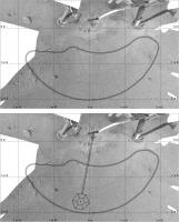
To start off, here is a very preliminary map of the workspace and the area under the front of the lander, which will improve as more images are added to cover parts blocked by struts. The lower image shows the SEIS position, as accurately as I can get it now. I put north at the top. The scale and orientation are from a map in a recent paper about the arm and the base is from the JPL press release image, the two being registered to match the workspace outline which is shown in both. Doug's map is rotated slightly compared with this. Phil
-------------------- ... because the Solar System ain't gonna map itself.
Also to be found posting similar content on https://mastodon.social/@PhilStooke Maps for download (free PD: https://upload.wikimedia.org/wikipedia/comm...Cartography.pdf NOTE: everything created by me which I post on UMSF is considered to be in the public domain (NOT CC, public domain) |
|
 |
 
|
|
 |
|
Oct 13 2020, 06:23 PM
Post
#2
|
||||
|
Solar System Cartographer Group: Members Posts: 10166 Joined: 5-April 05 From: Canada Member No.: 227 |
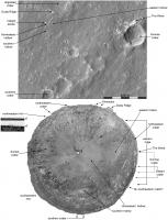
InSight has been on Mars for one Mars year now, and a new paper gives us details of the landing site including feature names:
https://agupubs.onlinelibrary.wiley.com/doi...29/2020EA001248 (it's open access) To celebrate the birthday here are 3 illustrations of the landing site which include the newly published names (other rock names near the lander will be in a future update) as well as more details of horizon feature identifications using additional even more informal names from me. Phil
-------------------- ... because the Solar System ain't gonna map itself.
Also to be found posting similar content on https://mastodon.social/@PhilStooke Maps for download (free PD: https://upload.wikimedia.org/wikipedia/comm...Cartography.pdf NOTE: everything created by me which I post on UMSF is considered to be in the public domain (NOT CC, public domain) |
|||
|
|
|
|||
 Phil Stooke InSight maps Dec 21 2018, 08:27 AM
 Phil Stooke A few adjustments to my map. I hope to be able to... Jan 3 2019, 12:37 AM Phil Stooke Not much new at the moment but I have added labels... Jan 10 2019, 11:29 PM Phil Stooke Updating these maps, I have added the names of two... Feb 6 2019, 12:58 AM Phil Stooke Update to the map showing the HP3 deployment - my ... Feb 18 2019, 07:27 PM
 kenny QUOTE (Phil Stooke @ Feb 18 2019, 07:27 P... Feb 18 2019, 07:58 PM Phil Stooke OK, more maps! Here are two more in the time ... Jun 29 2019, 11:40 PM Phil Stooke It's been a while since I added anything here,... Feb 13 2020, 12:23 AM Phil Stooke This image shows progress towards a map of the InS... Mar 28 2020, 10:00 PM Phil Stooke This map has been driving me nuts for months but i... Dec 12 2020, 12:20 AM Phil Stooke And this is a corrected version of the map in the ... Dec 12 2020, 03:52 AM Phil Stooke Turns out that map up above was not the last. Her... Mar 2 2021, 09:40 PM Phil Stooke It's been a long time since anything was poste... Feb 28 2022, 07:41 PM Phil Stooke This is the end of mission workspace map. I am wo... Dec 29 2022, 02:24 AM
 |

|
Lo-Fi Version | Time is now: 23rd May 2024 - 04:10 PM |
|
RULES AND GUIDELINES Please read the Forum Rules and Guidelines before posting. IMAGE COPYRIGHT |
OPINIONS AND MODERATION Opinions expressed on UnmannedSpaceflight.com are those of the individual posters and do not necessarily reflect the opinions of UnmannedSpaceflight.com or The Planetary Society. The all-volunteer UnmannedSpaceflight.com moderation team is wholly independent of The Planetary Society. The Planetary Society has no influence over decisions made by the UnmannedSpaceflight.com moderators. |
SUPPORT THE FORUM Unmannedspaceflight.com is funded by the Planetary Society. Please consider supporting our work and many other projects by donating to the Society or becoming a member. |
|