Chang'e 5 sample return mission |

Chang'e 5 sample return mission |
 Oct 24 2012, 01:02 PM Oct 24 2012, 01:02 PM
Post
#1
|
|
|
Solar System Cartographer  Group: Members Posts: 10226 Joined: 5-April 05 From: Canada Member No.: 227 |
Of course, a mechanical or electronic failure is likely to end the mission long before the RTG wears out (same as on Curiosity)
Phil -------------------- ... because the Solar System ain't gonna map itself.
Also to be found posting similar content on https://mastodon.social/@PhilStooke Maps for download (free PDF: https://upload.wikimedia.org/wikipedia/comm...Cartography.pdf NOTE: everything created by me which I post on UMSF is considered to be in the public domain (NOT CC, public domain) |
 |
 
|
 |
|
Nov 6 2012, 12:28 AM
Post
#2
|
||
|
Junior Member Group: Members Posts: 86 Joined: 12-October 05 From: Beijing Member No.: 526 |
Chang'e 5 atmospheric re-entry and parachute ejection system tested.
Attached thumbnail(s)
|
|
|
|
|
|
|
Dec 2 2020, 04:55 AM
Post
#3
|
||
|
Solar System Cartographer Group: Members Posts: 10226 Joined: 5-April 05 From: Canada Member No.: 227 |
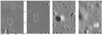
A quick finder image sequence. The name of the hill, apparently just visible on the horizon in one view, is informal. Hills were formerly named from a nearby crater plus a Greek letter, and a few are still in use (Hansteen Alpha, for instance, and the only really official one, Hadley Delta), and those names are on the Apollo-era maps, but they are not official today (a mistake in my opinion).
Phil
-------------------- ... because the Solar System ain't gonna map itself.
Also to be found posting similar content on https://mastodon.social/@PhilStooke Maps for download (free PDF: https://upload.wikimedia.org/wikipedia/comm...Cartography.pdf NOTE: everything created by me which I post on UMSF is considered to be in the public domain (NOT CC, public domain) |
|
|
|
|
|
|
Dec 3 2020, 04:45 AM
Post
#4
|
||
|
Junior Member Group: Members Posts: 38 Joined: 7-October 20 Member No.: 8895 |
QUOTE (Phil Stooke @ Dec 2 2020, 10:25 AM)  A quick finder image sequence. The name of the hill, apparently just visible on the horizon in one view, is informal. Hills were formerly named from a nearby crater plus a Greek letter, and a few are still in use (Hansteen Alpha, for instance, and the only really official one, Hadley Delta), and those names are on the Apollo-era maps, but they are not official today (a mistake in my opinion). Phil
The hill is 20km away and at a height of 500m from the surface but they are still visible.. (After seeing these images I believe Luna9 might be 30 ~ 40 kms away from Planitia Descensus & the hills seen on it might be very well Planitia Descensus itself) now working on to enhance the landing image from LROC |
|
|
|
|
|
 yaohua2000 Chang'e 5 sample return mission Nov 6 2012, 12:28 AM
 Phil Stooke I have located the second image now, on the wester... Mar 15 2017, 02:20 PM Phil Stooke CE5-T1 second image located.
Phil
Mar 15 2017, 03:46 PM Phil Stooke I have learned some new things about the CE5 landi... Jun 22 2017, 05:13 AM Phil Stooke More on those sites later. Meanwhile, here's ... Jun 23 2017, 12:52 AM Phil Stooke Sad news. A second launch of the large new rocket... Jul 2 2017, 04:45 PM Paolo let's look at the bright side: maybe CE-4 will... Jul 2 2017, 06:37 PM Phil Stooke https://twitter.com/jeff_foust/status/912197913995... Sep 25 2017, 10:50 AM Phil Stooke Chang'E 5 T1, the mission which tested the ret... Dec 14 2017, 11:16 PM Phil Stooke Confirmation CE5 T1 is still operating in lunar or... Jan 12 2018, 07:26 AM Steve G Update on the long March 5 failure and schedule fo... Apr 16 2018, 12:34 PM Huguet Let's hope they acelerate their program due to... Jan 17 2019, 02:58 PM
Phil Stooke I have located the second image now, on the wester... Mar 15 2017, 02:20 PM Phil Stooke CE5-T1 second image located.
Phil
Mar 15 2017, 03:46 PM Phil Stooke I have learned some new things about the CE5 landi... Jun 22 2017, 05:13 AM Phil Stooke More on those sites later. Meanwhile, here's ... Jun 23 2017, 12:52 AM Phil Stooke Sad news. A second launch of the large new rocket... Jul 2 2017, 04:45 PM Paolo let's look at the bright side: maybe CE-4 will... Jul 2 2017, 06:37 PM Phil Stooke https://twitter.com/jeff_foust/status/912197913995... Sep 25 2017, 10:50 AM Phil Stooke Chang'E 5 T1, the mission which tested the ret... Dec 14 2017, 11:16 PM Phil Stooke Confirmation CE5 T1 is still operating in lunar or... Jan 12 2018, 07:26 AM Steve G Update on the long March 5 failure and schedule fo... Apr 16 2018, 12:34 PM Huguet Let's hope they acelerate their program due to... Jan 17 2019, 02:58 PM
 SpaceListener QUOTE (Huguet @ Jan 17 2019, 08:58 AM) Le... Jan 17 2019, 03:22 PM nogal Quote from the ESA "Beckoning Moon" post... Jan 25 2019, 10:38 PM Thorsten Denk Long March 5 return to flight in July.
If all goes... Jan 29 2019, 12:49 PM Huguet https://futurism.com/the-byte/china-launche...-mar... Dec 31 2019, 01:42 PM Paolo some scientific results from the lunar orbiting ph... Apr 17 2020, 05:22 PM Huguet Andrew Jones - https://twitter.com/AJ_FI/status/12... Jul 23 2020, 12:23 PM Phil Stooke Launch next week! Here's an interesting p... Nov 19 2020, 05:19 AM nogal QUOTE (Phil Stooke @ Nov 19 2020, 05:19 A... Nov 19 2020, 06:21 PM Phil Stooke I forgot to mention in my recent post that there i... Nov 21 2020, 08:39 PM Thorsten Denk Possible Cháng'é 5 timeline (in UTC). From ... Nov 23 2020, 08:33 AM Greenish QUOTE (Thorsten Denk @ Nov 23 2020, 03:33... Nov 30 2020, 03:24 PM Ron Hobbs From an article by Sam McNeil in the Washington Po... Nov 23 2020, 03:21 PM Ron Hobbs CGTN is webcasting live coverage of the Chang... Nov 23 2020, 07:44 PM nprev Anybody have a link?
EDIT: Here. Nov 23 2020, 08:12 PM nprev Spacecraft sep. Looks like a sweet launch. Here... Nov 23 2020, 09:25 PM Huguet Solar arrays deployed, the chinese are pretty conf... Nov 24 2020, 09:17 AM fredk S&T reports landing planned for "on or ar... Nov 24 2020, 05:53 PM Brian Swift Solar panel video from data captured and decoded b... Nov 25 2020, 08:24 PM Explorer1 Nice work for them! This is like the Luna 9 su... Nov 25 2020, 09:38 PM kenny Latest news from South China Morning Post (Hong Ko... Nov 26 2020, 10:27 PM Phil Stooke I think the '10 kg load for international part... Nov 26 2020, 11:01 PM Huguet Or instead of making pounds -> kg (4.4lb -> ... Nov 27 2020, 09:40 AM nogal Chang'e-5 has just successfully achieved an el... Nov 28 2020, 03:25 PM kenny The Xinhua news agency reports more precisely that... Nov 29 2020, 09:54 AM nogal From CNSA http://www.cnsa.gov.cn/n6758823/n675883... Nov 29 2020, 07:19 PM Holder of the Two Leashes Here is the article in English:
CGTN
"The ... Nov 29 2020, 09:51 PM Hungry4info Chang'e 5 lander as seen from the orbiter. It... Nov 30 2020, 03:53 AM Phil Stooke Repost of an old image of the landing site. The b... Nov 30 2020, 04:29 PM kenny Am I correct to assume that Chang'e 5 is in a ... Dec 1 2020, 09:06 AM Thorsten Denk No. Cháng'é-5 is in an orbit with about 45° in... Dec 1 2020, 09:14 AM kenny thank you Thorsten.
Unlike Apollo, an automatic ... Dec 1 2020, 10:12 AM Huguet Chang'e-5 Landing on The Moon Live Feed:
http... Dec 1 2020, 01:14 PM Thorsten Denk https://www.youtube.com/watch?v=IO_PsBHPRxs Dec 1 2020, 01:19 PM kenny Nothing happening on those links as far as I can s... Dec 1 2020, 03:17 PM Thorsten Denk Seems to have been successful landing!
https:/... Dec 1 2020, 03:18 PM ollopa Oh to have a rover!!! This crater loo... Dec 1 2020, 03:47 PM kymani76
Map of the landing area with reported landing si... Dec 1 2020, 04:38 PM Hungry4info Well, I've identified the landing site.
Lat: ... Dec 1 2020, 04:48 PM Hungry4info Image released from the lander looking down second... Dec 1 2020, 05:18 PM Marvin Landing sequence on YouTube via Xinhua News Agency... Dec 1 2020, 05:54 PM Antdoghalo Congratulations to the Chinese! A bright bit o... Dec 1 2020, 06:02 PM Huguet Today Moon New Population:
3 Stationary Bots
1 Ro... Dec 1 2020, 06:03 PM Marcin600 drilling has started (?) - here Dec 1 2020, 07:44 PM Phil Stooke Scrambling to catch up here. Thanks for all the g... Dec 1 2020, 09:35 PM AndyG QUOTE (Phil Stooke @ Dec 1 2020, 10:35 PM... Dec 1 2020, 10:24 PM Explorer1 Coverage on CGTN starting in a few minutes at http... Dec 2 2020, 01:53 AM Hungry4info I'm sure we'll get some better images soon... Dec 2 2020, 02:48 AM Hungry4info Transfer of material from the sample acquisition d... Dec 2 2020, 03:15 AM Hungry4info Horizon! Dec 2 2020, 03:22 AM Paolo QUOTE (Hungry4info @ Dec 2 2020, 04:22 AM... Dec 2 2020, 07:47 AM Hungry4info Looks like they've completed another scoop, wh... Dec 2 2020, 03:29 AM Phil Stooke My hero! Thanks for all this.
Phil Dec 2 2020, 03:51 AM Hungry4info Here's a video that shows many of the activiti... Dec 2 2020, 04:35 AM Phil Stooke It does, but I'm having a hard time finding it... Dec 2 2020, 08:24 AM Hungry4info I think it's the other way around. The camera ... Dec 2 2020, 09:38 AM Paolo clearly you are right! I've been fooled by... Dec 2 2020, 10:37 AM kenny That pair of photos remind me of the early picture... Dec 2 2020, 12:17 PM Marcin600 On the official website of the CNSA (China Nationa... Dec 2 2020, 12:22 PM Marcin600 panorama - from here
here is this picture in high... Dec 2 2020, 01:32 PM Marcin600 Here (from 0:00 to 0:30 with commentary in Russian... Dec 2 2020, 01:37 PM Marcin600 From here and here: Dec 2 2020, 01:47 PM Marcin600 Here is a landing video and almost complete drilli... Dec 2 2020, 02:23 PM Phil Stooke Hungry4info: "I think it's the other way ... Dec 2 2020, 04:14 PM Greenish I don't think Mattias Malmer posts here much a... Dec 2 2020, 05:08 PM Marcin600 Here is the complete landing sequence in pretty go... Dec 2 2020, 05:25 PM Hungry4info I think these are some of the frames used to make ... Dec 2 2020, 05:58 PM Marcin600 Other fragments of the "big panorama".
... Dec 2 2020, 06:30 PM kymani76
New map of yesterday's landing..I had a bit ... Dec 2 2020, 06:32 PM Shan QUOTE (kymani76 @ Dec 3 2020, 12:02 AM)
... Dec 3 2020, 06:04 AM Marcin600 I don't know if it is just my imagination, but... Dec 2 2020, 08:28 PM Marcin600 And something preventive against conspiracy theori... Dec 2 2020, 08:29 PM nprev Marcin600, good catch re conspiracy theory prevent... Dec 2 2020, 09:30 PM Phil Stooke Another Phil, this time Phil Metzger of the Univer... Dec 2 2020, 10:03 PM neo56 QUOTE (Phil Stooke @ Dec 2 2020, 11:03 PM... Dec 3 2020, 08:14 AM Marcin600 Oh yes, conspiracy theories probably do more damag... Dec 2 2020, 11:03 PM Hungry4info Here's the full resolution panorama. (15000 x ... Dec 2 2020, 11:22 PM machi Horizontal panorama with averaged white balance an... Dec 3 2020, 12:25 AM nprev Niiiice, Machi!!!!
Phil, apolo... Dec 3 2020, 12:46 AM machi Thanks Nick! Dec 3 2020, 12:53 AM Phil Stooke https://mp.weixin.qq.com/s/3qKItsZIBRg43uwYxBeqsQ
... Dec 3 2020, 02:24 AM Phil Stooke http://www.xinhuanet.com/2020-12/03/c_1126816223.h... Dec 3 2020, 03:49 AM Phil Stooke I have been looking at these scooping images and v... Dec 3 2020, 05:27 AM Marcin600 From CNSA (China National Space Administration) s... Dec 3 2020, 12:10 PM Shan Enhanced LRO image M1219279265LE with Chang'e5... Dec 3 2020, 01:30 PM Thorsten Denk Maybe they catch the launch?
(Just kidding...)
Th... Dec 3 2020, 01:35 PM Marcin600 According to this post by Andrew Jones - https://t... Dec 3 2020, 02:03 PM Huguet Positive Launch!!!
Crazy time in shad... Dec 3 2020, 03:23 PM
SpaceListener QUOTE (Huguet @ Jan 17 2019, 08:58 AM) Le... Jan 17 2019, 03:22 PM nogal Quote from the ESA "Beckoning Moon" post... Jan 25 2019, 10:38 PM Thorsten Denk Long March 5 return to flight in July.
If all goes... Jan 29 2019, 12:49 PM Huguet https://futurism.com/the-byte/china-launche...-mar... Dec 31 2019, 01:42 PM Paolo some scientific results from the lunar orbiting ph... Apr 17 2020, 05:22 PM Huguet Andrew Jones - https://twitter.com/AJ_FI/status/12... Jul 23 2020, 12:23 PM Phil Stooke Launch next week! Here's an interesting p... Nov 19 2020, 05:19 AM nogal QUOTE (Phil Stooke @ Nov 19 2020, 05:19 A... Nov 19 2020, 06:21 PM Phil Stooke I forgot to mention in my recent post that there i... Nov 21 2020, 08:39 PM Thorsten Denk Possible Cháng'é 5 timeline (in UTC). From ... Nov 23 2020, 08:33 AM Greenish QUOTE (Thorsten Denk @ Nov 23 2020, 03:33... Nov 30 2020, 03:24 PM Ron Hobbs From an article by Sam McNeil in the Washington Po... Nov 23 2020, 03:21 PM Ron Hobbs CGTN is webcasting live coverage of the Chang... Nov 23 2020, 07:44 PM nprev Anybody have a link?
EDIT: Here. Nov 23 2020, 08:12 PM nprev Spacecraft sep. Looks like a sweet launch. Here... Nov 23 2020, 09:25 PM Huguet Solar arrays deployed, the chinese are pretty conf... Nov 24 2020, 09:17 AM fredk S&T reports landing planned for "on or ar... Nov 24 2020, 05:53 PM Brian Swift Solar panel video from data captured and decoded b... Nov 25 2020, 08:24 PM Explorer1 Nice work for them! This is like the Luna 9 su... Nov 25 2020, 09:38 PM kenny Latest news from South China Morning Post (Hong Ko... Nov 26 2020, 10:27 PM Phil Stooke I think the '10 kg load for international part... Nov 26 2020, 11:01 PM Huguet Or instead of making pounds -> kg (4.4lb -> ... Nov 27 2020, 09:40 AM nogal Chang'e-5 has just successfully achieved an el... Nov 28 2020, 03:25 PM kenny The Xinhua news agency reports more precisely that... Nov 29 2020, 09:54 AM nogal From CNSA http://www.cnsa.gov.cn/n6758823/n675883... Nov 29 2020, 07:19 PM Holder of the Two Leashes Here is the article in English:
CGTN
"The ... Nov 29 2020, 09:51 PM Hungry4info Chang'e 5 lander as seen from the orbiter. It... Nov 30 2020, 03:53 AM Phil Stooke Repost of an old image of the landing site. The b... Nov 30 2020, 04:29 PM kenny Am I correct to assume that Chang'e 5 is in a ... Dec 1 2020, 09:06 AM Thorsten Denk No. Cháng'é-5 is in an orbit with about 45° in... Dec 1 2020, 09:14 AM kenny thank you Thorsten.
Unlike Apollo, an automatic ... Dec 1 2020, 10:12 AM Huguet Chang'e-5 Landing on The Moon Live Feed:
http... Dec 1 2020, 01:14 PM Thorsten Denk https://www.youtube.com/watch?v=IO_PsBHPRxs Dec 1 2020, 01:19 PM kenny Nothing happening on those links as far as I can s... Dec 1 2020, 03:17 PM Thorsten Denk Seems to have been successful landing!
https:/... Dec 1 2020, 03:18 PM ollopa Oh to have a rover!!! This crater loo... Dec 1 2020, 03:47 PM kymani76
Map of the landing area with reported landing si... Dec 1 2020, 04:38 PM Hungry4info Well, I've identified the landing site.
Lat: ... Dec 1 2020, 04:48 PM Hungry4info Image released from the lander looking down second... Dec 1 2020, 05:18 PM Marvin Landing sequence on YouTube via Xinhua News Agency... Dec 1 2020, 05:54 PM Antdoghalo Congratulations to the Chinese! A bright bit o... Dec 1 2020, 06:02 PM Huguet Today Moon New Population:
3 Stationary Bots
1 Ro... Dec 1 2020, 06:03 PM Marcin600 drilling has started (?) - here Dec 1 2020, 07:44 PM Phil Stooke Scrambling to catch up here. Thanks for all the g... Dec 1 2020, 09:35 PM AndyG QUOTE (Phil Stooke @ Dec 1 2020, 10:35 PM... Dec 1 2020, 10:24 PM Explorer1 Coverage on CGTN starting in a few minutes at http... Dec 2 2020, 01:53 AM Hungry4info I'm sure we'll get some better images soon... Dec 2 2020, 02:48 AM Hungry4info Transfer of material from the sample acquisition d... Dec 2 2020, 03:15 AM Hungry4info Horizon! Dec 2 2020, 03:22 AM Paolo QUOTE (Hungry4info @ Dec 2 2020, 04:22 AM... Dec 2 2020, 07:47 AM Hungry4info Looks like they've completed another scoop, wh... Dec 2 2020, 03:29 AM Phil Stooke My hero! Thanks for all this.
Phil Dec 2 2020, 03:51 AM Hungry4info Here's a video that shows many of the activiti... Dec 2 2020, 04:35 AM Phil Stooke It does, but I'm having a hard time finding it... Dec 2 2020, 08:24 AM Hungry4info I think it's the other way around. The camera ... Dec 2 2020, 09:38 AM Paolo clearly you are right! I've been fooled by... Dec 2 2020, 10:37 AM kenny That pair of photos remind me of the early picture... Dec 2 2020, 12:17 PM Marcin600 On the official website of the CNSA (China Nationa... Dec 2 2020, 12:22 PM Marcin600 panorama - from here
here is this picture in high... Dec 2 2020, 01:32 PM Marcin600 Here (from 0:00 to 0:30 with commentary in Russian... Dec 2 2020, 01:37 PM Marcin600 From here and here: Dec 2 2020, 01:47 PM Marcin600 Here is a landing video and almost complete drilli... Dec 2 2020, 02:23 PM Phil Stooke Hungry4info: "I think it's the other way ... Dec 2 2020, 04:14 PM Greenish I don't think Mattias Malmer posts here much a... Dec 2 2020, 05:08 PM Marcin600 Here is the complete landing sequence in pretty go... Dec 2 2020, 05:25 PM Hungry4info I think these are some of the frames used to make ... Dec 2 2020, 05:58 PM Marcin600 Other fragments of the "big panorama".
... Dec 2 2020, 06:30 PM kymani76
New map of yesterday's landing..I had a bit ... Dec 2 2020, 06:32 PM Shan QUOTE (kymani76 @ Dec 3 2020, 12:02 AM)
... Dec 3 2020, 06:04 AM Marcin600 I don't know if it is just my imagination, but... Dec 2 2020, 08:28 PM Marcin600 And something preventive against conspiracy theori... Dec 2 2020, 08:29 PM nprev Marcin600, good catch re conspiracy theory prevent... Dec 2 2020, 09:30 PM Phil Stooke Another Phil, this time Phil Metzger of the Univer... Dec 2 2020, 10:03 PM neo56 QUOTE (Phil Stooke @ Dec 2 2020, 11:03 PM... Dec 3 2020, 08:14 AM Marcin600 Oh yes, conspiracy theories probably do more damag... Dec 2 2020, 11:03 PM Hungry4info Here's the full resolution panorama. (15000 x ... Dec 2 2020, 11:22 PM machi Horizontal panorama with averaged white balance an... Dec 3 2020, 12:25 AM nprev Niiiice, Machi!!!!
Phil, apolo... Dec 3 2020, 12:46 AM machi Thanks Nick! Dec 3 2020, 12:53 AM Phil Stooke https://mp.weixin.qq.com/s/3qKItsZIBRg43uwYxBeqsQ
... Dec 3 2020, 02:24 AM Phil Stooke http://www.xinhuanet.com/2020-12/03/c_1126816223.h... Dec 3 2020, 03:49 AM Phil Stooke I have been looking at these scooping images and v... Dec 3 2020, 05:27 AM Marcin600 From CNSA (China National Space Administration) s... Dec 3 2020, 12:10 PM Shan Enhanced LRO image M1219279265LE with Chang'e5... Dec 3 2020, 01:30 PM Thorsten Denk Maybe they catch the launch?
(Just kidding...)
Th... Dec 3 2020, 01:35 PM Marcin600 According to this post by Andrew Jones - https://t... Dec 3 2020, 02:03 PM Huguet Positive Launch!!!
Crazy time in shad... Dec 3 2020, 03:23 PM |

|
Lo-Fi Version | Time is now: 21st September 2024 - 12:56 PM |
|
RULES AND GUIDELINES Please read the Forum Rules and Guidelines before posting. IMAGE COPYRIGHT |
OPINIONS AND MODERATION Opinions expressed on UnmannedSpaceflight.com are those of the individual posters and do not necessarily reflect the opinions of UnmannedSpaceflight.com or The Planetary Society. The all-volunteer UnmannedSpaceflight.com moderation team is wholly independent of The Planetary Society. The Planetary Society has no influence over decisions made by the UnmannedSpaceflight.com moderators. |
SUPPORT THE FORUM Unmannedspaceflight.com is funded by the Planetary Society. Please consider supporting our work and many other projects by donating to the Society or becoming a member. |
|