Juno Extended Mission, Perijove 34-76 |

Juno Extended Mission, Perijove 34-76 |
 Sep 2 2020, 08:05 PM Sep 2 2020, 08:05 PM
Post
#1
|
|
 Senior Member  Group: Moderator Posts: 3241 Joined: 11-February 04 From: Tucson, AZ Member No.: 23 |
At today's Outer Planet Assessment Group (OPAG) meeting, Scott Bolton gave a presentation on Juno, providing an update on the mission and providing more information on its extended mission proposal. The proposal has been sent to NASA and they expect a final decision later this year.
The proposed extended mission starts where the current one ends at perijove 34 in June 2021 and continues through orbit 76 in September 2025. The continued northward progression of the perijove latitude, and continued lower altitude of the ascending node, is going to enable a lot of great science both at Jupiter (higher resolution views of Jupiter's poles) and of its satellites. Most excitingly for me, Juno will perform several flybys of the Galilean satellites. This includes a 1000-km encounter with Ganymede next June during PJ34, a 320-km encounter with Europa in late 2022, and TWO Io flybys in early 2024 at an altitude of 1500 km. There are also a number of "Voyager-class" encounters with Ganymede, Europa, and Io between mid-2021 and mid-2025. The PDF for Scott Bolton's presentation can be found on the page for the OPAG meeting: https://www.lpi.usra.edu/opag/meetings/opag2020fall/ -------------------- &@^^!% Jim! I'm a geologist, not a physicist!
The Gish Bar Times - A Blog all about Jupiter's Moon Io |
 |
 
|
 |
|
Jan 12 2021, 10:24 PM
Post
#2
|
||
|
Solar System Cartographer Group: Members Posts: 10226 Joined: 5-April 05 From: Canada Member No.: 227 |
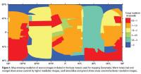
This map (from here:)
https://astrogeology.usgs.gov/search/map/Ga...IM3237_Database shows image coverage for the USGS basemap of Ganymede. There will be small areas of high resolution coverage scattered through this. It suggests to me that any swath of imaging from Juno's closest pass will improve our maps to some extent. Phil
-------------------- ... because the Solar System ain't gonna map itself.
Also to be found posting similar content on https://mastodon.social/@PhilStooke Maps for download (free PDF: https://upload.wikimedia.org/wikipedia/comm...Cartography.pdf NOTE: everything created by me which I post on UMSF is considered to be in the public domain (NOT CC, public domain) |
|
|
|
|
|
 volcanopele Juno Extended Mission Sep 2 2020, 08:05 PM
 JRehling That is exciting.
I know that the eye candy is fu... Sep 2 2020, 09:18 PM volcanopele And it won't just be eye candy with the Galile... Sep 2 2020, 09:37 PM
JRehling That is exciting.
I know that the eye candy is fu... Sep 2 2020, 09:18 PM volcanopele And it won't just be eye candy with the Galile... Sep 2 2020, 09:37 PM rlorenz QUOTE (volcanopele @ Sep 2 2020, 05:37 PM... Sep 3 2020, 02:19 AM
 JRehling I'm curious if the Europa imagery could be suf... Sep 3 2020, 05:52 AM vjkane Ralph, thanks for the dash of reality. Hope that ... Sep 3 2020, 02:50 PM rlorenz QUOTE (vjkane @ Sep 3 2020, 09:50 AM) Ral... Sep 4 2020, 03:37 AM vjkane QUOTE (rlorenz @ Sep 2 2020, 06:19 PM) I ... Sep 4 2020, 01:32 PM mcaplinger QUOTE (rlorenz @ Sep 3 2020, 07:37 PM) th... Sep 4 2020, 03:42 PM rlorenz QUOTE (mcaplinger @ Sep 4 2020, 11:42 AM)... Sep 5 2020, 02:53 AM mcaplinger QUOTE (rlorenz @ Sep 4 2020, 06:53 PM) ye... Sep 7 2020, 06:37 PM JRehling I don't have any information on planned instru... Sep 8 2020, 06:44 PM mcaplinger QUOTE (JRehling @ Sep 8 2020, 10:44 AM) t... Sep 8 2020, 07:55 PM john_s Digging up my copy of the Voyager 2 Jupiter encoun... Sep 8 2020, 08:43 PM volcanopele I agree with Mike. Putting moderator hat on...
S... Sep 4 2020, 04:04 PM Decepticon Will images be taken during Europa and Io Encounte... Sep 7 2020, 02:43 AM volcanopele The best resolution images of Europa by Voyager 2 ... Sep 8 2020, 08:44 PM Phil Stooke As Mike says there are large gaps in high resoluti... Sep 8 2020, 09:21 PM mcaplinger With regard to improving resolution, keep in mind ... Sep 8 2020, 10:32 PM Fox Am I correct that Juno doesn't photograph Call... Sep 29 2020, 10:25 PM mcaplinger QUOTE (Fox @ Sep 29 2020, 02:25 PM) Am I ... Sep 30 2020, 02:14 AM Decepticon When will the extended mission be approved or not ... Oct 19 2020, 05:47 AM vjkane QUOTE (Decepticon @ Oct 18 2020, 10:47 PM... Oct 19 2020, 12:21 PM vjkane The results of the 2020 Senior Review and NASA... Jan 8 2021, 04:58 PM mcaplinger QUOTE "Imaging observations will search for c... Jan 9 2021, 01:29 AM volcanopele Obviously I am VERY EXCITED to see this approved s... Jan 8 2021, 06:27 PM Antdoghalo Yes!!! More eye candy!!! W... Jan 8 2021, 07:32 PM Fox This is great. Will Juno be in position to capture... Jan 8 2021, 09:53 PM Decepticon QUOTE (Fox @ Jan 8 2021, 03:53 PM) This i... Jan 9 2021, 01:10 AM Antdoghalo It did, but not the unmapped area. Jan 9 2021, 12:14 AM Antdoghalo Large Swaths of Ganymede may be improved depending... Jan 9 2021, 03:21 AM mcaplinger QUOTE (Antdoghalo @ Jan 8 2021, 07:21 PM)... Jan 9 2021, 06:01 PM mcaplinger QUOTE (mcaplinger @ Jan 9 2021, 10:01 AM)... Jan 12 2021, 05:27 PM owlsyme (edited down to closest approaches)
QUOTE (mcapli... Jun 9 2021, 05:46 AM Brian Swift Mike, do you know yet if MSS will be doing any add... Jan 9 2021, 08:06 AM mcaplinger QUOTE (Brian Swift @ Jan 9 2021, 12:06 AM... Jan 9 2021, 05:18 PM antipode Magnetometer science at the Ganemedian magnetosphe... Jan 9 2021, 10:55 PM mcaplinger QUOTE (antipode @ Jan 9 2021, 02:55 PM) I... Jan 9 2021, 11:28 PM volcanopele Expect an animation of the Io encounters on YouTub... Jan 12 2021, 06:19 PM stevesliva QUOTE (volcanopele @ Jan 12 2021, 01:19 P... Jan 12 2021, 07:44 PM volcanopele Placeholder post for Io flybys based on spk_ref_21... Jan 12 2021, 06:51 PM volcanopele QUOTE (Phil Stooke @ Jan 12 2021, 03:24 P... Jan 12 2021, 10:40 PM mcaplinger QUOTE (volcanopele @ Jan 12 2021, 02:40 P... Jan 13 2021, 12:08 AM Antdoghalo QUOTE (volcanopele @ Jan 12 2021, 01:51 P... Jan 12 2021, 11:55 PM Bjorn Jonsson Ganymede was actually fairly well imaged by the Vo... Jan 13 2021, 01:40 AM volcanopele QUOTE (Bjorn Jonsson @ Jan 12 2021, 06:40... Jan 13 2021, 03:33 PM mcaplinger QUOTE (volcanopele @ Jan 13 2021, 07:33 A... Jan 13 2021, 04:52 PM Bjorn Jonsson QUOTE (volcanopele @ Jan 13 2021, 03:33 P... Jan 14 2021, 01:28 AM volcanopele Here is the simulation of the best Europa view I f... Jan 13 2021, 03:36 AM Decepticon Very excited to see Europa and Io!
Does Amal... Jan 13 2021, 07:35 AM mcaplinger QUOTE (Decepticon @ Jan 12 2021, 11:35 PM... Jan 13 2021, 04:07 PM volcanopele And even with JIRAM, Amalthea would be 25x12 pixel... Jan 13 2021, 04:31 PM Antdoghalo I think what would be cool is an end of mission pl... Jan 13 2021, 11:28 PM Explorer1 That would be awesome, but even if orbital dynamic... Jan 14 2021, 01:15 AM volcanopele Animation of Io encounters as promised...
https:/... Jan 14 2021, 02:21 AM Adam Hurcewicz QUOTE (volcanopele @ Jan 14 2021, 03:21 A... Jan 14 2021, 08:55 AM mcaplinger QUOTE (volcanopele @ Jan 13 2021, 06:21 P... Jan 14 2021, 03:54 PM Antdoghalo I think the best part will be seeing hotspots and ... Jan 14 2021, 03:37 AM volcanopele Animation of the Ganymede flyby:
https://youtu.be... Jan 20 2021, 09:46 PM Bjorn Jonsson QUOTE (volcanopele @ Jan 20 2021, 09:46 P... Jan 22 2021, 02:00 AM JRehling This is almost hard to believe, but if IVO is chos... Jan 22 2021, 02:12 AM ugordan QUOTE (JRehling @ Jan 22 2021, 03:12 AM) ... Jan 23 2021, 07:20 PM vjkane QUOTE (JRehling @ Jan 21 2021, 06:12 PM) ... Jan 23 2021, 08:21 PM JRehling Thanks for that, Van. I've seen a few differen... Jan 26 2021, 10:07 PM antipode Thankyou!
Im still getting my head around the... Jan 21 2021, 09:16 PM Decepticon Is the Late 2021 Europa encounter still happening?... Jan 22 2021, 05:16 AM vjkane Timelines for Jovian missions:
JUICE Jovian orbit... Jan 26 2021, 11:09 PM Decepticon Can anyone confirm if the Europa distant flyby is ... Feb 21 2021, 02:56 AM mcaplinger QUOTE (Decepticon @ Feb 20 2021, 06:56 PM... Feb 21 2021, 04:52 AM vjkane QUOTE (mcaplinger @ Feb 20 2021, 08:52 PM... Feb 21 2021, 04:44 PM ugordan QUOTE (vjkane @ Feb 21 2021, 05:44 PM) Fo... Feb 21 2021, 05:00 PM vjkane QUOTE (ugordan @ Feb 21 2021, 09:00 AM) I... Feb 21 2021, 06:41 PM Ken Arromdee Is any orbit going to put Juno where it can get a ... Jun 9 2021, 06:39 PM Explorer1 Not that much of a chance. A 53 day orbit means a ... Jun 9 2021, 09:09 PM pioneer QUOTE (Explorer1 @ Jun 9 2021, 10:09 PM) ... Jun 9 2021, 11:14 PM Explorer1 QUOTE (pioneer @ Jun 9 2021, 07:14 PM) I ... Jun 9 2021, 11:36 PM mcaplinger QUOTE (Explorer1 @ Jun 9 2021, 01:09 PM) ... Jun 9 2021, 11:21 PM Decepticon There are still distant observations I believe are... Jun 10 2021, 10:09 PM Tom Tamlyn Does anyone recognize who processed this image? Wa... Aug 1 2021, 10:30 PM Brian Swift QUOTE (Tom Tamlyn @ Aug 1 2021, 02:30 PM)... Aug 3 2021, 06:50 AM Tom Tamlyn Thanks very much. Aug 4 2021, 02:25 AM Antdoghalo With the Galilean flyby's accomplished, eyes w... Apr 23 2024, 11:57 PM Explorer1 QUOTE (Antdoghalo @ Apr 23 2024, 07:57 PM... May 17 2024, 01:40 AM Brian Swift QUOTE (Explorer1 @ May 16 2024, 05:40 PM)... Jul 8 2024, 03:16 AM mcaplinger QUOTE (Brian Swift @ Jul 7 2024, 08:16 PM... Jul 8 2024, 04:44 AM Brian Swift QUOTE (mcaplinger @ Jul 7 2024, 08:44 PM)... Jul 8 2024, 06:11 AM mcaplinger QUOTE (Brian Swift @ Jul 7 2024, 11:11 PM... Jul 8 2024, 02:58 PM nprev Nice JPL article about recent Europa observations ... May 16 2024, 11:29 PM
JRehling I'm curious if the Europa imagery could be suf... Sep 3 2020, 05:52 AM vjkane Ralph, thanks for the dash of reality. Hope that ... Sep 3 2020, 02:50 PM rlorenz QUOTE (vjkane @ Sep 3 2020, 09:50 AM) Ral... Sep 4 2020, 03:37 AM vjkane QUOTE (rlorenz @ Sep 2 2020, 06:19 PM) I ... Sep 4 2020, 01:32 PM mcaplinger QUOTE (rlorenz @ Sep 3 2020, 07:37 PM) th... Sep 4 2020, 03:42 PM rlorenz QUOTE (mcaplinger @ Sep 4 2020, 11:42 AM)... Sep 5 2020, 02:53 AM mcaplinger QUOTE (rlorenz @ Sep 4 2020, 06:53 PM) ye... Sep 7 2020, 06:37 PM JRehling I don't have any information on planned instru... Sep 8 2020, 06:44 PM mcaplinger QUOTE (JRehling @ Sep 8 2020, 10:44 AM) t... Sep 8 2020, 07:55 PM john_s Digging up my copy of the Voyager 2 Jupiter encoun... Sep 8 2020, 08:43 PM volcanopele I agree with Mike. Putting moderator hat on...
S... Sep 4 2020, 04:04 PM Decepticon Will images be taken during Europa and Io Encounte... Sep 7 2020, 02:43 AM volcanopele The best resolution images of Europa by Voyager 2 ... Sep 8 2020, 08:44 PM Phil Stooke As Mike says there are large gaps in high resoluti... Sep 8 2020, 09:21 PM mcaplinger With regard to improving resolution, keep in mind ... Sep 8 2020, 10:32 PM Fox Am I correct that Juno doesn't photograph Call... Sep 29 2020, 10:25 PM mcaplinger QUOTE (Fox @ Sep 29 2020, 02:25 PM) Am I ... Sep 30 2020, 02:14 AM Decepticon When will the extended mission be approved or not ... Oct 19 2020, 05:47 AM vjkane QUOTE (Decepticon @ Oct 18 2020, 10:47 PM... Oct 19 2020, 12:21 PM vjkane The results of the 2020 Senior Review and NASA... Jan 8 2021, 04:58 PM mcaplinger QUOTE "Imaging observations will search for c... Jan 9 2021, 01:29 AM volcanopele Obviously I am VERY EXCITED to see this approved s... Jan 8 2021, 06:27 PM Antdoghalo Yes!!! More eye candy!!! W... Jan 8 2021, 07:32 PM Fox This is great. Will Juno be in position to capture... Jan 8 2021, 09:53 PM Decepticon QUOTE (Fox @ Jan 8 2021, 03:53 PM) This i... Jan 9 2021, 01:10 AM Antdoghalo It did, but not the unmapped area. Jan 9 2021, 12:14 AM Antdoghalo Large Swaths of Ganymede may be improved depending... Jan 9 2021, 03:21 AM mcaplinger QUOTE (Antdoghalo @ Jan 8 2021, 07:21 PM)... Jan 9 2021, 06:01 PM mcaplinger QUOTE (mcaplinger @ Jan 9 2021, 10:01 AM)... Jan 12 2021, 05:27 PM owlsyme (edited down to closest approaches)
QUOTE (mcapli... Jun 9 2021, 05:46 AM Brian Swift Mike, do you know yet if MSS will be doing any add... Jan 9 2021, 08:06 AM mcaplinger QUOTE (Brian Swift @ Jan 9 2021, 12:06 AM... Jan 9 2021, 05:18 PM antipode Magnetometer science at the Ganemedian magnetosphe... Jan 9 2021, 10:55 PM mcaplinger QUOTE (antipode @ Jan 9 2021, 02:55 PM) I... Jan 9 2021, 11:28 PM volcanopele Expect an animation of the Io encounters on YouTub... Jan 12 2021, 06:19 PM stevesliva QUOTE (volcanopele @ Jan 12 2021, 01:19 P... Jan 12 2021, 07:44 PM volcanopele Placeholder post for Io flybys based on spk_ref_21... Jan 12 2021, 06:51 PM volcanopele QUOTE (Phil Stooke @ Jan 12 2021, 03:24 P... Jan 12 2021, 10:40 PM mcaplinger QUOTE (volcanopele @ Jan 12 2021, 02:40 P... Jan 13 2021, 12:08 AM Antdoghalo QUOTE (volcanopele @ Jan 12 2021, 01:51 P... Jan 12 2021, 11:55 PM Bjorn Jonsson Ganymede was actually fairly well imaged by the Vo... Jan 13 2021, 01:40 AM volcanopele QUOTE (Bjorn Jonsson @ Jan 12 2021, 06:40... Jan 13 2021, 03:33 PM mcaplinger QUOTE (volcanopele @ Jan 13 2021, 07:33 A... Jan 13 2021, 04:52 PM Bjorn Jonsson QUOTE (volcanopele @ Jan 13 2021, 03:33 P... Jan 14 2021, 01:28 AM volcanopele Here is the simulation of the best Europa view I f... Jan 13 2021, 03:36 AM Decepticon Very excited to see Europa and Io!
Does Amal... Jan 13 2021, 07:35 AM mcaplinger QUOTE (Decepticon @ Jan 12 2021, 11:35 PM... Jan 13 2021, 04:07 PM volcanopele And even with JIRAM, Amalthea would be 25x12 pixel... Jan 13 2021, 04:31 PM Antdoghalo I think what would be cool is an end of mission pl... Jan 13 2021, 11:28 PM Explorer1 That would be awesome, but even if orbital dynamic... Jan 14 2021, 01:15 AM volcanopele Animation of Io encounters as promised...
https:/... Jan 14 2021, 02:21 AM Adam Hurcewicz QUOTE (volcanopele @ Jan 14 2021, 03:21 A... Jan 14 2021, 08:55 AM mcaplinger QUOTE (volcanopele @ Jan 13 2021, 06:21 P... Jan 14 2021, 03:54 PM Antdoghalo I think the best part will be seeing hotspots and ... Jan 14 2021, 03:37 AM volcanopele Animation of the Ganymede flyby:
https://youtu.be... Jan 20 2021, 09:46 PM Bjorn Jonsson QUOTE (volcanopele @ Jan 20 2021, 09:46 P... Jan 22 2021, 02:00 AM JRehling This is almost hard to believe, but if IVO is chos... Jan 22 2021, 02:12 AM ugordan QUOTE (JRehling @ Jan 22 2021, 03:12 AM) ... Jan 23 2021, 07:20 PM vjkane QUOTE (JRehling @ Jan 21 2021, 06:12 PM) ... Jan 23 2021, 08:21 PM JRehling Thanks for that, Van. I've seen a few differen... Jan 26 2021, 10:07 PM antipode Thankyou!
Im still getting my head around the... Jan 21 2021, 09:16 PM Decepticon Is the Late 2021 Europa encounter still happening?... Jan 22 2021, 05:16 AM vjkane Timelines for Jovian missions:
JUICE Jovian orbit... Jan 26 2021, 11:09 PM Decepticon Can anyone confirm if the Europa distant flyby is ... Feb 21 2021, 02:56 AM mcaplinger QUOTE (Decepticon @ Feb 20 2021, 06:56 PM... Feb 21 2021, 04:52 AM vjkane QUOTE (mcaplinger @ Feb 20 2021, 08:52 PM... Feb 21 2021, 04:44 PM ugordan QUOTE (vjkane @ Feb 21 2021, 05:44 PM) Fo... Feb 21 2021, 05:00 PM vjkane QUOTE (ugordan @ Feb 21 2021, 09:00 AM) I... Feb 21 2021, 06:41 PM Ken Arromdee Is any orbit going to put Juno where it can get a ... Jun 9 2021, 06:39 PM Explorer1 Not that much of a chance. A 53 day orbit means a ... Jun 9 2021, 09:09 PM pioneer QUOTE (Explorer1 @ Jun 9 2021, 10:09 PM) ... Jun 9 2021, 11:14 PM Explorer1 QUOTE (pioneer @ Jun 9 2021, 07:14 PM) I ... Jun 9 2021, 11:36 PM mcaplinger QUOTE (Explorer1 @ Jun 9 2021, 01:09 PM) ... Jun 9 2021, 11:21 PM Decepticon There are still distant observations I believe are... Jun 10 2021, 10:09 PM Tom Tamlyn Does anyone recognize who processed this image? Wa... Aug 1 2021, 10:30 PM Brian Swift QUOTE (Tom Tamlyn @ Aug 1 2021, 02:30 PM)... Aug 3 2021, 06:50 AM Tom Tamlyn Thanks very much. Aug 4 2021, 02:25 AM Antdoghalo With the Galilean flyby's accomplished, eyes w... Apr 23 2024, 11:57 PM Explorer1 QUOTE (Antdoghalo @ Apr 23 2024, 07:57 PM... May 17 2024, 01:40 AM Brian Swift QUOTE (Explorer1 @ May 16 2024, 05:40 PM)... Jul 8 2024, 03:16 AM mcaplinger QUOTE (Brian Swift @ Jul 7 2024, 08:16 PM... Jul 8 2024, 04:44 AM Brian Swift QUOTE (mcaplinger @ Jul 7 2024, 08:44 PM)... Jul 8 2024, 06:11 AM mcaplinger QUOTE (Brian Swift @ Jul 7 2024, 11:11 PM... Jul 8 2024, 02:58 PM nprev Nice JPL article about recent Europa observations ... May 16 2024, 11:29 PM |

|
Lo-Fi Version | Time is now: 23rd September 2024 - 04:48 PM |
|
RULES AND GUIDELINES Please read the Forum Rules and Guidelines before posting. IMAGE COPYRIGHT |
OPINIONS AND MODERATION Opinions expressed on UnmannedSpaceflight.com are those of the individual posters and do not necessarily reflect the opinions of UnmannedSpaceflight.com or The Planetary Society. The all-volunteer UnmannedSpaceflight.com moderation team is wholly independent of The Planetary Society. The Planetary Society has no influence over decisions made by the UnmannedSpaceflight.com moderators. |
SUPPORT THE FORUM Unmannedspaceflight.com is funded by the Planetary Society. Please consider supporting our work and many other projects by donating to the Society or becoming a member. |
|