The Geology of Jezero Crater, Observations & Findings |

The Geology of Jezero Crater, Observations & Findings |
 Feb 24 2021, 01:41 AM Feb 24 2021, 01:41 AM
Post
#1
|
|
|
Merciless Robot  Group: Admin Posts: 8784 Joined: 8-December 05 From: Los Angeles Member No.: 602 |
This thread is for those rockhounds among us to discuss the new terrain we'll see as Perseverance scoots around her new home. Let's get dirty & technical!

-------------------- A few will take this knowledge and use this power of a dream realized as a force for change, an impetus for further discovery to make less ancient dreams real.
|
 |
 
|
 |
|
Mar 5 2021, 03:45 AM
Post
#2
|
|
|
Senior Member Group: Members Posts: 2090 Joined: 13-February 10 From: Ontario Member No.: 5221 |
One of the papers I read (can't find it now) implied that speed is not about finishing before the retrieval mission arrives, but placing enough caches down in case something catastrophic happens years down the road, rendering any samples still inside Perseverance irretrievable. The fetch rover's job is difficult enough as is; no need to make it harder.
|
|
|
|
|
Mar 5 2021, 05:28 AM
Post
#3
|
|
|
Member Group: Members Posts: 706 Joined: 22-April 05 Member No.: 351 |
QUOTE (Explorer1 @ Mar 4 2021, 07:45 PM)  One of the papers I read (can't find it now) implied that speed is not about finishing before the retrieval mission arrives, but placing enough caches down in case something catastrophic happens years down the road, rendering any samples still inside Perseverance irretrievable. The fetch rover's job is difficult enough as is; no need to make it harder. The current plan is to double collect in Jezero. Half the collection is left on the rim in case Percy has a catastrophic failure on the way to Midway. Ideally, Percy collects new samples in Midway to supplement those retained from Jezero. There doesn't seem to be a consensus yet on how to deal with samples carried from Jezero or collected in Midway. If they are retained by Percy and it has a catastrophic failure, the fetch rover can't remove them from Percy. If Percy deposits all of them in a cache at Midway and the fetch rover fails, Percy can't pick them up to deliver them to the MAV. -------------------- |
|
|
|
|
Mar 5 2021, 07:25 AM
Post
#4
|
|
|
Forum Contributor Group: Members Posts: 1372 Joined: 8-February 04 From: North East Florida, USA. Member No.: 11 |
QUOTE (vjkane @ Mar 5 2021, 05:28 AM) ...Percy can't pick them up to deliver them to the MAV. I was under the impression once Percy drops the tubes on the ground it cannot pick them back up. |
|
|
|
|
Mar 5 2021, 10:06 AM
Post
#5
|
|
 Senior Member Group: Members Posts: 2530 Joined: 20-April 05 Member No.: 321 |
One solution to this would be to fill about 3/4 (~24) of the sample tubes on the way up to the rim. At the top of the rim, drop ~16 of them, representing the whole trek up the delta, on the ground, and keep ~8 that also represent the trek up the delta. Then pick up ~8 more on the crater rim, and when that is complete, drop all ~16 in one spot.
That leaves you with ~16 representing the delta in one place and ~16 representing both the delta and the crater rim in another place. The return can choose which group of 16 to retrieve. If there were any failure in the return, there's another group of ~16 for a second try. If Perseverance failed after reaching the crater rim, there would be the first set of ~16 for a first and only retrieval attempt. |
|
|
|
|
Mar 5 2021, 02:23 PM
Post
#6
|
|||
|
Member Group: Members Posts: 706 Joined: 22-April 05 Member No.: 351 |
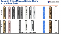
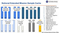
QUOTE (JRehling @ Mar 5 2021, 02:06 AM) One solution to this would be to fill about 3/4 (~24) of the sample tubes on the way up to the rim. At the top of the rim, drop ~16 of them, representing the whole trek up the delta, on the ground, and keep ~8 that also represent the trek up the delta. Then pick up ~8 more on the crater rim, and when that is complete, drop all ~16 in one spot. That leaves you with ~16 representing the delta in one place and ~16 representing both the delta and the crater rim in another place. The return can choose which group of 16 to retrieve. If there were any failure in the return, there's another group of ~16 for a second try. If Perseverance failed after reaching the crater rim, there would be the first set of ~16 for a first and only retrieval attempt. Phil Stooke at NASAspaceflight.com posted links to presentations from a recent sampling strategy workshop. Extremely interesting with lots of details on the notional traverses, notional sampling plan, and notional caching strategy Link to Phil's post First set of slides Second set of slides Third set of slides These slides are from those presentations and represent a notional sampling strategy.
Attached thumbnail(s)
-------------------- |
||
|
|
|
||
|
Mar 5 2021, 06:59 PM
Post
#7
|
|
|
Member Group: Members Posts: 248 Joined: 25-February 21 From: Waltham, Massachussetts, U.S.A. Member No.: 8974 |
QUOTE (vjkane @ Mar 5 2021, 09:23 AM) Phil Stooke at NASAspaceflight.com posted links to presentations from a recent sampling strategy workshop. Extremely interesting with lots of details on the notional traverses, notional sampling plan, and notional caching strategy Link to Phil's post First set of slides Second set of slides Third set of slides These slides are from those presentations and represent a notional sampling strategy. Thanks, these slides provide a good summary of what I take is the current understanding of the crater and surroundings in terms of geology, traversability, and relevance to mission goals. It was the first time for me to delve a bit deeper into these planning steps. I have to say, it was surprising to me how much emphasis there is on getting out of the crater even given that it is clearly stated that the delta and the crater lake basin are the primary target. Why not really focus on that primary target ? I understand that the more diverse geology outside of the crater (Nili Planum) is tempting and that it could be explored but the criteria for not leaving the crater is either serious rover dysfunction or extremely exciting discoveries on the way (what ? a fossil ?). That leaves room for only one traversal up and along the delta. In effect, it gives the delta and crater interior the same weight as Nili Planum which does not sit quite right. So I think it will be important to make this one delta traverse count perhaps by attempting to cover all sides of the (remaining) delta. One could even argue one should stay in the delta until there is a sense of exciting discoveries, and only then leave, rather than leaving by default. Another impression I had that there is rather high confidence that it is possible to plan a detailed traverse based on current remote sensing data. My very limited experience looking in detail at HiRISE imagery around the landing site (and even EDL imagery) and comparing it with rover imaging on the ground would make me much less confident to do such planning much in advance. The rover is only 3m or so, eg. a few pixels in these images. In other words, it will be critical to use on the ground imagery as it becomes available, with a willingness to revise existing plans freely. This seems perhaps obvious but with all the planning investment there may be a degree of inertia. Considering this, I think there should be a lot of, almost exclusive emphasis on getting to and sampling the sediments about which we can know with a high degree of confidence that (a lot of) water was present. Apart from the potential for life, their composition is an indirect sample of the watershed area (at the time) which often leads to strong conclusions about geologic evolution. Imagine finding a conglomerate bed. The clasts could be dated. -------------------- --
Andreas Plesch, andreasplesch at gmail dot com |
|
|
|
|
Mar 6 2021, 12:56 AM
Post
#8
|
|
|
Member Group: Members Posts: 706 Joined: 22-April 05 Member No.: 351 |
QUOTE (Andreas Plesch @ Mar 5 2021, 10:59 AM) Thanks, these slides provide a good summary of what I take is the current understanding of the crater and surroundings in terms of geology, traversability, and relevance to mission goals. It was the first time for me to delve a bit deeper into these planning steps. I have to say, it was surprising to me how much emphasis there is on getting out of the crater even given that it is clearly stated that the delta and the crater lake basin are the primary target. Why not really focus on that primary target? ... Another impression I had that there is rather high confidence that it is possible to plan a detailed traverse based on current remote sensing data. My very limited experience looking in detail at HiRISE imagery around the landing site (and even EDL imagery) and comparing it with rover imaging on the ground would make me much less confident to do such planning much in advance. The rover is only 3m or so, eg. a few pixels in these images. In other words, it will be critical to use on the ground imagery as it becomes available, with a willingness to revise existing plans freely. This seems perhaps obvious but with all the planning investment there may be a degree of inertia. Considering this, I think there should be a lot of, almost exclusive emphasis on getting to and sampling the sediments about which we can know with a high degree of confidence that (a lot of) water was present. Apart from the potential for life, their composition is an indirect sample of the watershed area (at the time) which often leads to strong conclusions about geologic evolution. Imagine finding a conglomerate bed. The clasts could be dated. From presentations I watched several years ago, the focus was always to get a good sample of Jezero from the crater floor to rim in the primary mission lasting one Martian year. Any extended mission is gravy. A couple of thoughts on why to leave. The Great Cosmic God smiled on us and the top two places to sample Mars (as selected through a series of workshops bringing in much of the Mars science community) happen to be within driving distance. As I recall, Jezero won the vote of the workshop participants, but not by much. Not only does Midway likely contain a geologic record of key events, several of the proposed sampling sites could be locations of significant astrobiological interest. The science community *really* wants sample from both areas. As for planning the traverse, I have experience with similar products to what I expect the mission planners have. From stereo HiRISE imaging, they likely have a highly accurate 1 m (or slightly better) digital terrain model. They also can tell a great deal about the likely surface of each location from both direct photo interpretation and from texture analysis of variance among adjacent pixels. They have been using these products to plan Curiosity's traverse for years now. -------------------- |
|
|
|
|
Mar 6 2021, 02:01 AM
Post
#9
|
|
|
Member Group: Members Posts: 248 Joined: 25-February 21 From: Waltham, Massachussetts, U.S.A. Member No.: 8974 |
QUOTE (vjkane @ Mar 5 2021, 07:56 PM) From presentations I watched several years ago, the focus was always to get a good sample of Jezero from the crater floor to rim in the primary mission lasting one Martian year. Any extended mission is gravy. A couple of thoughts on why to leave. The Great Cosmic God smiled on us and the top two places to sample Mars (as selected through a series of workshops bringing in much of the Mars science community) happen to be within driving distance. As I recall, Jezero won the vote of the workshop participants, but not by much. Not only does Midway likely contain a geologic record of key events, several of the proposed sampling sites could be locations of significant astrobiological interest. The science community *really* wants sample from both areas. As for planning the traverse, I have experience with similar products to what I expect the mission planners have. From stereo HiRISE imaging, they likely have a highly accurate 1 m (or slightly better) digital terrain model. They also can tell a great deal about the likely surface of each location from both direct photo interpretation and from texture analysis of variance among adjacent pixels. They have been using these products to plan Curiosity's traverse for years now. Thanks for the background. Concerning the planning products, of course they are very valuable for considering all options. I was just impressed how every twist and turn was shown on some of planning maps. Now, the map presented today seems to go out of the crater on another route, eg. straight through the main inlet, for now. Looking at the slides, I did start to think that there are probably strong factions in the community for both the Delta and also Midland. In that case the planning discussion material makes more sense. Thinking ahead it is somewhat problematic that the expected lifetime (1-2 years) of the mission is so conservative, in light of the success of previous missions. It will be impossible to argue to go back into the crater once the rover left it. -------------------- --
Andreas Plesch, andreasplesch at gmail dot com |
|
|
|
 nprev The Geology of Jezero Crater Feb 24 2021, 01:41 AM
 Pando While these "holey" rocks appear light i... Feb 27 2021, 07:30 PM Blue Sky If the crater floor is covered by ash or other vol... Feb 27 2021, 07:39 PM
 JRehling It's virtually certain that some of the materi... Feb 27 2021, 09:20 PM
 MahFL QUOTE (Blue Sky @ Feb 27 2021, 07:39 PM) ... Feb 28 2021, 06:39 AM Andreas Plesch Yes, these lineations may have formed from aeolian... Feb 28 2021, 02:08 AM JRehling Great look at the layering in the outlier, Andreas... Feb 28 2021, 02:42 AM Andreas Plesch QUOTE (JRehling @ Feb 27 2021, 09:42 PM) ... Feb 28 2021, 04:14 AM serpens QUOTE (Andreas Plesch @ Feb 28 2021, 04:1... Feb 28 2021, 10:42 PM Andreas Plesch QUOTE (serpens @ Feb 28 2021, 05:42 PM) T... Mar 1 2021, 07:21 PM Marz this is a high-level description of the regional g... Feb 28 2021, 09:42 PM HSchirmer QUOTE (Marz @ Feb 28 2021, 09:42 PM) this... Feb 28 2021, 10:58 PM SulliedGoon If caves created by ancient running waters
existed... Mar 1 2021, 03:23 AM HSchirmer Hat tip to serpens for finding a paper about coast... Mar 1 2021, 02:24 PM serpens Perhaps just coincidence but the pre-Tharsis high ... Mar 1 2021, 09:19 PM MarkL A couple of things interest me here (inset of ESP_... Mar 3 2021, 06:56 PM atomoid That seeming volcanic cone is quite distinct and i... Mar 4 2021, 01:08 AM HSchirmer QUOTE (atomoid @ Mar 4 2021, 01:08 AM) He... Mar 4 2021, 04:36 PM atomoid ...That large image size is giving my eye-crossing... Mar 4 2021, 10:10 PM serpens The cones are the product of aeolian erosion. The... Mar 4 2021, 01:53 AM MarkL QUOTE (serpens @ Mar 4 2021, 02:53 AM) Th... Mar 4 2021, 03:34 AM Blue Sky The canyon at lower left in the picture in post #5... Mar 4 2021, 03:54 AM MarkL Wouldn't that be one crazy vista? Imagine loo... Mar 4 2021, 04:22 AM Gladstoner A portion of a possible traverse that would examin... Mar 4 2021, 06:50 AM MahFL QUOTE (Gladstoner @ Mar 4 2021, 06:50 AM)... Mar 4 2021, 08:31 PM vjkane QUOTE (Gladstoner @ Mar 3 2021, 10:50 PM)... Mar 4 2021, 09:55 PM Gladstoner Would also like to examine some of these up close:... Mar 4 2021, 06:58 AM HSchirmer QUOTE (Gladstoner @ Mar 4 2021, 06:58 AM)... Mar 4 2021, 04:51 PM serpens QUOTE (Gladstoner @ Mar 4 2021, 06:58 AM)... Mar 8 2021, 12:39 AM HSchirmer QUOTE (serpens @ Mar 8 2021, 01:39 AM) I ... Mar 8 2021, 11:58 PM serpens vjkane, Perseverance has four primary mission obje... Mar 4 2021, 10:55 PM vjkane QUOTE (serpens @ Mar 4 2021, 02:55 PM) vj... Mar 5 2021, 12:24 AM serpens I thought the revised schedule was for launch of t... Mar 5 2021, 12:47 AM vjkane QUOTE (serpens @ Mar 4 2021, 04:47 PM) I ... Mar 5 2021, 02:04 AM JRehling Thanks for the full background, Van.
It was this ... Mar 5 2021, 04:23 PM JRehling I share the subjective feeling that Andreas indica... Mar 5 2021, 08:44 PM vjkane QUOTE (Andreas Plesch @ Mar 5 2021, 06:01... Mar 6 2021, 02:02 PM HSchirmer RE: The Geology of Jezero Crater Mar 5 2021, 12:08 PM HSchirmer QUOTE (vjkane @ Mar 5 2021, 05:28 AM) If ... Mar 5 2021, 12:12 PM serpens I suspect that as with Curiosity there will be sig... Mar 5 2021, 11:04 PM HSchirmer I found the timeline for Jezro in the press packag... Mar 6 2021, 03:13 PM tdemko Im not sure the emphasis is on the pre-lake depos... Mar 6 2021, 10:59 PM JRehling Good information, tdemko.
In this case, it seems ... Mar 7 2021, 12:29 AM nprev Should I just change the name of this thread to ... Mar 7 2021, 11:31 AM tdemko Not sure if the question about experimental basin ... Mar 8 2021, 02:04 PM Andreas Plesch The source of the sediments in the delta
The (mai... Mar 8 2021, 09:02 PM JRehling With both respect and gratitude for the expertise ... Mar 9 2021, 12:27 AM tdemko QUOTE (JRehling @ Mar 8 2021, 07:27 PM) W... Mar 9 2021, 02:43 AM serpens Andreas, despite erosion there are obvious remnant... Mar 9 2021, 01:17 AM Andreas Plesch There are sedimentologists specializing in landsca... Mar 9 2021, 02:29 AM serpens QUOTE (Andreas Plesch @ Mar 9 2021, 03:29... Mar 9 2021, 02:36 PM Andreas Plesch QUOTE (serpens @ Mar 9 2021, 09:36 AM) Wh... Mar 9 2021, 03:08 PM HSchirmer QUOTE (serpens @ Mar 9 2021, 02:36 PM) Wh... Mar 9 2021, 03:30 PM Andreas Plesch I find myself agreeing with much of what the abstr... Mar 9 2021, 02:54 AM MarkL Do we have any insight as to why the small deltaic... Mar 9 2021, 10:20 AM MahFL QUOTE (MarkL @ Mar 9 2021, 10:20 AM) Do w... Mar 9 2021, 11:22 AM HSchirmer QUOTE Do we have any insight as to why the small d... Mar 9 2021, 12:14 PM HSchirmer Not sure where to post this- so, try the 'hot... Mar 10 2021, 10:27 AM fredk QUOTE (HSchirmer @ Mar 10 2021, 11:27 AM)... Mar 11 2021, 12:40 AM JRehling Martian dust is not representative of martian rock... Mar 15 2021, 12:40 AM Marz nice to see preliminary results already!
... Mar 14 2021, 09:43 PM pbanholzer [quote name='Marz' date='Mar 14 2021, ... Mar 15 2021, 05:08 AM Andreas Plesch QUOTE (pbanholzer @ Mar 15 2021, 01:08 AM... Mar 15 2021, 02:47 PM serpens Currently the primary source of dust is the Medusa... Mar 15 2021, 03:46 AM serpens While the channels leading into Jezero, the delta ... Mar 16 2021, 07:26 AM Blue Sky Looks like width of the channel is about half a ki... Mar 16 2021, 08:02 PM Andreas Plesch I am following https://twitter.com/hashtag/LPSC202... Mar 16 2021, 08:22 PM Phil Stooke HSchirmer: "500 MY old fossils of the same fi... Mar 16 2021, 09:08 PM HSchirmer QUOTE (Phil Stooke @ Mar 16 2021, 10:08 P... Mar 16 2021, 11:27 PM Marz one interesting tidbit in this summary is that som... Mar 16 2021, 11:11 PM pioneer I've read some articles such as this one talki... Mar 16 2021, 11:30 PM JRehling QUOTE (pioneer @ Mar 16 2021, 04:30 PM) I... Mar 17 2021, 03:14 AM JRehling On the East Coast of the U.S., the Susquehanna is ... Mar 17 2021, 03:22 AM HSchirmer QUOTE (JRehling @ Mar 17 2021, 03:14 AM) ... Mar 17 2021, 03:26 AM Andreas Plesch A few essential ages: The Atlantic Ocean started t... Mar 17 2021, 12:52 AM HSchirmer QUOTE (Andreas Plesch @ Mar 17 2021, 12:5... Mar 17 2021, 01:02 AM Andreas Plesch Good point. I thought I saw today in summary blog ... Mar 17 2021, 01:12 AM serpens Could you expand on that please Andreas as I would... Mar 17 2021, 03:21 AM Andreas Plesch QUOTE (serpens @ Mar 16 2021, 10:21 PM) C... Mar 17 2021, 04:41 AM serpens The key question with respect to the Jezero region... Mar 17 2021, 04:47 AM JRehling This is good reading. It places some constraints o... Mar 17 2021, 05:37 AM HSchirmer QUOTE (serpens @ Mar 17 2021, 05:47 AM) t... Mar 17 2021, 03:31 PM serpens Andreas, I had read the Quantin-Nataf et al paper ... Mar 17 2021, 06:43 AM JRehling QUOTE (serpens @ Mar 16 2021, 11:43 PM) J... Mar 18 2021, 05:06 AM Andreas Plesch A few figures for future reference showing some in... Mar 17 2021, 03:14 PM serpens Andreas, While I am sure most here are around the ... Mar 18 2021, 12:48 AM serpens Early Mars would have been a pretty dynamic place,... Mar 18 2021, 11:55 PM
MahFL QUOTE (Blue Sky @ Feb 27 2021, 07:39 PM) ... Feb 28 2021, 06:39 AM Andreas Plesch Yes, these lineations may have formed from aeolian... Feb 28 2021, 02:08 AM JRehling Great look at the layering in the outlier, Andreas... Feb 28 2021, 02:42 AM Andreas Plesch QUOTE (JRehling @ Feb 27 2021, 09:42 PM) ... Feb 28 2021, 04:14 AM serpens QUOTE (Andreas Plesch @ Feb 28 2021, 04:1... Feb 28 2021, 10:42 PM Andreas Plesch QUOTE (serpens @ Feb 28 2021, 05:42 PM) T... Mar 1 2021, 07:21 PM Marz this is a high-level description of the regional g... Feb 28 2021, 09:42 PM HSchirmer QUOTE (Marz @ Feb 28 2021, 09:42 PM) this... Feb 28 2021, 10:58 PM SulliedGoon If caves created by ancient running waters
existed... Mar 1 2021, 03:23 AM HSchirmer Hat tip to serpens for finding a paper about coast... Mar 1 2021, 02:24 PM serpens Perhaps just coincidence but the pre-Tharsis high ... Mar 1 2021, 09:19 PM MarkL A couple of things interest me here (inset of ESP_... Mar 3 2021, 06:56 PM atomoid That seeming volcanic cone is quite distinct and i... Mar 4 2021, 01:08 AM HSchirmer QUOTE (atomoid @ Mar 4 2021, 01:08 AM) He... Mar 4 2021, 04:36 PM atomoid ...That large image size is giving my eye-crossing... Mar 4 2021, 10:10 PM serpens The cones are the product of aeolian erosion. The... Mar 4 2021, 01:53 AM MarkL QUOTE (serpens @ Mar 4 2021, 02:53 AM) Th... Mar 4 2021, 03:34 AM Blue Sky The canyon at lower left in the picture in post #5... Mar 4 2021, 03:54 AM MarkL Wouldn't that be one crazy vista? Imagine loo... Mar 4 2021, 04:22 AM Gladstoner A portion of a possible traverse that would examin... Mar 4 2021, 06:50 AM MahFL QUOTE (Gladstoner @ Mar 4 2021, 06:50 AM)... Mar 4 2021, 08:31 PM vjkane QUOTE (Gladstoner @ Mar 3 2021, 10:50 PM)... Mar 4 2021, 09:55 PM Gladstoner Would also like to examine some of these up close:... Mar 4 2021, 06:58 AM HSchirmer QUOTE (Gladstoner @ Mar 4 2021, 06:58 AM)... Mar 4 2021, 04:51 PM serpens QUOTE (Gladstoner @ Mar 4 2021, 06:58 AM)... Mar 8 2021, 12:39 AM HSchirmer QUOTE (serpens @ Mar 8 2021, 01:39 AM) I ... Mar 8 2021, 11:58 PM serpens vjkane, Perseverance has four primary mission obje... Mar 4 2021, 10:55 PM vjkane QUOTE (serpens @ Mar 4 2021, 02:55 PM) vj... Mar 5 2021, 12:24 AM serpens I thought the revised schedule was for launch of t... Mar 5 2021, 12:47 AM vjkane QUOTE (serpens @ Mar 4 2021, 04:47 PM) I ... Mar 5 2021, 02:04 AM JRehling Thanks for the full background, Van.
It was this ... Mar 5 2021, 04:23 PM JRehling I share the subjective feeling that Andreas indica... Mar 5 2021, 08:44 PM vjkane QUOTE (Andreas Plesch @ Mar 5 2021, 06:01... Mar 6 2021, 02:02 PM HSchirmer RE: The Geology of Jezero Crater Mar 5 2021, 12:08 PM HSchirmer QUOTE (vjkane @ Mar 5 2021, 05:28 AM) If ... Mar 5 2021, 12:12 PM serpens I suspect that as with Curiosity there will be sig... Mar 5 2021, 11:04 PM HSchirmer I found the timeline for Jezro in the press packag... Mar 6 2021, 03:13 PM tdemko Im not sure the emphasis is on the pre-lake depos... Mar 6 2021, 10:59 PM JRehling Good information, tdemko.
In this case, it seems ... Mar 7 2021, 12:29 AM nprev Should I just change the name of this thread to ... Mar 7 2021, 11:31 AM tdemko Not sure if the question about experimental basin ... Mar 8 2021, 02:04 PM Andreas Plesch The source of the sediments in the delta
The (mai... Mar 8 2021, 09:02 PM JRehling With both respect and gratitude for the expertise ... Mar 9 2021, 12:27 AM tdemko QUOTE (JRehling @ Mar 8 2021, 07:27 PM) W... Mar 9 2021, 02:43 AM serpens Andreas, despite erosion there are obvious remnant... Mar 9 2021, 01:17 AM Andreas Plesch There are sedimentologists specializing in landsca... Mar 9 2021, 02:29 AM serpens QUOTE (Andreas Plesch @ Mar 9 2021, 03:29... Mar 9 2021, 02:36 PM Andreas Plesch QUOTE (serpens @ Mar 9 2021, 09:36 AM) Wh... Mar 9 2021, 03:08 PM HSchirmer QUOTE (serpens @ Mar 9 2021, 02:36 PM) Wh... Mar 9 2021, 03:30 PM Andreas Plesch I find myself agreeing with much of what the abstr... Mar 9 2021, 02:54 AM MarkL Do we have any insight as to why the small deltaic... Mar 9 2021, 10:20 AM MahFL QUOTE (MarkL @ Mar 9 2021, 10:20 AM) Do w... Mar 9 2021, 11:22 AM HSchirmer QUOTE Do we have any insight as to why the small d... Mar 9 2021, 12:14 PM HSchirmer Not sure where to post this- so, try the 'hot... Mar 10 2021, 10:27 AM fredk QUOTE (HSchirmer @ Mar 10 2021, 11:27 AM)... Mar 11 2021, 12:40 AM JRehling Martian dust is not representative of martian rock... Mar 15 2021, 12:40 AM Marz nice to see preliminary results already!
... Mar 14 2021, 09:43 PM pbanholzer [quote name='Marz' date='Mar 14 2021, ... Mar 15 2021, 05:08 AM Andreas Plesch QUOTE (pbanholzer @ Mar 15 2021, 01:08 AM... Mar 15 2021, 02:47 PM serpens Currently the primary source of dust is the Medusa... Mar 15 2021, 03:46 AM serpens While the channels leading into Jezero, the delta ... Mar 16 2021, 07:26 AM Blue Sky Looks like width of the channel is about half a ki... Mar 16 2021, 08:02 PM Andreas Plesch I am following https://twitter.com/hashtag/LPSC202... Mar 16 2021, 08:22 PM Phil Stooke HSchirmer: "500 MY old fossils of the same fi... Mar 16 2021, 09:08 PM HSchirmer QUOTE (Phil Stooke @ Mar 16 2021, 10:08 P... Mar 16 2021, 11:27 PM Marz one interesting tidbit in this summary is that som... Mar 16 2021, 11:11 PM pioneer I've read some articles such as this one talki... Mar 16 2021, 11:30 PM JRehling QUOTE (pioneer @ Mar 16 2021, 04:30 PM) I... Mar 17 2021, 03:14 AM JRehling On the East Coast of the U.S., the Susquehanna is ... Mar 17 2021, 03:22 AM HSchirmer QUOTE (JRehling @ Mar 17 2021, 03:14 AM) ... Mar 17 2021, 03:26 AM Andreas Plesch A few essential ages: The Atlantic Ocean started t... Mar 17 2021, 12:52 AM HSchirmer QUOTE (Andreas Plesch @ Mar 17 2021, 12:5... Mar 17 2021, 01:02 AM Andreas Plesch Good point. I thought I saw today in summary blog ... Mar 17 2021, 01:12 AM serpens Could you expand on that please Andreas as I would... Mar 17 2021, 03:21 AM Andreas Plesch QUOTE (serpens @ Mar 16 2021, 10:21 PM) C... Mar 17 2021, 04:41 AM serpens The key question with respect to the Jezero region... Mar 17 2021, 04:47 AM JRehling This is good reading. It places some constraints o... Mar 17 2021, 05:37 AM HSchirmer QUOTE (serpens @ Mar 17 2021, 05:47 AM) t... Mar 17 2021, 03:31 PM serpens Andreas, I had read the Quantin-Nataf et al paper ... Mar 17 2021, 06:43 AM JRehling QUOTE (serpens @ Mar 16 2021, 11:43 PM) J... Mar 18 2021, 05:06 AM Andreas Plesch A few figures for future reference showing some in... Mar 17 2021, 03:14 PM serpens Andreas, While I am sure most here are around the ... Mar 18 2021, 12:48 AM serpens Early Mars would have been a pretty dynamic place,... Mar 18 2021, 11:55 PM |

|
Lo-Fi Version | Time is now: 6th June 2024 - 12:32 AM |
|
RULES AND GUIDELINES Please read the Forum Rules and Guidelines before posting. IMAGE COPYRIGHT |
OPINIONS AND MODERATION Opinions expressed on UnmannedSpaceflight.com are those of the individual posters and do not necessarily reflect the opinions of UnmannedSpaceflight.com or The Planetary Society. The all-volunteer UnmannedSpaceflight.com moderation team is wholly independent of The Planetary Society. The Planetary Society has no influence over decisions made by the UnmannedSpaceflight.com moderators. |
SUPPORT THE FORUM Unmannedspaceflight.com is funded by the Planetary Society. Please consider supporting our work and many other projects by donating to the Society or becoming a member. |
|