The Geology of Jezero Crater, Observations & Findings |

The Geology of Jezero Crater, Observations & Findings |
 Feb 24 2021, 01:41 AM Feb 24 2021, 01:41 AM
Post
#1
|
|
|
Merciless Robot  Group: Admin Posts: 8784 Joined: 8-December 05 From: Los Angeles Member No.: 602 |
This thread is for those rockhounds among us to discuss the new terrain we'll see as Perseverance scoots around her new home. Let's get dirty & technical!

-------------------- A few will take this knowledge and use this power of a dream realized as a force for change, an impetus for further discovery to make less ancient dreams real.
|
 |
 
|
 |
|
Mar 9 2021, 02:29 AM
Post
#2
|
|
|
Member Group: Members Posts: 248 Joined: 25-February 21 From: Waltham, Massachussetts, U.S.A. Member No.: 8974 |
There are sedimentologists specializing in landscape evolution and numerical modeling, see for example https://agupubs.onlinelibrary.wiley.com/doi...1002/jgrf.20031 . Consequently, there are a large number of models, based on diffusion or advection concepts. Unfortunately, I am not such a modeler and do not have that insight. My inclination would be to treat lower gravity similar to a change in slope both acting on the erosional effect at the river base in similar ways. Slope is just one parameter besides flow rate, sediment load or potentially tectonic uplift or subsidence.
With that in mind I would expect that 0.38g would require a much steeper slope for a stream to develop similar erosional characteristics, other parameters being equal (which would be difficult to establish). The 2km relief over 100km intuitively feels rather steep and it should be possible to find longitudinal river profiles of similar length, for a direct comparison. A main difference is that the profile does not look like a textbook river profile on earth which has a steep initial gradient, an intermediate section, and a very gentle final gradient before entering a base line (a lake or ocean) which is considered an equilibrium profile where erosion at the source and aggradation at the sink are in balance. I suspect that there have been attempts to understand such profiles on Mars, after the idea of an early wet history was getting (more?) widely accepted. Looking more closely along the stream, there are what could be rather short tributaries, and perhaps drainage from the Hargraves crater region to the north. Proposing a secondary inlet at the northern crater rim clearly requires some interpretation since it would be not very well preserved. I do think there are markers of channeling and meandering further upstream which seem to connect to it. [edit] ah Thanks serpens, yes that is what I see as well. It is just not much of a system of tributaries. -------------------- --
Andreas Plesch, andreasplesch at gmail dot com |
|
|
|
|
Mar 9 2021, 02:36 PM
Post
#3
|
|
|
Senior Member Group: Members Posts: 1044 Joined: 17-February 09 Member No.: 4605 |
QUOTE (Andreas Plesch @ Mar 9 2021, 03:29 AM)  ....It is just not much of a system of tributaries. While the catchment as it stands can be reasonably constrained, as HSchirmer alludes to the area has been subject to tectonic activity, cratering and erosion that makes the accurate assessment of the ancient drainage area and tributary flows challenging to say the least. While there are traces of the tributaries much has been erased. As I understand it the mineralogy of the Northern and Southern deltas vary, reflecting the mineralogy of the two separate catchment areas. All in all it is a pretty impressive drainage area which I suspect would have hosted an extensive tributary network. |
|
|
|
|
Mar 9 2021, 03:30 PM
Post
#4
|
||
 Member Group: Members Posts: 684 Joined: 24-July 15 Member No.: 7619 |
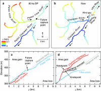
QUOTE (serpens @ Mar 9 2021, 02:36 PM) While the catchment as it stands can be reasonably constrained, as HSchirmer alludes to the area has been subject to tectonic activity, cratering and erosion that makes the accurate assessment of the ancient drainage area and tributary flows challenging to say the least. A follow up point - when tectonics tilts an entire river drainage network on 50, 200, 500, 1,000 km scale, you get paradoxes: Example is the geology / biodiversity paradox for the US east coast: 500 MY old fish populations in 200 MY old rivers. The main US coastal rivers: Hudson, Delaware, Susquehanna, Potomac, Cape Fear, Congaree & Savannah all run east from the Allegheny mountains to the Atlantic ocean. The Atlantic ocean opened up ~200 million years ago when Pangea broke up. However, 500 MY old fossils of the same fish species that are in the river now indicates the rivers are over 500 million years old. At first glance would requires the east coast rivers to run UP HILL towards the central "Himalayan plateau" of Pangea. The solution is that the river tributaries are older than the river & ocean they currently drain to, the large main stems have reversed course. All the large east coast rivers USED to be small header tributaries that drained west to the proto-Mississippi. Once the Atlantic opened, they had a steeper gradient heading east, which allowed quick erosion to gorges, which cut back to the west and captured more and more feeder rivers and streams, which accelerated erosion... https://www.researchgate.net/figure/River-n..._fig1_327653964 Conversely, as the old western-draining network lost tributaries, reduced flow leads to silting up, which slows flow, dropping even more sediment: you get a series of lakes & wetlands, rising water levels, and eventually the water level over-tops the watershed divide and begins flowing east to the Atlantic instead of west to the Mississippi. Repeat that process a few times for Jezro, add in 2 possible ocean shorelines, and you've got an idea of the scope of the question!
Attached thumbnail(s)
|
|
|
|
|
|
 nprev The Geology of Jezero Crater Feb 24 2021, 01:41 AM
 HSchirmer QUOTE (nprev @ Feb 24 2021, 02:41 AM) Thi... Feb 24 2021, 01:51 AM dougkeenan Is it indeed "Geology" and not "Are... Feb 24 2021, 02:13 AM
 HSchirmer QUOTE (dougkeenan @ Feb 24 2021, 03:13 AM... Feb 24 2021, 02:31 AM Phil Stooke This has been a discussion since the 1960s. I rem... Feb 24 2021, 02:52 AM HSchirmer QUOTE (Phil Stooke @ Feb 24 2021, 03:52 A... Feb 24 2021, 03:32 AM Pando QUOTE (HSchirmer @ Feb 23 2021, 07:32 PM)... Feb 24 2021, 04:41 AM Don1 Some resources:
A recent USGS geological map of t... Feb 24 2021, 03:11 AM Eutectic QUOTE (Don1 @ Feb 23 2021, 09:11 PM) Some... Feb 24 2021, 09:48 AM JRehling For now, we have a mission that'll be explorin... Feb 24 2021, 05:00 PM HSchirmer QUOTE (JRehling @ Feb 24 2021, 05:00 PM) ... Feb 24 2021, 08:06 PM JRehling What we see now in the near distance is not though... Feb 24 2021, 09:55 PM HSchirmer QUOTE (JRehling @ Feb 24 2021, 09:55 PM) ... Feb 25 2021, 12:48 AM stevesliva Because this forum is now old enough to drive, the... Feb 24 2021, 04:32 AM nprev ....aaaand, were done with the pedantry.
Let... Feb 24 2021, 07:16 AM serpens QUOTE (nprev @ Feb 24 2021, 07:16 AM) ...... Feb 24 2021, 07:34 AM serpens The consensus seems to be that the crater floor wa... Feb 25 2021, 02:16 AM JRehling One detail in the Sol 3 panorama that's especi... Feb 25 2021, 04:29 PM HSchirmer QUOTE (JRehling @ Feb 25 2021, 04:29 PM) ... Feb 25 2021, 06:15 PM Andreas Plesch Delta erosion
At distances of a few hundered mete... Feb 26 2021, 09:44 PM HSchirmer QUOTE (Andreas Plesch @ Feb 26 2021, 10:4... Feb 26 2021, 11:37 PM serpens Good post Andreas. The isolated hills have been n... Feb 27 2021, 12:00 AM HSchirmer QUOTE (serpens @ Feb 27 2021, 12:00 AM) I... Feb 27 2021, 12:41 AM Andreas Plesch QUOTE (HSchirmer @ Feb 26 2021, 07:41 PM)... Feb 27 2021, 02:20 AM serpens The possibility that the mafic floor unit is sedim... Feb 27 2021, 03:28 AM HSchirmer QUOTE (serpens @ Feb 27 2021, 03:28 AM) T... Feb 27 2021, 01:33 PM serpens QUOTE (HSchirmer @ Feb 27 2021, 01:33 PM)... Feb 27 2021, 11:47 PM pioneer Does anyone know which rock Perseverance will exam... Feb 27 2021, 04:47 PM Phil Stooke No news on that yet. Things are just ramping up a... Feb 27 2021, 05:22 PM Marz
This image was cropped from the mastcam-z pan. ... Feb 27 2021, 05:38 PM Andreas Plesch QUOTE (Marz @ Feb 27 2021, 12:38 PM)
Th... Feb 27 2021, 07:24 PM Marz QUOTE (Andreas Plesch @ Feb 27 2021, 02:2... Feb 27 2021, 07:33 PM Steve5304 QUOTE (Andreas Plesch @ Feb 27 2021, 08:2... Feb 28 2021, 05:11 AM JRehling Opportunity and Curiosity both found rocks that we... Feb 28 2021, 05:35 AM ElkGroveDan QUOTE (Steve5304 @ Feb 27 2021, 09:11 PM)... Mar 4 2021, 10:13 PM HSchirmer QUOTE (Marz @ Feb 27 2021, 06:38 PM) This... Feb 27 2021, 08:58 PM Pando While these "holey" rocks appear light i... Feb 27 2021, 07:30 PM Blue Sky If the crater floor is covered by ash or other vol... Feb 27 2021, 07:39 PM JRehling It's virtually certain that some of the materi... Feb 27 2021, 09:20 PM MahFL QUOTE (Blue Sky @ Feb 27 2021, 07:39 PM) ... Feb 28 2021, 06:39 AM Andreas Plesch Yes, these lineations may have formed from aeolian... Feb 28 2021, 02:08 AM JRehling Great look at the layering in the outlier, Andreas... Feb 28 2021, 02:42 AM Andreas Plesch QUOTE (JRehling @ Feb 27 2021, 09:42 PM) ... Feb 28 2021, 04:14 AM serpens QUOTE (Andreas Plesch @ Feb 28 2021, 04:1... Feb 28 2021, 10:42 PM Andreas Plesch QUOTE (serpens @ Feb 28 2021, 05:42 PM) T... Mar 1 2021, 07:21 PM Marz this is a high-level description of the regional g... Feb 28 2021, 09:42 PM HSchirmer QUOTE (Marz @ Feb 28 2021, 09:42 PM) this... Feb 28 2021, 10:58 PM SulliedGoon If caves created by ancient running waters
existed... Mar 1 2021, 03:23 AM HSchirmer Hat tip to serpens for finding a paper about coast... Mar 1 2021, 02:24 PM serpens Perhaps just coincidence but the pre-Tharsis high ... Mar 1 2021, 09:19 PM MarkL A couple of things interest me here (inset of ESP_... Mar 3 2021, 06:56 PM atomoid That seeming volcanic cone is quite distinct and i... Mar 4 2021, 01:08 AM HSchirmer QUOTE (atomoid @ Mar 4 2021, 01:08 AM) He... Mar 4 2021, 04:36 PM atomoid ...That large image size is giving my eye-crossing... Mar 4 2021, 10:10 PM serpens The cones are the product of aeolian erosion. The... Mar 4 2021, 01:53 AM MarkL QUOTE (serpens @ Mar 4 2021, 02:53 AM) Th... Mar 4 2021, 03:34 AM Blue Sky The canyon at lower left in the picture in post #5... Mar 4 2021, 03:54 AM MarkL Wouldn't that be one crazy vista? Imagine loo... Mar 4 2021, 04:22 AM Gladstoner A portion of a possible traverse that would examin... Mar 4 2021, 06:50 AM MahFL QUOTE (Gladstoner @ Mar 4 2021, 06:50 AM)... Mar 4 2021, 08:31 PM vjkane QUOTE (Gladstoner @ Mar 3 2021, 10:50 PM)... Mar 4 2021, 09:55 PM Gladstoner Would also like to examine some of these up close:... Mar 4 2021, 06:58 AM HSchirmer QUOTE (Gladstoner @ Mar 4 2021, 06:58 AM)... Mar 4 2021, 04:51 PM serpens QUOTE (Gladstoner @ Mar 4 2021, 06:58 AM)... Mar 8 2021, 12:39 AM HSchirmer QUOTE (serpens @ Mar 8 2021, 01:39 AM) I ... Mar 8 2021, 11:58 PM serpens vjkane, Perseverance has four primary mission obje... Mar 4 2021, 10:55 PM vjkane QUOTE (serpens @ Mar 4 2021, 02:55 PM) vj... Mar 5 2021, 12:24 AM serpens I thought the revised schedule was for launch of t... Mar 5 2021, 12:47 AM vjkane QUOTE (serpens @ Mar 4 2021, 04:47 PM) I ... Mar 5 2021, 02:04 AM Explorer1 One of the papers I read (can't find it now) i... Mar 5 2021, 03:45 AM vjkane QUOTE (Explorer1 @ Mar 4 2021, 07:45 PM) ... Mar 5 2021, 05:28 AM MahFL QUOTE (vjkane @ Mar 5 2021, 05:28 AM) ...... Mar 5 2021, 07:25 AM JRehling One solution to this would be to fill about 3/4 (~... Mar 5 2021, 10:06 AM vjkane QUOTE (JRehling @ Mar 5 2021, 02:06 AM) O... Mar 5 2021, 02:23 PM JRehling Thanks for the full background, Van.
It was this ... Mar 5 2021, 04:23 PM Andreas Plesch QUOTE (vjkane @ Mar 5 2021, 09:23 AM) Phi... Mar 5 2021, 06:59 PM JRehling I share the subjective feeling that Andreas indica... Mar 5 2021, 08:44 PM vjkane QUOTE (Andreas Plesch @ Mar 5 2021, 10:59... Mar 6 2021, 12:56 AM Andreas Plesch QUOTE (vjkane @ Mar 5 2021, 07:56 PM) Fro... Mar 6 2021, 02:01 AM vjkane QUOTE (Andreas Plesch @ Mar 5 2021, 06:01... Mar 6 2021, 02:02 PM HSchirmer RE: The Geology of Jezero Crater Mar 5 2021, 12:08 PM HSchirmer QUOTE (vjkane @ Mar 5 2021, 05:28 AM) If ... Mar 5 2021, 12:12 PM serpens I suspect that as with Curiosity there will be sig... Mar 5 2021, 11:04 PM HSchirmer I found the timeline for Jezro in the press packag... Mar 6 2021, 03:13 PM tdemko Im not sure the emphasis is on the pre-lake depos... Mar 6 2021, 10:59 PM JRehling Good information, tdemko.
In this case, it seems ... Mar 7 2021, 12:29 AM nprev Should I just change the name of this thread to ... Mar 7 2021, 11:31 AM tdemko Not sure if the question about experimental basin ... Mar 8 2021, 02:04 PM Andreas Plesch The source of the sediments in the delta
The (mai... Mar 8 2021, 09:02 PM JRehling With both respect and gratitude for the expertise ... Mar 9 2021, 12:27 AM tdemko QUOTE (JRehling @ Mar 8 2021, 07:27 PM) W... Mar 9 2021, 02:43 AM serpens Andreas, despite erosion there are obvious remnant... Mar 9 2021, 01:17 AM Andreas Plesch QUOTE (serpens @ Mar 9 2021, 09:36 AM) Wh... Mar 9 2021, 03:08 PM Andreas Plesch I find myself agreeing with much of what the abstr... Mar 9 2021, 02:54 AM MarkL Do we have any insight as to why the small deltaic... Mar 9 2021, 10:20 AM MahFL QUOTE (MarkL @ Mar 9 2021, 10:20 AM) Do w... Mar 9 2021, 11:22 AM HSchirmer QUOTE Do we have any insight as to why the small d... Mar 9 2021, 12:14 PM
HSchirmer QUOTE (dougkeenan @ Feb 24 2021, 03:13 AM... Feb 24 2021, 02:31 AM Phil Stooke This has been a discussion since the 1960s. I rem... Feb 24 2021, 02:52 AM HSchirmer QUOTE (Phil Stooke @ Feb 24 2021, 03:52 A... Feb 24 2021, 03:32 AM Pando QUOTE (HSchirmer @ Feb 23 2021, 07:32 PM)... Feb 24 2021, 04:41 AM Don1 Some resources:
A recent USGS geological map of t... Feb 24 2021, 03:11 AM Eutectic QUOTE (Don1 @ Feb 23 2021, 09:11 PM) Some... Feb 24 2021, 09:48 AM JRehling For now, we have a mission that'll be explorin... Feb 24 2021, 05:00 PM HSchirmer QUOTE (JRehling @ Feb 24 2021, 05:00 PM) ... Feb 24 2021, 08:06 PM JRehling What we see now in the near distance is not though... Feb 24 2021, 09:55 PM HSchirmer QUOTE (JRehling @ Feb 24 2021, 09:55 PM) ... Feb 25 2021, 12:48 AM stevesliva Because this forum is now old enough to drive, the... Feb 24 2021, 04:32 AM nprev ....aaaand, were done with the pedantry.
Let... Feb 24 2021, 07:16 AM serpens QUOTE (nprev @ Feb 24 2021, 07:16 AM) ...... Feb 24 2021, 07:34 AM serpens The consensus seems to be that the crater floor wa... Feb 25 2021, 02:16 AM JRehling One detail in the Sol 3 panorama that's especi... Feb 25 2021, 04:29 PM HSchirmer QUOTE (JRehling @ Feb 25 2021, 04:29 PM) ... Feb 25 2021, 06:15 PM Andreas Plesch Delta erosion
At distances of a few hundered mete... Feb 26 2021, 09:44 PM HSchirmer QUOTE (Andreas Plesch @ Feb 26 2021, 10:4... Feb 26 2021, 11:37 PM serpens Good post Andreas. The isolated hills have been n... Feb 27 2021, 12:00 AM HSchirmer QUOTE (serpens @ Feb 27 2021, 12:00 AM) I... Feb 27 2021, 12:41 AM Andreas Plesch QUOTE (HSchirmer @ Feb 26 2021, 07:41 PM)... Feb 27 2021, 02:20 AM serpens The possibility that the mafic floor unit is sedim... Feb 27 2021, 03:28 AM HSchirmer QUOTE (serpens @ Feb 27 2021, 03:28 AM) T... Feb 27 2021, 01:33 PM serpens QUOTE (HSchirmer @ Feb 27 2021, 01:33 PM)... Feb 27 2021, 11:47 PM pioneer Does anyone know which rock Perseverance will exam... Feb 27 2021, 04:47 PM Phil Stooke No news on that yet. Things are just ramping up a... Feb 27 2021, 05:22 PM Marz
This image was cropped from the mastcam-z pan. ... Feb 27 2021, 05:38 PM Andreas Plesch QUOTE (Marz @ Feb 27 2021, 12:38 PM)
Th... Feb 27 2021, 07:24 PM Marz QUOTE (Andreas Plesch @ Feb 27 2021, 02:2... Feb 27 2021, 07:33 PM Steve5304 QUOTE (Andreas Plesch @ Feb 27 2021, 08:2... Feb 28 2021, 05:11 AM JRehling Opportunity and Curiosity both found rocks that we... Feb 28 2021, 05:35 AM ElkGroveDan QUOTE (Steve5304 @ Feb 27 2021, 09:11 PM)... Mar 4 2021, 10:13 PM HSchirmer QUOTE (Marz @ Feb 27 2021, 06:38 PM) This... Feb 27 2021, 08:58 PM Pando While these "holey" rocks appear light i... Feb 27 2021, 07:30 PM Blue Sky If the crater floor is covered by ash or other vol... Feb 27 2021, 07:39 PM JRehling It's virtually certain that some of the materi... Feb 27 2021, 09:20 PM MahFL QUOTE (Blue Sky @ Feb 27 2021, 07:39 PM) ... Feb 28 2021, 06:39 AM Andreas Plesch Yes, these lineations may have formed from aeolian... Feb 28 2021, 02:08 AM JRehling Great look at the layering in the outlier, Andreas... Feb 28 2021, 02:42 AM Andreas Plesch QUOTE (JRehling @ Feb 27 2021, 09:42 PM) ... Feb 28 2021, 04:14 AM serpens QUOTE (Andreas Plesch @ Feb 28 2021, 04:1... Feb 28 2021, 10:42 PM Andreas Plesch QUOTE (serpens @ Feb 28 2021, 05:42 PM) T... Mar 1 2021, 07:21 PM Marz this is a high-level description of the regional g... Feb 28 2021, 09:42 PM HSchirmer QUOTE (Marz @ Feb 28 2021, 09:42 PM) this... Feb 28 2021, 10:58 PM SulliedGoon If caves created by ancient running waters
existed... Mar 1 2021, 03:23 AM HSchirmer Hat tip to serpens for finding a paper about coast... Mar 1 2021, 02:24 PM serpens Perhaps just coincidence but the pre-Tharsis high ... Mar 1 2021, 09:19 PM MarkL A couple of things interest me here (inset of ESP_... Mar 3 2021, 06:56 PM atomoid That seeming volcanic cone is quite distinct and i... Mar 4 2021, 01:08 AM HSchirmer QUOTE (atomoid @ Mar 4 2021, 01:08 AM) He... Mar 4 2021, 04:36 PM atomoid ...That large image size is giving my eye-crossing... Mar 4 2021, 10:10 PM serpens The cones are the product of aeolian erosion. The... Mar 4 2021, 01:53 AM MarkL QUOTE (serpens @ Mar 4 2021, 02:53 AM) Th... Mar 4 2021, 03:34 AM Blue Sky The canyon at lower left in the picture in post #5... Mar 4 2021, 03:54 AM MarkL Wouldn't that be one crazy vista? Imagine loo... Mar 4 2021, 04:22 AM Gladstoner A portion of a possible traverse that would examin... Mar 4 2021, 06:50 AM MahFL QUOTE (Gladstoner @ Mar 4 2021, 06:50 AM)... Mar 4 2021, 08:31 PM vjkane QUOTE (Gladstoner @ Mar 3 2021, 10:50 PM)... Mar 4 2021, 09:55 PM Gladstoner Would also like to examine some of these up close:... Mar 4 2021, 06:58 AM HSchirmer QUOTE (Gladstoner @ Mar 4 2021, 06:58 AM)... Mar 4 2021, 04:51 PM serpens QUOTE (Gladstoner @ Mar 4 2021, 06:58 AM)... Mar 8 2021, 12:39 AM HSchirmer QUOTE (serpens @ Mar 8 2021, 01:39 AM) I ... Mar 8 2021, 11:58 PM serpens vjkane, Perseverance has four primary mission obje... Mar 4 2021, 10:55 PM vjkane QUOTE (serpens @ Mar 4 2021, 02:55 PM) vj... Mar 5 2021, 12:24 AM serpens I thought the revised schedule was for launch of t... Mar 5 2021, 12:47 AM vjkane QUOTE (serpens @ Mar 4 2021, 04:47 PM) I ... Mar 5 2021, 02:04 AM Explorer1 One of the papers I read (can't find it now) i... Mar 5 2021, 03:45 AM vjkane QUOTE (Explorer1 @ Mar 4 2021, 07:45 PM) ... Mar 5 2021, 05:28 AM MahFL QUOTE (vjkane @ Mar 5 2021, 05:28 AM) ...... Mar 5 2021, 07:25 AM JRehling One solution to this would be to fill about 3/4 (~... Mar 5 2021, 10:06 AM vjkane QUOTE (JRehling @ Mar 5 2021, 02:06 AM) O... Mar 5 2021, 02:23 PM JRehling Thanks for the full background, Van.
It was this ... Mar 5 2021, 04:23 PM Andreas Plesch QUOTE (vjkane @ Mar 5 2021, 09:23 AM) Phi... Mar 5 2021, 06:59 PM JRehling I share the subjective feeling that Andreas indica... Mar 5 2021, 08:44 PM vjkane QUOTE (Andreas Plesch @ Mar 5 2021, 10:59... Mar 6 2021, 12:56 AM Andreas Plesch QUOTE (vjkane @ Mar 5 2021, 07:56 PM) Fro... Mar 6 2021, 02:01 AM vjkane QUOTE (Andreas Plesch @ Mar 5 2021, 06:01... Mar 6 2021, 02:02 PM HSchirmer RE: The Geology of Jezero Crater Mar 5 2021, 12:08 PM HSchirmer QUOTE (vjkane @ Mar 5 2021, 05:28 AM) If ... Mar 5 2021, 12:12 PM serpens I suspect that as with Curiosity there will be sig... Mar 5 2021, 11:04 PM HSchirmer I found the timeline for Jezro in the press packag... Mar 6 2021, 03:13 PM tdemko Im not sure the emphasis is on the pre-lake depos... Mar 6 2021, 10:59 PM JRehling Good information, tdemko.
In this case, it seems ... Mar 7 2021, 12:29 AM nprev Should I just change the name of this thread to ... Mar 7 2021, 11:31 AM tdemko Not sure if the question about experimental basin ... Mar 8 2021, 02:04 PM Andreas Plesch The source of the sediments in the delta
The (mai... Mar 8 2021, 09:02 PM JRehling With both respect and gratitude for the expertise ... Mar 9 2021, 12:27 AM tdemko QUOTE (JRehling @ Mar 8 2021, 07:27 PM) W... Mar 9 2021, 02:43 AM serpens Andreas, despite erosion there are obvious remnant... Mar 9 2021, 01:17 AM Andreas Plesch QUOTE (serpens @ Mar 9 2021, 09:36 AM) Wh... Mar 9 2021, 03:08 PM Andreas Plesch I find myself agreeing with much of what the abstr... Mar 9 2021, 02:54 AM MarkL Do we have any insight as to why the small deltaic... Mar 9 2021, 10:20 AM MahFL QUOTE (MarkL @ Mar 9 2021, 10:20 AM) Do w... Mar 9 2021, 11:22 AM HSchirmer QUOTE Do we have any insight as to why the small d... Mar 9 2021, 12:14 PM |

|
Lo-Fi Version | Time is now: 1st June 2024 - 05:08 AM |
|
RULES AND GUIDELINES Please read the Forum Rules and Guidelines before posting. IMAGE COPYRIGHT |
OPINIONS AND MODERATION Opinions expressed on UnmannedSpaceflight.com are those of the individual posters and do not necessarily reflect the opinions of UnmannedSpaceflight.com or The Planetary Society. The all-volunteer UnmannedSpaceflight.com moderation team is wholly independent of The Planetary Society. The Planetary Society has no influence over decisions made by the UnmannedSpaceflight.com moderators. |
SUPPORT THE FORUM Unmannedspaceflight.com is funded by the Planetary Society. Please consider supporting our work and many other projects by donating to the Society or becoming a member. |
|