Perseverance Route Map |

Perseverance Route Map |
 Feb 22 2021, 10:16 PM Feb 22 2021, 10:16 PM
Post
#1
|
||
|
Solar System Cartographer  Group: Members Posts: 10194 Joined: 5-April 05 From: Canada Member No.: 227 |
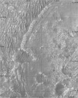
Now we are down safely I am starting a map thread. Everything that happens during 2021 will be covered in my still-in-progress atlas, so I have to make the maps for that and everyone can follow as they evolve.
Let me know if any feature names start to show up. Preliminary map even though not much has happened yet. But if you look closely you will see something, even now. Phil
-------------------- ... because the Solar System ain't gonna map itself.
Also to be found posting similar content on https://mastodon.social/@PhilStooke Maps for download (free PD: https://upload.wikimedia.org/wikipedia/comm...Cartography.pdf NOTE: everything created by me which I post on UMSF is considered to be in the public domain (NOT CC, public domain) |
|
 |
 
|
|
 |
|
Mar 10 2021, 10:34 PM
Post
#2
|
|||
|
Junior Member Group: Members Posts: 31 Joined: 10-August 12 Member No.: 6526 |
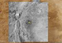
For those of you who might want to navigate this trip with Google Mars/Earth, as well, I've prepared some overlays using the large basemaps created by the USGS that were mentioned earlier in this thread.
The overview map is 5322x5040 with 6m/pixel resolution:
The larger 6.9GB map was broken into manageable 4000x4000 tiles with 0.25m/pixel resolution:
You can see some overlays of the various HiRISE and rover downcam images. For the rover track, I cobbled together a script that scrapes the "Where is Perseverance?" web page. Right now I have to run the script manually, but plan to automate it once I can make it more robust. You can download a zip file (55MB) with everything or download files individually at the site. Additional map tiles will be added to the site soon to accommodate the planned route. The elevation data currently used by GE is low resolution, so only the largest features like the crater rim render well with everything else looking kind of flat. One thing I like about GE is that it provides an easy way to geolocate the interesting images presented in this forum for future reference. Mark |
||
|
|
|
||
 Phil Stooke Perseverance Route Map Feb 22 2021, 10:16 PM
 kenny Lovely stuff, Phil.
Are we seeing evidence of the ... Feb 23 2021, 09:11 AM
kenny Lovely stuff, Phil.
Are we seeing evidence of the ... Feb 23 2021, 09:11 AM
 Marz excellent! There's a white blob in the sa... Feb 23 2021, 04:39 PM djellison Easy test - go find the location in this map. If ... Feb 23 2021, 05:04 PM Andreas Plesch Following up on registering as accurately as possi... Mar 3 2021, 04:37 AM Phil Stooke OK, first drive, first map. It's a close-up, ... Mar 5 2021, 10:15 PM PDP8E ... and so it begins... surprise us! Mar 5 2021, 10:51 PM Phil Stooke OK, it did surprise me. We are outside my base ma... Mar 6 2021, 08:51 PM Andreas Plesch I had noticed that offset as well. It seems to me ... Mar 6 2021, 10:14 PM kymani76
My take at the landing map and first drives. It ... Mar 7 2021, 12:59 PM kymani76
Another take at the Perseverance's landing m... Mar 7 2021, 01:06 PM kymani76 It's already time to update...sol 16
Mar 7 2021, 02:48 PM Andreas Plesch And here is my take:
I am assigning CRS ESRI:10... Mar 7 2021, 03:23 PM Phil Stooke Map updated to sol 16. I hope for some feature na... Mar 7 2021, 07:10 PM Julius Dont know if its the correct site to post this but... Mar 7 2021, 07:26 PM Andreas Plesch I did find a slightly earlier frame of the Rover L... Mar 7 2021, 10:39 PM Phil Stooke I revised my map from earlier to include the sol 1... Mar 10 2021, 03:21 AM Phil Stooke Iteratively building these maps. I have added the... Mar 10 2021, 09:27 PM MarkL Thanks as always Phil. This is a great resource. Mar 10 2021, 09:45 PM markril ... and to continue the discussion on registration... Mar 11 2021, 04:57 AM Phil Stooke This is the sol 20 drive. The location should be ... Mar 12 2021, 12:30 AM Andreas Plesch Here is my best estimate of the current location, ... Mar 12 2021, 02:55 AM kymani76
Sol 20 update with newly available raw EDL image... Mar 12 2021, 09:13 AM Andreas Plesch My estimate was a few meters off. With the latest ... Mar 12 2021, 01:42 PM markril For the Google Mars track, there's now an auto... Mar 12 2021, 07:16 PM Phil Stooke The images for the last couple of days have not be... Mar 15 2021, 08:26 PM Andreas Plesch Here is a map using the latest geojson, with regis... Mar 16 2021, 12:12 AM nprev Some members have observed, and I agree, that this... Mar 16 2021, 03:50 AM Phil Stooke Good idea.
I have adjusted the base of my interme... Mar 16 2021, 07:42 AM Phil Stooke This map shows feature names around the landing ar... Mar 16 2021, 07:07 PM kymani76
sol 23 update
Only Rover Descent Camera images ar... Mar 16 2021, 10:59 PM Phil Stooke This is my previous map with the appropriate chara... Mar 17 2021, 09:19 PM Phil Stooke Sol 30 update:
Phil Mar 21 2021, 09:40 PM kymani76
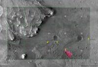
map update Mar 22 2021, 08:42 AM Phil Stooke Using Hazcams I have plotted the path to sol 31.
... Mar 22 2021, 11:34 PM Phil Stooke The partial panorama in the early drives thread gi... Mar 23 2021, 09:19 PM Art Martin Phil, I took your route map and superimposed a pho... Mar 24 2021, 01:07 AM Phil Stooke Thanks! Very useful.
Phil Mar 24 2021, 02:08 AM Andreas Plesch Another map based on the NASA geojson with simulat... Mar 24 2021, 02:45 AM kymani76
Sol 32 update. Mar 24 2021, 10:18 AM Phil Stooke We have just 5 images from sol 33 down from Persev... Mar 25 2021, 03:15 AM Andreas Plesch sol 33 update: The flight zone is 30m wide in this... Mar 25 2021, 10:43 PM MarkL [quote name='Andreas Plesch' date='Mar... Mar 26 2021, 01:31 PM Andreas Plesch QUOTE (MarkL @ Mar 26 2021, 08:31 AM) How... Mar 26 2021, 04:00 PM MarkL Thanks Andreas. Keep up the great work! Mar 26 2021, 11:39 PM Phil Stooke Quick update for the drive to the airfield on sol ... Mar 26 2021, 06:51 AM pospa QUOTE (Phil Stooke @ Mar 26 2021, 07:51 A... Mar 26 2021, 09:00 AM kymani76
Sol 34 map update. Colored using merged RGB HiRi... Mar 26 2021, 10:34 AM kymani76
https://arkeomapia.si/3d/mars2020/index.html
3D v... Mar 26 2021, 01:17 PM Andreas Plesch sol34 update: larger airfield to avoid crowding, s... Mar 27 2021, 02:10 AM Phil Stooke A special map for the area where the belly pan and... Mar 27 2021, 06:37 AM markril Here's the latest addition to the Google Mars ... Apr 3 2021, 06:21 AM htspace QUOTE (markril @ Apr 3 2021, 02:21 PM) He... Apr 6 2021, 01:06 PM Phil Stooke Interesting! Thanks.
Here is a map update for... Apr 4 2021, 03:05 AM Phil Stooke I have added recent drives and the helicopter depl... Apr 4 2021, 09:28 PM kymani76
Sol 44 3D map view roughly matching today's s... Apr 7 2021, 09:21 PM Phil Stooke We had a good drive on sol 47, probably about as l... Apr 8 2021, 06:42 AM htspace QUOTE (Phil Stooke @ Apr 8 2021, 02:42 PM... Apr 8 2021, 07:32 AM markril I mentioned in my last post that the raw-image met... Apr 8 2021, 07:02 AM Phil Stooke Another drive on sol 48, getting closer to the ove... Apr 9 2021, 07:05 AM Phil Stooke Sol 49 - closer to the overlook, but not yet at th... Apr 10 2021, 07:16 AM kymani76
Sol 52 update. Flight set up (almost?) complete. Apr 13 2021, 06:13 PM Phil Stooke And my map for sol 52.
Phil
Apr 14 2021, 12:10 AM Andreas Plesch I had been away from my qgis setup. Here my update... Apr 17 2021, 07:55 PM Andreas Plesch I tried my best to register the high resolution he... Apr 24 2021, 03:46 AM Andreas Plesch I registered the second oblique helicopter view al... Apr 26 2021, 02:50 AM Phil Stooke A short drive which I was not expecting on sol 65,... Apr 26 2021, 11:19 PM Andreas Plesch For what it's worth I registered the third hel... Apr 27 2021, 01:06 PM MarkL QUOTE (Andreas Plesch @ Apr 27 2021, 01:0... Apr 27 2021, 01:27 PM Andreas Plesch Thanks. Since I used rocks and pavement patterns t... Apr 27 2021, 07:37 PM Andreas Plesch Updated maps to sol66:
full map: Apr 28 2021, 01:06 AM Antdoghalo Just to think, we are mapping the first controlled... Apr 28 2021, 02:25 AM Phil Stooke I will have a map of flight paths eventually! ... Apr 28 2021, 03:38 AM Andreas Plesch A mosaic of the four Ingenuity images, registered ... Apr 28 2021, 08:21 PM Phil Stooke Good stuff, Andreas!
Here is my more detailed ... May 1 2021, 09:26 PM markril Google Mars for sol 72:
Position is dead reckon... May 4 2021, 12:59 AM Phil Stooke Good location! Here's my version.
Phil
May 4 2021, 02:10 AM Andreas Plesch another take: May 4 2021, 04:06 AM Phil Stooke A short drive on sol 73 crosses a sandy patch as s... May 5 2021, 12:20 AM Andreas Plesch A sol73 map using the updated geojson for the trav... May 5 2021, 03:31 PM Phil Stooke I'm still trying to decide what map coverage I... May 7 2021, 12:36 AM Andreas Plesch I registered the flight map released today and di... May 7 2021, 02:38 AM Phil Stooke Great work, Andreas. Here is a map for Ingenuity... May 7 2021, 06:10 PM kymani76
And my version.... May 8 2021, 10:55 AM Thorsten Denk How did you pinpoint the return point with centime... May 8 2021, 11:41 AM kymani76 It's a GIS derived value from the midpoint to ... May 8 2021, 11:50 AM kymani76
Sol 77 / flight 5 update. Landing location estima... May 8 2021, 06:45 PM Andreas Plesch https://mars.nasa.gov/resources/25900/nasas...n-ne... May 8 2021, 07:05 PM Phil Stooke This is a Mastcam-Z image pre-landing, roughly str... May 8 2021, 09:27 PM Phil Stooke Sol 84 - a drive to the west (a bit north of west ... May 16 2021, 06:55 AM Andreas Plesch sol 84 update from the updated waypoint and traver... May 16 2021, 11:42 PM Phil Stooke Just a short drive on sol 86, to put a knobbly roc... May 18 2021, 11:45 PM Andreas Plesch Based on the flight 6 announcement and the high re... May 22 2021, 04:04 AM Phil Stooke Sol 91 - a shortish drive to the south, maybe 25 m... May 23 2021, 06:48 PM Station QUOTE (Phil Stooke @ May 23 2021, 08:48 P... May 24 2021, 05:50 AM Phil Stooke The symbol is the approximate location of the heli... May 24 2021, 06:26 AM Andreas Plesch A larger map with the json traverse to the current... May 27 2021, 04:02 AM Phil Stooke This is my best guess at the moment for flight 6. ... May 28 2021, 12:29 AM Andreas Plesch QUOTE (Phil Stooke @ May 27 2021, 08:29 P... May 28 2021, 01:13 AM
Marz excellent! There's a white blob in the sa... Feb 23 2021, 04:39 PM djellison Easy test - go find the location in this map. If ... Feb 23 2021, 05:04 PM Andreas Plesch Following up on registering as accurately as possi... Mar 3 2021, 04:37 AM Phil Stooke OK, first drive, first map. It's a close-up, ... Mar 5 2021, 10:15 PM PDP8E ... and so it begins... surprise us! Mar 5 2021, 10:51 PM Phil Stooke OK, it did surprise me. We are outside my base ma... Mar 6 2021, 08:51 PM Andreas Plesch I had noticed that offset as well. It seems to me ... Mar 6 2021, 10:14 PM kymani76
My take at the landing map and first drives. It ... Mar 7 2021, 12:59 PM kymani76
Another take at the Perseverance's landing m... Mar 7 2021, 01:06 PM kymani76 It's already time to update...sol 16
Mar 7 2021, 02:48 PM Andreas Plesch And here is my take:
I am assigning CRS ESRI:10... Mar 7 2021, 03:23 PM Phil Stooke Map updated to sol 16. I hope for some feature na... Mar 7 2021, 07:10 PM Julius Dont know if its the correct site to post this but... Mar 7 2021, 07:26 PM Andreas Plesch I did find a slightly earlier frame of the Rover L... Mar 7 2021, 10:39 PM Phil Stooke I revised my map from earlier to include the sol 1... Mar 10 2021, 03:21 AM Phil Stooke Iteratively building these maps. I have added the... Mar 10 2021, 09:27 PM MarkL Thanks as always Phil. This is a great resource. Mar 10 2021, 09:45 PM markril ... and to continue the discussion on registration... Mar 11 2021, 04:57 AM Phil Stooke This is the sol 20 drive. The location should be ... Mar 12 2021, 12:30 AM Andreas Plesch Here is my best estimate of the current location, ... Mar 12 2021, 02:55 AM kymani76
Sol 20 update with newly available raw EDL image... Mar 12 2021, 09:13 AM Andreas Plesch My estimate was a few meters off. With the latest ... Mar 12 2021, 01:42 PM markril For the Google Mars track, there's now an auto... Mar 12 2021, 07:16 PM Phil Stooke The images for the last couple of days have not be... Mar 15 2021, 08:26 PM Andreas Plesch Here is a map using the latest geojson, with regis... Mar 16 2021, 12:12 AM nprev Some members have observed, and I agree, that this... Mar 16 2021, 03:50 AM Phil Stooke Good idea.
I have adjusted the base of my interme... Mar 16 2021, 07:42 AM Phil Stooke This map shows feature names around the landing ar... Mar 16 2021, 07:07 PM kymani76
sol 23 update
Only Rover Descent Camera images ar... Mar 16 2021, 10:59 PM Phil Stooke This is my previous map with the appropriate chara... Mar 17 2021, 09:19 PM Phil Stooke Sol 30 update:
Phil Mar 21 2021, 09:40 PM kymani76
map update Mar 22 2021, 08:42 AM Phil Stooke Using Hazcams I have plotted the path to sol 31.
... Mar 22 2021, 11:34 PM Phil Stooke The partial panorama in the early drives thread gi... Mar 23 2021, 09:19 PM Art Martin Phil, I took your route map and superimposed a pho... Mar 24 2021, 01:07 AM Phil Stooke Thanks! Very useful.
Phil Mar 24 2021, 02:08 AM Andreas Plesch Another map based on the NASA geojson with simulat... Mar 24 2021, 02:45 AM kymani76
Sol 32 update. Mar 24 2021, 10:18 AM Phil Stooke We have just 5 images from sol 33 down from Persev... Mar 25 2021, 03:15 AM Andreas Plesch sol 33 update: The flight zone is 30m wide in this... Mar 25 2021, 10:43 PM MarkL [quote name='Andreas Plesch' date='Mar... Mar 26 2021, 01:31 PM Andreas Plesch QUOTE (MarkL @ Mar 26 2021, 08:31 AM) How... Mar 26 2021, 04:00 PM MarkL Thanks Andreas. Keep up the great work! Mar 26 2021, 11:39 PM Phil Stooke Quick update for the drive to the airfield on sol ... Mar 26 2021, 06:51 AM pospa QUOTE (Phil Stooke @ Mar 26 2021, 07:51 A... Mar 26 2021, 09:00 AM kymani76
Sol 34 map update. Colored using merged RGB HiRi... Mar 26 2021, 10:34 AM kymani76
https://arkeomapia.si/3d/mars2020/index.html
3D v... Mar 26 2021, 01:17 PM Andreas Plesch sol34 update: larger airfield to avoid crowding, s... Mar 27 2021, 02:10 AM Phil Stooke A special map for the area where the belly pan and... Mar 27 2021, 06:37 AM markril Here's the latest addition to the Google Mars ... Apr 3 2021, 06:21 AM htspace QUOTE (markril @ Apr 3 2021, 02:21 PM) He... Apr 6 2021, 01:06 PM Phil Stooke Interesting! Thanks.
Here is a map update for... Apr 4 2021, 03:05 AM Phil Stooke I have added recent drives and the helicopter depl... Apr 4 2021, 09:28 PM kymani76
Sol 44 3D map view roughly matching today's s... Apr 7 2021, 09:21 PM Phil Stooke We had a good drive on sol 47, probably about as l... Apr 8 2021, 06:42 AM htspace QUOTE (Phil Stooke @ Apr 8 2021, 02:42 PM... Apr 8 2021, 07:32 AM markril I mentioned in my last post that the raw-image met... Apr 8 2021, 07:02 AM Phil Stooke Another drive on sol 48, getting closer to the ove... Apr 9 2021, 07:05 AM Phil Stooke Sol 49 - closer to the overlook, but not yet at th... Apr 10 2021, 07:16 AM kymani76
Sol 52 update. Flight set up (almost?) complete. Apr 13 2021, 06:13 PM Phil Stooke And my map for sol 52.
Phil
Apr 14 2021, 12:10 AM Andreas Plesch I had been away from my qgis setup. Here my update... Apr 17 2021, 07:55 PM Andreas Plesch I tried my best to register the high resolution he... Apr 24 2021, 03:46 AM Andreas Plesch I registered the second oblique helicopter view al... Apr 26 2021, 02:50 AM Phil Stooke A short drive which I was not expecting on sol 65,... Apr 26 2021, 11:19 PM Andreas Plesch For what it's worth I registered the third hel... Apr 27 2021, 01:06 PM MarkL QUOTE (Andreas Plesch @ Apr 27 2021, 01:0... Apr 27 2021, 01:27 PM Andreas Plesch Thanks. Since I used rocks and pavement patterns t... Apr 27 2021, 07:37 PM Andreas Plesch Updated maps to sol66:
full map: Apr 28 2021, 01:06 AM Antdoghalo Just to think, we are mapping the first controlled... Apr 28 2021, 02:25 AM Phil Stooke I will have a map of flight paths eventually! ... Apr 28 2021, 03:38 AM Andreas Plesch A mosaic of the four Ingenuity images, registered ... Apr 28 2021, 08:21 PM Phil Stooke Good stuff, Andreas!
Here is my more detailed ... May 1 2021, 09:26 PM markril Google Mars for sol 72:
Position is dead reckon... May 4 2021, 12:59 AM Phil Stooke Good location! Here's my version.
Phil
May 4 2021, 02:10 AM Andreas Plesch another take: May 4 2021, 04:06 AM Phil Stooke A short drive on sol 73 crosses a sandy patch as s... May 5 2021, 12:20 AM Andreas Plesch A sol73 map using the updated geojson for the trav... May 5 2021, 03:31 PM Phil Stooke I'm still trying to decide what map coverage I... May 7 2021, 12:36 AM Andreas Plesch I registered the flight map released today and di... May 7 2021, 02:38 AM Phil Stooke Great work, Andreas. Here is a map for Ingenuity... May 7 2021, 06:10 PM kymani76
And my version.... May 8 2021, 10:55 AM Thorsten Denk How did you pinpoint the return point with centime... May 8 2021, 11:41 AM kymani76 It's a GIS derived value from the midpoint to ... May 8 2021, 11:50 AM kymani76
Sol 77 / flight 5 update. Landing location estima... May 8 2021, 06:45 PM Andreas Plesch https://mars.nasa.gov/resources/25900/nasas...n-ne... May 8 2021, 07:05 PM Phil Stooke This is a Mastcam-Z image pre-landing, roughly str... May 8 2021, 09:27 PM Phil Stooke Sol 84 - a drive to the west (a bit north of west ... May 16 2021, 06:55 AM Andreas Plesch sol 84 update from the updated waypoint and traver... May 16 2021, 11:42 PM Phil Stooke Just a short drive on sol 86, to put a knobbly roc... May 18 2021, 11:45 PM Andreas Plesch Based on the flight 6 announcement and the high re... May 22 2021, 04:04 AM Phil Stooke Sol 91 - a shortish drive to the south, maybe 25 m... May 23 2021, 06:48 PM Station QUOTE (Phil Stooke @ May 23 2021, 08:48 P... May 24 2021, 05:50 AM Phil Stooke The symbol is the approximate location of the heli... May 24 2021, 06:26 AM Andreas Plesch A larger map with the json traverse to the current... May 27 2021, 04:02 AM Phil Stooke This is my best guess at the moment for flight 6. ... May 28 2021, 12:29 AM Andreas Plesch QUOTE (Phil Stooke @ May 27 2021, 08:29 P... May 28 2021, 01:13 AM |

|
Lo-Fi Version | Time is now: 20th June 2024 - 01:53 AM |
|
RULES AND GUIDELINES Please read the Forum Rules and Guidelines before posting. IMAGE COPYRIGHT |
OPINIONS AND MODERATION Opinions expressed on UnmannedSpaceflight.com are those of the individual posters and do not necessarily reflect the opinions of UnmannedSpaceflight.com or The Planetary Society. The all-volunteer UnmannedSpaceflight.com moderation team is wholly independent of The Planetary Society. The Planetary Society has no influence over decisions made by the UnmannedSpaceflight.com moderators. |
SUPPORT THE FORUM Unmannedspaceflight.com is funded by the Planetary Society. Please consider supporting our work and many other projects by donating to the Society or becoming a member. |
|